By Todd Nelson
According to a recent report by NASA, average high temperatures recorded by the Mars Rover Curiosity, have been comparable to what we experienced Monday! Our overnight lows have actually been colder than highs recorded on the surface of Mars, so next time your family calls from Phoenix, you can tell them how hardy us Minnesotans really are!
Dangerous wind chills continue Tuesday as the core of the Arctic air continues to slowly ease east. We have a better shot at getting above zero for daytime highs Wednesday and possibly back to the teens by Thursday! The heat wave continues through the end of the week as highs near 30F can't be ruled out by Friday and Saturday.
It's amazing how warm 20s feels, let alone 30F after such cold weather. I just got back from Vegas, where high temps were in the 60s, so the 80F+ temperature swing was a bit rough.
I am a firm believer in well timed vacations. Either that or staying inside with the window shades drawn and living vicariously through friends/family members that are basking in the sun on some tropical beach.
Hang in there, the nasty stuff is almost done. We'll back back to normal in no time. -Todd Nelson
_____________________________________________________________
MONDAY NIGHT: Wind Chill Warning. Partly cloudy - still frigid. Low: -21. Feels Like: -45F. Winds: W 10-15.
TUESDAY: Wind Chill Warning until noon. More sun, less wind. High: -1. Feels like -35F. Winds: W 5-10.
TUESDAY NIGHT: Still cold. Low: -11. Feels Like: -20F. Winds: WNW 5.
WEDNESDAY: Blue sky. Hello zero! High: 3.
THURSDAY: Some sun, not nearly as harsh. Wake-up: -6. High: 14
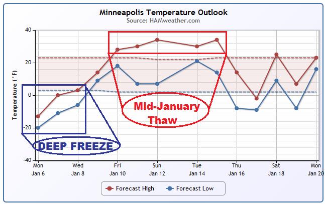
FRIDAY: Mostly cloudy, risk of a thaw. Wake-up: 11. High: 31
SATURDAY: Dripping icicles. Much better. Wake-up: 19. High: 30
SUNDAY: Cloudy, above average temps. Wake-up: 18. High: 33.
Monday: Breezy. Not too bad. Wake-up: 19. High: 30.
______________________________________________________________
This Day in Weather History
January 7th
2003: Record warmth over Minnesota. Many places reach the 50's including the Twin Cities. St. James hit 59 and the Twin Cities reached 51. Nine golf courses were open in the Twin Cities and 100 golfers were already at the Sundance Golf Course in Maple Grove in the morning.
1873: Great Blizzard. Three day blizzard caused extreme hardship for pioneers from out east who were not used to the cold and snow. Visibility was down to three feet. Cows suffocated in the deep drifts and trains were stuck for days. More than 70 people died, some bodies were not found until spring. Weather conditions before the storm were mild, just like the Armistice Day storm.
______________________________________________________________
Deep Freeze Continues
Extreme cold continues through midweek with the coldest of the cold lasting until Tuesday. Temperatures warm a bit through the end of the week with 30s possible by the weekend ahead! It looks like a Minnesota heat wave to me!
Extremely Cold Monday
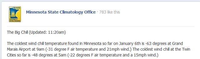
WOW! How about some of these readings! Thanks to the Minnesota State Climatology Office for these stats.
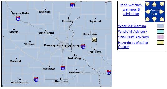
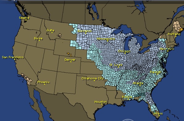
Wind Chill Warning Continues...
.A WIND CHILL WARNING REMAINS IN EFFECT FOR CENTRAL AND SOUTHERN MINNESOTA AND WEST CENTRAL WISCONSIN THROUGH NOON TUESDAY. THE COLDEST AIR MASS SINCE 1996 WILL CONTINUE TO BRING DANGEROUS WIND CHILLS TO THE REGION THROUGH TUESDAY MORNING. THE ARCTIC COLD IS ACCOMPANIED BY BRISK NORTHWEST WINDS. THE COMBINATION OF THE COLD AND WIND WILL PRODUCE WIND CHILLS OF 35 BELOW TO 55 BELOW ZERO THROUGH TUESDAY MORNING. THIS IS A LIFE-THREATENING SITUATION. WIND CHILLS COLDER THAN 50 BELOW ZERO CAN CAUSE EXPOSED FLESH TO FREEZE IN ONLY 5 MINUTES. COVER AS MUCH FLESH AS POSSIBLE WHEN VENTURING OUT.
______________________________________________________
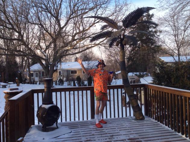
Cold Enough For Ya?
Thanks to Gene Hokenson for this interesting picture out of Prior Lake, MN, who obviously seems to be enjoying this cold weather! HA! Glad someone can have a little fun during this Arctic slap.
Dangerous Cold Continues
I
can honestly say that I'm not sure if I've seen such large wind chill
advisory/warning map in my life! Of course, depending on your location
the criteria for these advisories/warnings are much different, but
ranging from Florida to the international border, wind chill values
could be anywhere from 0F to -60F!
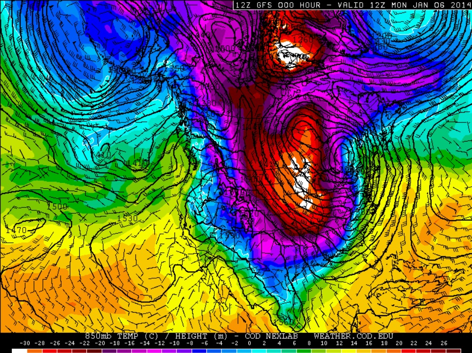
Coldest of the Cold
Thanks
to a large winter storm that moved through across the central part of
the country over the weekend, this latest cold blast came on the heels
of the heavy snow dump. The image below shows core of the coldest air on
Monday morning over the Midwest/Great Lakes Region.
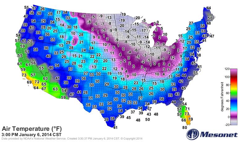
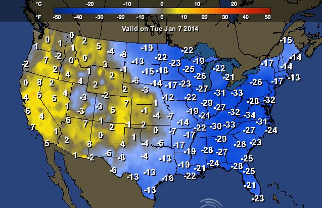
Extreme Cold
Unfortunately,
there were a number of locations that didn't even get above 0F on
Monday afternoon. Take a look at how cold it was mid-afternoon Monday.
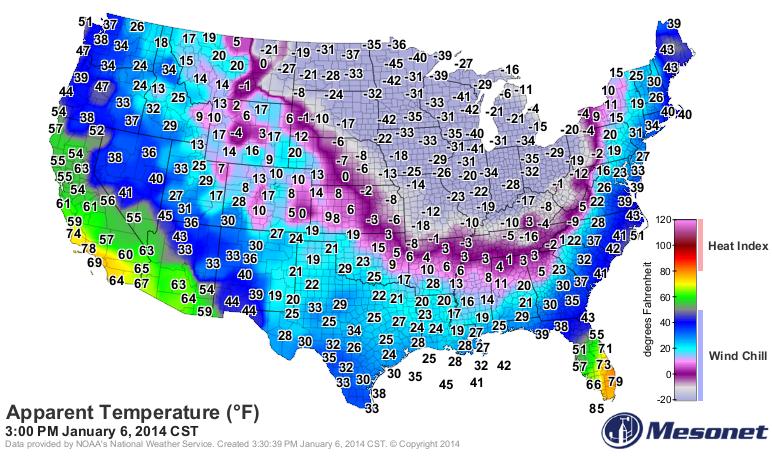
Factoring
in the wind, feels like temperatures were still in the dangerous
category even during what typically one of the warmest parts of the day.
Canada Cryoseisms?
This
might be a new one for you... it is for me. It has been so cold in
parts of Canada that some residents have been reporting hearing and
feeling mini explosions!
"Residents
across Toronto and beyond are reporting being awoken early Friday
morning by loud booms, which experts say were frost quakes.
Frost quakes, also known as cryoseisms, occur after precipitation and bitterly cold temperatures.
“Ice can be very rigid at cold temperatures, and as it expands it’s trying to find room for itself and it can build up tremendous pressure,” Cathy Woodgold, a seismologist with Earthquake Canada, told CTV Toronto on Friday."
Read more from CTVNews.ca HERE:

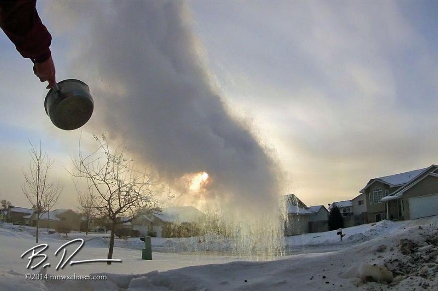
Fun With Cold Weather?
Even though the extreme cold can be quite dangerous, it can also be fun if you're cold weather experiments...
Here are some.
Thanks to my good friend Bill Doms for this picture, who threw hot water into the air and turned it into a cloud of tiny ice crystals... pretty cool!
See More from www.mxwxchaser.com HERE:
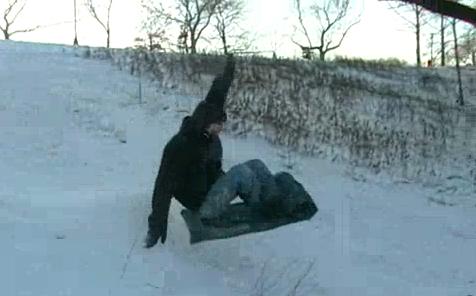
Here's another one from nziegler who turned a towel into a great looking sled!
Watch the video HERE:
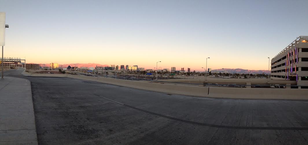
Where is it Warm?
I wish I could teleport back to this spot. It's the Las Vegas airport, where temperatures were in the 60s last week! It was almost a 90F temperature swing for me in just a matter of days...
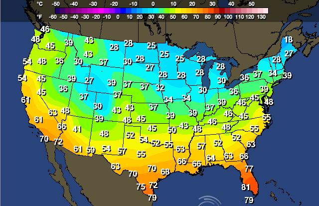
High Temps For Tuesday
Most locations around the country will cooler than average on Tuesday, except for those in the southwestern part of the country.
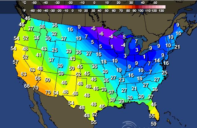
In fact, temperatures in the southwestern part of the country will be nearly 5F to 10F above average, while much of the eastern part of the country will be nearly 15F to 30F below average.
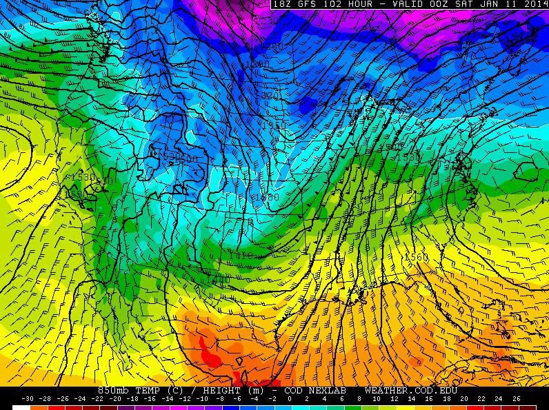
Warming Trend!
The good news is that by the end of the week, temperatures look to be warming considerably from where they are now! The image below shows temperatures a few thousand feet off the ground by Friday, note how the nasty cold blob has nearly disappeared
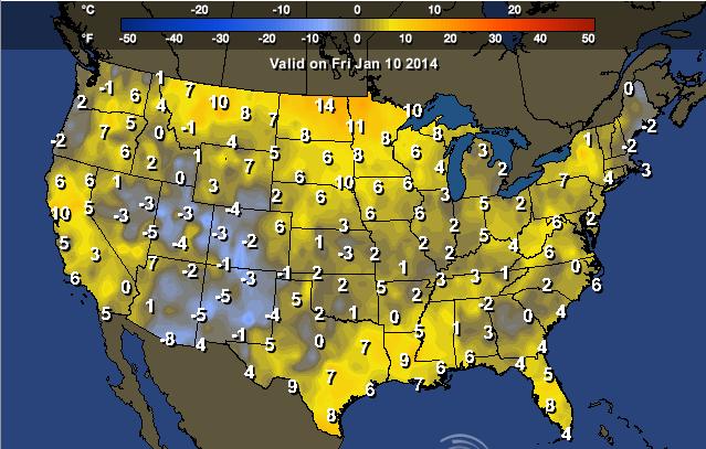
Highs Friday
Highs From Normal Friday
Cold & Snowy Start to January 2014
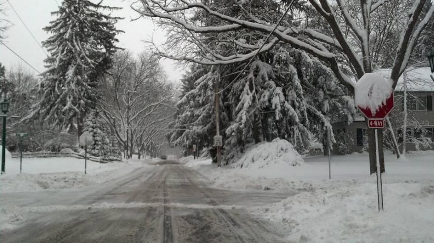
Since the beginning of January, we've had two snow storms that have moved through the eastern half of the country. The latest moved across the central part of the country into the Great Lakes Region with nearly 20" of snow in spots from Indiana to Michigan. Thanks to Steve Scuba who snapped this picture from Toledo, OH this weekend.
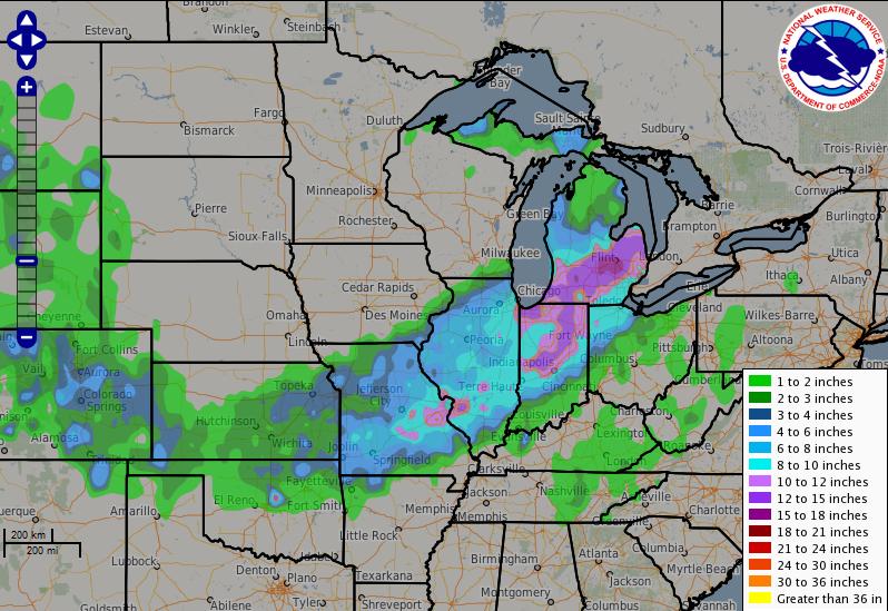
Snow Since the Weekend
Here's a nice graph of the snow that fell over the weekend. Note the more intense snowfall tallies closer to the Great Lakes Region, where some picked up nearly 20"
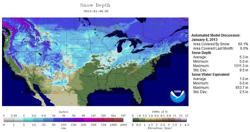
U.S. Snow Cover
With the latest snow events over the past several days, NOAA is now reporting that nearly 52% of the country is covered in snow.
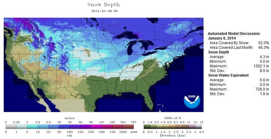
By this time last year, nearly 60% of the nation had been covered in snow
Additional Snow Chances
As we continue through midweek, a weak clipper is expected to dive in from Canada, while an additional low develops in the central part of the country. This will likely bring some light snow chances back into areas that just had snow, but it doesn't appear to be as much as what we've just seen.
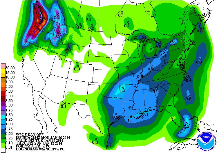
5 Day Precipitation Outlook
Here's the precipitation forecast through Saturday. As temperatures warm in to the weekend, some of this precipitation in the central part of the country will be in the form of rain.
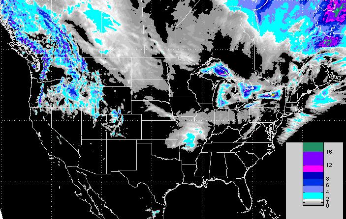
Snowfall Forecast
The snowfall forecast through midday Thursday doesn't appear to be much in the central part of the country, however look at the heavier tallies in the western mountains along with those snowfall amounts near the Great Lakes Region.
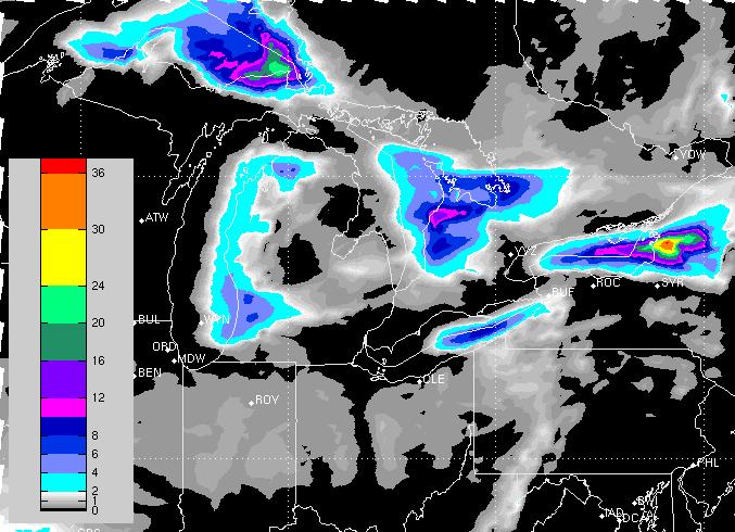
Significant Lake Effect Snow
Look at some of these impressive snowfall forecasts across the Great Lakes. Lake effect snow tallies through midweek could be added up in feet by the time it's all said and done downwind of Lake Ontario.
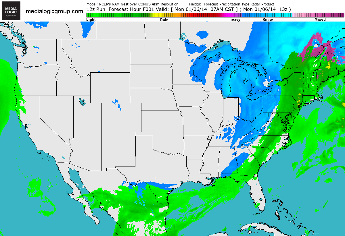
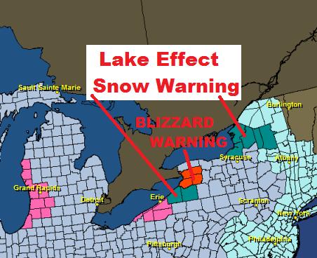
Lake Effect Snow
Heavy snow and blowing snow will be significant through Tuesday. Lake effect snow and blizzard warnings have been issued downwind of the eastern Great Lakes.
* TIMING...THROUGH LATE TUESDAY NIGHT.
* HAZARDS...BLIZZARD CONDITIONS FROM LAKE EFFECT SNOW AND BLOWING SNOW.
* SNOW ACCUMULATIONS...6 TO 12 INCHES TONIGHT...9 TO 17 INCHES TUESDAY...AND 1 TO 3 INCHES TUESDAY NIGHT...LEADING TO STORM TOTALS OF MORE THAN 3 FEET IN THE MOST PERSISTENT LAKE SNOWS.
* WINDS...SOUTHWEST 20 TO 30 MPH...GUSTS TO 45 MPH.
* VISIBILITIES...NEAR ZERO IN WHITEOUT CONDITIONS AT TIMES.
____________________________
* LOCATIONS...JEFFERSON AND LEWIS COUNTIES.
* TIMING...THROUGH EARLY WEDNESDAY AFTERNOON.
* HAZARDS...HEAVY LAKE EFFECT SNOW AND BLOWING SNOW.
* ACCUMULATIONS...MORE THAN 2 FEET TONIGHT...MORE THAN 2 FEET TUESDAY...10 TO 20 INCHES TUESDAY NIGHT...AND 3 TO 5 INCHES WEDNESDAY LEADING TO STORM TOTALS OF 6 FEET IN THE HEART OF THE BAND.
Thanks for checking in and have a great rest of your week ahead! Don't forget to check me out on Twitter @TNelsonWNTV

No comments:
Post a Comment