28 F. high in the Twin Cities Tuesday.
23 F. average high on January 14.
14 F. high on January 14, 2013.
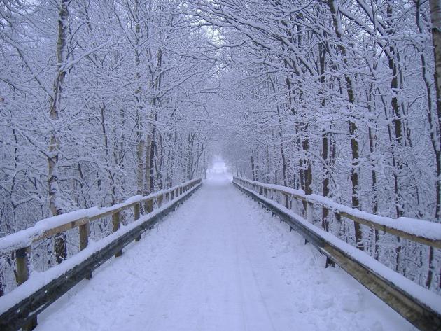
4.1" snow fell yesterday at MSP International Airport.
9" snow on the ground in the Twin Cities.
Minnesota Weather History on January 14 (courtesy of the Twin Cities National Weather Service).
1981: Over 24,000 Canadian Geese are at Silver Lake in Rochester.
1952:
Glaze, Sleet and Ice storm across Minnesota from St Cloud south into
Iowa. 1,100 Northwestern Bell telephone wires down. The Buffalo Ridge in
the Pipestone area the hardest hit with 3/4 inches of solid ice on
Northern State Power wires with icicles to 3 inches. Northwestern Bell
reported ice to 1 1/2 inches of ice on their wires in the same area.
Thunder and a shower of ice pellets accompanied the storm in New Ulm and
Mankato. Minneapolis General Hospital treated 81 people, victims of
falls on icy streets.
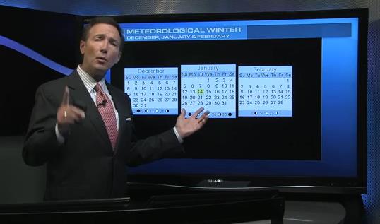
Turning Around
No,
spring is NOT right around the corner. Cold fronts are as inevitable as
mosquito swarms, internet snark and cheap media hype. But you could
make a strong case that, historically, temperatures bottom out this
week. Today marks the midpoint of meteorological winter, which doesn't
have the good sense to follow the calendar.
On average the coldest
90 days of the year come from December 1 to February 28, give or take.
Looking at 1981-2010 January temperature averages (
here, courtesy of the Minnesota Climatology Working Group) the midpoint of the coldest "mean" temperature - 15F - is today.
Although more gasps of numbing air are inevitable I don't see it getting colder than last week's almost surreal Mars-like chill.
Small comfort.
And we've picked up nearly half an hour of daylight since the Winter Solstice; almost an hour by the end of January. Woo hoo!
After
a cold start the next clipper draws milder air into Minnesota; 32F by
midnight before another temperature relapse. A surge of 30s return by
Sunday & Monday. Another slap of colder air arrives next week - but a
pale imitation of last week's Polar Express.
Prepare for a family of nuisance clippers - the pattern just isn't ripe for any big, snowy dumpings anytime soon.
A (Faint) Whiff Of Good Weather News.
Here we are, at the midpoint of meteorological winter. Average
temperatures begin to rise within a few days as a higher sun angle
finally begins to compensate for long nights and lingering snowcover
over Canada. That's the focus of today's edition of
Climate Matters: "
WeatherNationTV
Chief Meteorologist Paul Douglas shows the midpoint of meteorological
winter. It can only go up from here. Many temps should trend milder, but
its not all good news. The high pressure set up, similar to the one in
1976-1977, has helped January all time high temps to Oregon and the
direst year on record for California."
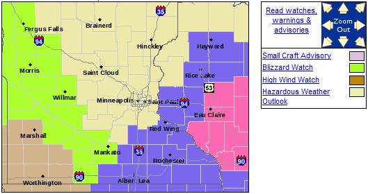
Blizzard Watch.
The arrival of a blustery Alberta Clipper may spark 30-50 mph wind
gusts tonight into Thursday, and Blizzard Watches are posted for
(blowing) snow with potential white-out conditions over parts of
southwest and west central Minnesota. Details from the MPX office of the
National Weather Service:
.A BLIZZARD WATCH IS IN EFFECT FROM THURSDAY MORNING THROUGH
THURSDAY EVENING FOR MUCH OF WEST CENTRAL THROUGH SOUTH CENTRAL
MINNESOTA. THE BLIZZARD WATCH IS ALONG AND WEST OF A LINE FROM
ALEXANDRIA THROUGH WILLMAR TO BLUE EARTH.

AN ARCTIC COLD FRONT WILL MOVE SOUTHEAST ACROSS THE MINNESOTA
RIVER VALLEY THURSDAY MORNING ACCOMPANIED BY A PERIOD OF SNOW.
STRONG NORTHWEST WINDS NEAR 35 MPH... WITH GUSTS TO 55 MPH... ARE
LIKELY IN THE WAKE OF THE FRONT. THE COMBINATION OF THE SNOW AND
STRONG WINDS MAY RESULT IN BLIZZARD CONDITIONS... WITH NEAR ZERO
VISIBILITIES... DURING THE DAY AND EVENING. IN ADDITION...
TEMPERATURES WILL PLUMMET INTO THE SINGLE DIGITS ABOVE ZERO
THURSDAY AFTERNOON WITH WIND CHILL READINGS APPROACHING 30 BELOW
ZERO.
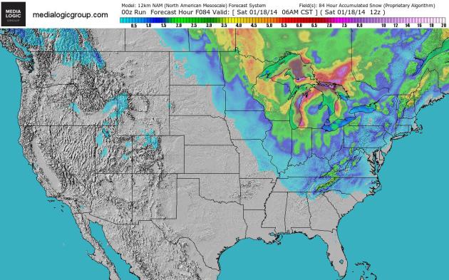
84 Hour Snowfall.
NOAA's NAM model shows significant snowfall amounts downwind of the
Great Lakes, classic lake effect snow squalls. As much as 2-4" of fresh
powder may fall closer to Duluth and Hibbing. Map: NOAA and Ham Weather.
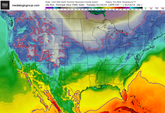
Canadian Slaps.
Although not nearly as numbing as a week ago, the next cold surge
arriving Thursday and Friday will trigger nighttime lows below zero over
the Upper Mississippi Valley and Great Lakes; the freezing line (solid
red line) pushing into the Florida Panhandle. 2-meter NAM guidance
courtesy of NOAA and Ham Weather.
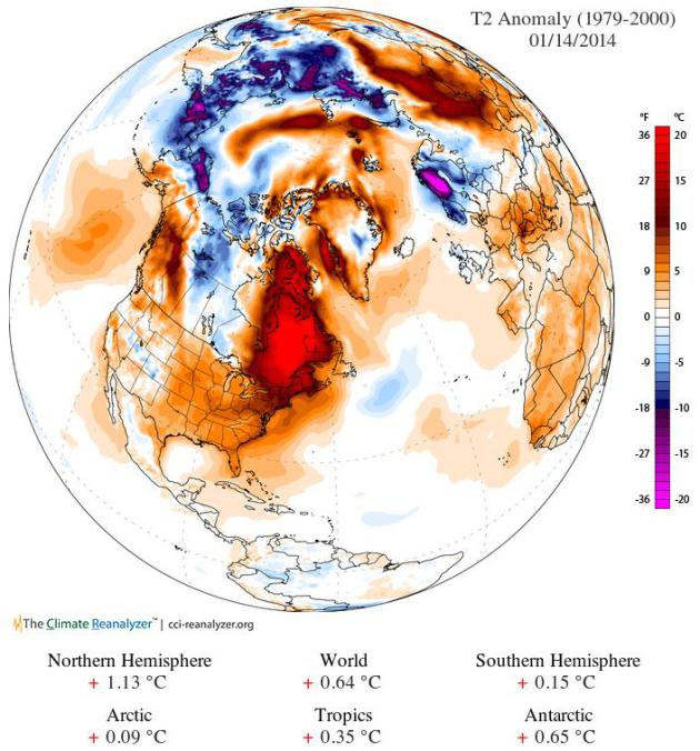
Recovery.
After last week's surreal blast of polar air, temperatures have warmed
quite rapidly over much of the Northern Hemisphere, Tuesday temperature
anomalies well above average across eastern Canada and Siberia. We'll
see more cold fronts (there's a safe forecast) but I still think last
week was the worst of it. Image above: The Climate Reanalyzer.
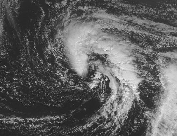
An Early Start To Hurricane Season? "Subtropical" Storm May Be Forming.
Could we wind up with Tropical Storm Arthur - in January? Highly
unusual, but not unprecedented. Here's a clip from a good analysis at
Capital Weather Gang: "...
The
official Atlantic hurricane season spans June 1 through November 30,
but nature does not always obey our arbitrary boundaries. On average,
about 97% of tropical cyclone activity falls within the official
hurricane season, while the remaining 3% is spread out among the six
off-season months. Looking back to 1851, only two known storms have
formed during January: Hurricane #1 in 1938 (formed January 3), and
Subtropical Storm #1 in 1978 (formed on January 18)..."
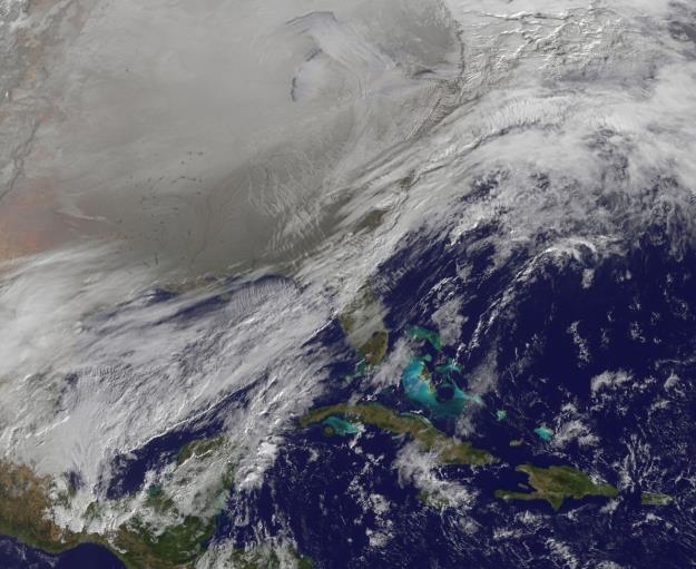
Image credit above: "
Visible satellite image from 9:15 am this morning." (NASA).
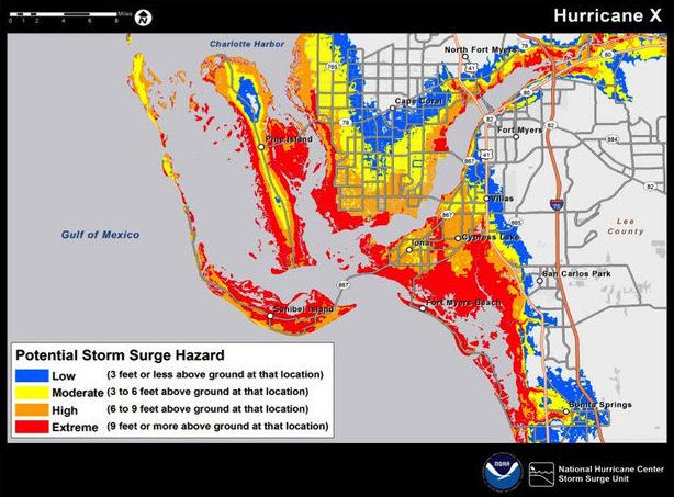
National Hurricane Center To Use Test Storm Surge Maps During 2014 Hurricane Season. This is a new development - here's an excerpt courtesy of New Orlean's based
nola.com: "
The National Hurricane Center will issue maps showing potential flooding
from storm surges during tropical storms and hurricanes on a trial
basis during the 2014 Atlantic hurricane season that begins June 1, to
warn residents of dangers other than wind associated with the storms,
center Director Rick Knabb said Tuesday (Jan. 7)....Knabb made the
announcement during a panel discussion on efforts by the center and the
National Weather Service to move away from focusing on hurricane or
tornado categories in public messages, and instead emphasizing
information that helps the public understand specific risks posed by the
weather systems..."
Image credit above: "
This is
an early version of the storm surge inundation map that will be tested
by the National Hurricane Center during the 2014 hurricane season. The
wording of the key shown in this map of the Fort Myers, Fla., area is
likely to change in the test versions."
(National Hurricane Center).
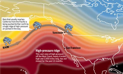
California Drought: What's Causing It?
2013 was the driest year in recorded California history, and a
persistent ridge of high pressure continues to deflect wet, Pacific
storms well north, prompting worries of an even more serious drought in
2014. Here's a clip of a good explanation from the
San Jose Mercury News: "...
With each passing week, California's lack of rainfall becomes more serious. Last
year was the driest calendar year in recorded history in California in
most cities, with records going back 160 years. The first snowpack
reading in the Sierra Nevada earlier this month found a snowpack of just
20 percent of normal..."
Weather graphic above: WeatherWest.com.
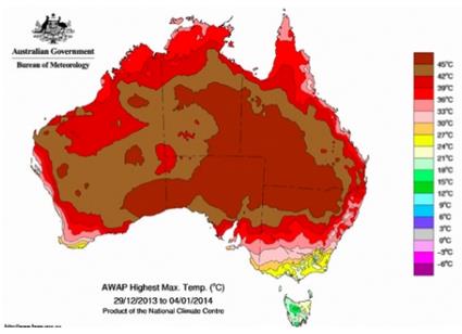
Australia's 2014 Heat Wave Picks Up Where 2013 Left Off.
The continent Down Under is baking - another record year of heat and
brush fires may be shaping up, according to this clip from
Climate Central: "...
The U.S. may just be climbing out of the freezer,
but Australia has been sweating through a major heat wave to start the
year. Heat records fell across a large part of the country in the first
week of the New Year. The warm weather is currently centered
over sparsely populated Western Australia, but it could hit major
population centers along the east coast by late next week. The Australian Bureau of Meteorology released a special statement to chronicle the extent of the heat wave and its movement. While noting that it didn’t affect as wide an area as the January 2013 heat wave,
the statement said the heat wave has been, “highly significant with
substantial areas having their hottest day on record.” The heat wave
comes on the heels of Australia’s hottest year on record during which a slew of records were shattered, including the country's hottest summer..."
Image credit above: "
A map showing the highest temperatures recorded in Australia between Dec. 29, 2013-Jan. 4, 2014." Source: Bureau of Meteorology.
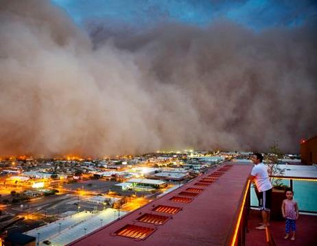
Death Dust: The Valley Fever Menace.
As if we don't have enough to be paranoid about. Toxic, soil-dwelling
fungus, swept hundreds of miles by dust storms? Here's a clip from a
story by Dana Goodyear at
The New Yorker: "...
In
2012, valley fever was the second-most-reported disease in Arizona;
two-thirds of the country’s cases occur in the state. There is no
vaccine to protect against it and, in the most severe cases, no cure.
The population of Phoenix has grown by ten per cent in the past decade,
and newcomers have no acquired immunity. The elderly and the
immune-compromised—including pregnant women—are most susceptible; for
unknown reasons, otherwise healthy African-Americans and Filipinos are
disproportionately vulnerable to severe and life-threatening forms of
the disease..."
Image credit above: "
Dust storms
in the West stir up microscopic spores of the toxic soil-dwelling fungus
Coccidioides immitis. The Centers for Disease Control reports a tenfold
increase in infections, some of them fatal."
Single Digit Danger: Why Cold Weather Raises Heart Risks. Here's an excerpt of a timely and interesting article at
Consumer Affairs: "...
When
temperatures plunge your chance of having a heart attack goes up if you
already have a higher risk of heart trouble. Here's why: cold
temperatures can constrict arteries and raise blood pressure, causing
the heart to work harder or triggering tears or clots in the arteries.
Compared to the summer months, people are 26% to 36% more likely to die
in winter heart-related health issues, according to research cited by
AARP..."
Are Snowflakes Really All Different? A great question, one that comes up frequently. Here's an excerpt of a good response at
The Red and Black: "...
For
some time there was some debate about that, but there’s actually been
some fairly recent research that suggests, yes indeed, it’s likely that
all snowflakes are very unique,” said J. Marshall Shepherd, director of
atmospheric science and the Georgia Athletic Association’s professor of
geography. “There’s probably not two identical snowflakes that we could
find...”
Scientists: Americans Are Becoming Weather Wimps.
The reality: we're seeing fewer of the polar invasions that swept
across the USA last week, especially since 2000. So now when it does get
brutally cold for a few days it seems like the end of the world. Back
in the 70s? Business as usual. Here's a clip from
Yahoo News: "...
In
the past 115 years, there have been 58 days when the national average
temperature dropped below 18. Carbin said those occurrences often happen
in periods that last several days so it makes more sense to talk about
cold outbreaks instead of cold days. There have been 27 distinct cold
snaps. Between 1970 and 1989, a dozen such events occurred, but there
were only two in the 1990s and then none until Monday. "These types of
events have actually become more infrequent than they were in the past,"
said Carbin, who works at the Storm Prediction Center in Norman, Okla.
"This is why there was such a big buzz because people have such short
memories..."
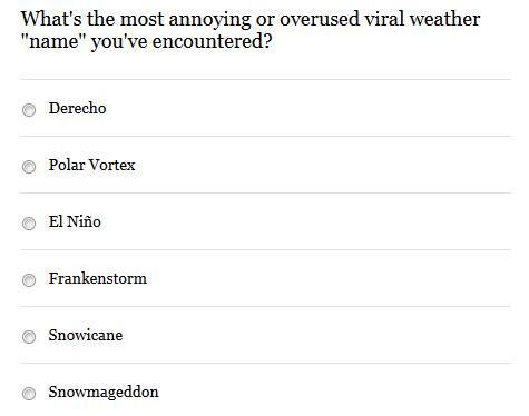
The Most Annoying Viral Weather Terms?
Last week the national media mantra was "polar vortex". But other terms
come to mind. El Nino, for one. Take the poll at the Washington Post's
Capital Weather Gang. Here's an excerpt: "
Around
every extreme weather event these days, invariably a term or name
emerges for referring to it through social and broadcast media. Some of
these descriptions are completely arbitrary, some have legitimate
meteorological pedigree, some are scientifically dubious, and/or others
might have a linkage to current events or a community. Depending on your
personality and background, you may find these names fun or –
alternatively – irritating..."
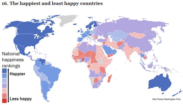
40 More Maps That Explain The World. I thought this was interesting - you can learn a lot from maps, as demonstrated by Max Fisher at
The Washington Post; here's the intro: "
Maps seemed to be everywhere in 2013, a trend I like to think we encouraged along with August's 40 maps that explain the world.
Maps can be a remarkably powerful tool for understanding the world and
how it works, but they show only what you ask them to. You might
consider this, then, a collection of maps meant to inspire your inner
map nerd. I've searched far and wide for maps that can reveal and
surprise and inform in ways that the daily headlines might not, with a
careful eye for sourcing and detail..."
Don't Go In The Water.
At least off the coast of Japan, unless you want to wrestle with a
giant squid. I'm feeling better about Minnesota's lakes, however frozen
they might be right about now. Details in this excerpt from
Huffington Post: "
Although recent reports of an enormous, radioactive squid turned out to be false, a giant squid hauled in by a fisherman in Japan last week appears to be quite real, and quite weird. The giant squid, a legendary sea creature rarely caught by humans, was netted by Shigenori Goto off Japan's Sadogashima Island in Niigata Prefecture, reports Grind TV. Local video of the squid before and after its capture claims the bizarre-looking cephalopod weighs more than 160 kg (350 pounds) and measures over 4 meters (13 feet) long..."
TODAY:
Some sun early, feels like -10. Clouds increase, a coating to 1" snow
later today. Winds: SW 10. High: 24 (rising into the 20s Wednesday
night).
WEDNESDAY NIGHT: More snow showers and flurries - coating to an inch. Low: 22
THURSDAY: Mild start, then turning blustery and colder. High: 30 (falling during the day). Blowing/drifting outside the metro may cause travel problems.
FRIDAY: Numbing start, more sunshine. Wake-up: 0. High: 10
SATURDAY: Intervals of sun, not as harsh. Wake-up: 7. High: 24
SUNDAY: January Thaw. Dripping icicles. Wake-up: 20. High: 35
MONDAY: Mild AM, chilly PM winds. Wake-up: 27. High: 34
TUESDAY: Intervals of sun, still winter. Wake-up: 6. High: 13
Climate Stories....
 U.S. Cold Snap Fuels Climate Debate
.
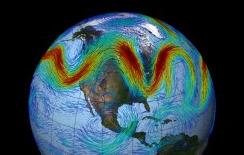
Is rapid melting of arctic ice having an impact on jet stream winds
over the Northern Hemisphere? Here's an excerpt of an article at
Nature: "...
Arctic
warming is leading to declines in sea ice and increased snowmelt on
land. Because ice and snow are bright, they reflect sunlight back into
space. When they melt, more solar energy can be absorbed by the Arctic.
One theory is that a warmer Arctic will reduce the temperature
differences between the Arctic and warmer latitudes, leading to a weaker
jet stream that would be more likely to wander off course from time to
time. “Of course, we can’t say that this particular pattern is due to
warming, but it’s very consistent with what we expect to see happen,”
says Jennifer Francis, an atmospheric scientist at Rutgers University in
New Brunswick, New Jersey, who published a study on this effect in
Geophysical Research Letters in 2012..."
Image above: NOAA/NASA GOES Project.
Researcher Defends Work Linking Arctic Warming And Extreme Weather.
This is a little technical (from August of 2013), but I thought it
relevant to the article linked above. The data set isn't long enough to
make black and white statements, but there is at least some
circumstantial and anecdotal evidence that rapid warming of far northern
latitudes are impacting the jet stream, especially since the turn of
the century. More research is needed to draw conclusive results, an idea
echoed by meteorologist Jason Samenow in this older post at the
always-interesting
The Capital Weather Gang: "....
On Monday, I wrote about a study
that pushed back against a theory that a warming Arctic and melting ice
are leading to a more volatile jet stream and an increase in extreme
weather in the U.S. and elsewhere. Jennifer Francis, an atmospheric
scientist at Rutgers University and leading proponent of the theory, has
sent me some comments vigorously defending it. Her comments are
technical, but I’ll try to extract the key points (I reproduce the
comments, in their entirety, at bottom of this post)..." Image: NASA.
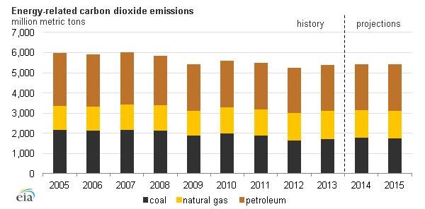
After Years Of Declines, U.S. Carbon Emissions Rose 2 Percent In 2013.
The Washington Post has the story and details; here's the introduction: "
The
United States has been one of the few bright spots for climate-change
policy in recent years. Thanks to the recession, improved efficiency
measures and the shale-gas boom, the nation's carbon-dioxide emissions
from energy fell 12 percent
between 2005 and 2012. But the party's now officially ending, at least
for those worried about global warming. In an early estimate, the U.S.
Energy Information Administration says that U.S. carbon-dioxide emissions from energy sources increased 2 percent in 2013..."
Image credit: EIA, Washington Post.
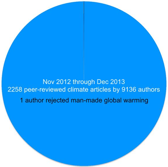
The Very, Very Thin Wedge Of Denial.
Why don't more climate doubters, skeptics and trolls publish their
works and scientific findings? Here's a clip from a story at
Slate: "...
To
me, one of the most fascinating aspects of climate change denial is how
deniers essentially never publish in legitimate journals, but instead
rely on talk shows, grossly error-laden op-eds, and hugely out-of-date
claims (that were never right to start with). n 2012, National Science
Board member James Lawrence Powell investigated peer-reviewed literature published about climate change and found that out of 13,950 articles, 13,926 supported the reality of global warming. Despite a lot of sound and fury
from the denial machine, deniers have not really been able to come up
with a coherent argument against a consensus. The same is true for a
somewhat different study that showed a
97 percent consensus among climate scientists supporting both the
reality of global warming and the fact that human emissions are behind
it..."
Graphic credit: "
Denial is a thin wedge indeed". Graphic: James Powell.
Weather Terminology 101.
Here's a clip from an interesting article focused on weather and
climate terms you may be hearing in the popular media these days,
courtesy of
onearth.org: "
The “polar vortex” that froze North America in its tracks this week
isn’t exactly new. Cyclones of frigid air swirl around the Arctic all
the time. What’s different is that this latest polar vortex dipped far
enough south to send Floridians scrambling for their mittens. The term
also showed up all over my Facebook feed. Granted, I run with a lot of
science journalists, but this time even my
let’s-take-a-picture-of-my-breakfast friends (no offense, guys) were
discussing the rare and strange interaction of the polar vortex with the
jet stream and its possible relation to melting Arctic sea ice … driven by climate change. Thanks to wacky weather (and social media hashtags), meteorology geekspeak has hit the mainstream..."
Graphic credit: Mike Fernwood, Flickr.
A Spurious Jump In The Satellite Record: Is Antarctic Sea Ice Really Expanding? Here's an excerpt of an abstract at
The Cryosphere: "...
Furthermore,
a number of recent studies have investigated physical mechanisms for
the observed expansion of the Antarctic sea ice cover. The results of
this analysis raise the possibility that this expansion may be a
spurious artifact of an error in the satellite observations, and that
the actual Antarctic sea ice cover may not be expanding at all."
Mohamed Nasheed: Some Conservatives Failed Over Mandela. Others Are Failing Now Over Climate Change. Here's a clip of an Op-Ed from the former Presidents of the Maldives, a Pacific island nation threatened by rising waters, at
Conservative Home: "...
As
climate change bites, more and more world leaders are forced to grapple
with its consequences: fiercer droughts, wildfires, storms and floods. A
denialist, Conservative movement has no solutions to offer these
countries and therefore risks irrelevancy. It also leaves Conservatives
on the wrong side of history. Over the past few weeks, as the world
commemorates Nelson Mandela, an uncomfortable spotlight has been shone
on Conservatives who branded the ANC as terrorists in the 1980s. How
will today’s crop of Conservative climate refuseniks explain themselves
to future generations, in a world made hotter, nasty and poor by global
warming? Strong action today to curb emissions should prevent
catastrophic climate change. But if we ignore the issue for another
decade, we face a world of soaring temperatures, ferocious storms and a
climate out of control. Future generations will hold
Conservatives responsible for wrecking the planet..."


No comments:
Post a Comment