Todd Nelson
Believe it or not, January is our 2nd snowiest month here in the Twin Cities with an average of 11.7". Our snowiest month on average is December with 12.2". Even though this winter seems a bit colder and snowier than normal, as of January 12th, we were sitting nearly 10" below normal snowfall for the season! December saw nearly 16" of snow, which was nearly 4" above normal, but prior to today, January was nearly 4.5" below average.
The dry start to January is mainly due to the extreme cold we experienced much of last week. The truth about "It's too cold to snow" is not entirely accurate, but it explains a lot. Not only is the atmosphere void of any substantial moisture capable of producing crippling snow events, but the extreme cold tends to shove the storm track farther south.
Now that temperatures have warmed a bit from last week's finger tingling cold, the storm track has returned. We see several shots of light snow as each clipper passes, which will be nearly every other day through the weekend. Each passing clipper will tug down colder air and the return of sub-zero lows and wind chill values will be evident by tonight... Great
_____________________________________________________________________________
MONDAY NIGHT: Snow likely. 1" to 3" possible by sunrise Tuesday. Low: 19. Winds: Turning NNE 5-15.
TUESDAY: Lingering light snow. Turning colder and windy with areas of blowing snow. Additional snow less than 1". High: 21 (falling through the day). Winds: NW 15-20.
TUESDAY NIGHT: Mostly cloudy. Breezy and much colder. Low: -1. Feels Like: -15F. Wind: NW 5-15.
WEDNESDAY: Cold start. Clouds thicken, wintry mix develops later with light snow possible overnight. High: 17.
THURSDAY: WINDY! Dropping temps with a few wind blown flakes. Wake-up: 15. High: 18 (falling thru the day)
FRIDAY: Sub-zero AM wind chills. Another clipper moves in. Clouds thicken with light snow possible overnight. Wake-up: -3. High: 10.
SATURDAY: Lingering light AM snow, PM clearing. Wake-up: 4. High: 20.
SUNDAY: Not as harsh, more sunshine. Wake-up: 11. High: 28.
MONDAY: A little cooler with a few flakes. Wake-up: 15. High: 24.
_______________________________________________________________________________
This Day in Weather History
January 14th
1981: Over 24,000 Canadian Geese are at Silver Lake in Rochester.
1952: Glaze, Sleet and Ice storm across Minnesota from St Cloud south into Iowa. 1,100 Northwestern Bell telephone wires down. The Buffalo Ridge in the Pipestone area the hardest hit with 3/4 inches of solid ice on Northern State Power wires with icicles to 3 inches. Northwestern Bell reported ice to 1 1/2 inches of ice on their wires in the same area. Thunder and a shower of ice pellets accompanied the storm in New Ulm and Mankato. Minneapolis General Hospital treated 81 people, victims of falls on icy streets.
_______________________________________________________________________________
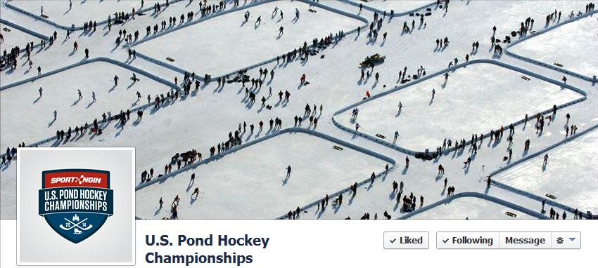
U.S. Pond Hockey Championships
In what is becoming a very popular tradition every January in the Twin Cities, the U.S. Pond Hockey Championships will be once again played at Lake Nokomis this weekend.
More more from the their Facebook Page HERE:
See more on their website HERE:
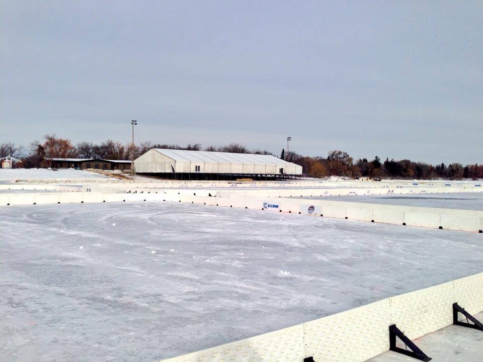
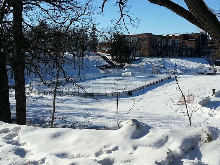
Hockey Day in Minnesota
Another one of my favorite days in Minnesota is Hockey Day in Minnesota, which is also this weekend! Elk River will be host to Hockey Day in Minnesota this year. Here's a picture of the outdoor rink where several high school teams will be playing to kick off the day: Saturday, January 18th:
(Photo courtesy @PoweredByHockey)
Follow on Twitter HERE:
Hockey City Classic
There will another outdoor hockey game this Friday evening at the TCF Bank Stadium - OUTDOORS. This time college hockey. Both the MN Golden Gophers men and women's will be playing in the Hockey City Classic. Weather will be a factor!
See more from MyGopherSports.com HERE:

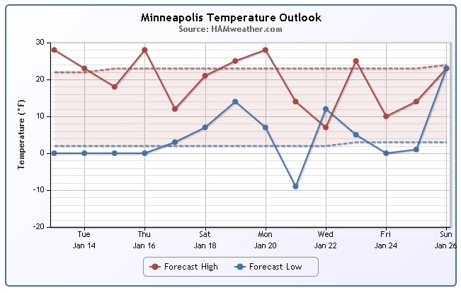
Minneapolis Temperature Trend
After mild Sunday, temperatures will take a bit of a nosedive this week as each passing clipper system tugs down some colder Canadian air. Here's the temperature trend for the Minneapolis area, which shows a bit of a temperature roller coaster this week. Note that overnight lows hover around the 0F; with gusty winds, sub-zero wind chill values will once again creep back into play at times this week.
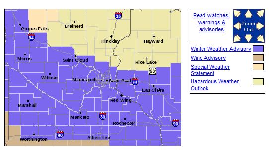
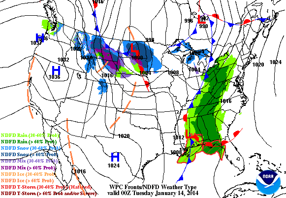
Winter Weather Advisory
...LIGHT SNOW DEVELOPING...BRIEFLY HEAVY AT TIMES OVERNIGHT...
A BAND OF LIGHT SNOW REMAINS ON TRACK TO DEVELOP ACROSS WEST CENTRAL AND CENTRAL MINNESOTA EARLY THIS EVENING...AND SPREAD EASTWARD ACROSS EAST CENTRAL MINNESOTA AND INTO WEST CENTRAL WISCONSIN BY MIDNIGHT. SOME SLEET...LIGHT RAIN OR LIGHT FREEZING RAIN IS POSSIBLE IN SOUTHWEST AND SOUTH CENTRAL MINNESOTA LEADING TO LOWER SNOWFALL TOTALS.
SNOW ACCUMULATIONS FROM 2 TO 4 INCHES ARE EXPECTED ACROSS PARTS OF CENTRAL...EAST CENTRAL MINNESOTA AND WEST CENTRAL WISCONSIN BEFORE THE SNOW TAPERS OFF TUESDAY MORNING. LESSER SNOWFALL TOTALS ARE EXPECTED ALONG THE MINNESOTA RIVER VALLEY.
STRONG NORTHWEST WINDS WILL DEVELOP BEHIND THIS SYSTEM OVERNIGHT AND CREATE BLOWING AND DRIFTING SNOW...ESPECIALLY IN OPEN COUNTRY. A WINTER WEATHER ADVISORY REMAINS IN EFFECT FOR AREAS GENERALLY ALONG AND SOUTH OF INTERSTATE 94.
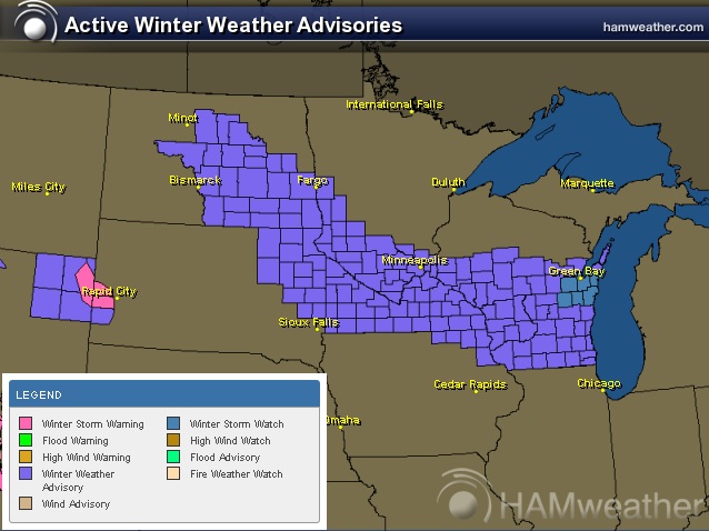
Winter Weather Concerns
The National Weather Service continues winter weather headlines from the Dakotas to the Great Lakes Region through PM Tuesday.
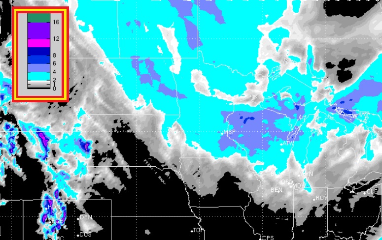
Midwest Snow Potential
Here's the Midwest snow potential from AM Monday - AM Thursday, which includes two clippers through midweek. The biggest snow threat moves through the Midwest PM Monday - PM Tuesday.
Clipper-Fest Returns
Now that the extremely cold weather has subsided a bit, the storm track has lifted a little farther north. This will allow several clipper systems to roll through the Midwest/Great Lakes Region over the coming days; each one posing a threat for light snow accumulations, strong winds and a sharp temp drop. The loop below shows 2 such systems moving through the Upper Midwest/Great Lakes through Wednesday.
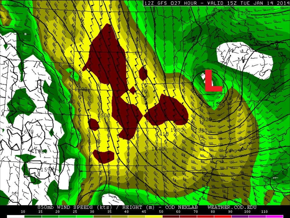
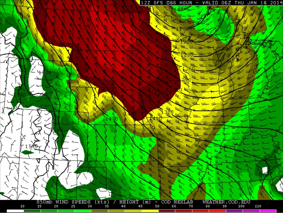
Blowing Snow Potential
Keep in mind that fresh snow will be blowing around quite a bit with strong winds on the backside of each passing clipper this week. Here are the wind fields surrounding the two clipper systems this week.
AM Tuesday
Winds a few thousand feet off the ground by Tuesday morning look quite impressive as this first clipper system rolls through. As the strong wind mixes down to the surface, all of our fresh snow from clipper #1 will likely be blowing around making for some difficult traveling, especially in rural areas.
PM Wednesday/AM Thursday
Here's our secondary clipper system set to move through the Midwest by midweek. The wind field surrounding this one looks even more impressive, which could lead to even more blowing snow issues across the Dakotas into parts of Minnesota and eventually into Wisconsin through the day Thursday.
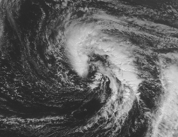
Subtropical Storm Arthur?
WOW! How about this... as of early Monday, there was a storm brewing east of Bermuda that could intensify enough to become the first named storm of 2014 in the Atlantic basin! Weird huh?
Thanks to the Capital Weather Gange for the info below:
"On average, about 97% of tropical cyclone activity falls within the official hurricane season, while the remaining 3% is spread out among the six off-season months. Looking back to 1851, only two known storms have formed during January: Hurricane #1 in 1938 (formed January 3), and Subtropical Storm #1 in 1978 (formed on January 18)."
Read more from the WashingtonPost.com HERE:
More on the Arctic Blast Last Week
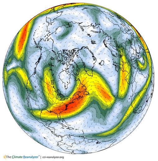
The main reason for the extreme temperature dip in the eastern part of the country was because of a large dip in the jet stream or strong upper level wind. The jet stream typically blows from west to east in the northern hemisphere with little kinks in it here and there. Every so often there will be a big kink in that wind field, which sends warm air north or cold air south depending on the direction of the kink. Take a look in the large dip in the jet stream across the eastern U.S. last week. This resulted in a significant drop in temps, one that brought record cold to places as far south as the Gulf Coast States.
See the current atmosphere HERE:
Jet Stream From January 7th, 2014
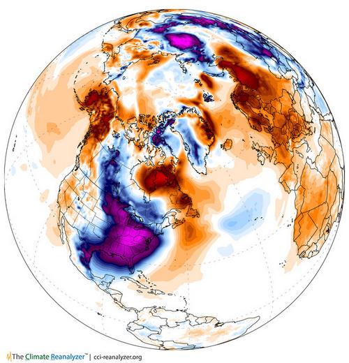
Temperature Anomaly From January 7th, 2014
The large purple blob over the eastern U.S. suggests WELL below normal temperatures for that date.
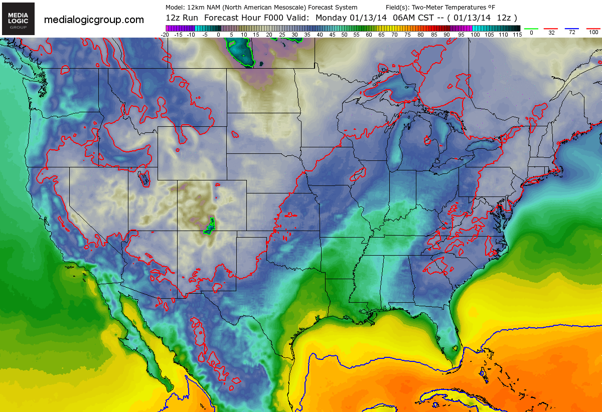
FutureTemps
Falling temperature are expected this week as several impulses of energy slide into the Midwest. The good news is that it doesn't look nearly as cold as it was last week.
Cooler By Wednesday
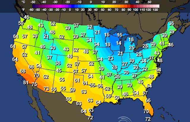
High temperatures across the eastern half the nation look quite a bit cooler than earlier this week. It's interesting to see the nation so divided. The western part of the country looks to remain well above normal while the eastern part of the country will be cooler than average.
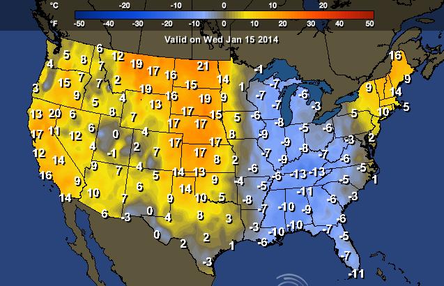
Highs Wednesday
Note also how warm temps look to be in the southwestern part of the country by midweek! 80s can't be ruled out for folks in southwestern California!
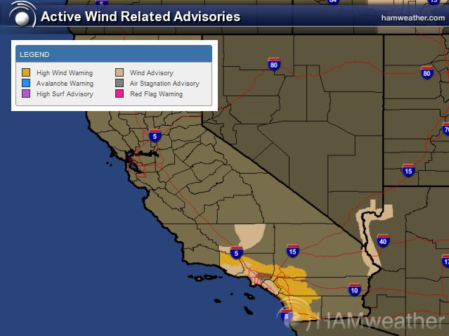
Santa Ana Winds
Another Santa Ana wind event is underway. Due to an area of high pressure across the western part of the country, strong winds will gust up close to 50mph to 60mph through midday Wednesday. Not only will these be warm winds, but they will also be dry winds. With the current dry situation across California, fire danger will be an issue too!
Thanks for checking in and have a great week ahead! Don't forget to follow me on Twitter @TNelsonWNTV

No comments:
Post a Comment