By Todd Nelson
I felt like Old Mother Hubbard this week, looking through the mostly bare fridge and cupboards. I needed to do a little shopping to replenish the quick bites; I was getting pretty creative slapping meals together for the family since I didn't want to brave the extreme cold. Well, I ventured out yesterday and was tagged with a hefty grocery bill, but I also overheard some folks chatting that they've finally come out of hibernation. I guess I wasn't alone.
Now that the upper level winds and become more "Zonal" or straight from the Pacific, we're all enjoying a non nose tingling air mass. Hey, you might actually see your neighbors today!
Take advantage of the 'warmer' weather this weekend. Shovel a few bare spots on the driveway or sidewalk and let some of the midday sun do a little of the work for you. Head to the gas station, get a car wash and blast some of the salty chemicals off the car. Find a good radio station, though, as the lines could be quite LONG!
Clipper systems return next week with light precipitation chances. We play temperature limbo as they approach and breeze by. Colder winds return by the end of next week and maybe even a sub-zero night.
______________________________________________________________
FRIDAY NIGHT: Light snow potential early, gradual clearing later. Low: 17. Winds: W 5.
SATURDAY: Neighbors emerge from homes! Feeling much better. High: 29. Winds: WNW 10.
SATURDAY NIGHT: Partly cloudy and quiet. Low: 19. Winds: WSW 5-10
SUNDAY: Warm January day. Partly sunny. High: 37. SW 10
MONDAY: Back to work. Breezy and cooler. Wake-up: 10. High: 20.
TUESDAY: A few flakes? Nothing rough. Wake-up: 10. High: 22.
WEDNESDAY: More clouds, light mix up north. Wake-up: 7. High: 23.
THURSDAY: Cold winds return with light snow.. Wake-up: 15. High: 17
FRIDAY: Sub-zero AM wind chills. Cold sun. Wake-up: 0. High: 15.
_____________________________________________________________
This Day in Weather History
January 11th
1975: Blizzard continues with hurricane force winds in southwestern Minnesota.
1899: An odd flash of lightning lit the clouds up around 9 pm at Maple Plain.
______________________________________________________________
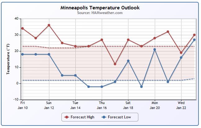
Temperature Trend
Ahh, now this is more like it! Sure feels nice after such a cold week last week, doesn't it? Temperatures look to remain mild over the next few days, but a slight cool down is expected next week with the threat of some sub-zero nights. Stay tuned.
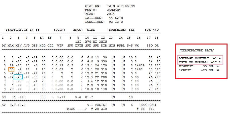
Cold Start to January
Here's the Minneapolis weather data through the first 9 days of the month - note the average temperature is SUB-ZERO, while the departure from normal temperatures were running nearly -17F below average! YIKES!! The warmest reading during that period was 35F on the 4th, while the coldest reading was -23F on the 6th.
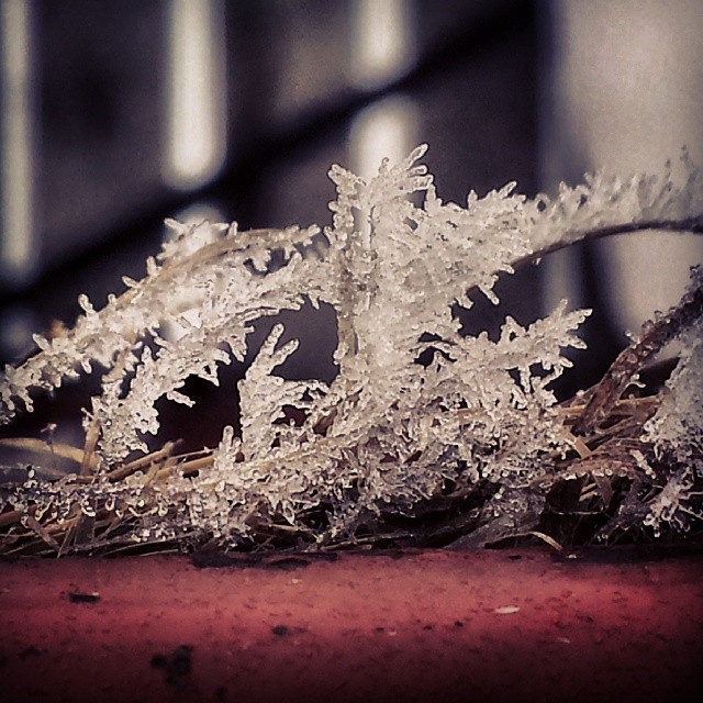
Icy Friday
A transition from colder air to warmer air unfortunately created icy situations in many spots across the country on Friday. Here are some images from Friday.
Neillsville, WI
Thanks to my good friend, Matt Dux for the picture below who said fog and freezing drizzle created some pretty scenes.
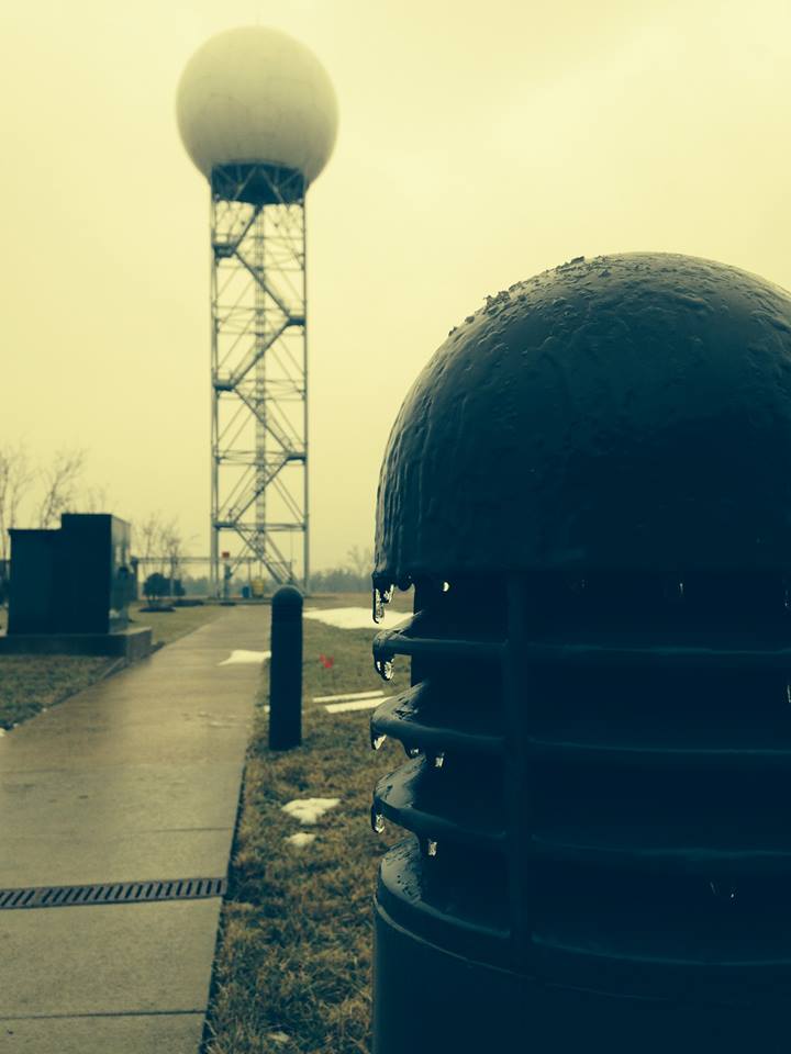
Icy Friday in Our Nation's Capital
Thanks to the National Weather Service out of Washington D.C./Baltimore for the picture below. They measured 0.07" of ice Friday morning when this picture was taken.
What Come Around Goes Around
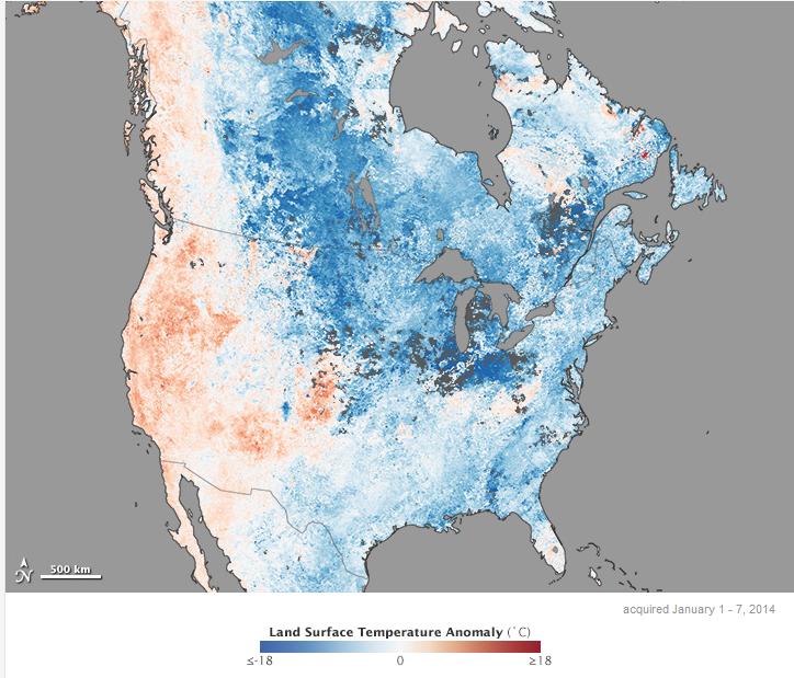
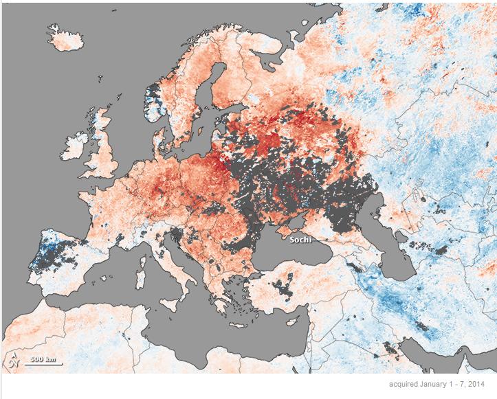
Here's a pretty interesting article from EarthObservatory.NASA.gov - which describes the great variability in weather from region to region. Early January was a great example of how extreme the differences were from North America to Europe. The findings may be pretty surprising!
"In early 2014, temperature patterns in the northern hemisphere offered a good example of how the atmosphere can simultaneously produce starkly contrasting weather extremes. In North America, a swirling mass of Arctic air moved south and brought extremely cold temperatures—and much discussion of the polar vortex. At the same time, Europe faced a stretch of unusually warm weather that made holiday celebrations rainy rather than snowy and prompted discussions about whether there will be enough snow for the upcoming winter Olympics in Sochi, Russia.
The top map above shows land surface temperature anomalies in North America for January 1–7, 2014. Based on data from the Moderate Resolution Imaging Spectroradiometer (MODIS) on NASA’s Terra satellite, the map depicts temperatures for that period compared to the 2001–2010 average for the same week. Areas with warmer than average temperatures are shown in red; near-normal temperatures are white; and areas that were cooler than the base period are blue. Gray indicates areas where clouds blocked the satellite from collecting usable data. The second map, based on the same MODIS data, shows temperature anomalies in Europe for the same period."
Read the full article HERE:
Mild Saturday Ahead!
Good news for folks that aren't fans of the extreme cold... Saturday's high temperatures looks MUCH warmer than what we had earlier this week! In some cases, we'll be nearly 50F+ warmer than Tuesday's morning low temperatures.
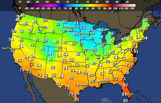
This is how warm it'll be compared to average on Saturday!
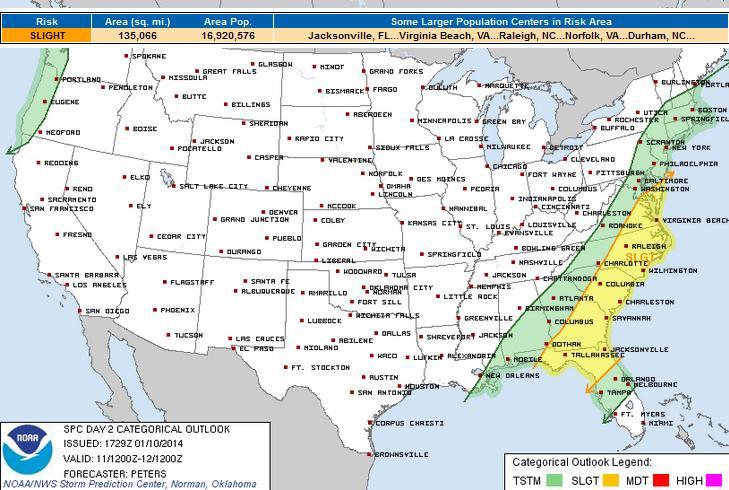
Saturday Severe Threat
A cold front plowing through the eastern half of the nation on Saturday will help to some unsettled weather conditions for some folks in the southeastern corner of the nation. The Storm Prediction Center has issued a SLIGHT RISK of severe weather for areas near the Delmarva Peninsula to parts of northern Florida.
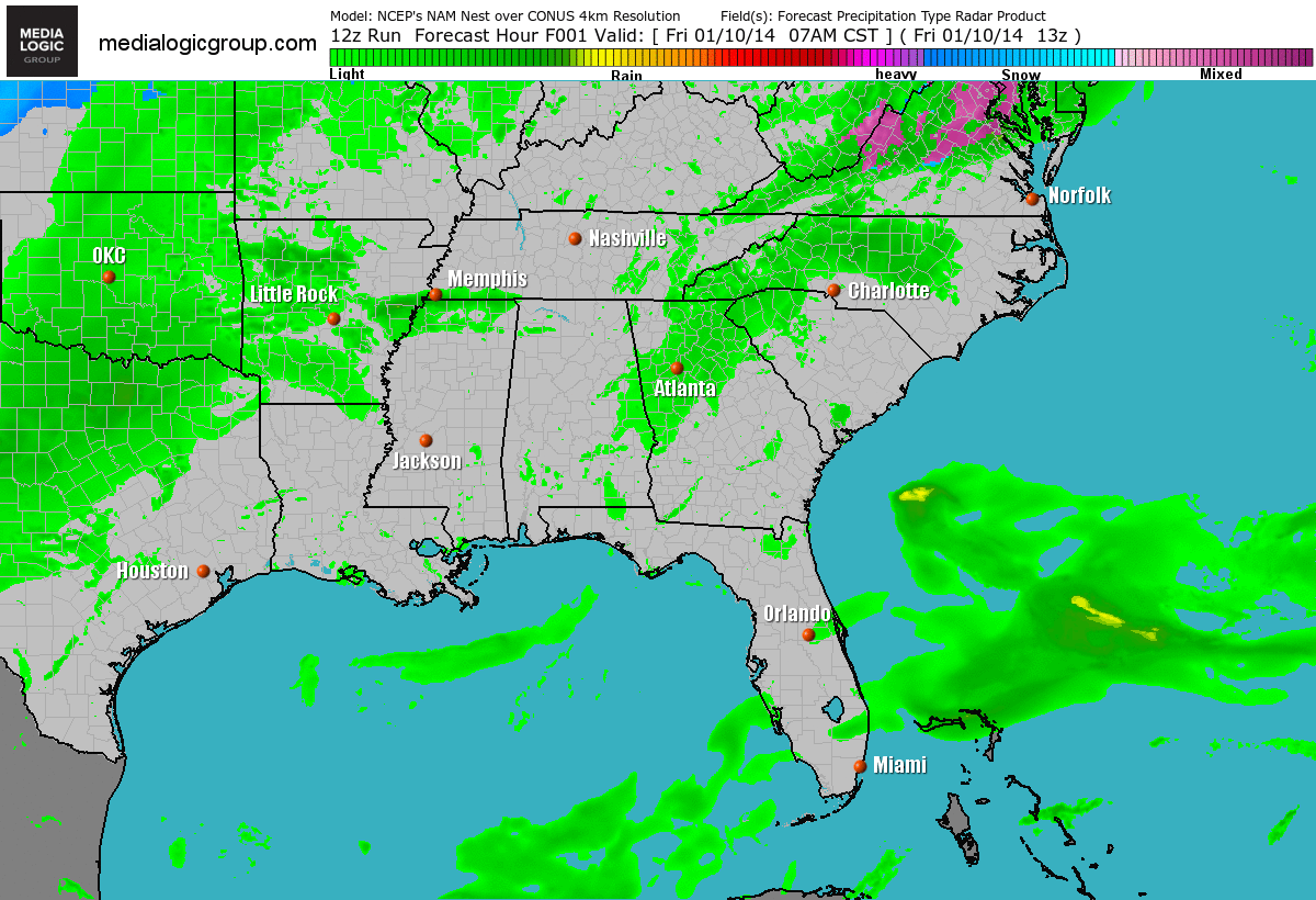
Saturday FutureCast
Here's a look at the simulated radar as the cold front plows east with shower and thunderstorm potential. It appears to be a fairly quick hitting system that brings a severe threat and heavy rain. Sunday the front pushes east into the Atlantic, so Sunday looks to be the pick day of the weekend to get out and about!
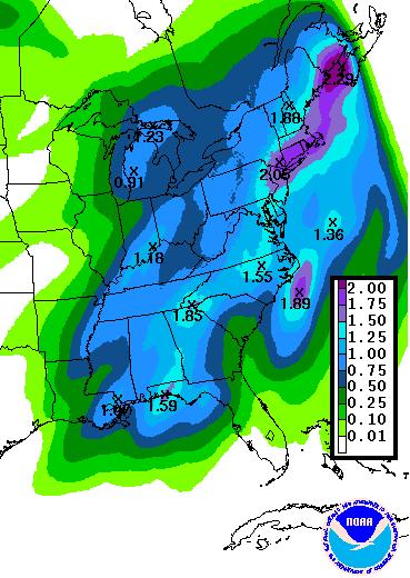
More Heavy Rain on the Way
According to NOAA's HPC 2 day precipitation forecast, there's still quite a bit of additional moisture that will be rolling through the eastern part of the country this weekend. As much as 1" to 2"+ may be possible in spots. Some of the heaviest precipitation this weekend may be found across parts of the Northeast, where flooding can't be ruled out.
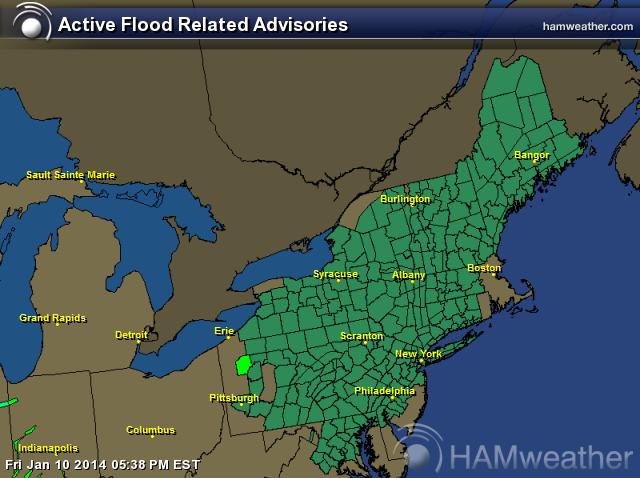
Flooding Concerns
As warmer temperatures and heavier rainfall begin to move through the area this weekend, flooding is going to become an issue. There are already reports of ice jams along local rivers, streams and creeks. The additional weekend elements may help to invigorate some of these concerns, thus the widespread flood watches through PM Sunday.
* FROM SATURDAY AFTERNOON THROUGH SUNDAY EVENING
* RAIN WILL MOVE IN SATURDAY MORNING AND END SATURDAY EVENING. THIS RAIN COMBINED WITH HIGH TEMPERATURES IN THE LOWER 50S WILL CAUSE THE SNOW TO MELT. RAINFALL AMOUNTS WILL BE UP TO ONE AND A HALF INCHES FROM SCRANTON EAST TO THE POCONOS AND SOUTHERN CATSKILLS. THE REST OF THE AREA WILL GET AROUND HALF AN INCH. SNOWMELT WILL ADD LESS THAN AN ADDITIONAL INCH OF LIQUID. THE RAIN AND SNOWMELT COULD BE ENOUGH TO CAUSE ICE ON THE RIVERS AND STREAMS TO LIFT AND CAUSE JAMS. IN ADDITIONAL A FEW HEADWATER RIVER POINTS IN THE DELAWARE RIVER BASIN COULD RISE TO FLOOD STAGE CAUSING MINOR FLOODING.
* ICE JAMS ARE ALREADY PRESENT ACROSS THE AREA. INCREASED RUNOFF FROM THE RAIN AND MELTING SNOW COULD CAUSE MORE WATER TO BACK UP AND POSSIBLY RESULT IN MINOR FLOODING.
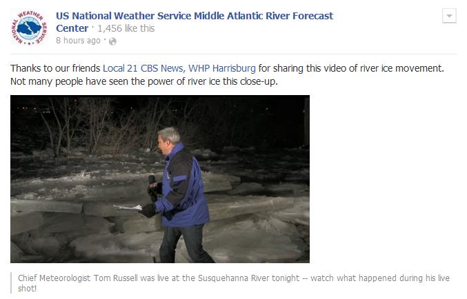
Ice Jam Threat
Here's a great example of what an ice jam looks like - not only is there a real danger from the ice itself, but the secondary threat is flooding. Thanks to the National Weather Service Middle Atlantic River Forecast Center for sharing this on their Facebook page via Local 21 News, WHP Harrisburg.
See the full video HERE:
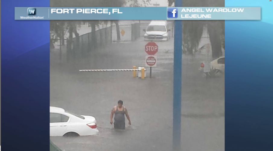
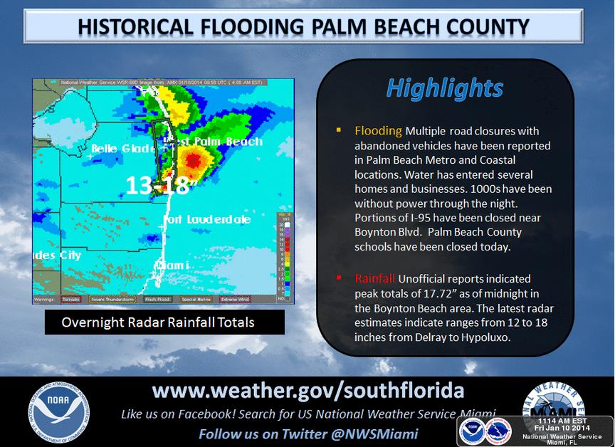
Record Florida Rainfall
Look at this incredible image from Fort Pierce, FL where record rains caused some major flooding. Notice how deep the water is! YIKES!
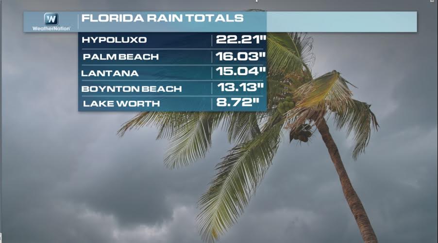
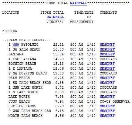
Insane Rain Totals
These are some of the insane rain tallies reported by the National Weather Service out of Miami, FL - good grief!
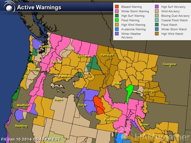
A Mess in the Pacific Northwest
The map below describes it best... A mixed bag of watches, warnings and advisories from wind to snow to flooding; there's a lot going on as several Pacific storm system move inland. Some of these headlines actually stretch down into Colorado, which is not pictured below.
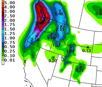
Weekend Precipitation in the Northwest
Here's NOAA's HPC weekend precipitation forecast. Note the heavy precipitation forecast for those in the higher elevations of the Olympics and the Cascades, where several inches of precipitation can't be ruled out by PM Sunday.
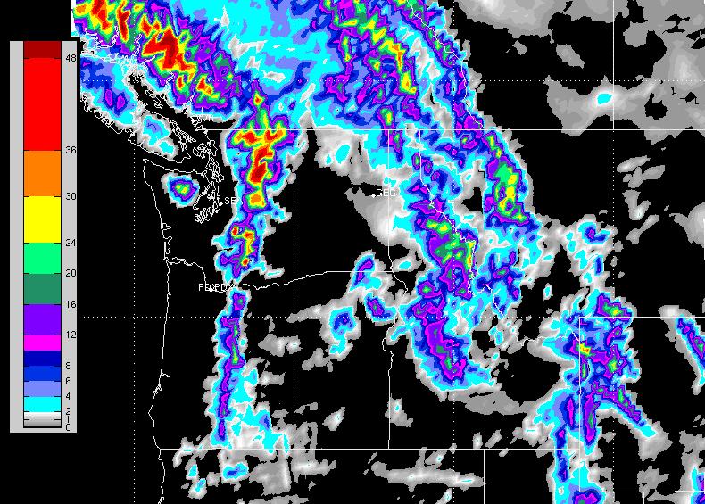
Northwest Snowfall Potential
Here's a look at the snowfall potential thru midday Monday, which shows some pretty substantial amounts possible in the mountains!
Thanks for checking in, have a great weekend ahead! Don't forget to check me out on Twitter @TNelsonWNTV

No comments:
Post a Comment