Dripping Icicles
By Todd Nelson
Today we celebrate the fact that 30s are in the forecast again.. What kind of sick and twisted reality are we living? Good grief! I got a text from a friend of mine who said she's was going to roll down the windows in the car today just because. Hey, why not.
Yes, we may all be a little delusional, disoriented and maybe even a little irrational after the latest Arctic blast, but at least we're still making the most of it. When you live in a cold climate, you have to embrace any and every small victory that comes your way!
The low temperature at the MSP Airport on Tuesday morning was -23F, the high today could even sneak up close to 40F in spots across southern Minnesota. Not only is that at 50F to near 60F temperature swing in just a matter of days, but it'll also be the warmest we've been since December 28th when the mercury topped out at 47F. Do you remember that record high? I know, I forgot too.
Several rounds of Pacific moisture wiggle our way over the next 5 to 7 days. Each one will bring a quick shot of colder air and precipitation chances. A sharp cool down is in order later this week. Sub-zero wind chills return PM Wednesday into Thursday - Oh goodie'
________________________________________________________________
SATURDAY NIGHT: Mostly cloudy and quiet. Low: 20. Winds: WSW 5-10
SUNDAY: Warm January day. Mostly cloudy with a few afternoon sprinkles? Light wintry mix up north. High: 39. SW 10-15
SUNDAY NIGHT: Partial clearing, turning colder. Low: 17 Winds: WSW 5-15
MONDAY: Back to work. Breezy and cooler. Another clipper arrives late/overnight, snow develops. High: 18.
TUESDAY: A few flakes early. Cold winds. Wake-up: 10. High: 19.
WEDNESDAY: More clouds, light mix up north later. Wake-up: 1. High: 19.
THURSDAY: Dropping temps with a few wind blown flakes. Wake-up: 16. High: 25 (falling thru the day)
FRIDAY: Sub-zero AM wind chills. Cold sun. Wake-up: 2. High: 12.
SATURDAY: Cold start. Mostly sunny, feeling better by the afternoon. Wake-up: 1. High: 20
_______________________________________________________________________
This Day in Weather History
January 12th
2000: Snow falls in a narrow band over the Twin Cities. Maplewood receives 5.5 inches, while Chanhassen gets 12.
1888: "Blizzard of '88." It hit during a mild day when many children were heading home from school. They made up the majority of the 200 people that died. At the end of the storm the thermometer at St. Paul read -37.
______________________________________________________________________
National WHAT Day?
January 12th
National Marzipan Day
National Pharmacist Day
National Stick to Your New Year's Resolution Day
______________________________________________________________________
This Day in History
January 12th
*Haiti earthquake kills nearly 220,000 (2010)
"“I continue to call on the international community to stand with Haiti at its time of dire need. We must intensify our efforts to help Haiti build a more stable and prosperous future for the all its people. Let us renew today our pledge to follow our fallen colleagues’ dream of a life of dignity for all the people of Haiti.” The massive quake which struck Haiti on 12 January, 2010, killed some 220,000 people, including 102 UN staff, made 1.5 million others homeless, and caused widespread destruction and a major humanitarian crisis."
(photo courtesy: Logan Abassi/MINUSTAH)

Temperature Trend
WOW! Look at that high temperature for Sunday! Mid to upper 30s will feel great, especially after the painfully polar air we endured earlier this week. From the lowest temperature on AM Tuesday of -23F to the high temperature in the mid to upper 30s on Sunday; that's a near 50F to 60F temperature swing in just a few days! A larger 'clipper' will help to cool things off a bit later this week. High temperatures will get tugged down into the lower to middle teens, while the overnight lows could once again head back down into the sub-zero range.
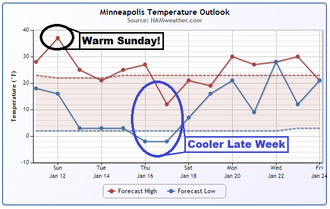
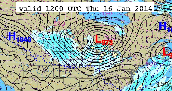
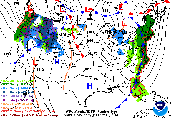
Turning Colder Late Next Week
A stronger clipper/hybrid Pacific storm will whip up a pretty decent and much colder wind by the middle/end of next week. Here's the storm forecast by AM Thursday, which shows post cold front conditions through the Upper Midwest. A blustery and much colder wind is expected then.
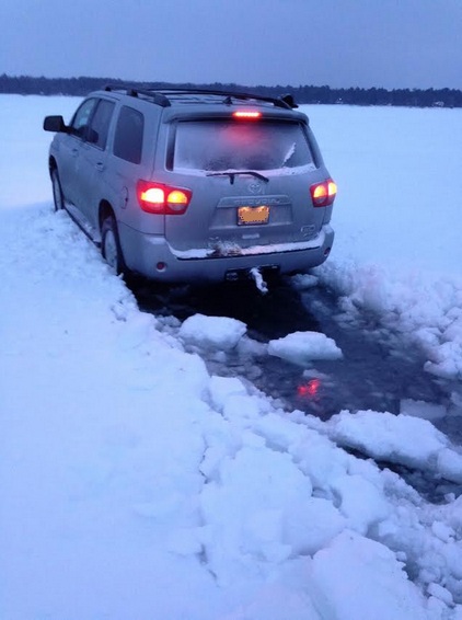
Slushy Ice
Thanks to my good friend, Drew Novak for the picture below who was on Round Lake in Brainerd, MN last weekend and encountered a very slushy pressure ridge. He is an avid angler and tells me that ice conditions this year are extremely slushy (somewhat rare) due to all the snow we had early in the ice making season. There was a crack in the ice and due to the weight of the snow, the water was seeping up through the crack, so they got stuck for a short time. Thanks for passing this pic along Drew!
(photo courtesy: Drew Novak)
Latest Ice Reports
Thanks to Drew for turning me onto this website, which is a forum style website that folks update frequently about ice conditions in their area. Lots of info here from Minnesota and from around the region. Definitely a bookmark worthy!

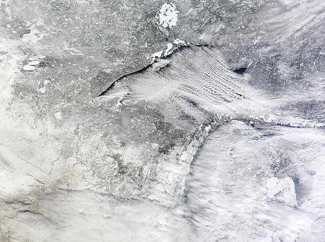
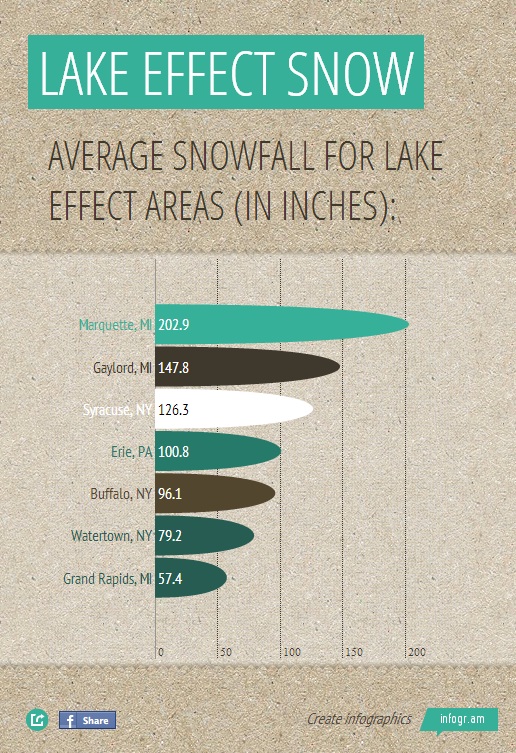
Lake Effect Snow
One of my favorite things to see from visible satellite is lake effect snow bands over the Great Lakes. Take a look at the image below from Tuesday, January 7th when some of the coldest air in nearly two decades was plowing through the eastern half of the country. The lake effect snow bands over Lake Superior look amazing! Note how far they stretch (fetch) - from the open waters just south of Canada to the U.P. of Michigan. Extreme lake effect snow events can produce near 3" to 4" snow rates per hour. One of the heaviest tallies reported from the extreme lake effect snow event earlier this week was out of Rodman, NY which is downwind of Lake Ontario. Rodman, NY picked up an amazing 60" over several days of heavy snow!
Interesting Snow Stats
According to NWS NOWData, here are some of the average annual snow tallies for some select lake effect snow cities in the Great Lakes Region.
Northern Lights?
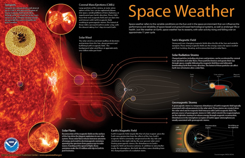
A highly anticipated CME was expected to bring northern lights across the northern latitudes earlier his week, but it turned out to be a bust! Why? NOAA explains that a weak magnetic field may be partially to blame.
"Forecasters at NOAA's Space Weather Prediction Center said the sun's coronal mass ejection (CME) that reached Earth on Jan. 9, unsettled the geomagnetic field but did not cause storm conditions to be reached due to the weak magnetic field. While there is still a chance we could see some geomagnetic storming that threat is greatly diminished.
The sunspot in Region 1944 that produced the eruption at 1:32 p.m. EST Tuesday, Jan. 7 has had no significant additional flaring and shows signs of decay."
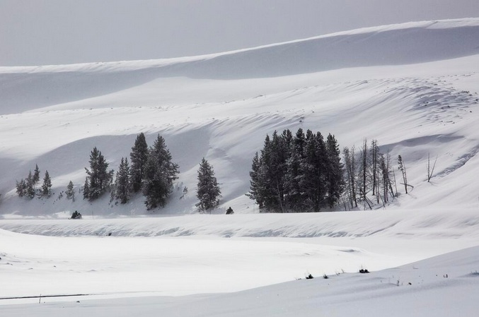
Sea of Snow
Thanks to the Yellowstone National Park Service for sharing this picture on their Facebook Page of their recent snowy scenes. Several round of Pacific moisture continue to slide through the region with high winds and heavy snow. It appears that snow chances will continue into early next week for folks in that region. The picture below is from Hayden Valley.
(photo courtesy: Yellowstone National Park Service)
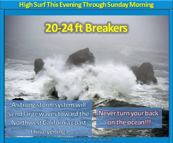
HUGE Swells in the Pacific Northwest
The National Weather Service out of Eureka, CA is warning of HUGE swells along the Pacific Northwest coastline as another large storm slaps the West Coast.
Western Mess
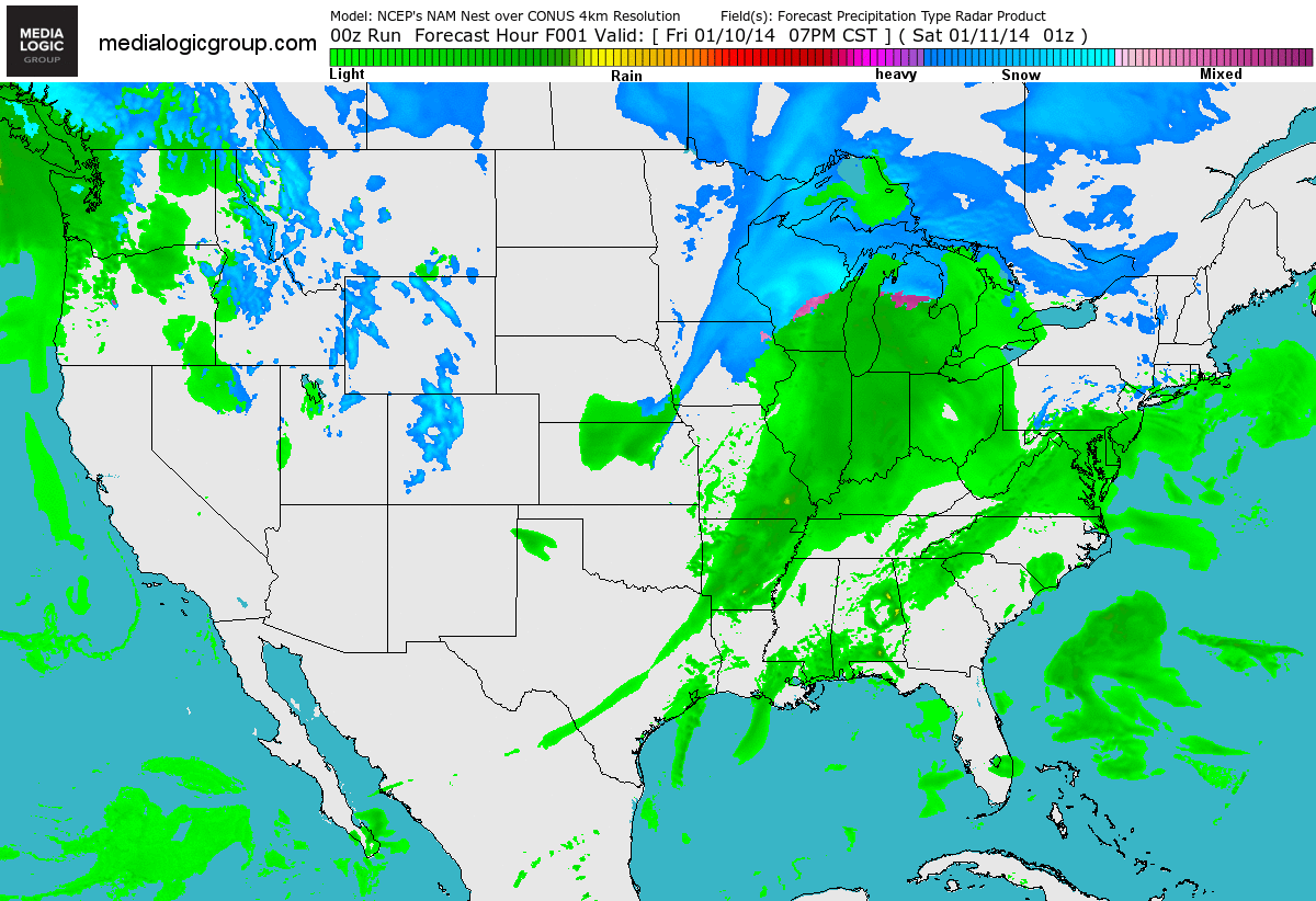
YIKES! Thanks to several Pacific storm systems, the weather part of the country continues to take a beating. From flooding to high winds to flooding rain to heavy snow and avalanche potential, there's a lot going on.
Parade of Pacific Storms
A series of Pacific storms will continue to dump copious amounts of moisture in the western part of the country. Heavy rain in the lower elevation/coastal communities, while heavy snow and avalanche potential is expected in the higher elevations.
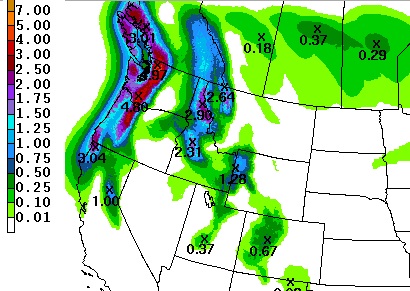
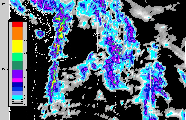
Northwest Weekend Precipitation
By early Monday morning, there could already be several inches accumulated precipitation across some of these areas, especially in the higher elevations of the Cascades and the Olympics. According to NOAA's HPC 2 day precipitation forecast from AM Saturday to AM Monday, there could be totals nearing 5" amounts!
Heavy Mountain Snow
The snowfall forecast from AM Saturday to AM Monday looks quite impressive for the higher elevations. Total weekend tallies certainly could be measured in feet in some of the more extreme cases!
Saturday Severe
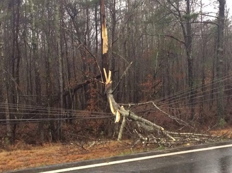
A line of strong to severe thunderstorms rumbled across the southeastern part of the country on Saturday with a number of wind damage reports. Here's a picture from @dwjga near the Canton, GA area. There were quite a few reports of downed trees and power lines on Saturday as the squall line raced east.
(photo courtesy: @dwjga)
Here's another damage picture, this one is from @thrillis4 out of Raleigh, NC. There was even an 86mph wind gust reported at the Raleigh-Durham International Airport as the squall line blasted through.
This was the METAR report from the airport. I've highlighted the peak wind report, which states that at 1857 local time (1:57pm EST) there was a peak wind of 75knots (86mph) from 220° (from the SW).
KRDU 111859Z 24045G75KT 7SM -RA SQ SCT019 BKN029 OVC070 18/17 A2964 RMK AO2 PK WND 22075/1857 PRESRR P0000
(photo courtesy: @thrillis4)
Saturday Storm Reports
As of midday Saturday, there had already been nearly 70 storm reports in the southeastern part of the country. Most of the reports were related to straight line winds. There were numerous reports of downed trees and power lines.
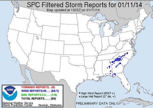
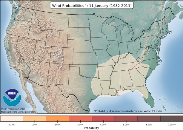
Severe Weather Probability for January 11th
Now you typically don't see a ton of severe weather in the month of January, but it's not unprecedented. However, according to the SPC, the damaging wind probability is pretty low; around 1% from parts of the Ohio Valley on south to the Gulf Coast.
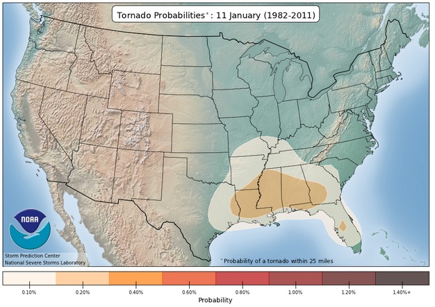
This is the tornado probability for January 11, which is even lower; less than 1%!
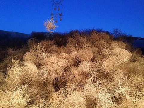
Piling Up in Albuquerque?
WOW! Can't say I've ever seen a pile up like this one before... Thanks to @KRQEMark (Mark Ronchetti) for this wild picture out of Albuquerque, NW who says:
"It's really starting to pile up on the #ABQ metro westside. What? Oh, you were expecting snow? #nmwx #drought pic.twitter.com/FrjcjXZdHw"
What do you do with all those tumbleweeds?
Thanks for checking in and have a great rest of your weekend. Don't forget to follow me on Twitter @TNelsonWNTV

No comments:
Post a Comment