By Todd Nelson
I feel a little like Bill Murray from the movie Groundhog Day... I'm running out of creative adjectives to describe our cold and snowy weather as of late. It is literally a broken record. Nearly a copy and paste forecast into the next several days.
While we continue to endure traditional wintry weather here in the eastern half of the country, the western half of the country continues their dry ways. 2013 was considered the driest year on record for California. Water shortages in the state are becoming increasingly more worrisome as we continue through this very dry 'wet season'. Sacramento, CA will likely tie a record today with 46 consecutive days of no precipitation! Mormon Island, an old gold prospecting town from the 1800s has emerged from Folsom Lake after being submerged for nearly 60 years!
Unfortunately, I don't see this weather pattern breaking down anytime soon. A large lobe of cold air looks to continue to wobble down into the Lower 48 through the end of January. The persistent northwest flow will tug down small clipper systems; one almost every other day through early next week with light snow chances.
Breaking news... it's winter! -Todd Nelson
____________________________________________________
TUESDAY NIGHT: Clouds increase with a coating up to 1" snow - slick roads. Low: -2. Feels Like: -15F
WEDNESDAY: Mostly cloudy with lingering flurries early. Reinforcing shot of cold air. High: 3. Winds: NW 10-15. Feels Like: -25F
WEDNESDAY NIGHT: Partly cloudy and COLD!. Low: -13. Feels Like: -30F
THURSDAY: May I be excused? Blue sky. Numb. High: 0.
FRIDAY:Another clipper, more fluffy snow. Wake-up: -2. High: 26
SATURDAY: A few flakes? Turning colder. Wake-up: 17. High: 18
SUNDAY: Peeks of sun, still cold. Wake-up: 0. High: 11.
MONDAY: Character-building. Feels like -30F. Wake-up: -8. High: 3.
TUESDAY: More Arctic sunshine. Wake-up: -4. High: 8.
_____________________________________________________
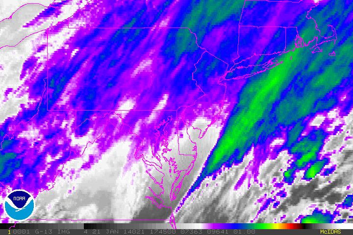
Tuesday Snowstorm
A quick hitting snowstorm from the Ohio Valley to the Northeast was visible on a NOAA satellite Tuesday afternoon. Note the brighter blue colors from parts of Virginia to eastern PA, southern NY and Mass. This is where some of the heaviest snow through late afternoon Tuesday had piled up.
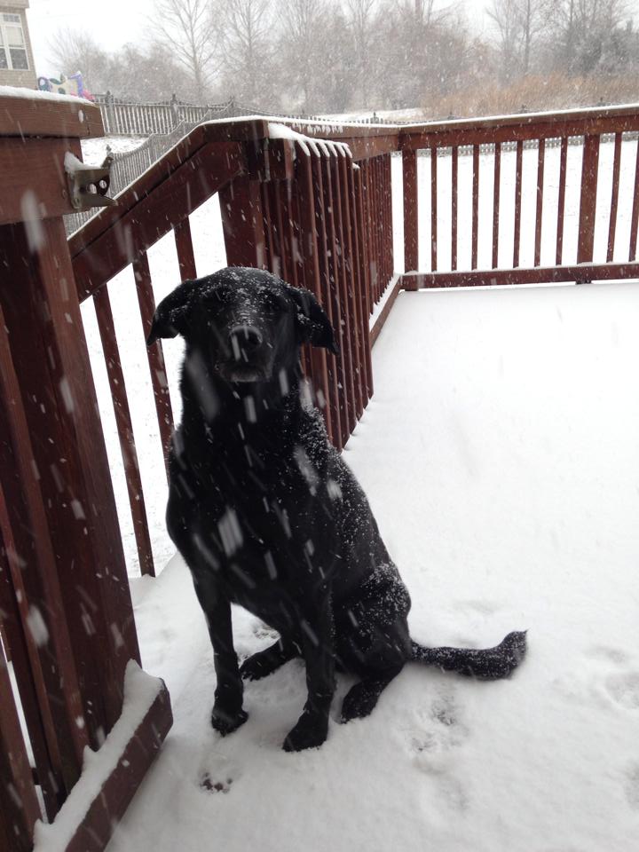
Snow Dog
Thanks to my good friend Amy Bettwy for this picture out of Darnestown, MD where the snow piled up on Tuesday. A quick hitting winter storm took aim on locations from the Ohio Valley to the Eastern Seaboard.
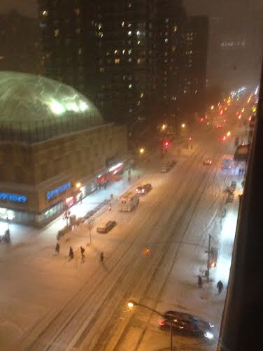
Snowy NYC
Thanks to my good friend Jamie Steinert for this shot out of NYC on Tuesday evening. He said that 8th street about 6 blocks south of the Madison Square Garden is usually packed at the time of this photo, but it was pretty quite with the storm. The only cars that seemed to frequent the area were food delivery cars!
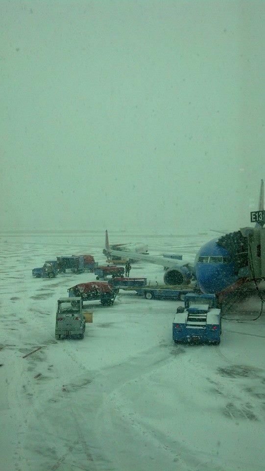
Here's another snowy shot from Eric Champagne who was at the Philadelphia, PA airport on Tuesday.
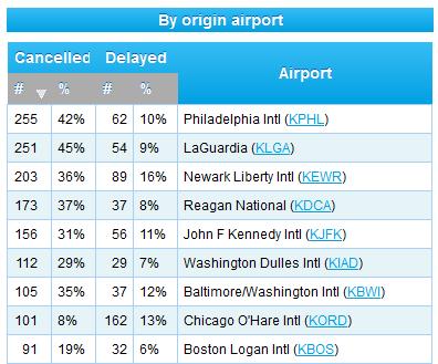
Tuesday Cancellations or Delays
According to FlightAware.com, there were nearly 2,000 flights either cancelled or delayed on Tuesday from some of the major hubs in the eastern U.S. - Chicago made the list too as heavy snowfall moved through AM Tuesday.
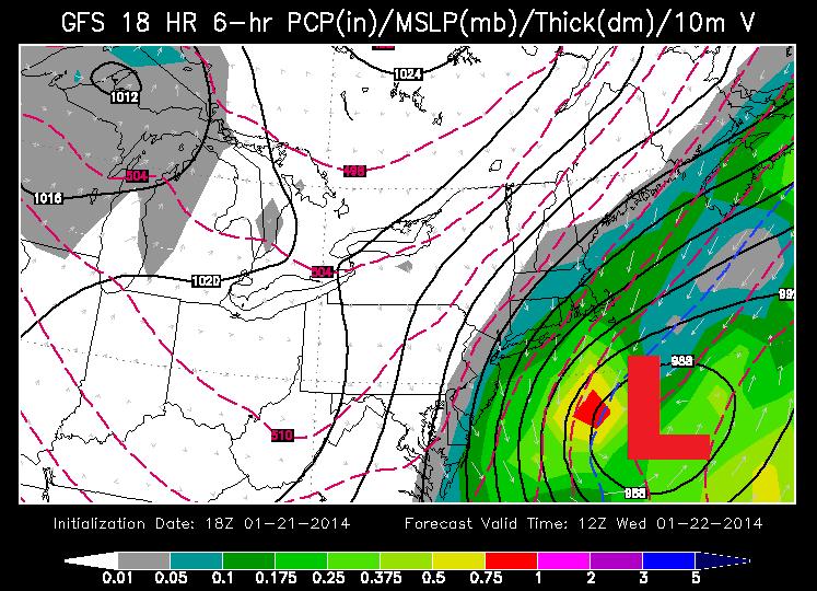
Eastern Storm Moves Out Wednesday
The storm that impacted the eastern U.S. on Tuesday will quickly pull away from the Eastern Seaboard on Wednesday. Windy conditions will persist through the early portions of Wednesday, but MUCH colder air will be secondary threat to this particular system.
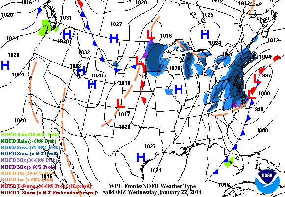
Blizzard Potential
The East Coast storm looks to continue to strengthen into early Wednesday as it moves offshore . Heavy snow and intense winds will be found on the northern/northwestern flank of the low pressure system. Here's the forecast placement by AM Wednesday.
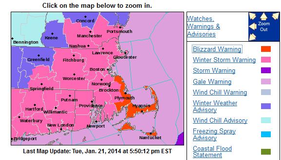
The National Weather Service continues Blizzard Warning for the southeastern corner of Mass. until PM Wednesday.
Here's more information from the National Weather Service out of Boston, MA:
...BLIZZARD WARNING REMAINS IN EFFECT FROM 7 PM THIS EVENING TO 1 PM EST WEDNESDAY...
* LOCATIONS...COASTAL PLYMOUTH COUNTY...CAPE COD AND THE ISLANDS. * HAZARD TYPES...HEAVY SNOW AND BLIZZARD CONDITIONS.
* ACCUMULATIONS...8 TO 14 INCHES.
* TIMING...SNOWFALL RATES OF 1 TO 2 INCHES PER HOUR ARE LIKELY AT TIMES PM TUES.
* IMPACTS...TRAVEL WILL BECOME MORE DIFFICULT BY THE EVENING COMMUTE...AND ESPECIALLY TONIGHT INTO WEDNESDAY MORNING WHEN NEAR WHITEOUT CONDITIONS ARE EXPECTED AT TIMES.
* WINDS...NORTH 20 TO 30 MPH WITH GUSTS UP TO 50 MPH.
* VISIBILITIES...BELOW ONE QUARTER MILE AT TIMES.
_____________________________________________________________________________
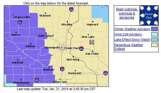
...WINTER WEATHER ADVISORY IN EFFECT FROM 3 AM TO 6 PM CST WEDNESDAY...
...STRONG NORTHWEST WINDS TO BRING BLOWING SNOW AND DANGEROUS WIND CHILLS LATE TONIGHT AND WEDNESDAY ACROSS WEST AND SOUTH CENTRAL MINNESOTA...
NORTHWEST WINDS WILL INCREASE TO SPEEDS OF 20 TO 35 MPH AND LEAD TO BLOWING SNOW OVERNIGHT AND WEDNESDAY...ALONG WITH WIND CHILLS FROM 20 BELOW TO 35 BELOW. A WINTER WEATHER ADVISORY IS IN EFFECT FROM 3 AM TO 6 PM WEDNESDAY...GENERALLY WEST OF A ST CLOUD TO GLENCOE TO KIESTER LINE. VISIBILITIES WILL BE LIMITED DUE TO THE STRONG WINDS BLOWING SNOW AROUND...ESPECIALLY IN OPEN AREAS.
* TIMING: STRONG NORTHWEST WINDS WILL CAUSE BLOWING SNOW TO DEVELOP OVERNIGHT AND PERSIST THROUGH WEDNESDAY.
* MAIN IMPACT: REDUCED VISIBILITIES DUE TO BLOWING SNOW.
* OTHER IMPACTS: WIND CHILLS OF 20 BELOW TO 35 BELOW ON WEDNESDAY.
Light Snow Through AM Wednesday
A quick moving clipper will move through the Upper Midwest from PM Tuesday - AM Wednesday. This particular system won't have a terrible amount of precipitation with it, so snowfall amount are expected to be quite light. However, with temperatures as cold as they are, the snow could fluff up to as much as 1" to 2" in some areas across the Upper Midwest.
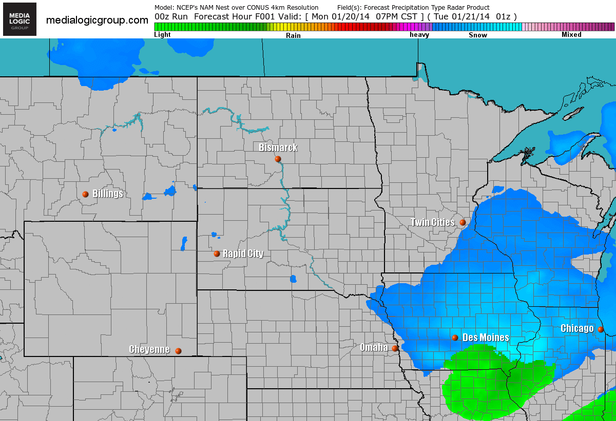
Light Snow Through AM Wednesday
Here's the light snow potential from PM Tuesday - midday Wednesday
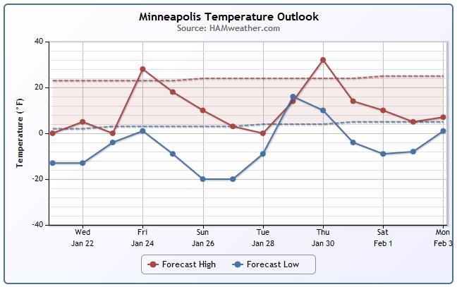
Temperature Trend
At first, the temperature trend doesn't look all that bad, but when you realize what the scale is, we could be in for a long next several days. Some of the extended forecasts suggest a fairly cold end to January.
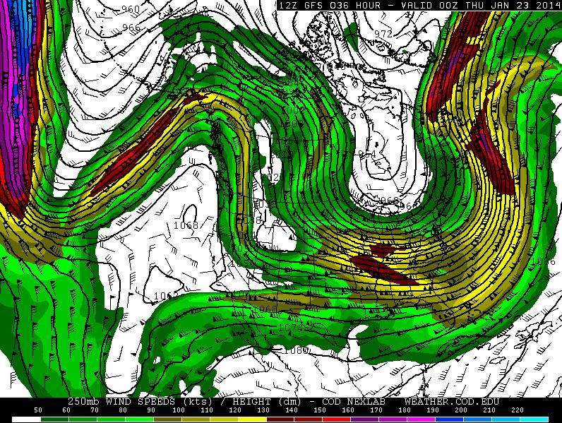
High Amplitude
Breaking news... it's winter! I suppose we have to put up with bouts of cold, but it certainly seems like we've had plenty so far this season doesn't it? Looking ahead through the end of January, indications support a colder than average trend for the eastern U.S.. Note how the ribbon of color (jet stream) looks so wavy. The jet stream typically bubbles and buckles and cold air tries to migrate south and warm air tries to lift north. What's interesting about this pattern is that we've haven't seen much deviation in this type of setup for quite some time. The bubble or ridge across the western U.S. has been nearly persistent over the past 13 months!
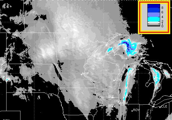
Cold Air Sink South
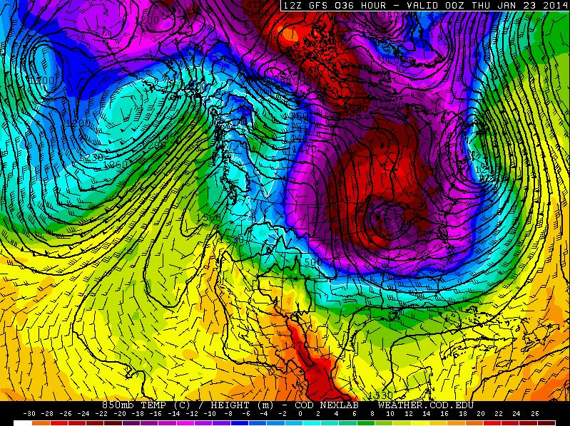
Look at how much colder it was across the Great Lakes Region on Tuesday. It's that dreaded Polar Vortex you heard too much about at the beginning of January. A lobe of that Arctic air has once again been displaced by that weather term we've come to love to hate.
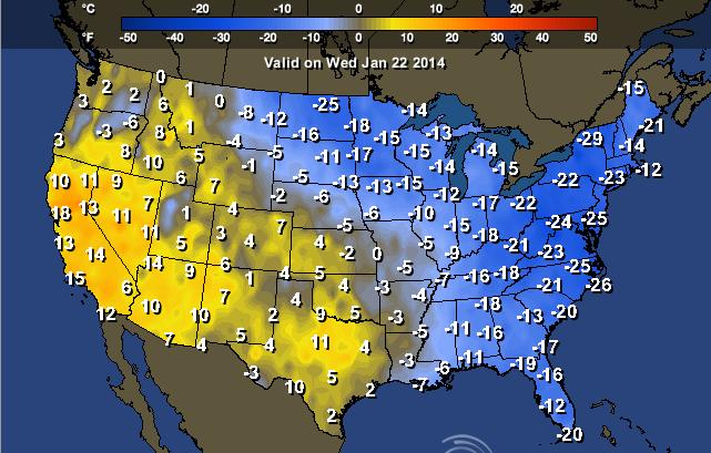
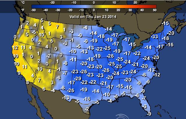
Continued Cold
Here are the temperatures through the rest of the week. The nasty cold appears to continue taking up residence across the eastern half the U.S. and especially across the Northeastern quadrant of the nation.
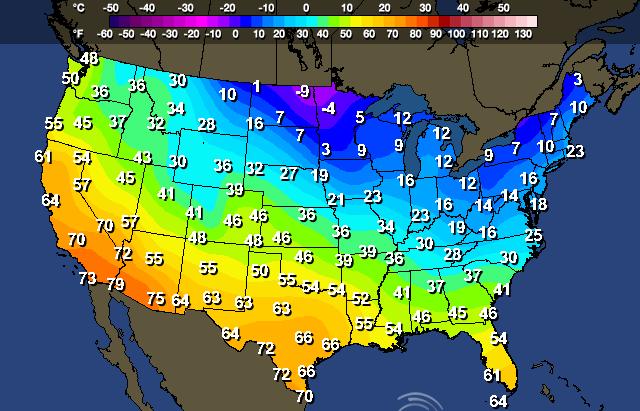
Highs Wednesday
Here are the high temperatures for Wednesday. Note all the single digit highs across the northern tier of the nation. There are even a few locations that will struggle to get above 0F for daytime highs Wednesday across the Red River Valley.
Highs From Normal Wednesday
Once again, the eastern part of the U.S. finds itself well below average.
Thursday looks even colder as another clipper dives south. Note that the only spot above average are locations west of the Rocky Mountains!
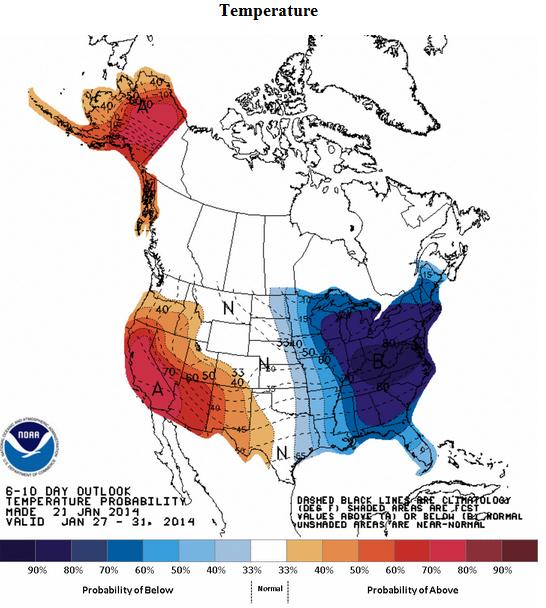
Temperature Outlook
According to NOAA, the 6 to 10 day temperature outlook looks remain well below average in the eastern U.S. while the western U.S. should stay above average.
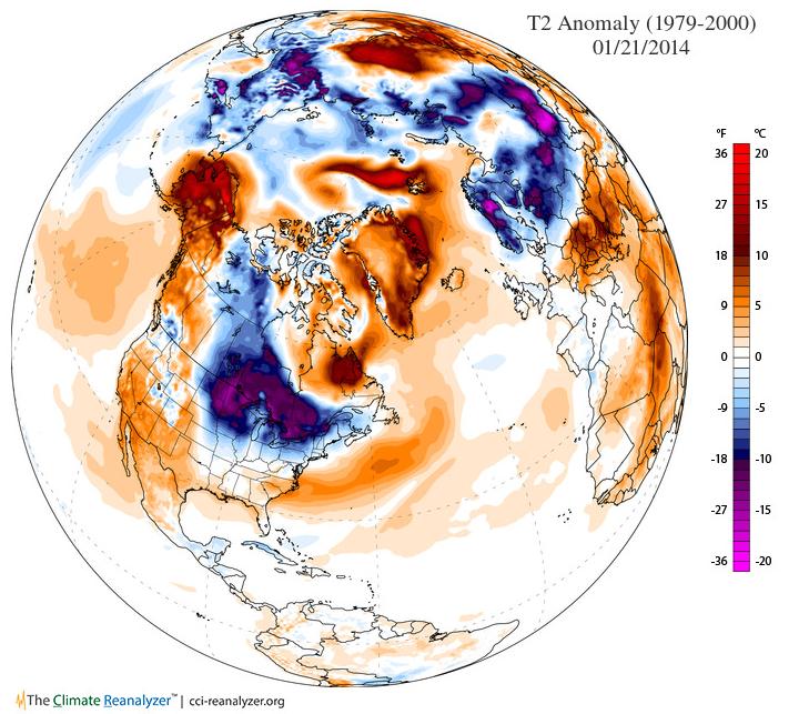
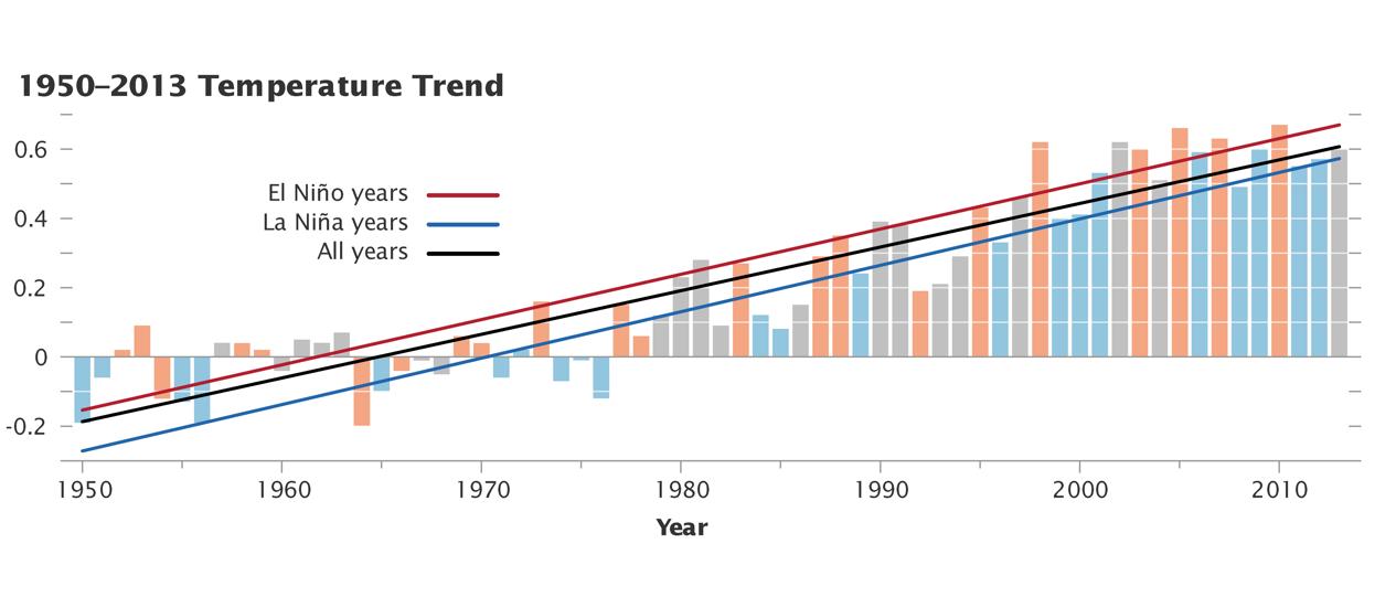
Global Temp Trend
This is interesting... while we've been freezing in the eastern U.S. it's hard to imagine that much of the globe has been warmer than average. In fact, 2013 will go down as 7th warmest year on record across the globe since 1880.
"An analysis of global temperatures by NASA scientists shows that 2013 was the seventh warmest year since 1880 (tied with 2006 and 2009). Nine of the 10 warmest years on record all have occurred since 2000, with 2010 and 2005 ranking as the warmest. This graph shows how the long-term temperature trend has continued to rise even when El Niño and La Niña events skew temperatures warmer or colder in any one year. Orange bars represent global temperature anomalies in El Niño years, with the red line showing the longer trend. (The classification of years comes from the NOAA Oceanic Niño Index.) Blue bars depict La Niña years, with a blue line showing the trend. El Niño/La Niña neutral years are shown in gray, and the black line shows the overall temperature trend since 1950. Note that even the La Niña years are warmer than they used to be."
Read more from NASA HERE:
Here's another link:
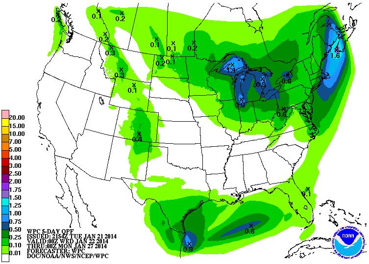
Precipitation Outlook
According to NOAA's 5 day precipitation outlook, there doesn't seem to bee a terrible amount of moisture anywhere in the U.S. of any substantial nature. Continued clippers will help to bring minimal amounts of precip to the eastern part of the U.S., but we stay dry for much of the western U.S.
Thanks for checking in and have a great rest of your week.
Don't forget to follow me on Twitter @TNelsonWNTV

No comments:
Post a Comment