By Todd Nelson
The morning low on Tuesday will be the 42 sub-zero low of the winter season, which will fall short of getting into the "Top 10 Winter for Lows with Days Below Zero" for now by 3. Just glancing at weather forecasts over the next several days, we get close to dipping below zero, but should stay just above it for the rest of the week.
With the slight bump in the temperature department, the storm track finds it's way back into our neck of the woods. Our first clipper in the clipper parade arrives later today with a quick coating of snow. The next fast moving system drops into the region by Thursday and yet another one could blow through the area on Saturday! Each one will bring the chance of a light coating of snow, which appears to be no more than just a nuisance at this point.
The big story heading into next week is going to be the ensuing warmup! It doesn't appear to be record warmth heading our way, but noticeable enough that we may actually have a chance to thaw out for consecutive days.
I'm encouraged by what appears to be a change in the weather pattern for the 2nd half of Feb., but I guess that means we'll be using more of the blue bug juice for the windshield.
___________________________________________________________________________
MONDAY NIGHT: Mostly clear, cold and quiet. Low: -14F. Feels Like: -25F.
TUESDAY: Raw start. Increasing clouds with light snow later. High: 12. Feels Like -20F early. Winds: S 10-25.
TUESDAY NIGHT: Coating of snow overnight. 1" to 2" possible across northern Minnesota. Low: 7 and warming.
WEDNESDAY: Lingering AM flurries. Clearing a bit with another clipper arrives in the afternoon. Snow possible in northern MN. High: 22.
THURSDAY: Mild start with a few light snow showers. Breezy afternoon. Wake-up: 12. High: 30.
FRIDAY: Clearing and a bit cooler. Wake-up: 6. High: 16.
SATURDAY: Yes, another clipper. Light snow chance. Wake-up: 6. High: 26.
SUNDAY: Bright sun, brisk wind. Wake-up: 12. High: 27.
MONDAY: Much needed thaw arrives. Wake-up: 14. High: 33.
____________________________________________________________________________
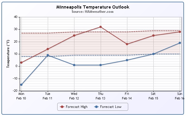
Minneapolis Temperature Trend
According to weather model data, we're going to FINALLY head in the right direction or at least be a little closer to average later this week/weekend. Tuesday mornings low will be brutal again, but note the gradual warming into Thursday. After spending so mays days in the Arctic cellar, 30F is going to feel amazing!
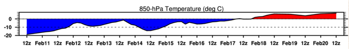
850mb Temperature Trend
Here's another look at the temperature trend for the Minneapolis into next week. The 850mb level is located a few thousand feet off the ground. At this level, temperature trends can be tracked a little easier, but it implies how surfaces temperatures may respond as this level warms or cools. The important thing to note is that we see red by next week! That means that temperatures at this level may actually warm above the freezing warm, which would help surface temperatures warmup as well!
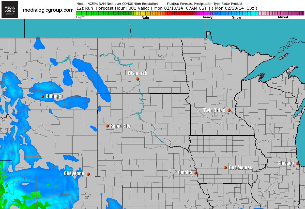
Tuesday Clipper
Here's a view of the first of many clipper expected to roll through the Upper Mississippi Valley over the next several days. This particular clipper will move in later Tuesday with a quick coating of snow by AM Wednesday.
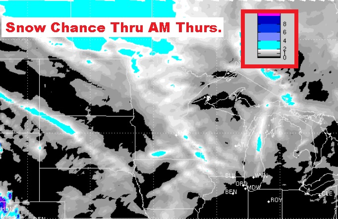
Snow Chance
Here's a view of snowfall potential through AM Thursday, which will also encompass another clipper PM Wednesday/AM Thursday. It doesn't look like much, but there could be some light accumulations across parts of Minnesota through that time frame.
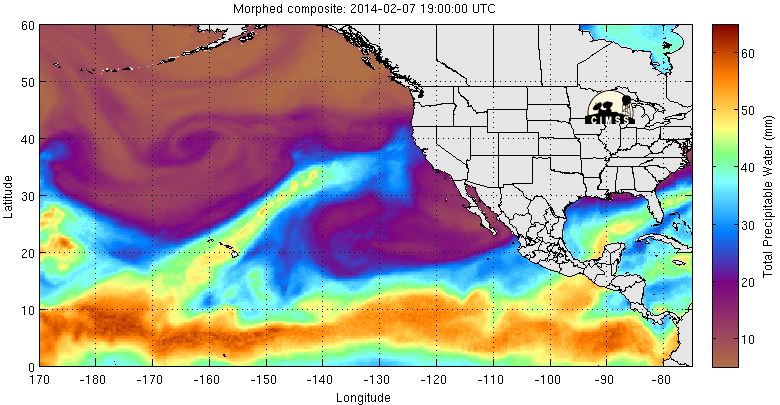
Atmospheric River Continues
The western part of the country has seen quite a bit of moisture since last week all thanks to a deep plume of tropical moisture originating from near Hawaii. Note the finger of bright colors stretching from the Hawaiian Islands to the West Coast.
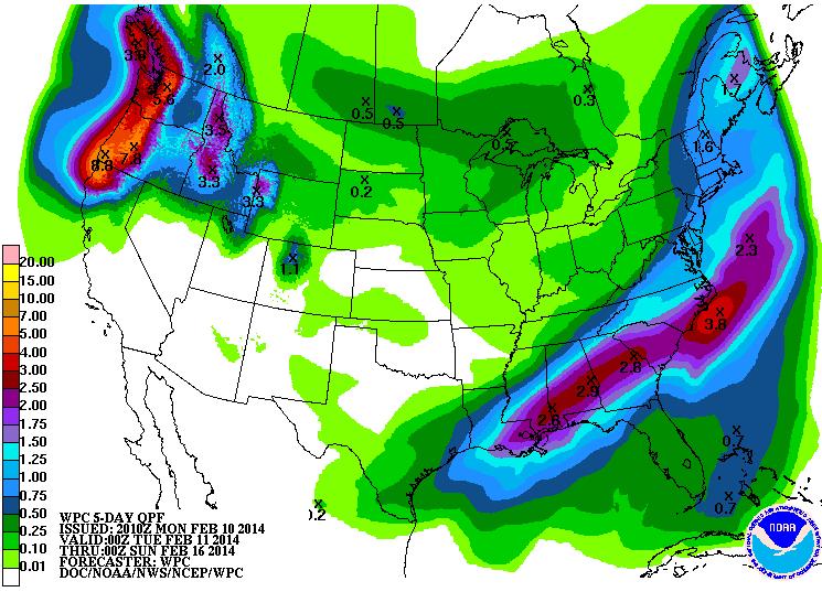
More Western Precipitation on the Way
According to NOAA's HPC, the 5 day precipitation forecast still suggests a bunch of moisture through the end of the week!
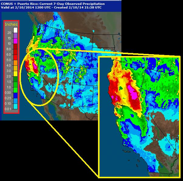
Precipitation Past 7 Days
This is unreal... In just a matter of days, we've seen nearly 12" of total liquid precipitation across parts of northern California.
Update on Folsom Lake
Folsom Lake was in the news recently about how low the water level was. How about this, after a weekend of heavy rainfall, Folsom Lake has risen nearly 15ft! WOW!
"Folsom Lake has risen about 15 feet in just four days of rain, and continues to increase as showers linger into Monday morning. That’s according to preliminary data recorded by sensors on the lake. The increase may be hard to see with the naked eye, but puddles around the lake on the western edge, and streams near Browns Ravine have taken over what has been a dry, barren landscape."
See more from Fox40.com HERE:
(Image courtesy: Fox40.com)

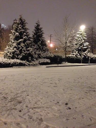
Record Seattle Snow
Thanks to my good friend Nicholas Shipes for this picture out of Seattle, WA where 2.9" of snow fell on Saturday! That was good enough for a daily snowfall record. The old record was only 0.4" set in 1957.
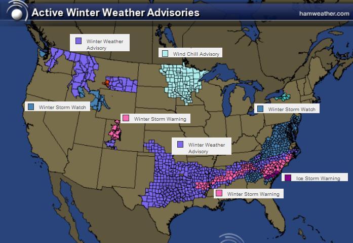
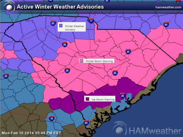
More Wintry Weather on the Way
Take a look at all the winter weather headlines that have been issued by the national weather service across the nation. Note that a few remain in the western U.S., but there are certainly not as many as there used to be. Note also the large swath of wintry weather headlines from the Lower Mississippi Valley to the Mid Atlantic Region. There will be a fairly significant swath of snow and ice potential through AM Thursday.
Here's the latest from the National Weather Service:
"...A major winter storm will affect the Lower Mississippi Valley and southeastern U.S. through mid-week...
...More heavy rain/snow expected across the Pacific Northwest...
The second week of February will be quite active with another round of wintry precipitation forecast across the southern tier of the country this week. A frontal boundary sinking southward into the northern Gulf of Mexico will allow northerly flow to persist along the Gulf Coast. This will ultimately draw cool Canadian air from the dome of high pressure to the north which should bring readings to near the freezing mark. With the sub-freezing air in place, a series of mid-level impulses will cross overhead resulting in precipitation which should spread from west to east across the Deep South. What will complicate matters is a tongue of warmer air just above the surface layer should lead to a mixture of freezing rain and sleet. This region of mixed wintry precipitation will focus along the rain/snow line with fairly extensive ice accumulations being forecast by the WPC winter weather desk. Through Wednesday evening, the current forecast depicts anywhere from 2 to 6 inches of snow from northern Mississippi eastward into much of North Carolina. A localized heavier axis is possible along upslope regions of the Southern Appalachians. Additionally, bounding this area of snow to the south will be sufficiently high ice accumulations extending from northern Louisiana through central portions of the southern states into the southeastern U.S. coast. The current maxima is expected from eastern Georgia into central South Carolina with 0.50 to 0.75 inches of ice possible. Of course any measurable ice will make travel hazardous."
Empty Store Shelves in Georgia
How about this... I guess people are taking this store seriously. The store shelves are nearly empty in Smyrna, GA. Thanks to Steve Schmidt for the picture!
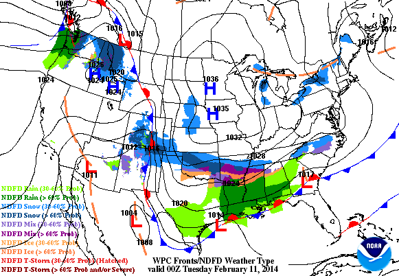
FutureRadar Through PM Wednesday
Here's the outlook through PM Wednesday, which shows a fairly robust blob of moisture across the Gulf Coast States through that time period. This southern branch of precipitation is going to fall in a wintry fashion. Unfortunately, there's a pretty good snow and freezing rain potential.
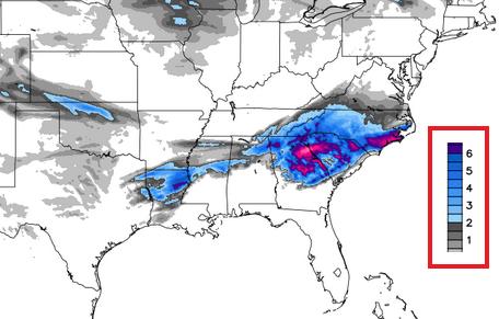
Southern Snow Potential
Snowfall amounts could ramp up quickly with this particular system as it nears the Carolinas. The particular image below suggests 3" to 6"+ possible in some areas from Georgia to North Carolina by Wednesday evening.
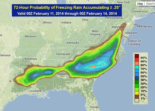
Icing Potential
Here's NOAA's probability of 0.25" or more through Thursday. Note the near 80% chance across parts of the Carolinas.
Ice Storm Warning
The National Weather Service out of Charleston, SC has issued an Ice Storm Warning for parts of South Carolina from PM Tuesday into AM Thursday.
...ICE STORM WARNING IN EFFECT FROM MIDNIGHT TUESDAY NIGHT TO 10 AM EST THURSDAY... THE NATIONAL WEATHER SERVICE IN CHARLESTON HAS ISSUED AN ICE STORM WARNING...WHICH IS IN EFFECT FROM MIDNIGHT TUESDAY NIGHT TO 10 AM EST THURSDAY.
* ICE ACCUMULATIONS...AROUND ONE QUARTER OF AN INCH.
* TIMING...RAIN IS FORECAST TO MIX OR CHANGE TO FREEZING RAIN TUESDAY EVENING INTO THE OVERNIGHT HOURS...THEN CONTINUE INTO AS LATE AS THURSDAY MORNING.
* IMPACTS...SIGNIFICANT ICE ACCUMULATIONS COULD CREATE DANGEROUS OR IMPOSSIBLE DRIVING CONDITIONS...ESPECIALLY ON BRIDGES...OVERPASSES AND UNTREATED ROADS. DAMAGE TO TREES AND POWER LINES ARE LIKELY AS WELL AS POWER OUTAGES ACROSS THE AREA.
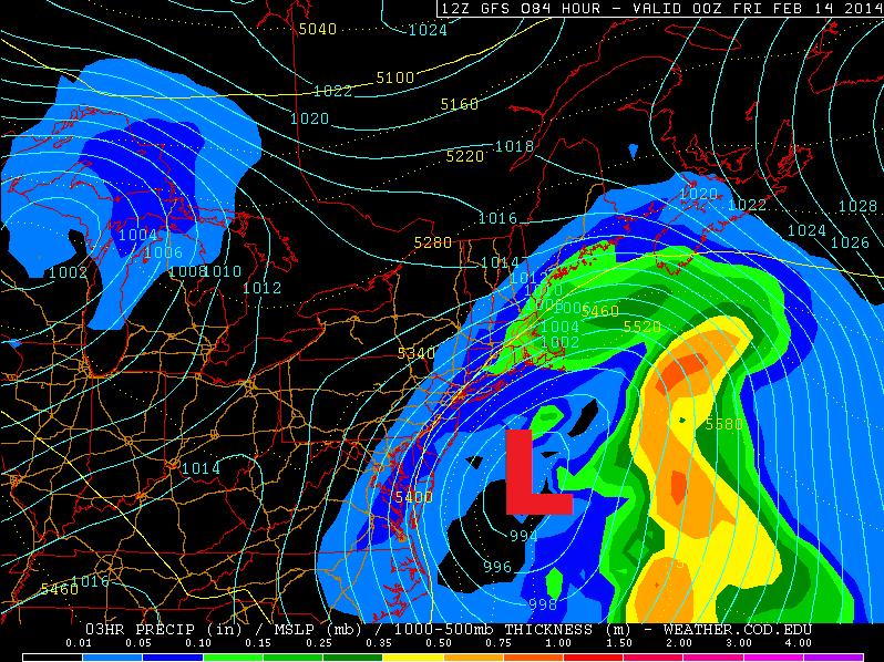
Watching the Low Track Northeast
This is going to be an interesting storm system to watch develop. Not only will it have significant impacts on places in the south, but there may also be some issues later this week in the Northeast as the storm intensifies... The storm track could bring accumulating snow to the coastal communities in the Northeast as it skirts along the coast. Stay tuned!
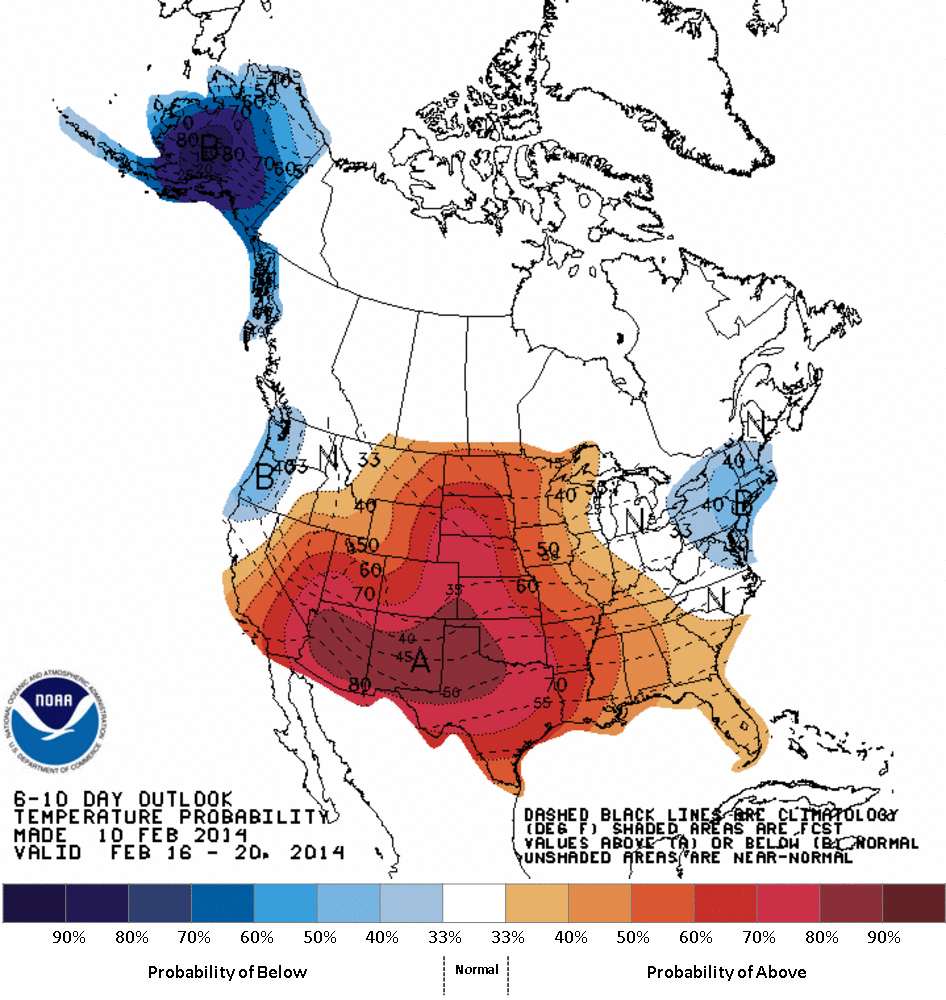
Warmer Weather Ahead
Here's a graphic that a few folks might be appreciative of... NOAA's Climate Prediction Center suggests that the 6 to 10 day temperature outlook looks much warmer than what we've currently been dealing with! Note also how Alaska will be cooling down during this time frame.
Thanks for checking in and have a great rest of your week!
Don't forget to follow me on Twitter @TNelsonWNTV

No comments:
Post a Comment