By Todd Nelson
I know, I know... you're probably looking at the forecast for Monday and wondering when this brutally cold weather is going to break. No doubt the winter thus far has been tough. The average temperature of both December and January ran more than -7F below average and February is off to an Arctic start too with readings nearly -14F below average.
We don't get much of a reprieve through early this week. In fact, the peak of our current cold wave will be with us through Tuesday before any noticeable change moves in. By Wednesday, the mercury finally tops out in the 20s and it looks like we may be turning a corner at that point. Some of the extended weather models suggest warmer weather heading into the second part of February. According to NOAA's Climate Prediction Center, the 8 to 14 day temperature outlook suggests warmer temperatures by much of next week.
As the slightly warmer weather moves in, snow chances will return too. The clipper parade will begin Tuesday night with our first shot of light snow. It could be a fairly steady parade with as many as 4 clippers by next weekend.
Funny, for as much snow as there is on the ground, we're only about 3" above normal this season.
____________________________________________________________________
SUNDAY NIGHT: Mostly clear and very cold. Low: -13. Feels Like: -25F. Wind: WNW 5-10.
MONDAY: Lung burning cold continues. High: 2. Feels Like: -30F early. Wind: WNW 5.
MONDAY NIGHT: Mostly clear, cold and quiet. Low: -13F. Feels Like: -25F.
TUESDAY: Raw start. Increasing clouds with light PM snow. High: 12.
WEDNESDAY: Lingering AM flurries. Another clipper arrives late with snow possible in northern MN late. Wake-up: 11. High: 25.
THURSDAY: Clearing and a bit colder. Wake-up: 16. High: 19.
FRIDAY: Partly sunny, still brisk. Wake-up: 3. High: 15.
SATURDAY: Not as bone chilling. Few flakes. Wake-up: 6. High: 20.
SUNDAY: Warmer. Peeks of sun.Wake-up: 14. High: 26.
______________________________________________________________________
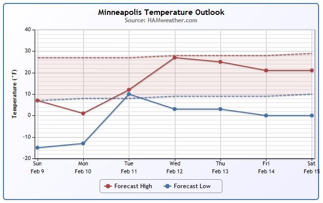
Minneapolis Temperature Trend
Unfortunately, we start the week off with some brutally cold temperatures, but rebound nicely heading into the middle part of the week. Keep in mind that the majority of the week with be rather cold, especially at night., but it appears that longer range weather models are suggesting more of a modest warmup by the second half of February!
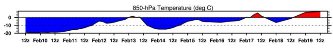
850mb Temp Trend
Here's a different look at a temperature trend map. The 850mb level is a few thousand feet off the ground, but it shows a fairly good representation of how surface temperatures may respond as temperatures aloft warmup or cooldown. The Minneapolis temperature trend map shows a fairly significant pool of cold air over us at the start of the week and again by the end of the week, but a more modest warmup may be in the offing by next week. In fact, the extended forecast suggests temperatures above the freezing mark (red) a few thousand feet off the ground over Minneapolis by next week!
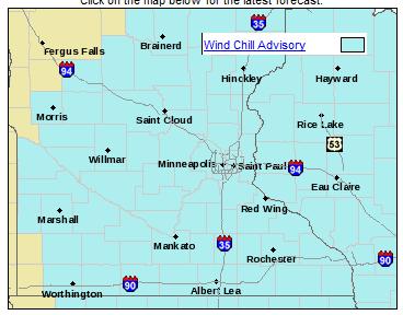
Wind Chill Advisory
Here's the latest from the National Weather Service...
...WIND CHILL ADVISORY REMAINS IN EFFECT FROM 9 PM THIS EVENING TO 11 AM CST MONDAY...
A WIND CHILL ADVISORY REMAINS IN EFFECT FROM 9 PM THIS EVENING TO 11 AM CST MONDAY.
* WIND CHILL VALUES...BETWEEN 25 BELOW AND 35 BELOW TONIGHT INTO MONDAY MORNING.
* IMPACTS...FROSTBITE OR HYPOTHERMIA CAN RESULT FROM THE LOW WIND CHILLS IF PRECAUTIONS ARE NOT TAKEN.
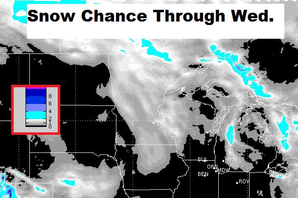
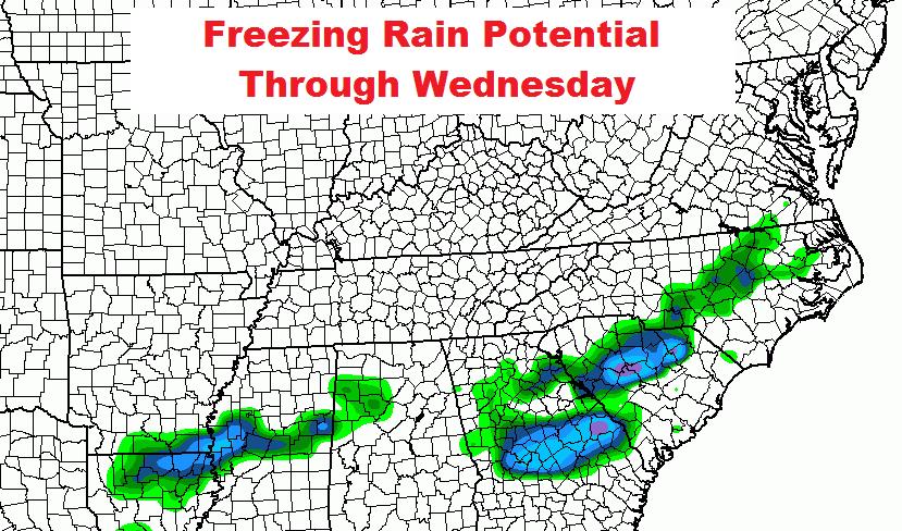
Snow Chance Through Wednesday
Here's a glance at snow chances through midday Wednesday. This will encompass our first clipper system by Tuesday night... Stay tuned for more.
Snowy in the Central U.S.
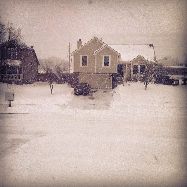
Thanks to my good friend Matt Dux for the picture below near Kansas City, MO where it snowed AGAIN over the weekend. Earlier last week, he picked up nearly 10" for a different storm.
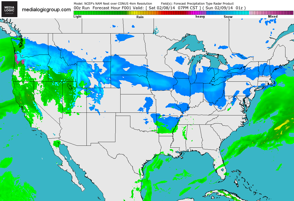
Another Winter Storm For the Deep South
Take a look at the FutureRadar into the early week and note the fairly robust moisture moving across the central and eastern part of the country. Note also how far south this wintry precip is getting. The National Weather Service has issued a number of winter weather headlines into early this week for the potential of heavy snow and icing.
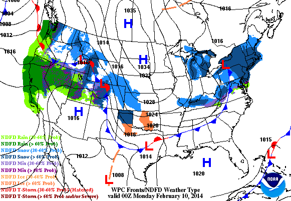
FutureRadar with Fronts
Here's a product from NOAA, which shows the precipitation potential along with the weather features. Note the developing low across the southeastern corner of the U.S. that will be responsible for all the wintry weather through the early part of the week.
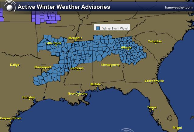
Winter Heads South AGAIN!
The active weather continues this February with yet again another winter storm for the Gulf Coast States. It wasn't that long ago that we were talking about major issues in Birmingham, AL and Atlanta, GA. Let's hope we don't have a repeat from a couple of weeks ago!
Here's a sample of the winter weather concerns from the National Weather Service out of Peachtree City, Ga:
...WINTER STORM WATCH REMAINS IN EFFECT FROM MONDAY EVENING THROUGH WEDNESDAY MORNING... * LOCATIONS...PORTIONS OF NORTH GEORGIA...MAINLY ALONG AND NORTH OF A LINE FROM CARROLLTON TO ATLANTA TO HOMER. * HAZARD TYPES...A MIX OF RAIN...SLEET AND SNOW MONDAY NIGHT... CHANGING BACK TO RAIN TUESDAY AFTERNOON...THEN A MIX OF FREEZING RAIN AND SLEET TUESDAY NIGHT WITH SNOW IN THE MOUNTAINS. * ACCUMULATIONS...THERE IS THE POTENTIAL FOR 1 TO 3 INCHES OF SNOWFALL ACROSS THE NORTHERN ATLANTA SUBURBS AND NORTHWEST GEORGIA. FOR THE NORTHEAST GEORGIA MOUNTAINS...THERE IS THE POTENTIAL FOR THREE TO SIX INCHES OF SNOW WITH LOCALLY HIGHER AMOUNTS.
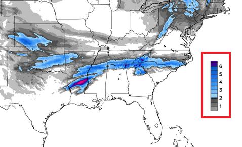
Southern Snow Potential
Here's a quick glance at snowfall potential, which suggests a narrow band of accumulating snow from the Central Plains to the Carolinas by Tuesday night.
(image credit: WeatherBell.com)
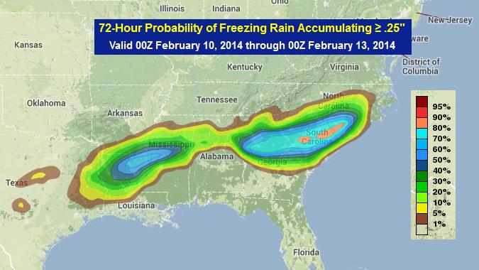
Southern Ice Potential
Unfortunately, we're also looking at an freezing rain threat again. Here's a glance at where some of the freezing rain could be positioned into the early week time frame.
Freezing Rain Probability
Here's a NOAA product that shows the probability of 0.25" or more of freezing rain through midweek. The brighter blues indicate a 50% chance, while the pink color over parts of South Carolina suggests a near 80% chance!
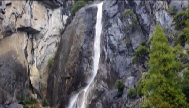
Water Falling in Yosemite
Keep it coming! Thanks to some much needed precipitation, the landscape looks a little different at Yosemite National Park lately. Here's the view from the Yosemite National Park Facebook Page:
"Rain is currently falling in Yosemite, giving new life to the waterfalls. Here's what Lower Yosemite Fall looked (and sounded) like earlier today. -cf"
See the video HERE:
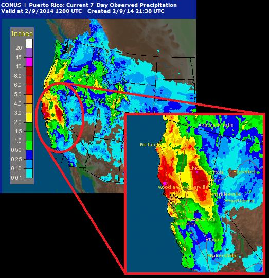
Western Precip Past 7 Days
According to radar estimates of precipitation over the past 7 days. Some spots across northern California have seen nearly 5" to 10"+ since last week!
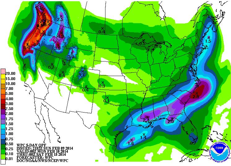
More Western Precipitation
According to NOAA's HPC, the 5 day precipitation forecast still suggests a fairly decent amount of precipitation for the western part of the country.
Thanks for checking in and have a great week ahead!
Don't forget to follow me on Twitter @TNelsonWNTV

No comments:
Post a Comment