By Todd Nelson
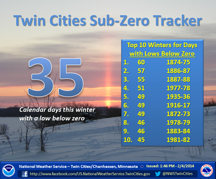
According to data collected by the National Weather Service out of the Twin Cities, we've just come off of our 17th coldest December-January in 142 years of data! Here's another cold weather stat you can take to the water cooler today; we are currently sprinting towards the record number of sub-zero nights of 60 set in 1874-75! As of February 4th, we have seen 35 sub-zero nights and according to recent model runs, we could add on to that number for much of the next 5 to 7 days.
I guess there is one benefit of the colder than average weather; the storm track as been displaced to our south keeping those nasty winter storms south of us. Since Saturday, there have been 3 plowable snow events, which have disrupted travel significantly from Texas to Chicago to New York and places in between. If you can believe it, another large winter storm may be brewing by late weekend for folks in the Northeast.
Not sure when old man winter will officially loosen his grip on us across the country, but hey - meteorological spring is only 3.5 weeks away! By the way our average high today is 26F, March 1st it's 34F and March it's 48F! Hang in there -Todd Nelson
__________________________________________________________________________
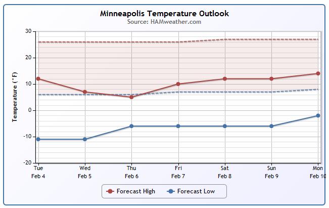
TUESDAY NIGHT: Mostly quiet and cold. Snow stays well south, over Iowa. Low: -3. Feels Like: -20F.
WEDNESDAY: Partly sunny, feels like -20F in the AM. High: 5. Winds: NW 10.
WEDNESDAY NIGHT: Another frigid night, bitter wind chills return. Low: -13. Feels Like: -25F.
THURSDAY: Harsh AM wind chills, more Arctic sunshine. High: 3
FRIDAY: Stuck in a cold rut. Wake-up: -8. High: 10
SATURDAY: More clouds, slight chance of light snow. Wake-up: -3. High: 12
SUNDAY: East Coast storm. Blue sky here. Wake-up: -2. High: 8
MONDAY: Mostly dry, mostly cold. Wake-up: -6. High: 7
TUESDAY: Is it spring yet? Wake-up: -6. High: 11.
_______________________________________________________________________________
Minneapolis Temperature Trend
According to extended model runs, we still have some pretty chilly weather into the second week of February.
Twin Cities Cold Continues
It certainly has been a cold winter thus far. In fact, according to the National Weather Service, the Twin Cities had their 17th coldest December-January period in 142years of data! We've also seen 35 sub-zero nights (through February 4th) and it appears that they'll keep coming over the next 5 to 7 days.
"The number of sub-zero lows in the Twin Cities this winter continues to pile up. As of this morning, we are now up to 10 straight days with a low below zero. The 35 sub-zero lows this winter is the most since 37 were recorded in the winter of 1995-96."
See more from the NWS MPX HERE:
February 5th is National Weatherperson's Day!
Did you know that February 5th is National Weatherperson's day? I'm forecasting a 5% chance of breakfast in bed and a 40% chance of a stray tomato by the afternoon... Remember, I don't make the weather, I'm just a messenger. Yes, this cold and snowy winter is wearing on all of us!
It is a day that is actually in recognition of John Jeffries birthday! Who is he?
See more from the National Weather Service out of St. Louis, MO HERE:
"February 5 is National Weatherperson's Day, commemorating the birth of John Jeffries in 1744. Jeffries, one of America's first weather observers, began taking daily weather observations in Boston in 1774 and he took the first balloon observation in 1784. This is a day to recognize the men and women who collectively provide Americans with the best weather, water, and climate forecasts and warning services of any nation."

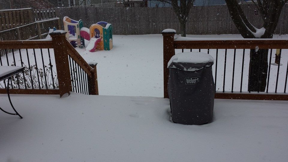
Snowy Tuesday in Kansas City, MO
Thanks to my good friend Matt Dux out of Kansas City, MO for this picture. At the time of the picture, he said there was around 3" to 4" of snow on the ground.
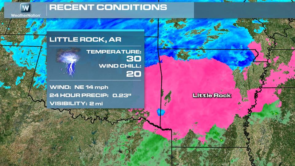
TS FZRAPL??
Take a look at this weather report from the Little Rock, AR airport on Tuesday morning... Not sure I've ever seen this type of report before! The weather observer at the Little Rock airport just prior to 9am Tuesday reported a thunderstorm with freezing rain and ice pellets! Now that's some wild weather! Here's the official METAR report:
KLIT 041447Z 05012KT 2SM TS FZRAPL BR OVC008CB M01/M03 A3009 RMK AO2 TSB37FZDZE07FZRAB07PLB37 OCNL LTGIC OHD TS OHD MOV NE P0013
(image below was from just before 9am Tuesday)
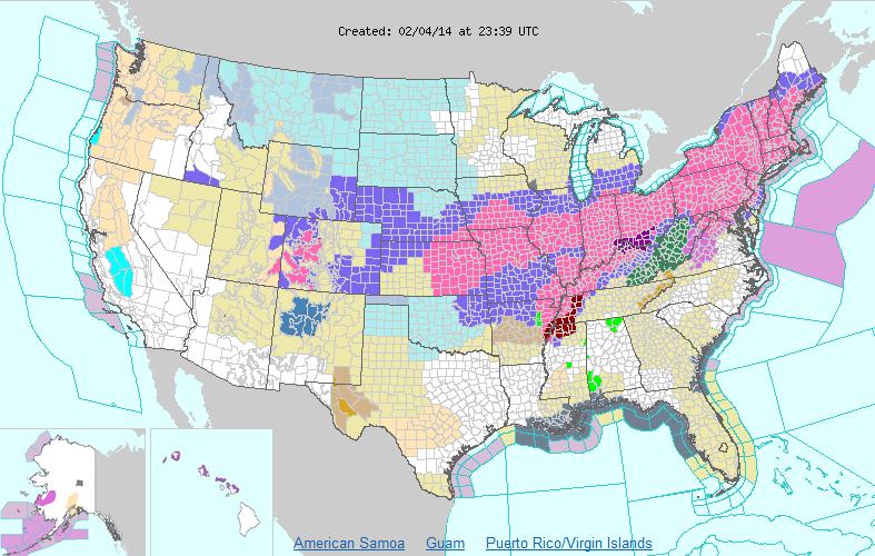
Major Winter Storm Slides East
Although is wasn't 50% of the national landmass covered in winter weather headlines, more than 50% of the states in the Lower 48 were under some sort of winter weather headline on Tuesday from the current storm system. Heavy snow and ice were and will be impacting places from the central U.S. to the Northern New England states through Wednesday.
FutureCast
Take a look at the futurecast from PM Tuesday - PM Thursday as this storm winds up over the Central Plains and exits the Northeast. Also note the additional moisture moving into the western part of the country by the end of the loop, this could be the makings of our weekend storm system... stay tuned!

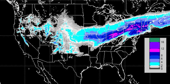
Snowfall Forecast
This was the snowfall forecast from midday Tuesday through Midday Thursday. Note how this particular storm is expected to bring another significant swath of snow all the way to the Eastern Seaboard.
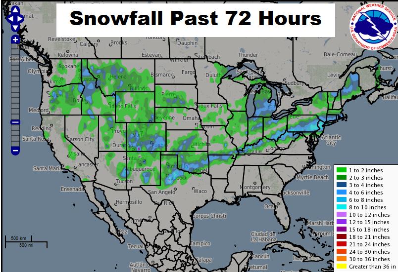
Snowy Stripes
OK - this is getting a little outrageous... We're currently on our 3rd major winter storm since last weekend and there's potentially another one headed for parts of the Northeast by the weekend! I don't know about you, but I'm getting a little exhausted. Take a look at the 72 hour snowfall analysis from the National Weather Service, note the snowy stripes that are oriented from southwest to northeast. It's a winter storm shooting gallery!
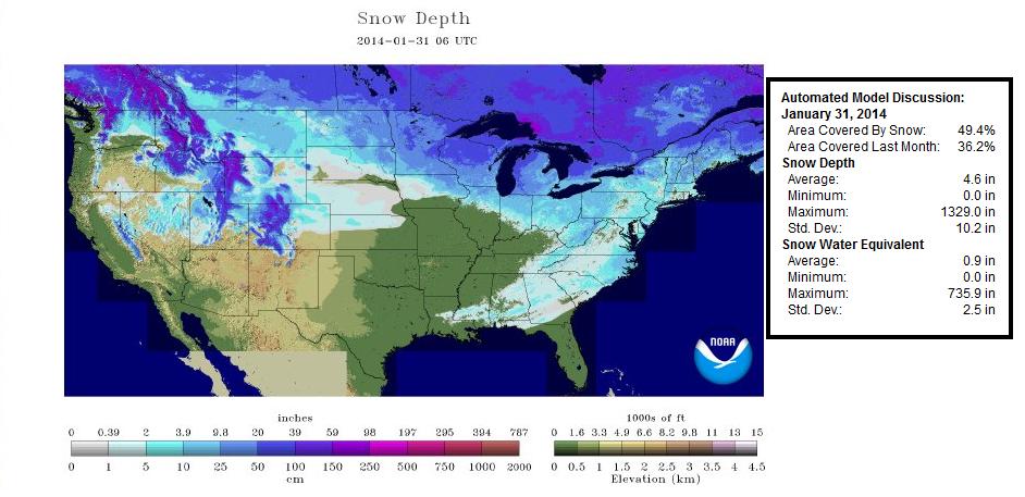
Jump in Snow Depth
With 3 storm systems since last weekend, we've seen a more than 10% jump in U.S. snow coverage. Take a look at the U.S. snow depth across the nation from Friday, January 31st to Tuesday, February 4th:
Friday, January 31st
Here you can see the lingering snow/ice across parts of the southeast from late last week.
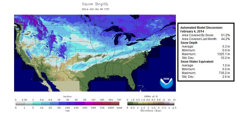
Tuesday, February 4th
In this view, not only have we seen a dramatic loss in snow/ice across across parts of the southeast, but we've seen a dramatic increase across parts of the Central/Southern Plains. There are also spots in the Northeast that have filled in.
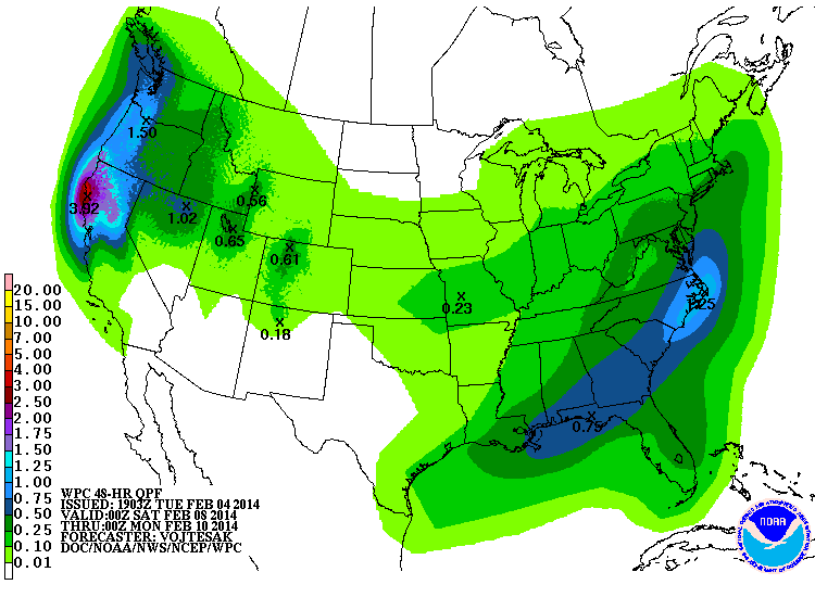
Another Weekend Storm?
Here's the precipitation forecast from NOAA's HPC. The forecast from PM Friday into PM Sunday suggests additional moisture moving into the Northeast once again. Temperatures will likely be cold enough for additional wintry precipitation. There's still some uncertainty with this particular event, so stay tuned for later forecasts.
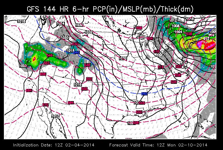
GFS American Model
The GFS is still suggesting some heavier snow potential by the late weekend/early Monday time frame in parts of the Northeast.
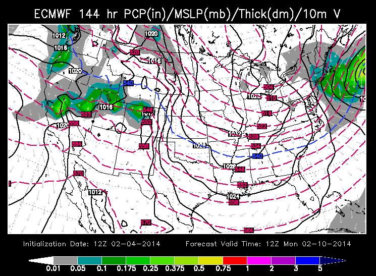
ECMWF
Interestingly, the European model (ECWMF) is showing a little less intense storm (if any at all) during that same time frame. At this point, it's still a bit too early to call this one way or another. More importantly, it appears that this active pattern looks to continue, so we'll continue to monitor the weather maps for any further developments!
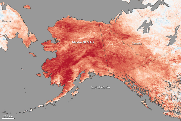
Record Alaskan Warmth
Thanks to NASA's Earth Observatory for this information and image.
"A persistent ridge of high pressure off the Pacific Coast fueled the warm spell, shunting warm air and rainstorms to Alaska instead of California, where they normally end up. The last half of January was one of the warmest winter periods in Alaska’s history, with temperatures as much as 40°F (22°C) above normal on some days in the central and western portions of the state, according to Weather Underground’s Christopher Bart. The all-time warmest January temperature ever observed in Alaska was tied on January 27 when the temperature peaked at 62°F (16.7°C) at Port Alsworth. Numerous other locations—including Nome, Denali Park Headquarters, Palmer, Homer, Alyseka, Seward, Talkeetna, and Kotzebue—all set January records."
See more from EarthObservatory.nasa.gov HERE:
Thanks for checking in and have a great rest of your week!
Twitter: @TNelsonWNTV

No comments:
Post a Comment