-1 F. low in the Twin Cities Monday.
16 F. high yesterday.
26 F. average high for February 3.
13 F. high on February 3, 2013.
14" snow on the ground.
1984: "Surprise Blizzard" across Minnesota and parts of the Dakotas. Meteorologists were caught off guard with its rapid movement. Persons described it as a "wall of white." Thousands of motorists were stranded in subzero weather. Only a few inches of snow fell, but was whipped by winds up to 80 mph. 16 people die in stranded cars and outside. Source: Twin Cities National Weather Service.
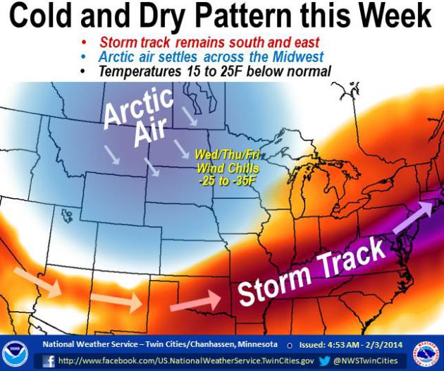
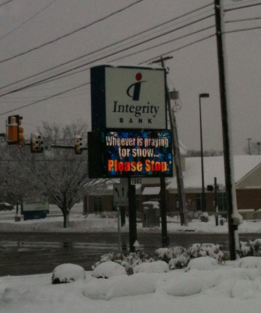
A Real Winter
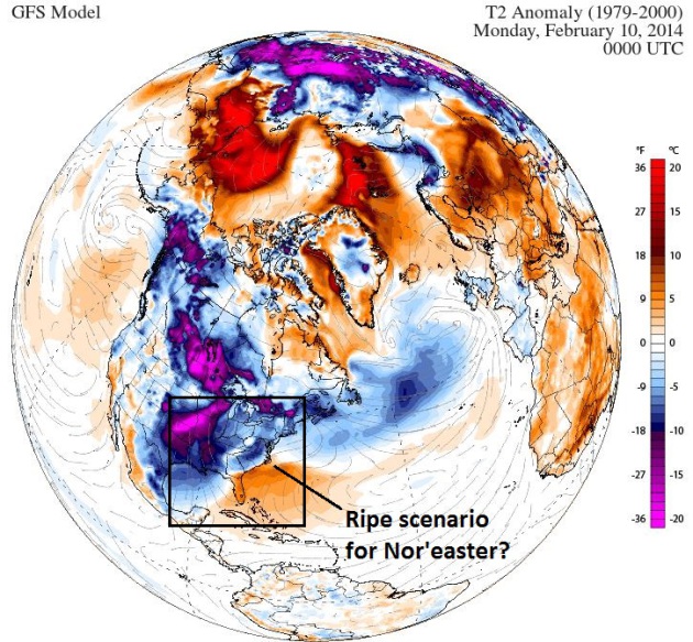
15 inches of snow on the ground. No grumpy e-mails from snow lovers this winter, for a change. So far MSP has picked up nearly 40 inches of powder; 5 inches more than average, to date - and almost 17 inches more than last winter as of February 4. And just about all of it came from a cold conga-line of clippers. Each new reinforcing blast of Canadian chill was preceded by a few inches of fluff.
It adds up, especially when steering winds direct from the Arctic Circle prevent any extended thaws.
If anyone asks (doubtful) we just topped 5,000 heating degree days since July 1, 2013. That means we've spent about 7.5 percent more heating our homes & businesses than during an average winter. Whatever "average" is.
While a parade of shovel-worthy storms pass south - Minnesota enjoys cold and quiet weather into next week; 5 more subzero lows between Thursday & Monday, followed by a thaw the middle of next week.
At some point a higher sun angle will start to make a dent in this stubborn, nagging whirlpool of cold air, what's left of the much-maligned Polar Vortex.Right now I see an extended spell of 30s, even a few 40s the 3rd week of February.
Yes, I'm ready for the Spring Vortex.
2014: A Tale Of Meteorological Haves And Have-Nots.
The drought continues to deepen in California, while snowfall amounts
are trending well above average for many cities in the central and
eastern USA. Today's Climate Matters looks at the extremes setting up, speculating on what the big weather story in 2014 may be: "WeatherNationTV
Chief Meteorologist Paul Douglas looks at the "conga line of storms"
that keep moving across the United States, one right after another. A
number of these systems have brought much above average snowfall to
Philadelphia and parts of the Northeast and Mid-Atlantic states. While
the East is wetter than average, the West finally saw rain after a
record setting 52 days without a drop in Sacramento. Will there be a
break in the pattern? Or will the drought end up being the biggest
weather story of 2014?"
Time Is Running Out For California Drought Relief.
Considering the wet season on the west coast spills over into early
March we still have a few weeks to make up for what some are calling the
worst drought since 1977, possibly longer. Here's an excerpt of a Climate Central post from meteorologist Andrew Freedman: "The
California drought, now reaching into its 13th month, grows more
devastating with each passing day and there is no sign of significant
relief in sight. More than halfway through the state's wet season and
the Sierra Nevada snowcap
all but non-existent, California's prospects for making up its
precipitation deficit are slim. The snowcap will yield precious little
water and the state would need to get an average of about a foot or more
of rain in the next two months to make up the difference. Forecasts are
not offering much hope of that..."
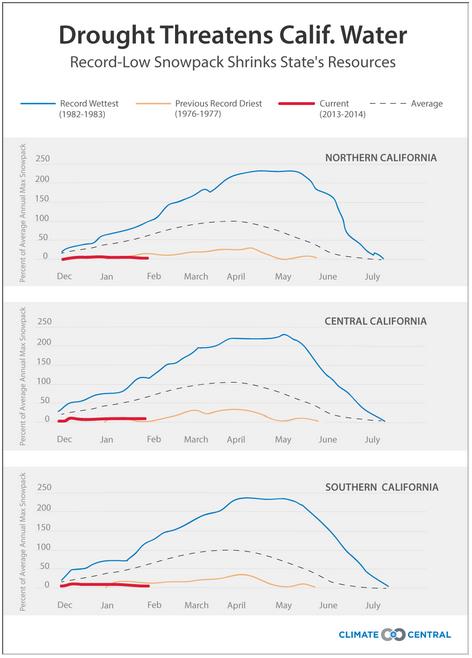
Graphic credit above: "Comparison
of the water content in California's mountain snowpack so far this
year, compared to the state's wettest and driest years." (The data is divided by region.) Climate Central using CDWR data.
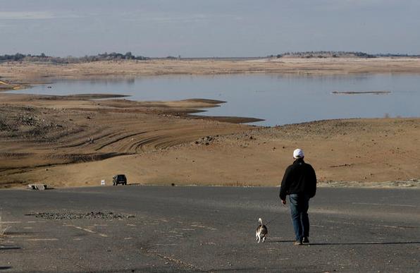
Photo credit above: "The 2014 water year, which began Oct. 1, is on track to be even drier than the devastating drought of 1976-77." (Rich Pedroncelli / Associated Press / January 31, 2014).
California Farmers Brace For Drought, Unemployment.
We've quickly gone from inconvenience to crisis mode with California's
drought - at this rate 2014 is going to be long, potentially historic
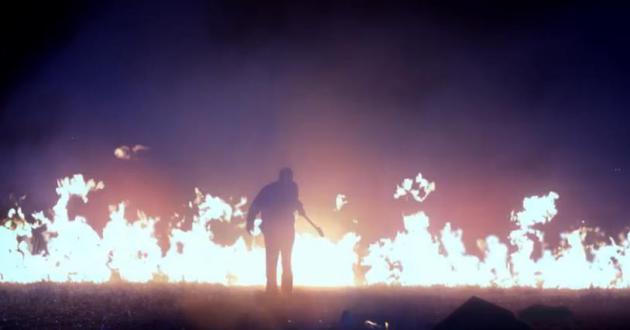
year, and I don't even want to think about the wildfire season to come.
Here's a clip from AP and ABC News: "Amid
California's driest year on record, the nation's leading agricultural
region is locked in drought and bracing for unemployment to soar,
sending farm workers to food lines in a place famous for its abundance.
One-third of the Central Valley's jobs are related to farming. Strains
on water supplies are expected to force farmers to leave fields
unplanted, creating a ripple effect on food processing plant workers,
truck drivers and those who sell fertilizer, irrigation equipment and
tractors..."
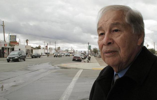
Photo credit above: "In
this Thursday Jan. 30, 2014 photo, Mendota, Calif. Mayor Robert Silva,
72, explains how the state’s drought is sure to drive up unemployment in
his rural farming town during an interview in Mendota. Five years ago,
the last dry year and height of the national recession, farm workers
lined up for free food as unemployment exceeding 40 percent in Mendota.
Silva fears that this year the food lines will be even longer." (AP Photo/Scott Smith).

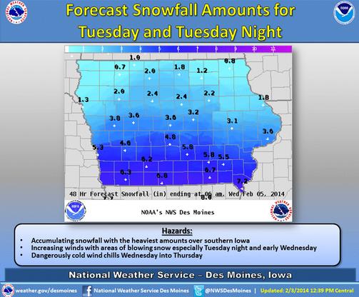
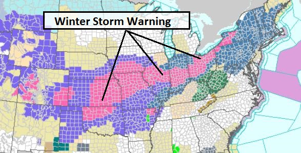
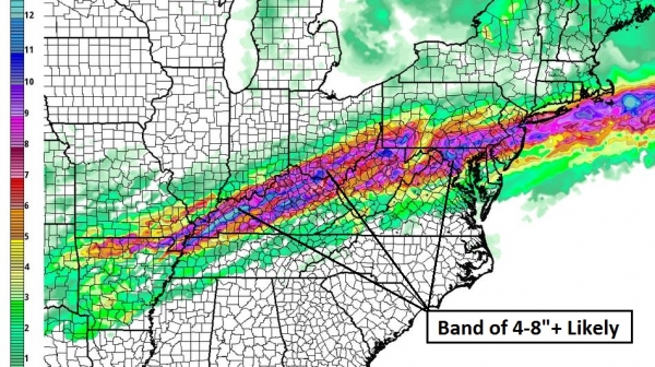
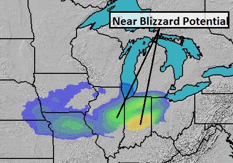
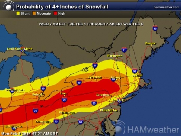
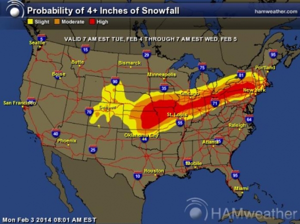
* America's Snow Machine revs into high gear again this week with 2 distinct storms, one already impacting the Mid Atlantic, Northeast and coastal New England; a second storm pushes across the Central Plains into the Midwest and Ohio Valley Tuesday into Wednesday.
* Second surge of snow spreads across Plains into Midwest today into Wednesday; Chicago forecast to pick up 2-4" with heaviest snow bands probably passing south of Windy City; greater potential for 6"+ amounts Kansas City to Peoria to Indianapolis, Toledo, Detroit and Cleveland.
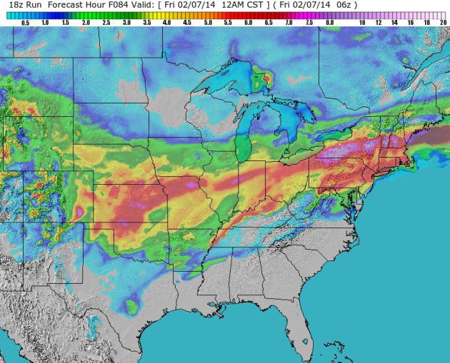
Long-range guidance shows a significant thaw east of the Rockies next week. The next 36-48 hours will bring the most delays/cancellations and overall weather headaches. Although I won't be referring to spring fever anytime soon, conditions do improve, nationwide, by next week.
Paul Douglas - Senior Meteorologist - Alerts Broadcaster


Image credit above: REUTERS/China Daily.


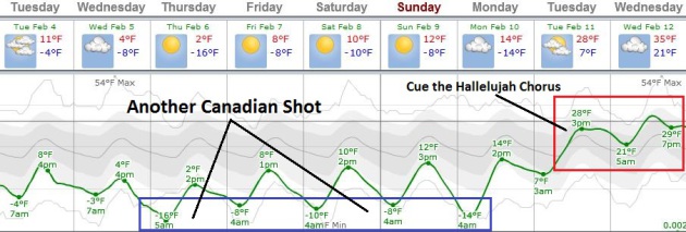
TODAY: Clouds increase. Dry sky. Winds: N 10. High: 17
TUESDAY NIGHT: Mostly cloudy; snow stays well south, over Iowa. Low: -4
WEDNESDAY: Partly sunny, feels like -20F. High: 5
THURSDAY: Plenty of sun. Cold, but quiet. Wake-up: -14. High: 4
FRIDAY: Intervals of sun. What February? Wake-up: -9. High: 11
SATURDAY: More clouds than sun. Brisk. Wake-up: -7. High: 10
SUNDAY: East Coast storm. Blue sky here. Wake-up: -9. High: 13
MONDAY: Fading sun, warm-up begins. Wake-up: -3. High: 19
* 30s are likely by the middle of next week. Whoop Whoop!
Climate Stories....
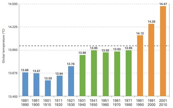
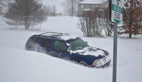
Photo credit above: "The harsh winter we are having shouldn’t be viewed as a refutation of global warming, but rather as further evidence of a growing problem. Pictured: Trying to get around in Cortland, Ill. on Jan. 4, 2014." (Michael Kappel, courtesy Flickr).

- Southwestern North America and other subtropical regions are going to become increasingly arid as a consequence of rising greenhouse gases.
- The transition to a drier climate should already be underway and will become well established in the coming years to decades, akin to permanent drought conditions.
- This is a robust result in climate model projections that has its source in well represented changes in the atmospheric hydrological cycle related to both rising humidity in a warmer atmosphere and poleward shifts of atmospheric circulation features.
Floating
ice (light blue) and grounded ice (dark blue) in lakes of Alaska’s
North Slope near Barrow, as seen by ESA’s ERS-2 satellite in 2011.
Credit: Planetary Visions / University of Waterloo, Canada / ESA
Read more at http://www.redorbit.com/news/science/1113061766/winter-ice-is-on-the-decline-across-alaskan-lakes/#mUUJ2lR8DRBE3TAs.99
Read more at http://www.redorbit.com/news/science/1113061766/winter-ice-is-on-the-decline-across-alaskan-lakes/#mUUJ2lR8DRBE3TAs.99
According to a new study from the European Space Agency,
ice in northern Alaska’s lakes during winter months is on the decline.
Twenty years of satellite radar images in the study, which was published
in The Cryosphere, show how shifts in our climate are affecting high-latitude regions.
[ Watch the video: Monitoring Lake Ice ]
Alterations in air temperature and winter precipitation over the last 50 years have affected the timing, interval and density of the ice cover on lakes in the Arctic, the study said.
Read more at http://www.redorbit.com/news/science/1113061766/winter-ice-is-on-the-decline-across-alaskan-lakes/#mUUJ2lR8DRBE3TAs.99
No comments:
Post a Comment