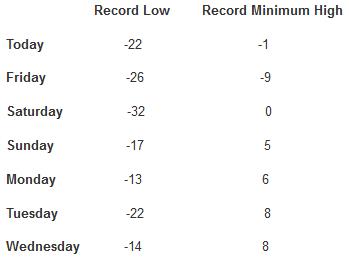
TODAY: Inch or 2 of snow. Greasy roads. Winds: S 10. High: 15
FRIDAY NIGHT: Windy, turning colder. Low: -3
SATURDAY: Colder, another inch of fluff. Icy roads. High: 4
SUNDAY: Sun returns. Won't help much. Wake-up: -13. High: 1 (wind chill: -20)
MONDAY: Blue sky, less wind. Wake-up: -10. High: 8
TUESDAY: Few flurries, not quite as cold. Wake-up: 2. High: 16
WEDNESDAY: Mostly cloudy. Almost tolerable. Wake-up: 11. High: 25
THURSDAY: Some recovery. Not as numb. Wake-up: 13. High: 28
The Winter Games
The
Winter Olympics are over - all the pomp, drama, hype & melting
Sochi slush now history. But we're all reluctant medalists in the Real
Winter Olympics. Events have included full frontal aerobic shivering,
synchronized shoveling, and the breathtaking & horrific spectacle of
freeway-traffic ice-dancing.
Bronze goes to Detroit, enjoying the
coldest winter
since the Truman Administration. Silver goes to Minnesota; much of the
state proud to be colder than any time in 35 years. It’s a photo-finish,
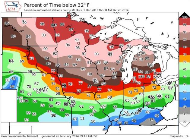
but Grand Forks gets Gold; since December 1 a full 99% of the time has
been colder than 32F.
I’d get off the podium but my knees are frozen in place.
At
some point I hope we’ll have a solid scientific explanation for why the
jet stream became locked in a polar flow for 3 months. I suspect rapid
warming of the Arctic since 2010 somehow disrupted the polar jet, but I
can’t prove it scientifically, not yet. Just a hunch.
The next jab
of unreasonably cold air sparks an inch or two today; no controversial
storms brewing anytime soon. 2 more subzero lows early next week, then a
run of 20s. The models insist we'll be basking in 30s by mid-March.
I'm ready for the Winter Games to be over.
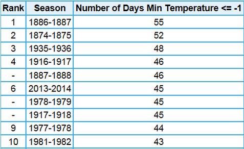
4th Most Subzero Nights On Record at MSP.
As of Thursday the Twin Cities have experienced 46 nights below zero,
tying for 4th since 1873. At the rate we're going, with at least 2-3
more nights of subzero fun, I suspect we'll wind up 3rd on the all-time
list, potentially more subzero nights than 1935-36. Source:
Twin Cities National Weather Service.
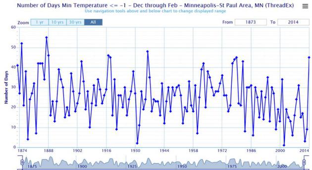
Bucking The Trend.
We've seen fewer subzero nights, on average, since about 1980s, a
gradual decline in the number of pioneer winters. But this winter is
proving to be the exception. Source: Twin Cities National Weather
Service.
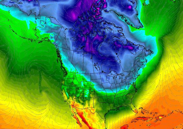
Son Of Polar Vortex.
Glancing at the maps you'd never believe meteorological spring is hours
away. Historically (ha!) the coldest 90 days of the year end right
around March 1. As far as the atmosphere is concerned, winter really
goes from about December 1 to March 1. Will we have another tortured
spring with snow into early May? I doubt it, but with the jet stream
perpetually stuck all bets are off. North American temperatures above
courtesy of Climate Reanalyzer.
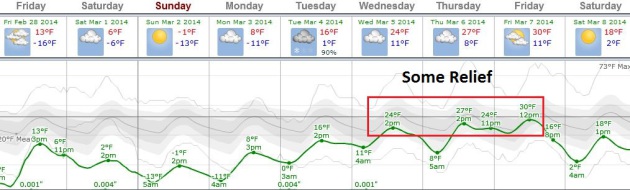
Another Subzero Smack - Then Some Improvement.
Clippers today, again Saturday mark the leading edge of yet another
Canadian Treat; subzerl lows likely Sunday and Monday morning before
some recovery takes place the latter half of next week, with highs in
the 20s to near 30 by Thursday and Friday. ECMWF data trends:
Weatherspark.
Record Territory.
Back in 1963 the Twin Cities endured 23 days worth of hours below zero.
We just passed 20 days worth of negative numbers (over 480 hours below
zero), according to
Daryl Herzmann at the Iowa Environmental Mesonet. Good grief. Make it stop.
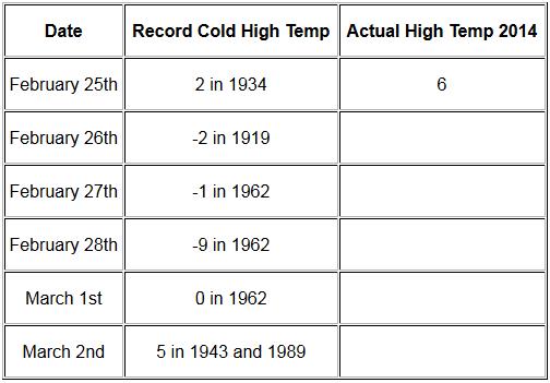
Coldest Daytime Highs - More Records Imminent? The short answer appears to be yes. Here's a post from the
Twin Cities National Weather Service:
"The current cold snap, which is a part of the coldest winter in 35
years, is breaking records again. The coldest high temperatures that
have been recorded back to the late 1800s on February 25 through March 2
are listed for the Twin Cities, St. Cloud and Eau Claire.
Percentage Of Time Below Freezing Since December 1.
I was feeling pretty blue about the Twin Cities being colder than 32F
for over 90% of the time since December 1, the start of Meteorological
Winter. And then I saw Grand Forks coming in at 99%. Thanks to
Iowa Environmental Mesonet for cheering us up.
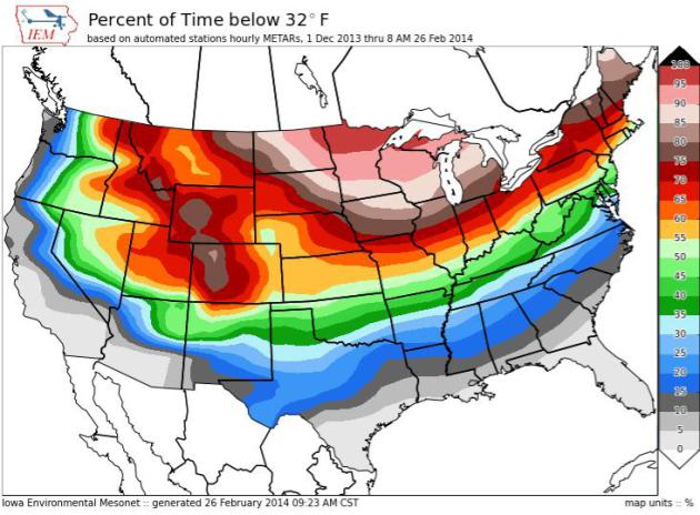
National Percentage of Time Below 32F Since December 1. Not much of a break from the Upper Mississippi Valley and Great Lakes into much of New England.
Details here.
All-Time Records Next 7 Days (average high at MSP on February 27 is 33F, average low is 18F)
* Thanks to Aaron Shaffer at WeatherNation TV for tracking these down from the
Minnesota Climatology Working Group. I can't believe I'm still showing this stuff...
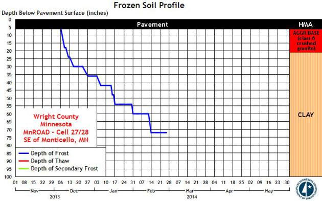
Deep Ground Frost.
I've had a few questions about the depth of the frost this
super-winter, concerns about wells freezing up, and how deep frost in
the ground might escalate run-off and flooding when it does finally
decide to warm up. According to MnDOT the depth of the frost near
Monticello is between 70-75", which is deeper than I can ever recall.

No comments:
Post a Comment