By Todd Nelson
How many sub-zero nights does it take to get before you book a tropical vacation?
You won't feel as guilty hitting the submit button on your travel plans after I tell you that we have now tied the top 10 spot for winters with days with lows below zero! Go ahead and book that cruise or flight south now. Take your sandals and the golf clubs with, you won't be needing them around here anytime soon.
It takes some mental toughness to accept what some long range model runs continue to spit out. Although long range temperatures trends tend not to be super accurate, it's hare to argue with the fact that our current weather pattern doesn't look to change until maybe the second week of March.
Another Arctic front arrives later today with strong, biting winds through the afternoon and evening. There could be a few light snow showers as the front blasts through, but it won't be newsworthy. The big story today will be the window rattling winds that make us rethink our decision to live as far north as we do.
Bitter cold temperatures stick around through next week, but we'll introduce several chances of light snow by the weekend.
End of weather rant...
________________________________________________
TUESDAY NIGHT: Mostly clear and cold. Low: -14. Winds: NW 10-15. Wind Chill: -30F.
WEDNESDAY: Frigid start. Arctic front arrives. Harsh PM winds with a few PM flakes. High: 17. Winds: Turning WNW 15-30mph. Wind Chill: -30F
WEDNESDAY NIGHT: Breezy and very cold. Low: -14. Winds: NW 15-30. Wind Chill: -30F
THURSDAY: Bitter cold. Think spring! High: -3
FRIDAY: Cold. Clouds thicken with light snow late across southern MN. Wake-up: -13. High: 5
SATURDAY: Meteorological Spring Begins! Light snow chances in southern MN. Wake-up: -9. High: 3.
SUNDAY: Still cold, more light snow chances. Wake-up: -6. High: 9.
MONDAY: Peeks of cold sunshine. Wake-up: -1. High: 12.
TUESDAY: No break in the Arctic temps. Wake-up: -2. High: 9.
_________________________________________________
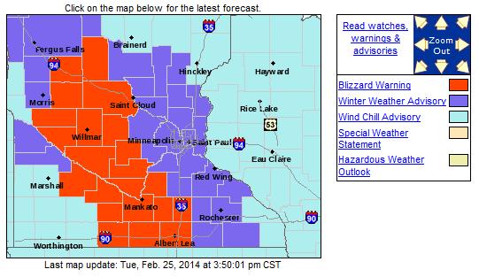
WINTER WEATHER HEADLINES
...STRONG WINDS WILL LEAD TO BLIZZARD CONDITIONS WEDNESDAY AFTERNOON AND WEDNESDAY NIGHT...
...DIFFICULT OR IMPOSSIBLE TRAVEL CONDITIONS EXPECTED DUE TO DRIFTING SNOW OVER ROADWAYS...
.A BLIZZARD WARNING HAS BEEN ISSUED FOR MUCH OF WESTERN AND SOUTHERN MINNESOTA FOR WEDNESDAY AFTERNOON AND WEDNESDAY NIGHT. A WINTER WEATHER ADVISORY HAS ALSO BEEN ISSUED FOR WEDNESDAY AFTERNOON AND WEDNESDAY NIGHT FOR EAST CENTRAL MINNESOTA AND STEVENS...LAC QUI PARLE...AND YELLOW MEDICINE COUNTIES.
VERY STRONG WINDS ARE EXPECTED TO DEVELOP WEDNESDAY AFTERNOON AND CONTINUE INTO MUCH OF WEDNESDAY NIGHT AND COLDER AIR PUSHES IN. WIND GUSTS COULD REACH 50 MPH IN PLACES. DUE TO VERY DEEP SNOWPACK...WIDESPREAD BLOWING SNOW IS EXPECTED WHICH COULD LEAD TO DRIFTS ON ROADWAYS EXCEEDING 3 FEET IN OPEN LOCATIONS. THIS WILL MAKE TRAVEL VERY DIFFICULT OR IMPOSSIBLE BY WEDNESDAY EVENING.
A WIND CHILL ADVISORY REMAINS IN EFFECT FOR ALL OF CENTRAL AND SOUTHERN MINNESOTA INTO WEST CENTRAL WISCONSIN LATER TONIGHT THROUGH WEDNESDAY MORNING AS WIND CHILLS WILL DROP TO BETWEEN 25 BELOW ZERO AND 35 BELOW ZERO.
FOR THE BLIZZARD WARNING...
* TIMING...MID TO LATE WEDNESDAY AFTERNOON THROUGH LATE WEDNESDAY NIGHT.
* VISIBILITY...1/4 MILE OR LESS. WHITEOUT CONDITIONS ARE EXPECTED AT TIMES.
* WINDS...NORTHWEST WINDS 25 TO 35 MPH WITH GUSTS AS HIGH AS 50 MPH.
* IMPACTS...WIDESPREAD BLOWING SNOW AND LARGE DRIFTS OVER ROADWAYS. DUE TO THE DEEP SNOW PACK...SOME DRIFTS MAY EXCEED 3 FEET IN OPEN AREAS. THIS COULD MAKE TRAVEL NEARLY IMPOSSIBLE.
FOR THE WINTER WEATHER ADVISORY...
* TIMING...MID TO LATE WEDNESDAY AFTERNOON THROUGH LATE WEDNESDAY NIGHT. * VISIBILITY...1 MILE OR LESS.
* WINDS...NORTHWEST WINDS 20 TO 30 MPH WITH GUSTS OF 40 TO 50 MPH.
* IMPACTS...AREAS OF BLOWING SNOW AND DRIFTING OVER ROADWAYS.
FOR THE WIND CHILL ADVISORY...
* WIND CHILL VALUES...25 TO 35 BELOW ZERO LATE TONIGHT THROUGH WEDNESDAY MORNING.
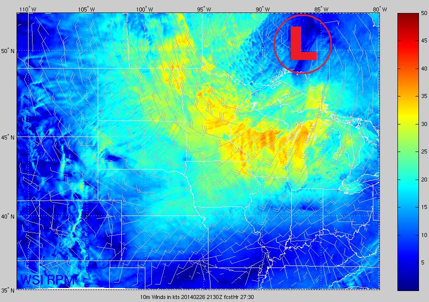
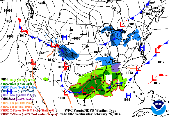
Strong Winds Wednesday
Take a look at the strong wind field across the Upper Mississippi Valley for Wednesday. This tightly wound storm system will quickly drop through the Great Lakes Region and kick up a robust wind field. Here's the strong wind field by Wednesday afternoon, which shows winds gusting to +30mph across a large area. This will be the source of the widespread blowing snow across the region, which may cause ground blizzard conditions across parts of southwestern Minnesota.
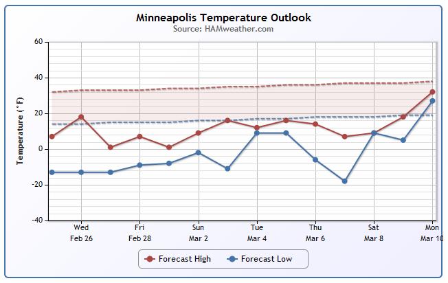
Minneapolis Temperature Trend
Yup... Still cold! Check back later for warming.
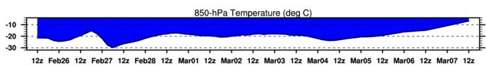
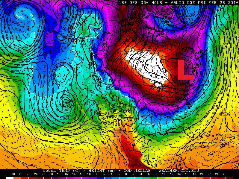
850mb Temp Trend
It doesn't get much better here either. The 850mb temperature trend shows readings well below the freezing mark through early March... UGH!
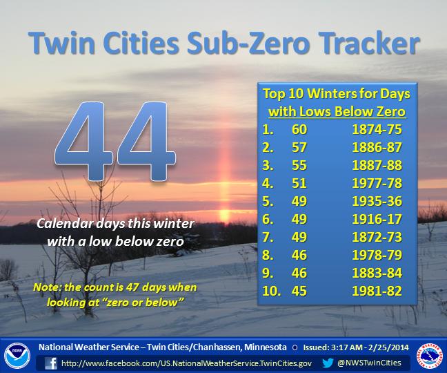
Sub-Zero Nights
As of Tuesday, there have been 44 days with sub-zero lows in the Twin Cities. This number will continue to rise over the next 5 to 7 days. It is possible that we could be in the top 5 by early next week!
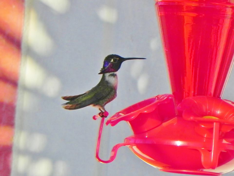
Arizona Hummingbird
Thanks to Rich Koivisto for the image below. Looks like the resident hummingbird is enjoying a quick rest and a sweet treat!
Soggy Outlook Ahead
Take a look at the weather outlook through PM Thursday and note the significant push of moisture across the West Coast. This first big push of moisture will be the first of two through the end of the week.
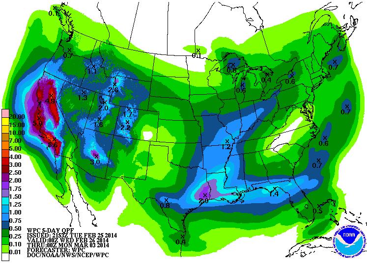
Precipitation Potential
According to NOAA HPC, the 5 day precipitation forecast looks exceptionally juicy over California through the end of the weekend. In some cases, precipitation amounts could near 3" to 6" or more! Unfortunately, the ground is like concrete from being so dry for so long. There is a substantial flooding risk as runoff could be a major concern.
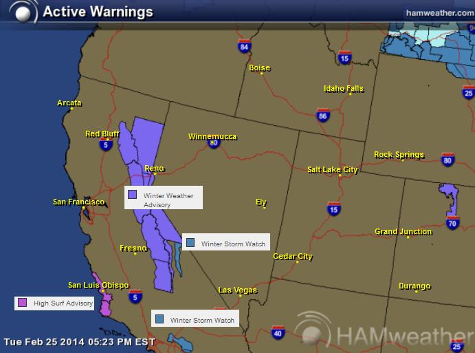
Western Warns
The National Weather Service has issued a number of Winter Weather Headlines from the Sierra Nevada Mountains to the San Bernadino Mountains. Significant accumulations of snow may be possible by the time these two storm systems blow through.
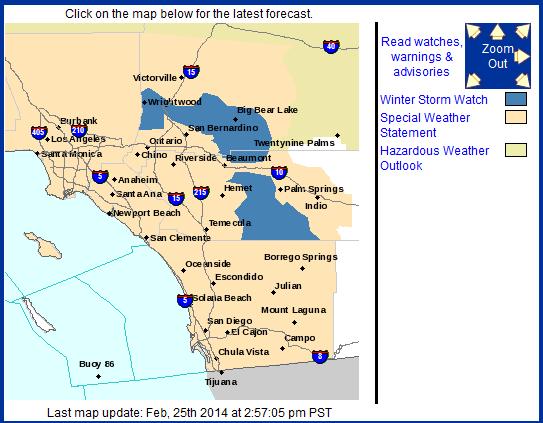
Southern California Snow Chances
...WINTER STORM WATCH REMAINS IN EFFECT FROM FRIDAY MORNING THROUGH FRIDAY EVENING...
* ELEVATION... ABOVE 6000 FEET. * SNOW LEVELS...ABOVE 7000 FEET THURSDAY NIGHT...LOWERING TO AROUND 6000 FEET FOR FRIDAY AFTERNOON AND EVENING...THEN DOWN TO BETWEEN 5000 AND 5500 FEET BY SATURDAY NIGHT. * SNOW ACCUMULATIONS...6 TO 10 INCHES POSSIBLE ABOVE 6000 FEET WITH LOCAL AMOUNTS OF 2 TO 4 FEET ON HIGHER PEAKS...MAINLY ABOVE 7000 FEET. * TIMING...PRECIPITATION DEVELOPS LATE THURSDAY NIGHT. SNOW LEVELS WILL LOWER DURING THE DAY FRIDAY WITH SNOWFALL BECOMING HEAVY AT TIMES FRIDAY MORNING THROUGH FRIDAY AFTERNOON. * LOCATIONS INCLUDE: PINE COVE...ANGELUS OAKS...BALDWIN LAKE... BARTON FLATS...BIG BEAR CITY...BIG BEAR LAKE...FAWNSKIN... FOREST FALLS...RUNNING SPRINGS...WRIGHTWOOD * WINDS...SOUTH TO SOUTHWEST 25 TO 35 MPH WITH GUSTS TO 60 MPH. * VISIBILITY...NEAR ZERO AT TIMES IN HEAVY SNOW...BLOWING SNOW...AND DENSE FOG. * IMPACTS...RESIDENTS AND TRAVELERS INTO HIGHER ELEVATIONS OF THE MOUNTAINS SHOULD BE PREPARED FOR HAZARDOUS WINTER WEATHER CONDITIONS AND POSSIBLE ROAD CLOSURES. IF POSSIBLE...CARRY CHAINS AND TAKE EXTRA FOOD AND CLOTHING. * OUTLOOK...SNOW SHOWERS ARE EXPECTED TO CONTINUE FRIDAY NIGHT THROUGH THE WEEKEND WITH THE SNOW LEVEL LOWERING TO 5000 TO 5500 FEET FOR SATURDAY NIGHT THROUGH SUNDAY.
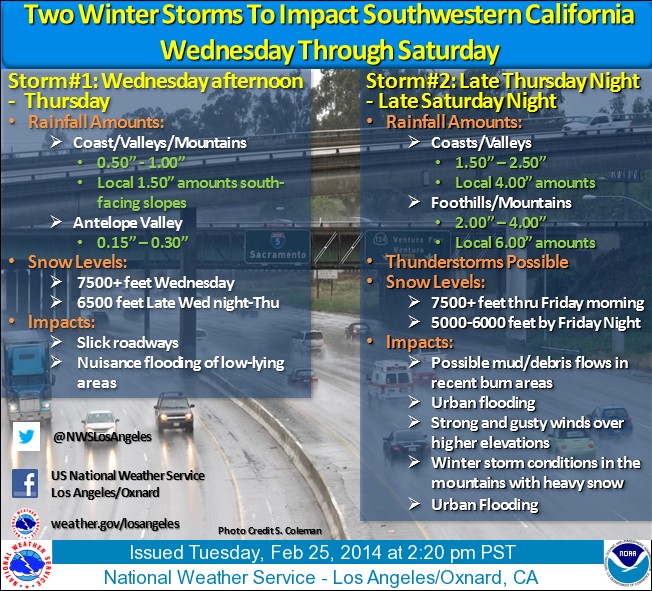
Here's more information from the National Weather Service out of Los Angeles/Oxnard, CA about the storm coming later this week:
See more from the NWS HERE:
Two storm systems are on track to impact southwestern California Wednesday through Saturday The first storm is expected to move across the area Wednesday afternoon through Thursday, bringing light to moderate rainfall to the area with about one half to one inch of rain for most locations and a few inches of snow accumulation above 7000 feet. From late Thursday night through late Saturday night, a second and much stronger system will affect the region with significant rainfall, heavy snow in the high mountain elevations, strong and gusty winds at times over higher terrain, scattered thunderstorms, and the threat of mud and debris flows in and below recent burn areas. One and a half to two and a half inches of rainfall is likely in coastal and valley areas, and two to four inches is likely in the foothills and mountains. Due to strong southerly flow ahead of the storm, locally higher amounts up to six inches are possible in favored upslope areas in the local mountains. Snow levels will remain high on Friday morning at above 7500 feet, but will drop to between 5500 and 6000 feet by Friday night, then drop further to 5000 to 5500 feet on Saturday. Snow accumulations of up to 1 to 2 feet will be possible mainly above 7000 feet. Winter storm conditions can be expected in the higher mountain elevations due to heavy snowfall and gusty winds. Additionally, this storm will be rather dynamic and thunderstorms may develop which could produce intense short-duration rainfall and small hail. Communities in and around recent wildfires, especially the Colby, Madison, Powerhouse, Madre, and Springs burn areas, will need to be alert for heavy and intense rainfall which could produce mud and debris flows. Drainage areas should be cleared of debris to help reduce the chance of urban flooding.
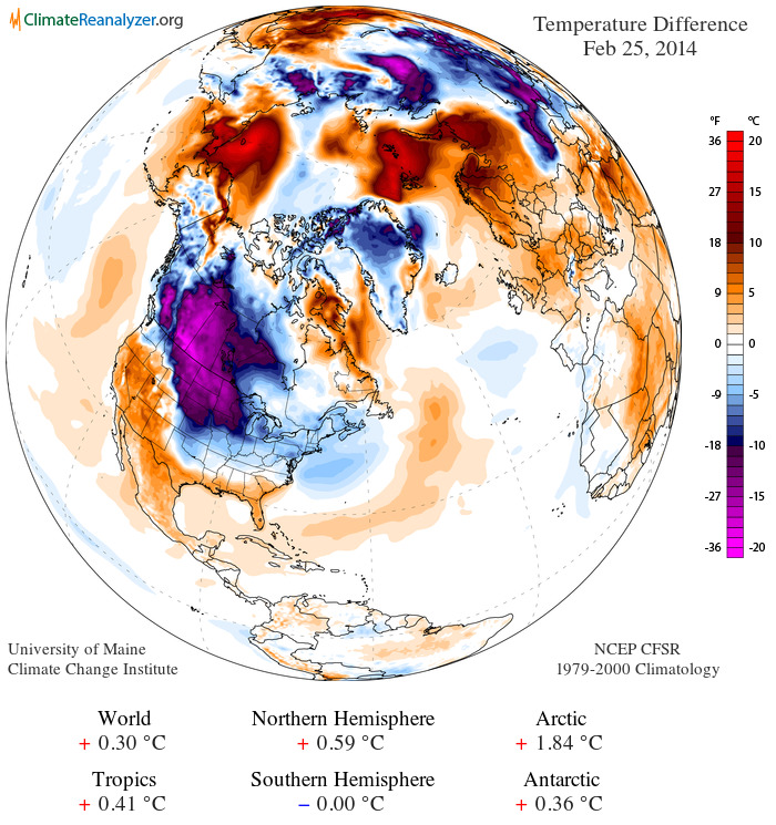
Significant Cold For End of February
Here's the temperature anomaly from February 25th, which shows a large blog of much colder than average air draining down into the Lower 48.
A Look Ahead
Here's the outlook for Thursday, which doesn't look much better as another surge of Arctic air settles south of the international border.
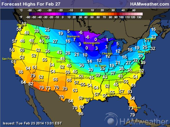
Highs Thursday
High temperatures on Thursday looks significantly colder across the Upper Mississippi Valley, while the warmth across the Southwest continues for now.
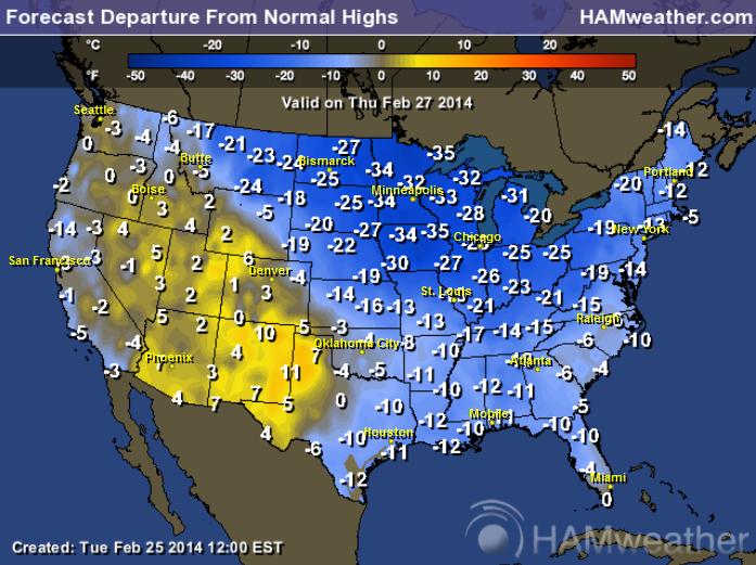
Highs From Normal Thursday
UGH!
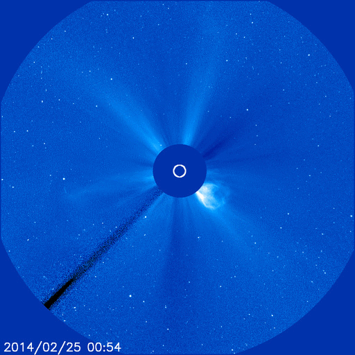
Northern Lights Potential
The strongest flare of the year thus far erupted on the sun on Tuesday. The good news is that this particular flare will only graze the Earth!
Radio emissions from shock waves at the leading edge of the CME suggest an expansion velocity near 2000 km/s or 4.4 million mph. If such a fast-moving cloud did strike Earth, the resulting geomagnetic storms could be severe. However, because its trajectory is so far off the sun-Earth line, the CME will deliver a no more than a glancing blow. NOAA forecasters expect a weak impact late in the day on Feb. 26th.
Read more from SpaceWeather.com HERE:
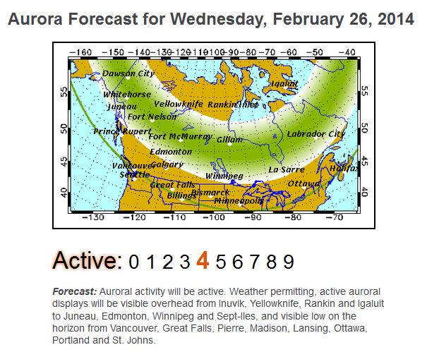
Northern Lights Forecast
Here's the latest northern lights forecast for Wednesday, which shows an active outlook.
See more HERE:
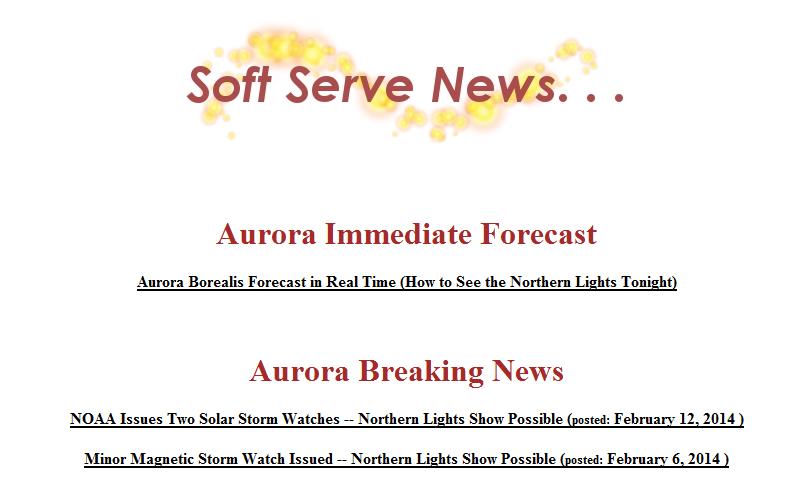
See also a more in depth look from Jim Thomas who runs SoftServeNews.com and a VERY bookmark worthy link when northern lights may be possible!
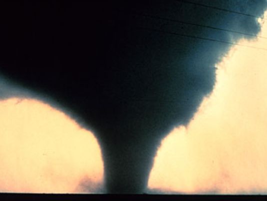
Giant Walls to Protect the U.S. form Tornadoes?
Now here's an interesting take on how to control tornadoes across the United States. This story comes from USA Today
"Forget the Great Wall of China… How about the Great Wall of ….. Kansas?
One scientist thinks we can protect parts of the central USA from ferocious tornadoes by building several gigantic walls across Tornado Alley:
"If we build three east-west great walls in the American Midwest .... one in North Dakota, one along the border between Kansas and Oklahoma to the east, and the third one in south Texas and Louisiana, we will diminish the tornado threats in the Tornado Alley forever," according to physicist Rongjia Tao of Temple University.
The walls would need to be about 1,000 feet high and 150 feet wide, he said. Tao is presenting his research next week at the annual meeting of the American Physical Society in Denver."
See the full story HERE:
Thanks for checking in and have a great rest of your week.
Don't forget to follow me on Twitter @TNelsonWNTV

No comments:
Post a Comment