By Todd Nelson
I think I can, I think I can, I think I can... I hope I can make it through this winter without going completely bat crazy. Even for the hardiest of Minnesotans, this continued Arctic nonsense can be a bit too much at times.
According to the National Weather Service, we have now just edged into the 10th coldest winter on record. This meteorological winter has been the coldest since 1979, which means that if you're less than 35 years of age and have lived in Minneapolis your entire life, you have never experienced a winter as cold as the present!
Interestingly, the official snow depth observation from the Minneapolis Int'l Airport was 24" last Friday making it the 5th highest snow depth on record during any meteorological winter day (December - February).
The seasonal snow tally so far this season is a generous 57.0" and nearly 17" above average to date. At this point, it appears that February will end on a very cold, but dry note, so as we continue to pad our cold weather stats, our snow stats will remain stagnant for the time being. Keep in mind that we'd have to get to 75.5" to get into the top 10 for seasonal snows. March averages nearly 15", stay tuned -Todd Nelson
____________________________________________________________
MONDAY NIGHT: A little light snow, nothing major. Low: -4. Wind: WNW 5-10. Wind Chill: -20F
TUESDAY: More Arctic sun. High: 6. Winds: WNW 5-10. Wind Chill: -20F early.
TUESDAY NIGHT: Mostly clear and cold. Low: -10. Winds: NW 10. Wind Chill: -25F.
WEDNESDAY: Frigid start. Harsh PM winds with a few PM flakes. High: 16
THURSDAY: Sunny, unreasonably cold. Wake-up: -12. High: -2
FRIDAY: Cold. A few PM flakes possible. Wake-up: -15. High: 4
SATURDAY: Meteorological Spring Begins! Arctic high pressure settles in. Wake-up: -10. High: 0.
SUNDAY: Cold, murky sunshine. Wake-up: -11. High: 9.
MONDAY: Storm track has been displaced south. Wake-up: -5. High: 15.
______________________________________________________________________
Snow on Vancouver Island
Thanks to my Aunt Sylvia for these pictures at Qualcom Beach on Vancouver Island. She's an avid golfer, so this is putting a wrench in her golf game. She says that winter has arrived!
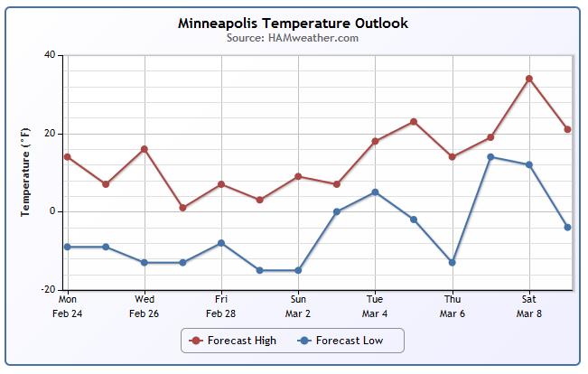
Minneapolis Temperature Trend
It'll be a cold end to February with temperatures bottoming out through the early part of March before any warming looks to take place.
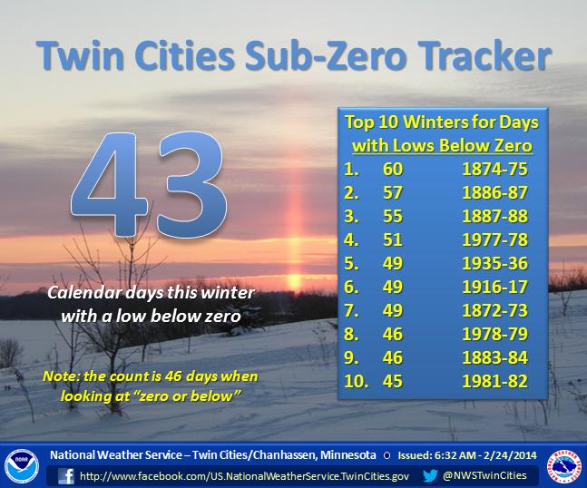
Sub-Zero Nights
As of Monday, February 24th, the Twin Cities has seen 43 sub-zero nights, which was nearing the top 10 winters for days with lows below zero. This number will increase through the rest of the week and we'll likely be be close to the top 5 if this cold weather continues by this Sunday!
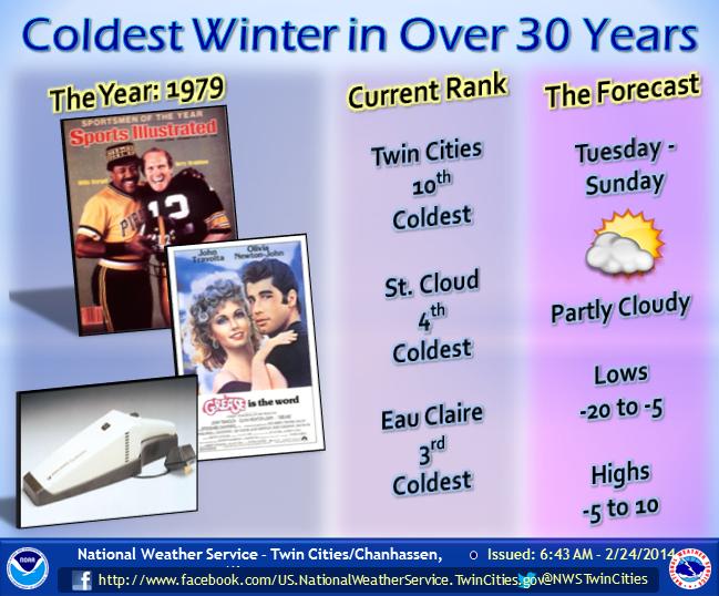
Another Funny from the NWS Twin Cities
I have to admit, the National Weather Service out of the Twin Cities has had a good sense of humor lately. Here's another good post from Monday about the cold winter we've had thus far. It's the coldest winter we've seen since 1979 and the 10th coldest in recorded history. St. Cloud has now seen their 4th coldest winter in recorded history.
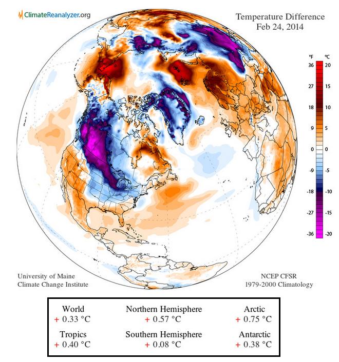
Arctic Plunge
Thanks to the University of Maine for the image below, which shows the temperature anomaly for Monday, February 24th and note the big blog of deep blue/purple from the much of North America nosing into the eastern two-thirds of the nation. Interestingly, according to the stats below, even though we were much colder closer to home, the globe as a whole was +0.33F above norm.
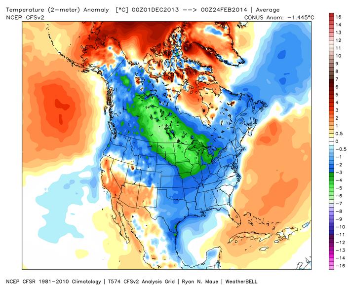
Cold Meteorological Winter
Keep in mind that meteorological winter stretches through the three coldest months on average for the northern hemisphere (December, January and February) The image below shows the temperature anomaly for that time frame over the northern hemisphere. Note how cold that time period was for a large chunk of the continent.
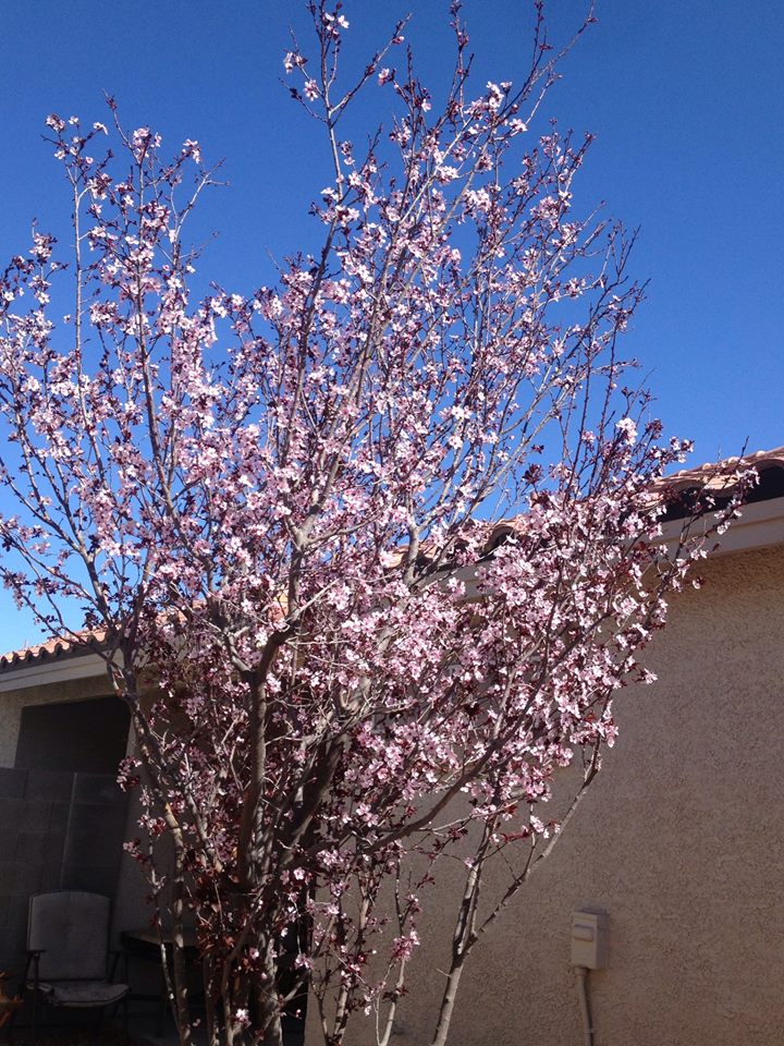
Signs of Spring
Thanks to my good friend Stephanie Trindade for this picture out of Las Vegas, NV. I think she's just trying to rub it in, but nice to see some signs of spring no matter where it is located! Hopefully it won't be too long for this to take place it other areas of the country!
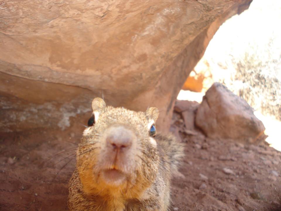
SELFIE
Not sure if you've heard of the new catchphrase "Selfie" or not, but this one is great! It's a Squirrel Selfie! Thanks the Zion National Park for this:
See more HERE:
More Signs of Spring
Here's an amazing timelapse of storms. It's definitely worth a look!
"Photographer Nicolaus Wegner loves a good storm chase—one of several reasons he produced a new time-lapse video called "Stormscapes.""
See more HERE:

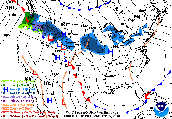
Weather Outlook
The weather outlook through PM Thursday shows a little light snow from the midsection of the nation transitioning into a little more rain potential across the southeastern U.S. and more snow for the northeastern part of the U.S. - also note the heavier moisture moving into California at the end of the loop!
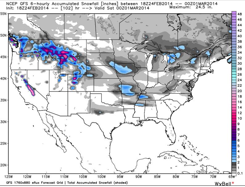
Snowfall Potential
Thanks to WeatherBell Analytics for the image below, which shows the GFS snow potential through PM Friday. Other than some light snow chances across the eastern two-thirds of the nation, the biggest threat for heavy snow appears to be in the higher elevations in the western U.S.
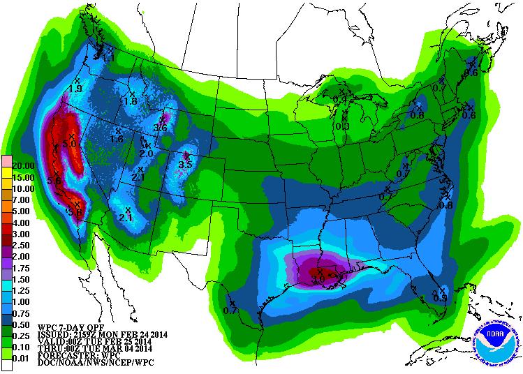
Precipitation Outlook
I am most intrigued by the recent outcome in the precipitation department for the western U.S. and especially across California over the next 7 days. Although this rain won't be a drought busting event, it will certainly help! According to NOAA's HPC 7 day precipitation forecast, some areas in California could see +5" by early next week!
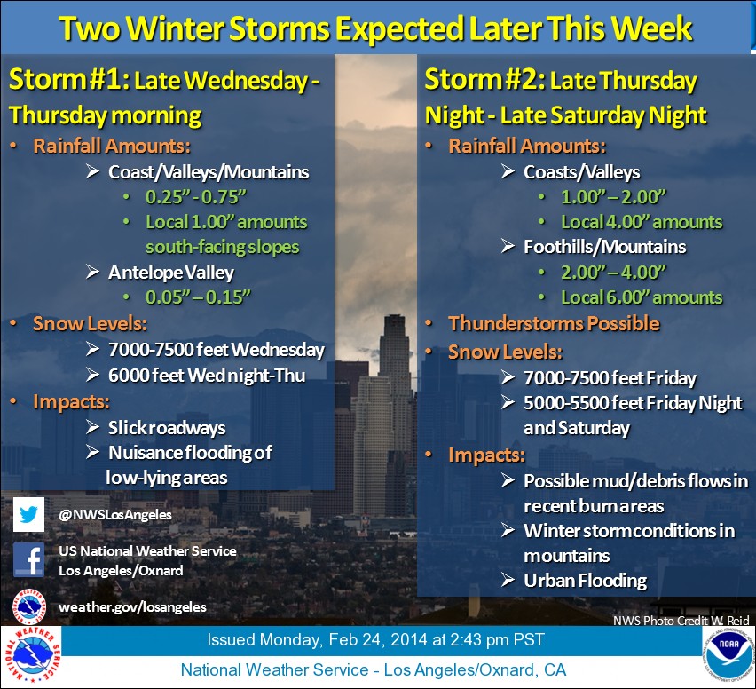
Much Needed Rain
Here are the details on the rain chances this week from the NWS in Oxnard, CA:
...Two Storm Systems to Bring the Most Significant Rains of the Winter...
TIMING
Storm #1 - Wednesday afternoon/evening through midday Thursday.
Storm #2 - Friday morning through Saturday
CONFIDENCE
High confidence on timing; moderate on rain amounts. Computer model data has been very consistent with the storm tracks since last Thursday, Feb. 20, therefore, forecasts have not deviated.
MAIN IMPACTS
Storm #1 - This is the weakest storm. No significant impacts outside of the typical slick roadways and minor clogged storm drains are expected Wednesday afternoon through midday Thursday.
Storm #2 - This is the strongest storm of two. Main impacts will be the potential for heavy downpours in and near thunderstorms. This could lead to mud and debris flows near recent burn scars (Colby, Madison, Springs), and urban flooding of roadways and drainage systems Friday through Saturday. Snow accumulations above 5000 feet on Saturday could lead to road closures or chains required on vehicles. In addition, gusty winds to 50 mph in the mountains could result in reduced visibilities due to fog and/or blowing snow.
AMOUNTS
Storm #1 - 0.25-0.75” in most areas with upwards of 1” for the Santa Ynez and San Gabriel Mountain slopes.
Storm #2 - Widespread 1-2” for coasts and valleys and 2-4” with locally 6” for mountains. Locally heavier rainfall totals can be expected due to the showery nature of the event lingering on Saturday.
SYNOPSIS
Two storm systems in one week will be the first of it’s kind this winter. Storm #1 will be ordinary with minimal impacts expected late Wednesday through midday Thursday. Storm #2 will be much stronger bringing greater impacts Friday through Saturday. We will be monitoring this system closely due to the potential for thunderstorms with heavy rain. Brief downpours could create mud and debris flows near recent burn scars along with urban flood problems due to clogged drainage systems.
It is likely that we will see higher rainfall amounts from these two storms than we have received in total going back to July 1st. Even with the significant rains expected, we would need 5-7 equivalent storms in March and April to get back to a “normal” rainfall season."
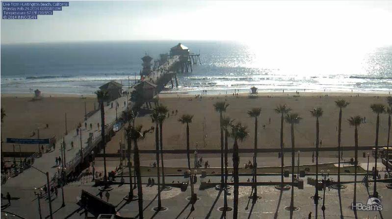
Huntington Beach, California
Take a look at this stunning webcam view from Monday afternoon from Huntington Beach, California. This webcam will likely look much different later this week as much needed precipitation heads into the region.
See more from hbcams.com HERE:
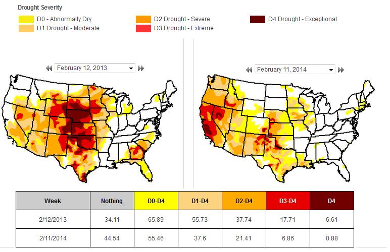
Drought Comparison
It has been extremely dry across the western half of the country for a number of weeks and months. Here's the difference in the drought from February 2013 to February 2014. Note the at this time last year, the biggest drought was across the Plains. While there is still some significant drought in the Plains, the worst has shifted into the western U.S.
Thanks for checking in and have a great rest of your weekend
Don't forget to follow me on Twitter @TNelsonWNTV

No comments:
Post a Comment