By Todd Nelson
My golf doctor was wrong! According to avid golfer and 'common' voice on midday radio, my GDS or Golf Deprivation Syndrome I wrote about in early February, was to be cured by "taking 2 pro v1s and calling him in the morning." Not only has it not been cured, but it seems to have got worse! My aches and pains have increased from recently shoveling 10" of snow and I have now started to shiver uncontrollably due to the drafty Arctic air that won't seem to quit this winter. What gives?
According to the Minnesota State Climatology Office, this winter has now entered the "Severe Winter" category. By assigning numbers for the intensity of cold, amount of snow and snow depth, a "Winter Misery Index" number is given to help gauge the severity of any given winter. This winter has been the most severe since the 1980s!
I don't see much improvement in the week ahead. Drag out the heavy winter artillery out of the back of the closet again. We will likely be in the top 10 for winters with days below zero by this week. It is possible that we could near the top 5 in that category by the end of week!
By the way, Meteorological Spring starts next Saturday... So what!
_________________________________
SATURDAY NIGHT: Clear and cold. Low: -1. Wind: W 10. Wind Chill: -15F
SUNDAY: Blue sky, only partially numb. High: 13. Wind: W 10-15. Wind Chill: -15F
SUNDAY NIGHT: Partly cloudy and cold. Low: -4. Wind Chill: -20F
MONDAY: Flurries & light snow developing. Coating - 1" High: 11
TUESDAY: Some sun, turning colder again. Wake-up: -7. High: 6
WEDNESDAY: Cash in frequent flier miles. Patchy clouds, reinforcing clipper. Wake-up: -10. High: 8
THURSDAY: Sunny, unreasonably cold. Wake-up: -11. High: 2
FRIDAY: Cold, clouds thicken late. Wake-up: -10. High: 10.
SATURDAY: More clouds with light snow chances. Wake-up: -1. High: 15.
_________________________________
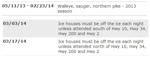
2013 Walleye Season Ends
According to the MNDNR, the 2013 Walleye Season ends Sunday, February 23rd. You will also no longer to legally keep sauger or northern pike until the 2014 opener on May 10th, about two and half months away. Also ice houses much be removed every night starting in early March. Depending on location, you may be able to keep your house on longer. See the full list of dates from the MN DNR HERE:
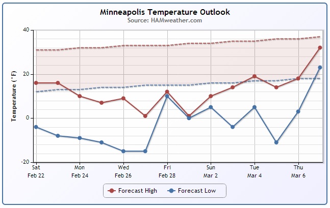
Minneapolis Temperature Trend
UGH! When will it end?? After last weeks brief reprieve from the bitter Arctic temps this winter, we're heading back into the painfully polar stuff through what appears to be early March! YUCK!!
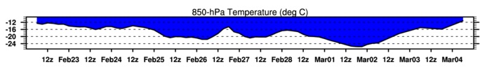
850mb Temperature Trend
Here's another look at the cold snap from just a few thousand feet off the ground. The 850mb level suggest temperatures in the sub-freezing category through early March. In some cases, temperatures are much below sub-freezing, so I think it's safe to say we'll all be shivering for the next several days.
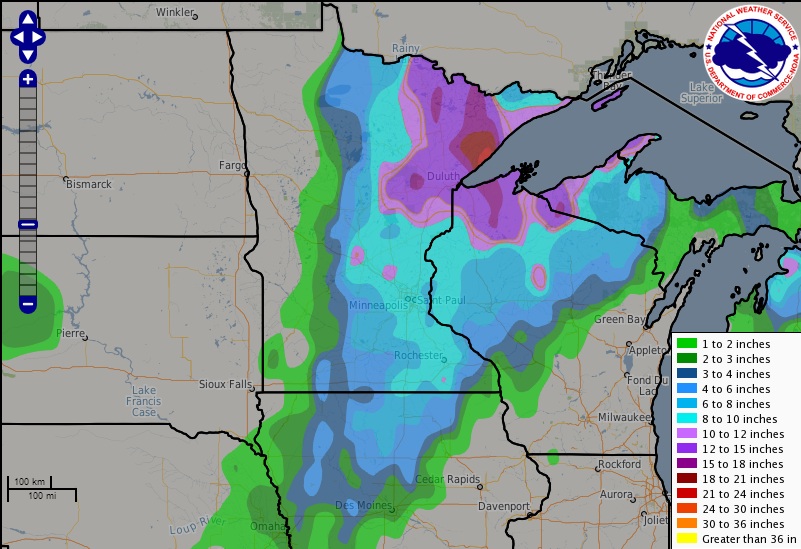
Snow Analysis
Here's the snowfall analysis from our latest storm system. Take a look at the massive snow blob over Northwest Wisconsin and Northeast Minnesota!
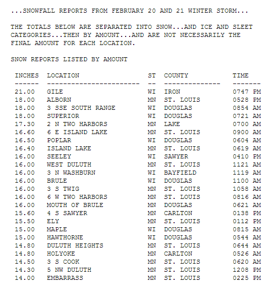
Snow Totals
Here are some of the heaviest snow tallies from the event across NW Wisconsin and NE Minnesota. These numbers are reported from the NWS Duluth:
See more from the NWS Duluth HERE:
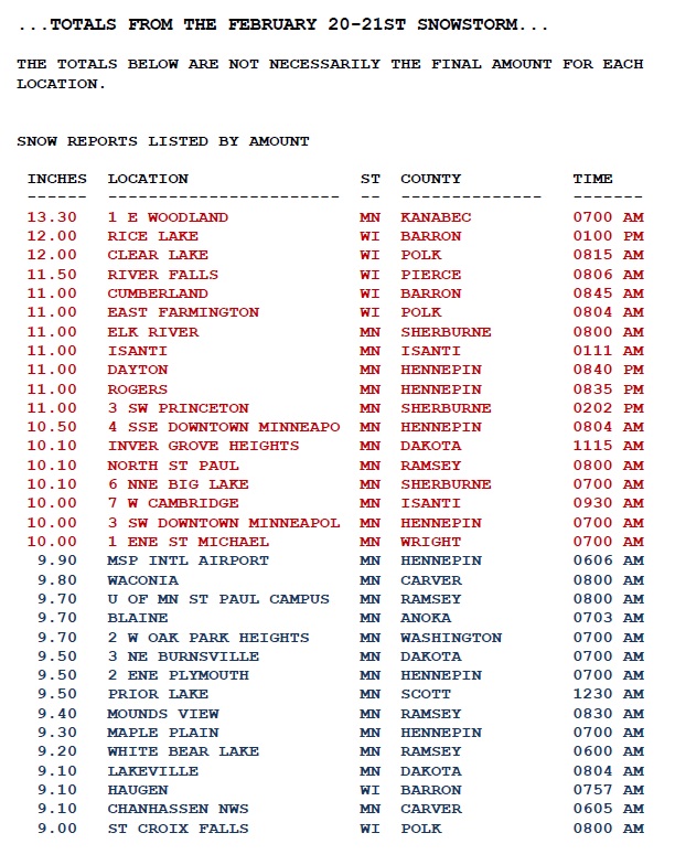
Here's a list of some of the highest tallies from the NWS Twin Cities CWA:
See more about the storm from the NWS Twin Cities HERE:
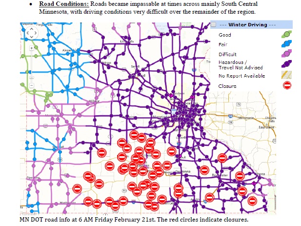
Road Conditions
Road conditions have been ridiculous lately... BE CAREFUL out there!! Thank goodness for a higher sun angle, which is about as strong now as it was in mid October; that may help a bit to melt some of the snow and ice off your driveway and some of the roads. Don't expect any dramatic change in those roads until temperatures really warm, which may be a while.
See the current road conditions HERE: Minnesota Wisconsin
Thanks to MNDOT for the image below, which showed road conditions from AM Friday
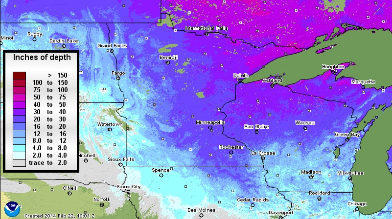
Snow Depth
If the mountainous snowbanks around aren't any indication of how much snow we've had recently, take a look at this impressive snow depth map across the Upper Mississippi Valley. There are a number of locations with at least a foot of snow on the ground, however there are a number of locations with nearly 2 feet of snow on the ground or more! Spring along the Minnesota North Shore should be interesting if the spring snow melt is quick. Those rivers and streams are going to be raging! As of midday Saturday, there was 23 inches of snow on the ground at the Minneapolis International Airport.
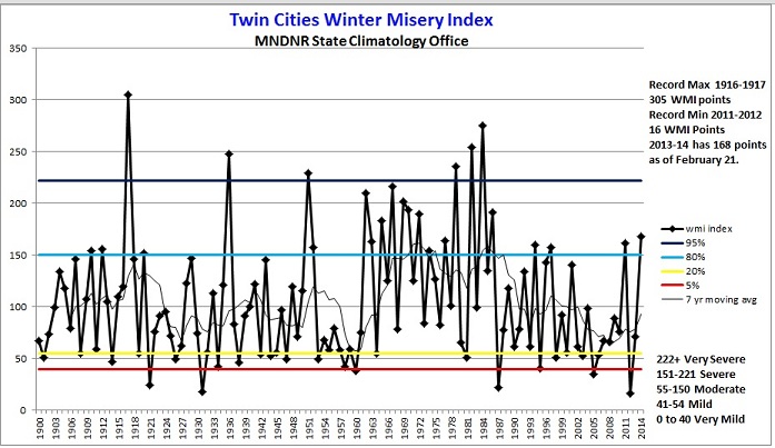
Minneapolis Winter Misery Index
Thanks to our recent cold and snowy weather, the Winter Misery Index that comes from the Minnesota State Climatology Office, we have now moved into the "Severe Winter" category.
"So far as of February 21, 2014 the WMI for the winter of 2013-14 in Twin Cities is 168 points, or in the "severe winter" category. Of course there is quite a bit of winter left. The lowest WMI score was the winter of 2011-2012 with 16 points. The most severe winter is 1916-1917 with 305 WMI points. How many WMI points will this winter score? stay tuned!"
See more from the Minnesota State Climatology Office HERE:
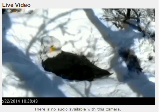
Eagle Cam!
Thanks to the MNDNR for this live camera of a Bald Eagle that is currently sitting on Bald Eagle eggs in a nest! Thanks to the recent snowstorm, the nest is covered in white!.
See the LIVE feed HERE:
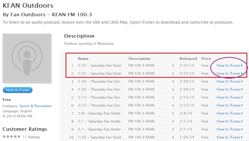
Eagle Insight
I had a chance to listen in on KFAN's FAN Outdoors radio show Saturday morning and one of their very knowledgeable guests, Naturalist Stan Tekiela (Twitter: @StanTekiela), talked about the eagles in great details at the end of the first hour. Check out the Podcast from Saturday, February 22nd, 2014 HERE: Not only is Stan an expert on eagles, but he seems to be an outdoor encyclopedia!
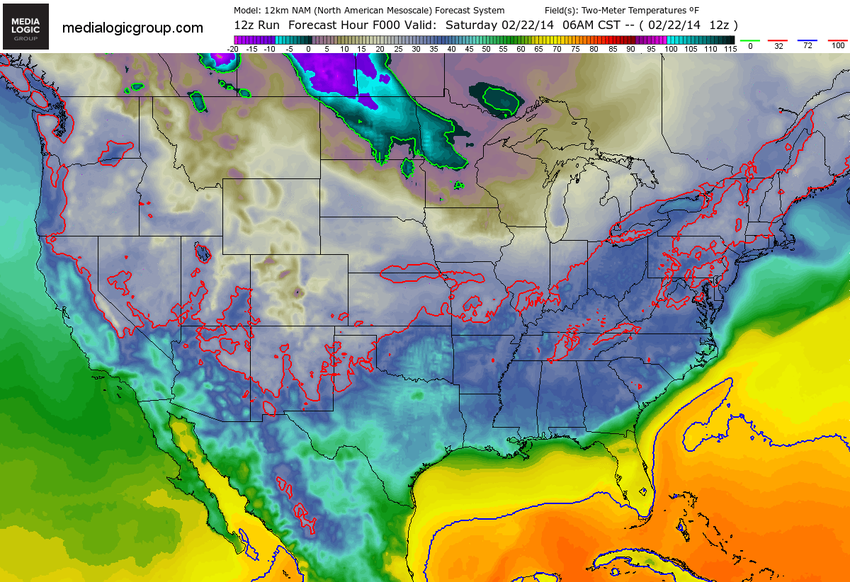
Cold Weather Returns
Looks at all the Arctic colors moving back in across the Lower 48. This forecast temperature loop brings us into early next week with the coldest of the cold from the High Plains to the Great Lakes Region. Keep in mind that much of the eastern two-thirds of the nation will be colder than average as head into next week.
Temperature Breakdown
Here's a look at Arctic plunge through the week ahead. Sunday appears to be quite chilly, but look at how cold it will be by Thursday!
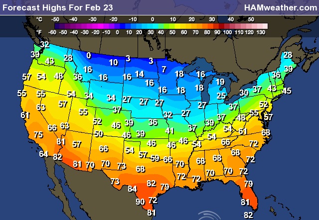
Sunday Highs
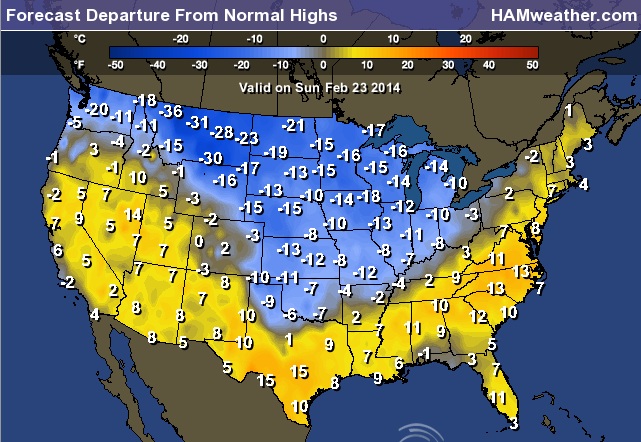
Sunday Highs From Normal
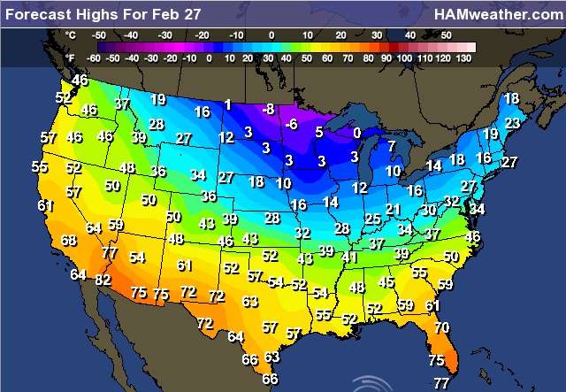
Thursday Highs
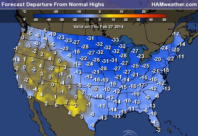
Thursday Highs From Normal
Continued Cold Through Early March
After the big snow and severe weather event we had late last week, temperatures across the eastern two-thirds of the nation look to take a nosedive through the early part of March. Here's the outlook from NOAA's Climate Prediction Center.

Weather Outlook
The weather outlook into early next week looks fairly quiet compared to what we ended last week with. As cold air spreads throughout the eastern two-thirds of the nation, clipper systems will make a comeback. Note the snow spreading into the Midwest from the Northwest. This will likely bring some light snow accumulations along its path.
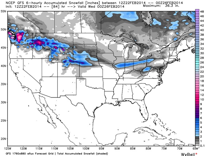
Snow Potential
Here's the snowfall potential through early next week as our next clipper system crosses the country. Note that snowfall amounts look much heavier in the Northwest than they do in the eastern part of the country. However, note the snow streak over across the Central Plains. Shovelable to Plowable snow is looking more and more likely for some folks there.
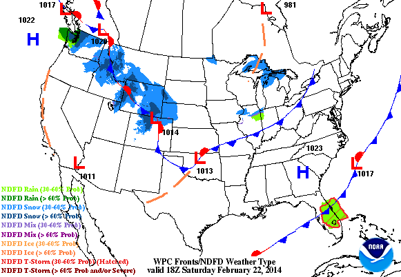
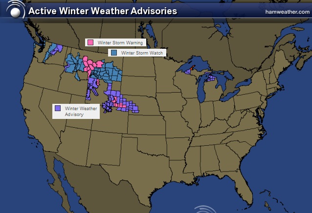
Winter Weather Headlines
The National Weather Service has issued winter weather headlines for areas shaded in color below. Mountain snow could near +12" by early next week, while snow in the Central Plains could near 6" by early next week.
Keep an eye on latest watches and warning from the National Weather Service HERE:
Recent Severe Outbreak
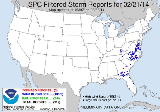
According to NOAA's Storm Prediction Center, there were 23 PRELIMINARY tornado reports on Thursday and 5 on Friday. Here are all the reports from that multi-day severe weather outbreak.
Thursday
One of the tornadoes in Missouri caused some injuries as a mobile home was overturned onto a vehicle in the town of Pemiscot, MO. There was also 1 fatality in Ringgold, IA as a strong wind gust blew over a 30ft. conveyor belt
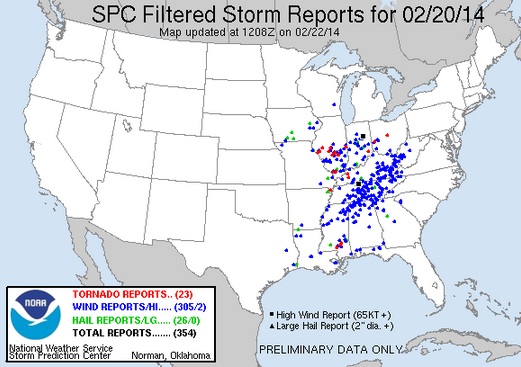
Friday
2014 Tornado Count
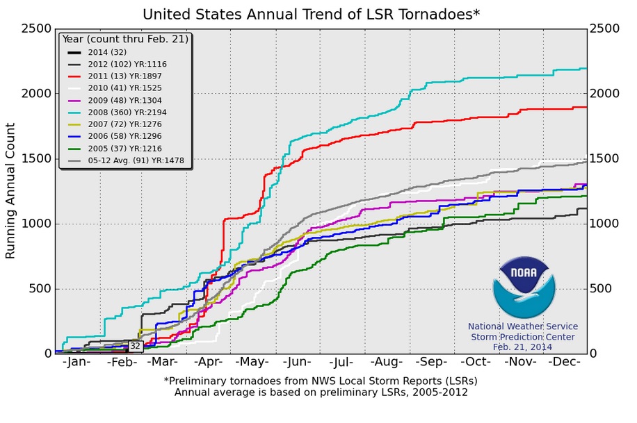
According to NOAA Storm Prediction Center, there have been 32 PRELIMINARY tornado reports so far in 2014. According to the 2005 to 2012 average, we are below average to date, which is 91. Note that getting off to a slow start doesn't always mean a quiet year. Take a look at 2011, through February 21st, there had only been 13 tornadoes, but the year ended up with nearly 1900 tornadoes!
Thanks for checking in and enjoy the rest of your weekend!
Don't forget to follow me on Twitter @TNelsonWNTV

No comments:
Post a Comment