By Todd Nelson
I don't know about you, but it's time we say goodbye to this sub-par March. Of course, March weather in Minnesota isn't always one to write home about, but it beckons change and I hope that change occurs sooner rather than later.
As we recover from one of our warmest weekend since late last year, we are greeted by yet another storm system that is threatening to dump heavy snow across parts of the Upper Midwest. The good news is that the best chance for shoveable snow will stay well to our north and west. However, we still will see a little wintry mix on the backside of this potent low as it quickly moves to our northeast late tonight/Tuesday.
These are pretty classic spring storms. Heavy, wet snow on the northwest side of the storm, while heavy rain and thunder sneaks in on the southeast side of the storm. Interestingly, southern Minnesota could wind up in this region today, so don't be surprised if you hear a brief rumble of thunder as the rain comes down!
Yes, we are limping into Spring this year, but I am confident that we'll have more days like Sunday in the month ahead. Keep in mind that the average high April 1st is 50F; April 30th it's 65F!
=============================
SUNDAY NIGHT: Mild. Becoming mostly cloudy. Low: 41. Winds: NNE 10-15.
MONDAY: Breezy. Rain and possibly and rumble of thunder across southern MN? Heavy snow across the northern and western MN. High: 56. Winds: ENSE 5-15.
MONDAY NIGHT: Rain changes to snow. Less than 1" slush possible. Best chance of heavy snow accumulations across the northern half of the state. Low: 21. Winds: WNW 15-25.
TUESDAY: April Fools' Day. Breezy with an AM flurry. Clearing and cooler. High: 35. Winds: NW 10-20
WEDNESDAY: Sunny start, clouds thicken late. Wake-up: 22. High: 40.
THURSDAY: Growing rain/snow threat Wake-up: 29. High: 42.
FRIDAY: Chance of sloppy snow. Wake-up: 28. High: 39.
SATURDAY: Another nice Saturday? Bring it! Wake-up: 25. High: 44.
SUNDAY: Partly sunny, feels warmer. Wake-up: 28. High: 48.
============================
This Day in Weather History
March 31st
1896: A strong snowstorm dumps 13.5 inches of snow at Maple Plain. Vivid lightning in storm with 10-12 flashes per minute. Visibility was down to less than one block. The temperature was 57 at Maple Plain the day before.
1843: The low temperature at Ft. Snelling plummets to -11.
=============================
Sunrise/Sunset Times
March 31st
SUNRISE 655 AM
SUNSET 739 PM
==============================
Moon Phase for March 31st at Midnight
1.5 Days Since New Moon

===============================
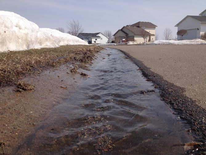
Sunday's Big Melt
We certainly lost a lot of snow on Sunday with temperatures as warm as they were. It sure was nice to see running water again!
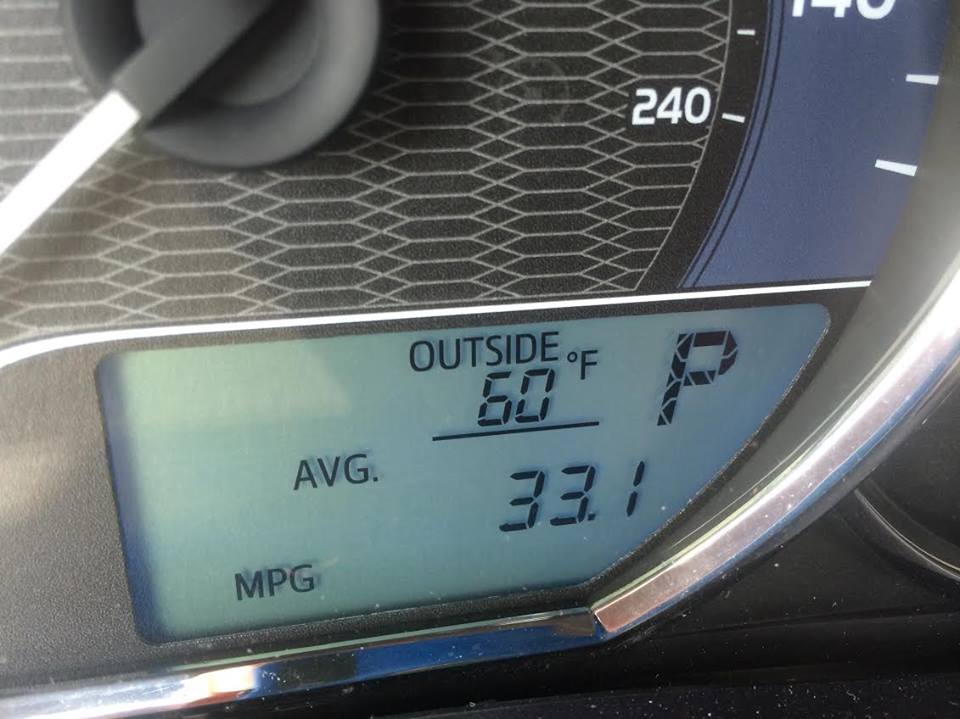
First 60F Since October 13th!
Here was the temperature and dewpoint trend from the Minneapolis/St. Paul International Airport on Sunday. Temperatures started off mild in the morning and eventually made it to the 60s! Keep in mind that we haven't see a 60F day since October 13th, when the mercury topped out at 61F!
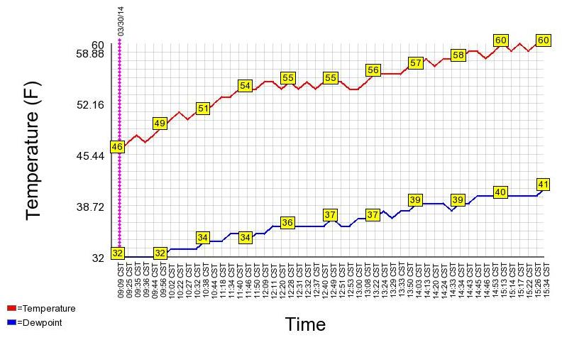
Minneapolis Temperature Trend
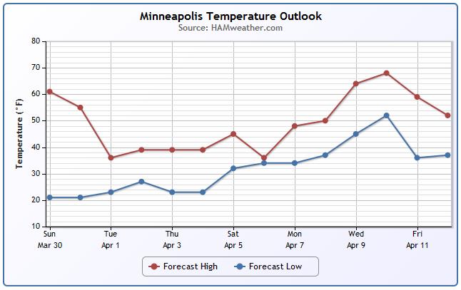
After a glorious Sunday, temperatures will begin to take a big of a tumble through the week ahead. Not only will it be cooler, but we'll also have a chance of snow over the next 5 days.
Weather Outlook
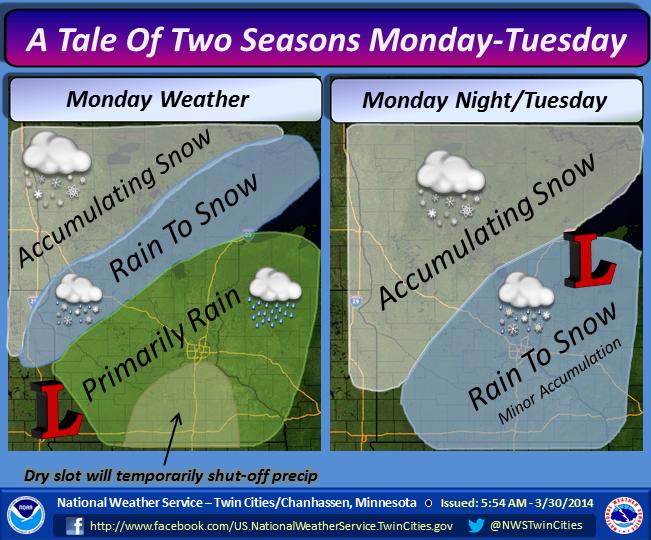
Here's a good look at how the early week storm system will unfold across Minnesota from the National Weather Service.
"A powerful storm will move across the region Monday through Tuesday. Southern Minnesota and west central Wisconsin will experience spring-like weather on Monday before the backside of the system delivers more winter-like weather late Monday night through Tuesday. Snow accumulation will be minor across most of southern Minnesota and west central Wisconsin."
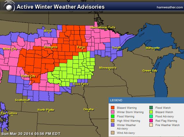
Winter Weather Headlines
...A MAJOR SPRING STORM IS EXPECTED MONDAY INTO TUESDAY...
AS IS TYPICAL WITH SPRING STORMS...THERE REMAINS A FAIR AMOUNT OF UNCERTAINTY WITH THIS STORM SYSTEM. THE MODELS ARE COMING INTO BETTER AGREEMENT THAT THE HEAVIEST SNOW WILL FALL ACROSS THE NORTHWESTERN THIRD OF MINNESOTA...BRINGING THE POTENTIAL FOR A FOOT OF SNOW INTO THE INTERNATIONAL FALLS AREA. FURTHER TO THE SOUTHEAST...INCLUDING BRAINERD...HIBBING...ELY...DULUTH... HINCKLEY AND SUPERIOR...SNOWFALL AMOUNTS WILL LIKELY BE MUCH LESS THROUGH MONDAY NIGHT AND EARLY TUESDAY. THE BIG CONCERN NOW IS THE POTENTIAL FOR SIGNIFICANT ICE ACCUMULATIONS. FOR THIS REASON...WE HAVE CONTINUED THE WINTER STORM WATCH FOR THE SAME GENERAL AREA. IF LATER MODELS CONTINUE TO SHOW A BIT WARMER TREND...WE MAY NOT SEE AS MUCH ICE IN EASTERN AND SOUTHERN AREAS OF THE WATCH...BUT AT THIS POINT THAT POTENTIAL STILL EXISTS. THE COMMUTE ON MONDAY MORNING MAY BE TRICKY...ESPECIALLY NEAR LAKE SUPERIOR...WHERE COLD NORTHEAST WINDS WILL BLOW ACROSS THE LAKE SUPERIOR ICE SHEET...BRINGING LOCALIZED COOLING TO THE LAKE SUPERIOR BASIN. THIS IS DEFINITELY A STORM TO KEEP AN EYE ON...AS IT HAS THE POTENTIAL FOR HEAVY SNOW IN NORTH CENTRAL MINNESOTA... AND ICE WITH SOME SNOW ACROSS THE REMAINDER OF MINNESOTA AND FAR NORTHWESTERN WISCONSIN.
...WINTER STORM DEVELOPING FOR MONDAY EVENING INTO TUESDAY... .A LOW PRESSURE SYSTEM WILL DEVELOP ACROSS THE CENTRAL PLAINS TONIGHT AND MOVE NORTHEAST ACROSS SOUTHERN MINNESOTA TO NORTHWESTERN WISCONSIN BY TUESDAY MORNING. THIS STORM WILL BRING PRIMARILY RAIN MONDAY...HOWEVER ONCE THIS SYSTEM STARTS TAPPING COLDER AIR MONDAY EVENING...THE RAIN WILL CHANGE TO SNOW ACROSS WEST CENTRAL MINNESOTA. SNOWFALL AMOUNTS OF 2 TO 4 INCHES ARE EXPECTED. IN ADDITION...STRONG WINDS WILL DEVELOP AS THE SYSTEM MOVES OFF TO THE NORTHEAST WITH GUSTS AS HIGH AS 50 MPH...RESULTING IN CONSIDERABLE BLOWING AND DRIFTING SNOW. THE BLIZZARD WATCH FOR WESTERN MINNESOTA INCLUDES THOSE AREAS ALONG AND WEST OF A LINE FROM ALEXANDRIA TO GRANITE FALLS.
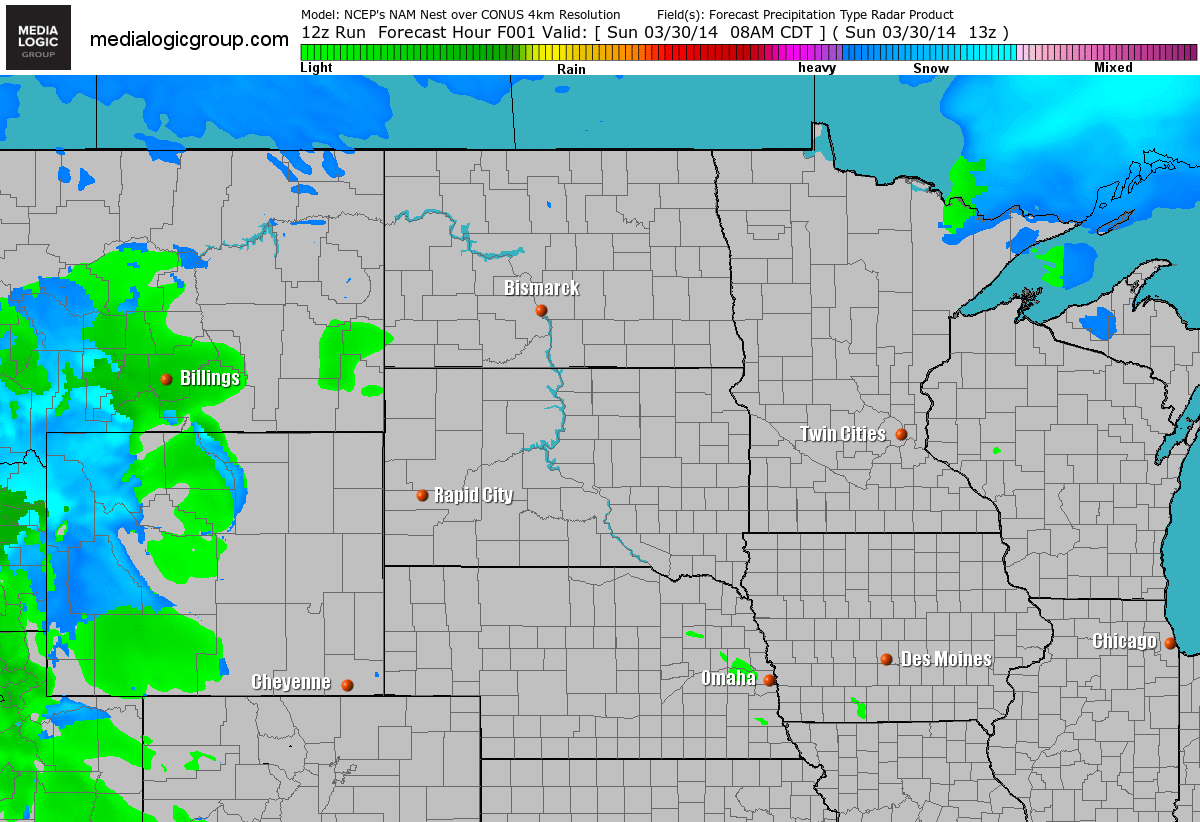
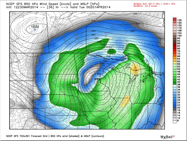
Weather Outlook
Watch the storm wrap up over the Midwest through the early week. Note that the best chance of snow appears to be from the Dakotas to northern Minnesota. Note the yellow colors that show up near the Twin Cities around midday Monday and through the afternoon hours. These yellows indicate a little instability and the possibility of thunderstorms!
Snow Potential
The storm system appears to have shifted even farther north than previous runs last week. The heaviest snow looks to be setting up from near Bismarck, ND to International Falls, MN.
Storm Outlook
Here's a glance at the storm around 7pm Monday. Note that the center of the is forecast to past nearly directly over the Twin Cities. This particular storm track keep snow rather low for the Twin Cities. In order for the Twin Cities to see substantial snow, we'd have to see a storm track from near Des Moines, IA to La Crosse, WI to Marquette, MI. Because the storm track is expected to be a little farther north, we should pick up more rain with just a little snow on the tail end of the storm.
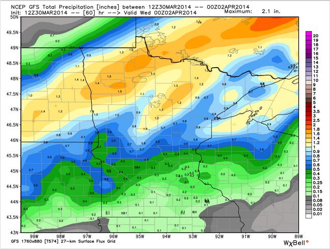
Total Precipitation
This looks to be a fairly water-logged storm system with as much as an inch or more of total liquid across the northern part of the state. The Twin Cities appears to be around the 0.3" range, which could be accompanied by a little thunder by Monday as well!
========================
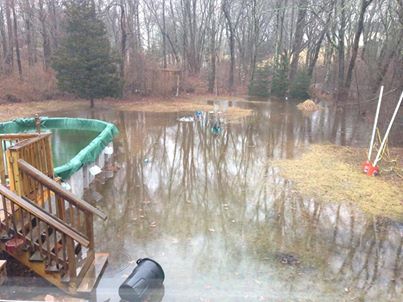
Active Weekend in the Northeast
This is what a months worth of rain looks like in less than 24 hours. Thanks to @jacobdog97 for the picture below out of Westerly, RI.
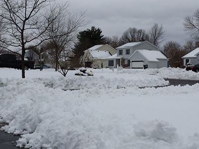
Heavy Northeast Snow
While some folks were dealing with heavy rain, others were dealing with heavy snow. Take a look at this picture from Rochester, NY! Thanks to Donny Rodgers who said that there was no snow on Saturday and then this on Sunday!
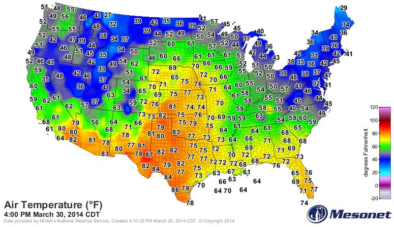
Sunday Temperatures
It was nice to see temperatures in the middle part of the country showing more spring-like signs again. The image below was the temperature outlook at 4pm CDT Sunday and note how far north the 60s and 70s were!
Winter 2013-2014 Perspective
Sunday temperatures across parts of the Midwest were some of the warmest readings we've seen since late last year. The 2013-2014 winter was quite a bit colder than average from Canada to the eastern two-thirds of the nation, but NOAA sheds light on how our cold winter compared to the entire globe.
See more from NASA's Earth Observatory HERE:
"For many residents of North America, the winter of 2013-14 has felt like one of the coldest in many years. Waves of Arctic air brought extended periods of cold weather and above-average snowfall to the middle and eastern portions of the United States and Canada. Seven Midwestern states had one of their top-ten coldest winters, and the Great Lakes were chilled until they reached nearly 91 percent ice cover. Even portions of Mexico and Central America were cooler than normal.
But human memory is not a scientific measure, and long-term perspective tends to get lost in everyday conversation and news coverage. The winter of 2013-14 followed two winters that were significantly warmer than the norm, which likely made this season feel worse than it was. Researchers at the U.S. National Climatic Data Center (NCDC) reported that the average temperature of the contiguous U.S. for the winter was just 0.4° Celsius (31.3° Fahrenheit), about 1°F below average."
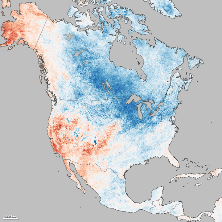
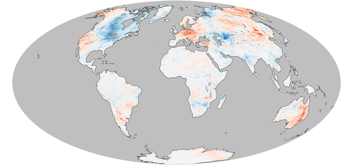
"The map below puts the North American winter in wider context. On a global scale, land temperatures for the December through February period were actually the tenth warmest in the modern record, according to NCDC, 0.87°C (1.57°F) above the 20th century average."
"Far eastern Asia, particularly China and eastern Russia, were significantly warmer than normal. In Europe, Austria and The Netherlands observed the second warmest winters in their records, and Switzerland its third warmest. With temperatures as much as 5°C above normal, spring crops and plants began sprouting several weeks early across much of Europe. And in the southern summer, the extended heat waves in Australia and Argentina stand out."
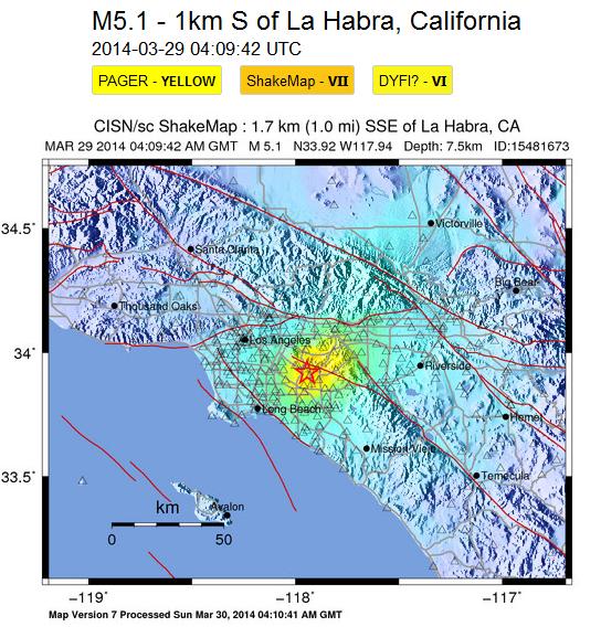
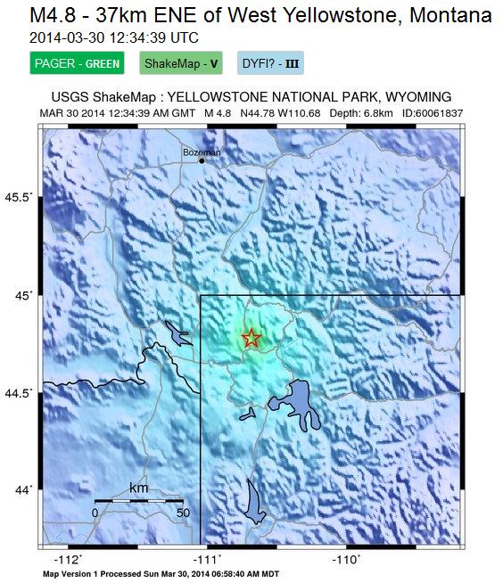
Recent Earthquakes
It seems as if there have been a string of earthquakes over the recent weeks and this weekend was another fairly active weekend. There were two quakes in the western part of the country; a 5.1 magnitude quake near Los Angeles, CA on Saturday and a 4.8 magnitude quake in Yellowstone National Park!
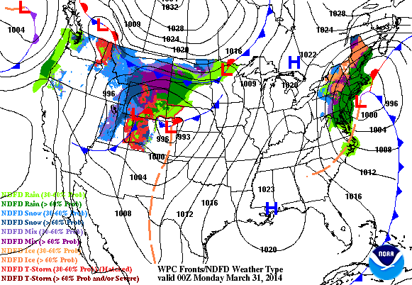
Weather Outlook
As our latest storm system exits the Northeast another storm system takes shape across the Midwest. The next storm in the Midwest will be responsible for heavy snow and blizzard conditions across the Dakotas and parts of Minnesota.
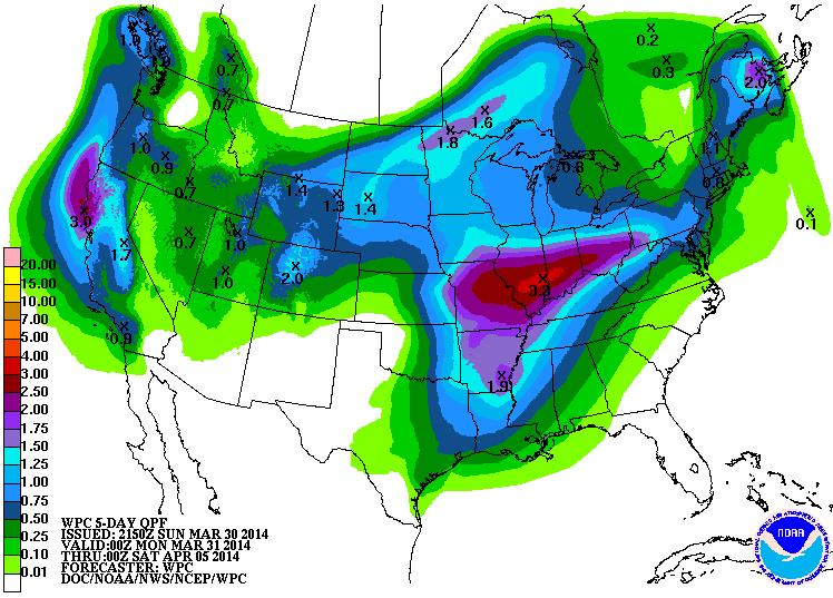
Precipitation Outlook
According to NOAA's HPC the 5 day precipitation forecast suggests heavier blobs of moisture across the western part of the country and again through the middle part of the country. The end of March/early part of April looks quite active across much of the nation, except for much of the Desert Southwest.
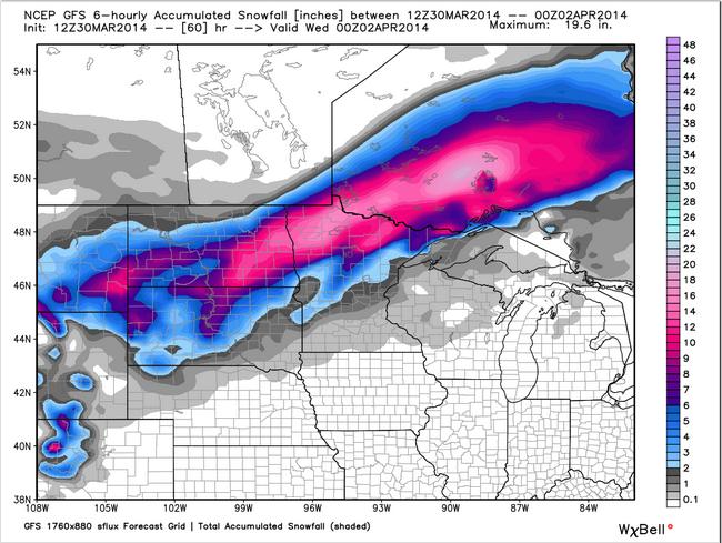
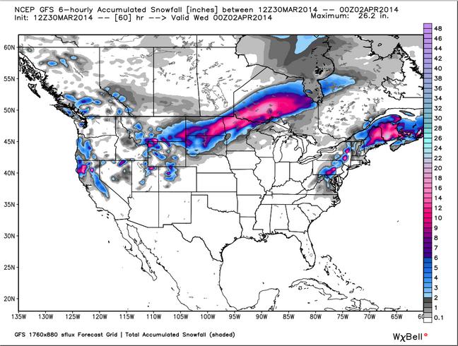
U.S. Snowfall Potential
Here's the snowfall potential from AM Sunday through PM Tuesday
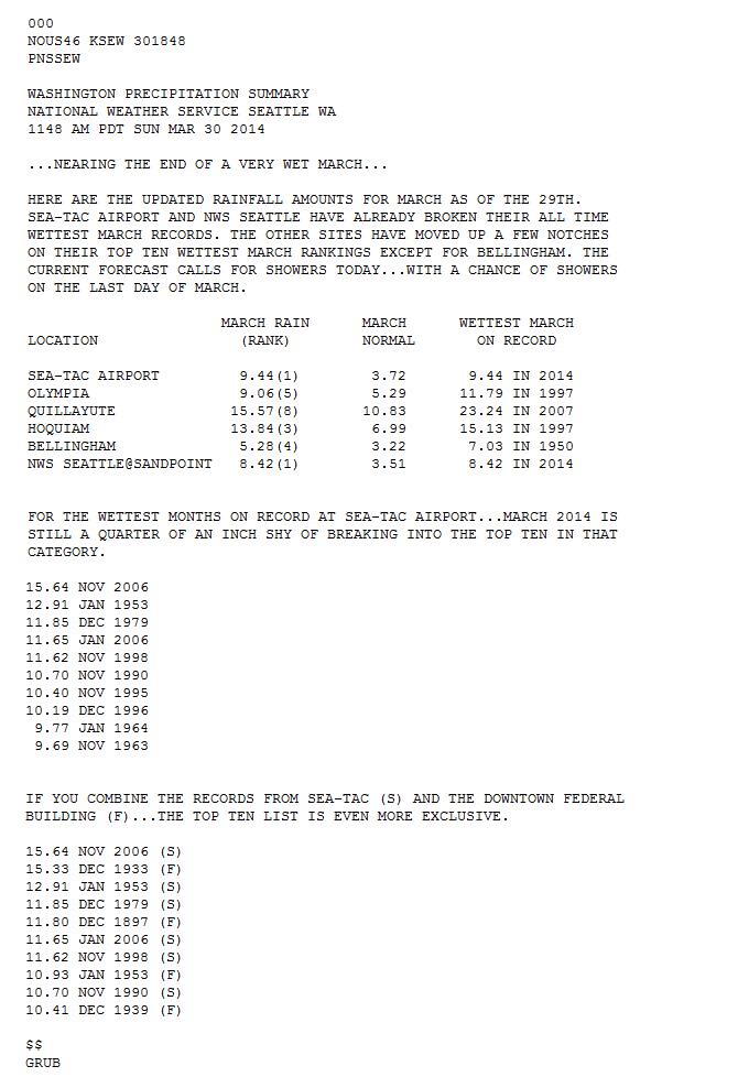
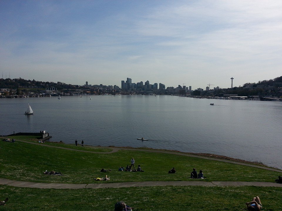
Record Wet March in Seattle, WA
Despite the very nice picture below from my good friend Aaron Theis out of Seattle, WA last Monday, March 24th, Seattle has seen it's wettest March in recorded history!
Take a look at some of the stats below from the National Weather Service out of Seattle, WA
(Image below courtesy: Aaron Theis)
Thanks for checking in and have a great week ahead! Don't forget to follow me on Twitter @TNelsonWNTV

No comments:
Post a Comment