By Todd Nelson
Well this is more like it! Finally, weather maps are looking a little more like the end of March and we've waited a long time for this. In fact, the last time we had a high temperature in the 50s on a weekend was Saturday, November 16th when we hit 50F! There's even a chance that we could hit 60F and the last time we achieved that benchmark on a weekend day was Sunday, October 13th when we hit 61F!
What ever you do Sunday, try to take advantage of the fleeting Spring-like weather. It's a must! Hey, you might even see your neighbors today for the first time since the snow started flying. Keep in mind that we just ended our 10th longest stretch of consecutive days with at least 1" of snow on the ground at the Minneapolis/St. Paul International Airport (113 days), which lasted from December 4th, 2013 to March 26th, 2014.
Some folks across the northern half of the state are set to pick up shovelable snow by Monday. Blizzard-like conditions may be possible across west-central Minnesota as a half of a foot or more could pile up along with near 40mph wind gusts.
March will go out like a lion this year and April looks to start off with a bang too, stay tuned!
===========================
SATURDAY NIGHT: Partly cloudy and quiet. Low: 33. Winds: SSE 5-10.
SUNDAY: Spring fever! Fading sunshine by the afternoon. High: 58. Winds: Turning NNE 10-15 late.
SUNDAY NIGHT: Becoming mostly cloudy with rain developing and possibly thunder across southern MN? Low: 40. Winds: NNE 10-15.
MONDAY: Breezy. Rain changes to slushy snow accumulations late.. Heavy snow across the northern half of the state. High: 48 early & falling. Winds: NNW 15-25.
MONDAY NIGHT: Windy. Snow likely (1" to 2" possible). Best chance of heavy snow accumulations across the northern half of the state. Low: 21. Winds: NNW 15-25.
TUESDAY: April Fools' Day. Clearing and cooler. High: 35.
WEDNESDAY: Clouds thicken with a chance of rain/snow. Wake-up: 22. High: 37.
THURSDAY: Lingering light snow chance early. Wake-up: 26. High: 39.
FRIDAY: Watching another storm south. Wake-up: 27. High: 41.
SATURDAY: Another nice Saturday? Bring it! Wake-up: 28. High: 48.
============================
This Day in Weather History
March 30th
1938: Springtime flooding hits Warroad and Grand Marais.
===========================
Sunrise/Sunset Times
March 30th
SUNRISE 657 AM
SUNSET 738 PM
===========================
Moon Phase for March 30th at Midnight
0.5 Days Since New Moon

==============================
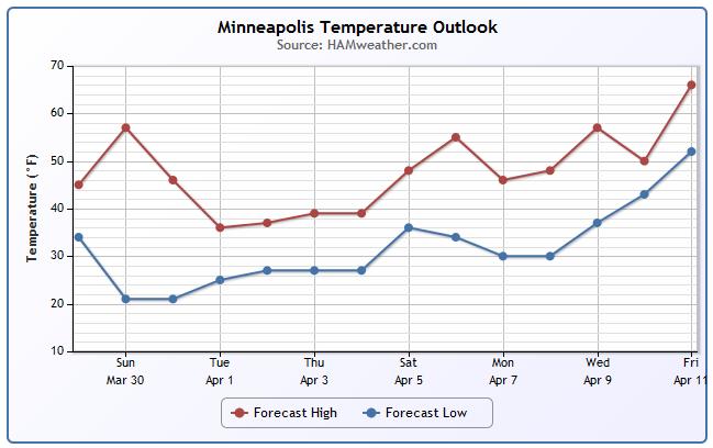
Minneapolis Temperature Trend
It appears that we'll strike gold on Sunday in the temperature department, but we take a bit of a tumble into the early part of next week as a storm system develops. The storm will be responsible for heavy snow across the northern part of the state by Monday.
Weather Outlook
Here's the latest from the National Weather Service out of the Twin Cities regarding our next storm system into early next week.
"A Blizzard Watch and Winter Storm Watch have been issued for parts of Minnesota for a strong system expected to impact the area on Monday into Tuesday. At this point, it appears that most of the precipitation will change over to snow for far western Minnesota through northern Minnesota. Very strong winds will accompany this system, hence the inclusion of the Blizzard Watch. Southeastern Minnesota and West Central Wisconsin will see mostly rainfall, but will see a mix and eventually some snow on the back side of the storm."
Here's more from the NWS Twin Cities
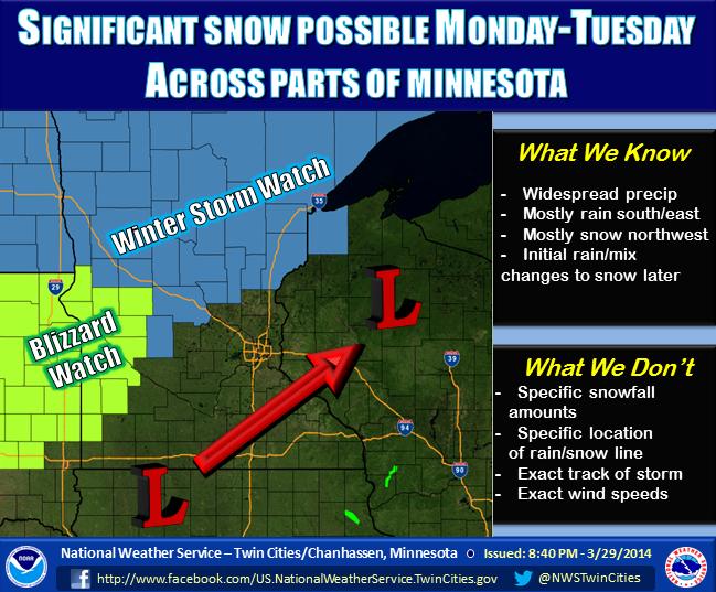
Winter Weather on the Way!
...MAJOR WINTER-LIKE EARLY SPRING SEASON STORM EXPECTED MONDAY AND MONDAY NIGHT...
A LOW PRESSURE SYSTEM WILL DEVELOP OVER THE CENTRAL PLAINS SUNDAY AND SHIFT EAST NORTHEAST THROUGH THE UPPER MISSISSIPPI RIVER VALLEY MONDAY AND MONDAY NIGHT. THIS STORM WILL BRING A VARIETY OF PRECIPITATION TYPES AS IT PROGRESSES...PRIMARILY RAIN CHANGING OVER TO SNOW EARLY MONDAY. THE HEAVIEST SNOW WILL OCCUR OVER WEST CENTRAL THROUGH NORTH CENTRAL MINNESOTA MONDAY...WHERE SNOWFALL AMOUNTS WILL LIKELY RANGE FROM 5 TO 8 INCHES...FALLING HEAVY AT TIMES. IN ADDITION...STRONG WINDS WILL DEVELOP AS THE CENTER OF THE STORM MOVES ACROSS...POTENTIALLY CREATING BLIZZARD CONDITIONS OVER FAR WESTERN MINNESOTA LATE MONDAY INTO MONDAY NIGHT.
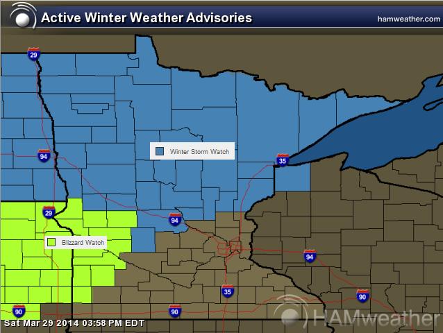
A WINTER STORM WATCH HAS BEEN ISSUED FOR PORTIONS OF NORTH CENTRAL MINNESOTA...INCLUDING THE ALEXANDRIA...SAINT CLOUD... WILLMAR...LITTLE FALLS AND MORA AREAS. A BLIZZARD WATCH HAS BEEN ISSUED FOR PORTIONS OF WESTERN MINNESOTA...INCLUDING THE MORRIS... BENSON AND MONTEVIDEO AREAS.
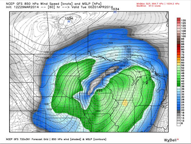
Storm Outlook
Here's a preview of what the winds aloft could look like surrounding the storm around 7pm Monday. It'll be a fairly tightly wound storm system so strong winds are expected to be blowing the snow around in places that see more significant amounts.
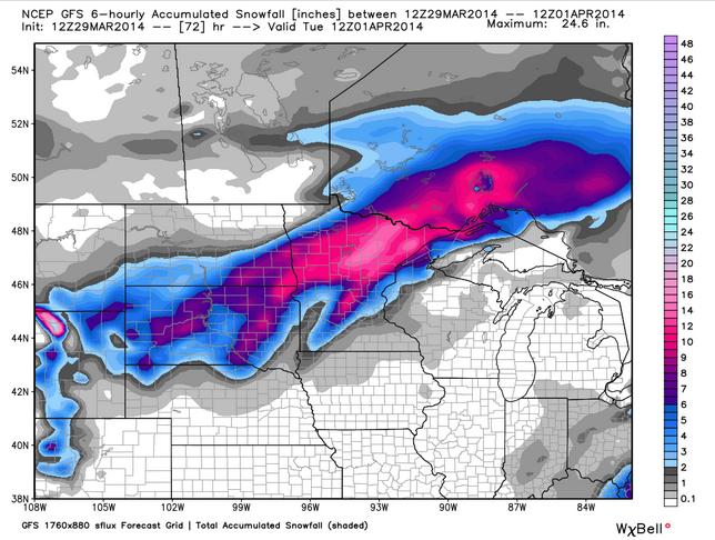
Snow Potential
The snow potential looks the greatest from the Dakotas to northern Minnesota with the most significant levels of snow across northern/northeastern Minnesota.
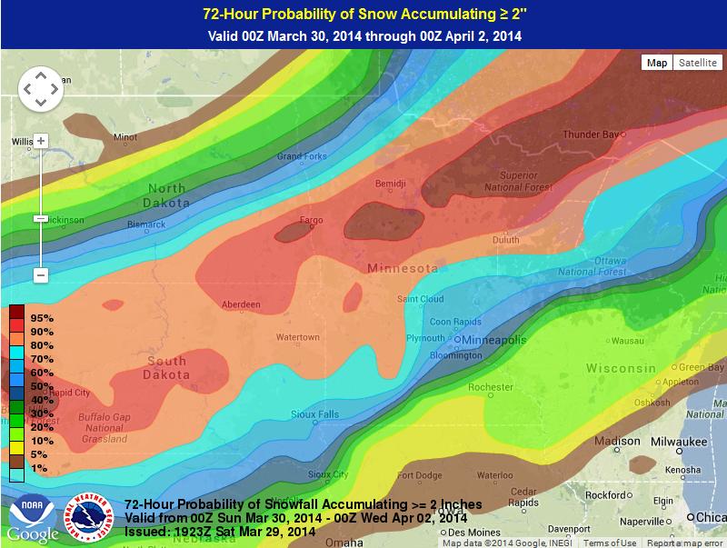
Probability of at Least 2" Snow or More
Here's the probability of at least 2" of snow by 7pm Tuesday, April 1st. Note that there is nearly a 100% chance of at least 2" snow across the northern half of the state.
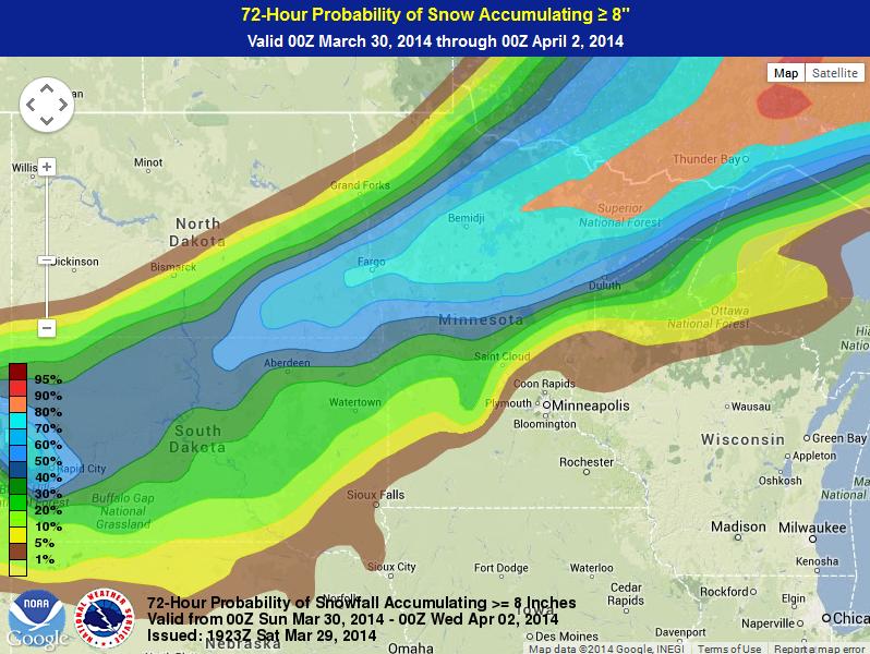
Probability of at Least 8" Snow or More
Even the probability of at least 8" of snow or more is pretty substantial across northern Minnesota.
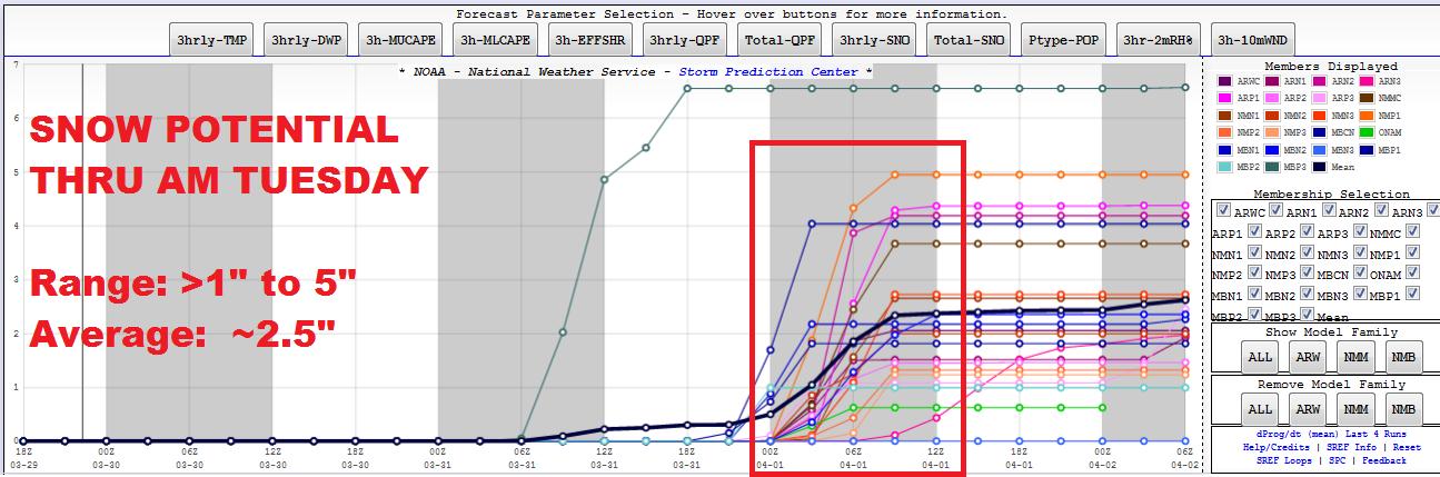
Minneapolis Snow Potential
Here's an interestingly look at the Minneapolis snow potential through early next week. According to National Weather Service SREF PLUMES, the snow potential through AM Tuesday suggests anywhere from less than 1" to as much as 5" (which I find a little aggressive at this point). The model average suggests around 2.5" of slop for the Twin Cities Metro. Stay tuned for more.
==================
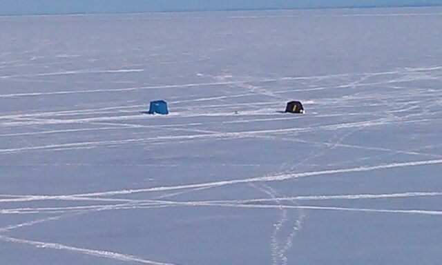
Lake Superior Ice Fishing
Now this seems a little strange to see ice anglers still at it on Lake Superior in Late March! In fact, I can't remember the last time I saw this! Thanks to my good friend Jeremy Frazier for the picture below from Duluth, MN who is enjoying a weekend with family!
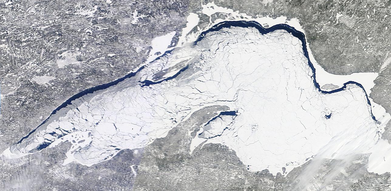
Lake Superior Ice Coverage
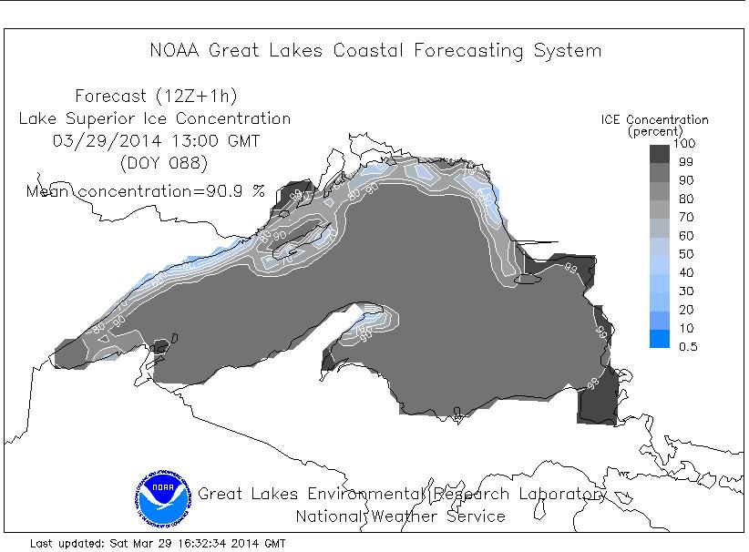
WOW! Here was impressive view of Lake Superior on a sunny Saturday, March 29th. Interestingly, the lake was still nearly 91% ice covered as of yesterday!
According to NOAA's GLERL, Lake Superior was officially 90.9% ice covered as of Saturday, March 29th
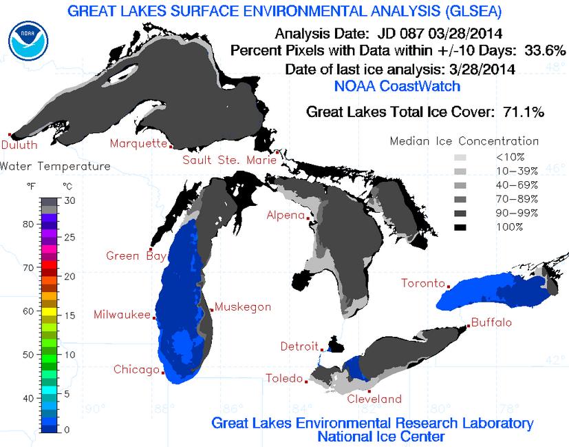
Great Lakes Ice Coverage
According to NOAA's GLERL, the Great Lakes ice coverage was down 71.1% as of March 28th, which is down from the 2013-2014 peak of 92.2% on March 6th (the most since 1979). The record Great Lakes ice coverage was 94.7% set in 1979.
Soggy Saturday in Florida
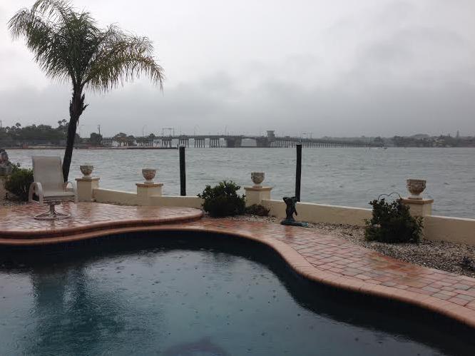
Thanks to my good friend Todd Frostad for the picture below out of Sarasota, FL where rain made for a somewhat soggy Saturday.
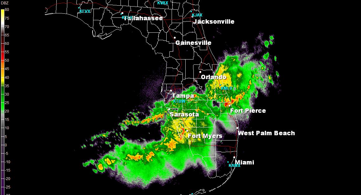
Stormy Saturday in Florida
This was the radar picture from around 4pm EDT Saturday. Quiet a few showers and storms rumbled across the state making for more of an indoor day. The good news is that weather conditions will improve into Sunday/early next week!
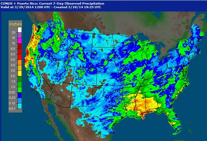
Precipitation Last 7 Days
Thanks to a more active jet stream, weather conditions across the country have been quite a bit more soggy. Take a look at how much precipitation we've seen from coast to coast in the last 7 days! Other than the Desert Southwest, just about every location has seen some type of precipitation since last weekend.
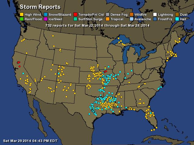
Storm Reports Past Week
Not only have we had quite a bit of moisture over the last week, but there has also a fairly significant uptick in the severe weather as of late. Note that we've had severe weather reports from coast to coast over the last 7 days!
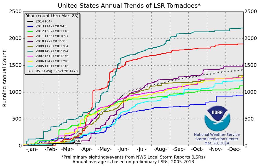
2014 Tornado Count
As of March 28th, the 2014 PRELIMINARY tornado count was only 64 across the nation. Interestingly, at this time last year, we had 147 tornado reports through this time, while in the year 2008, we had nearly 500 tornado reports through this time! The average (2005-2013) through now is 232, so needless to say, we are well behind where we typically are by this time of the year.
Active Weather Continues
The active weather pattern looks to continue across the country into next week as another piece of energy from the Pacific traverses the Rockies and into the Midwest by Monday and Tuesday. This particular system will not only dump copious amount of moisture in the western part of the country, but it will also be responsible for another heavy snow chance from the High Plains to the international border across the Upper Midwest.
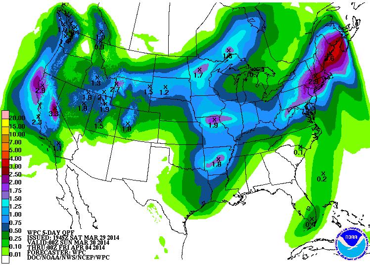
Precipitation Outlook Next 5 Days
The precipitation outlook over the next 5 days certainly looks from the West Coast to the central part of the country as our next storm system takes shape. Note that the higher elevations in the western part of the country look to pick up snow, while those from the Dakotas to the far northern reaches of the Upper Midwest will see some too.
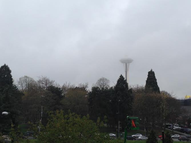
Wettest March on Record for Seattle, WA!
As of Friday, Seattle has seen 8.89" of precipitation for the month, which is officially the wettest March in recorded history! Thanks to my good friend Nicholas Shipes for sending this picture who snapped this earlier last week on one of their soggy days.
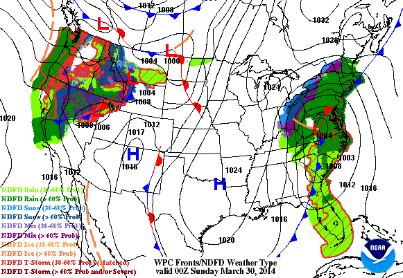
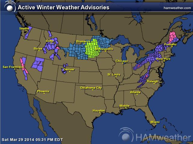
Winter Weather Ahead
Here are all of the winter weather headlines that have been posted across the nation. Note that not only are places in the higher elevations out west and the places in the Midwest under winter weather headlines, but lingering winter weather headlines are hanging on the Northeast through the end of the weekend.
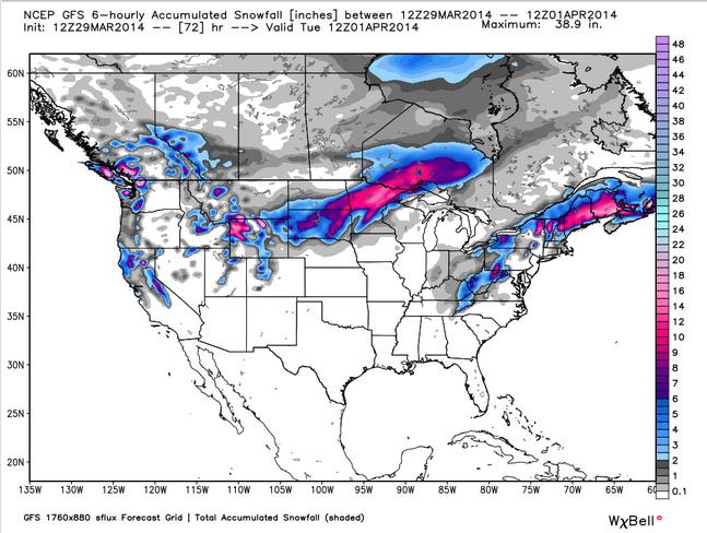
U.S. Snowfall Potential
Snowy swaths. Here's the snow potential through AM Tuesday across the nation. Note the snow blobs across the Midwest and the Northeast. Apparently winter is hanging...
Thanks for checking in and have a great rest of your weekend! Don't forget to follow me on Twitter @TNelsonWNTV

No comments:
Post a Comment