By Todd Nelson
March in Minnesota is never an 'out of the woods' kind of a month. For goodness sake, it's tourney time and we always seem to get something, don't we? Our current winter storm will be responsible for several inches of snow across parts of the state into Wisconsin. Interestingly, prior to today, we were running nearly 6" below average snowfall for the month of March in a month that typically sees nearly 11" in Minneapolis. In fact, according to NWS NOWData, March is actually the 3rd snowiest month during the winter season. Duluth typically sees a little more than 13" in the month of March, which is the 4th snowiest month during the season.
I'm hoping this particular winter event will be equivalent to pulling off a Band-Aid. Your commutes Tuesday and early Wednesday will be rough, but sun is just a couple of days from the Equinox, so it's intensity will help in the melting process over the next several days. The snow we have at this time of the year doesn't usually stick around too much longer.
By the way, average April snow in Minneapolis is only 2.8". The average high by April 1st is also 50F!
Yes, I'm selling hope.
Hang in there, it's almost over.
_____________________________________________________
MONDAY NIGHT: Light wintry mix begins to fill in across the state. Coating of sleet/snow possible by morning. Low: 25. Winds: ESE 5-15.
TUESDAY:
Wintry mix possible early, then changing to all snow later. Best chance
for accumulating snow in central and northeastern MN Significant
accumulations possible through Northwest Wisconsin. Snow: 3" to 6". High: 34. Winds: ENE 10-15
TUESDAY NIGHT: Snow continues. Additional 1" to 2"
possible by AM Wednesday. Snowfall amounts quickly rise as you head
into western/central/northeastern Minnesota Low: 26. Winds: NNE 10-25.
WEDNESDAY:
Storm slides east. Breezy and cooler with lingering light snow showers
and flurries early. High: 35. Winds: WNW 15-30.
THURSDAY: Happy Spring! Less wind. Sun early, then fading late. Wake-up: 14. High: 37
FRIDAY: Clouds thicken, chance of rain/snow? Wake-up: 25. High: 37.
SATURDAY: Partly sunny, another brisk March day. Wake-up: 12. High: 23.
SUNDAY: More sun, still quite chilly. Wake-up: 3. High: 25.
MONDAY: Chance of snow. Wake-up: 10. High: 34.
________________________________________________
This Day in Weather History
March 18th
1968: The earliest tornado to hit Minnesota. No one was hurt when it hit Watonwan County.
________________________________________________
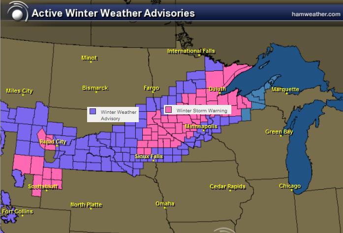
Winter Weather Headlines
The National Weather Service has issued several winter weather headlines from the Plains to the Great Lakes Region.
...LATE SEASON WINTER STORM TONIGHT THROUGH WEDNESDAY MORNING...
A
WINTER STORM WARNING IS IN EFFECT LATE TONIGHT THROUGH WEDNESDAY
MORNING ALONG AND WEST OF A LINE FROM REDWOOD FALLS TO HUTCHINSON...AND
CAMBRIDGE MINNESOTA. A WINTER WEATHER ADVISORY IS IN EFFECT FROM TUESDAY
AFTERNOON THROUGH WEDNESDAY MORNING EAST OF THE WINTER STORM WARNING
ALONG AND WEST OF A LINE FROM MANKATO...TO NEW RICHMOND WISCONSIN...TO
RICE LAKE WISCONSIN.
SNOW
WILL DEVELOP OVER CENTRAL MINNESOTA LATE TONIGHT AND SPREAD SOUTHWEST
ACROSS WESTERN MINNESOTA OVERNIGHT. SNOW WILL QUICKLY BECOME HEAVY AT
TIMES TUESDAY MORNING. THE SNOW WILL SLOWLY SPREAD EASTWARD THROUGH THE
DAY...REACHING SOUTHERN AND EASTERN MINNESOTA AND FAR WESTERN WISCONSIN
BY THE AFTERNOON. SNOW WILL DECREASE IN INTENSITY TUESDAY EVENING AND
TAPER OFF FROM WEST TO EAST EARLY WEDNESDAY MORNING. TOTAL SNOW
ACCUMULATIONS OF 6 TO 12 INCHES ARE EXPECTED ACROSS CENTRAL AND WESTERN
MINNESOTA... WITH 3 TO 6 INCHES POSSIBLE FROM SOUTH CENTRAL AND EAST
CENTRAL MINNESOTA TO NORTHWEST WISCONSIN. THE AXIS OF HEAVIEST SNOW WILL
LIKELY FALL ALONG A LINE FROM GRANITE FALLS TO LITTLE FALLS AND MORA.
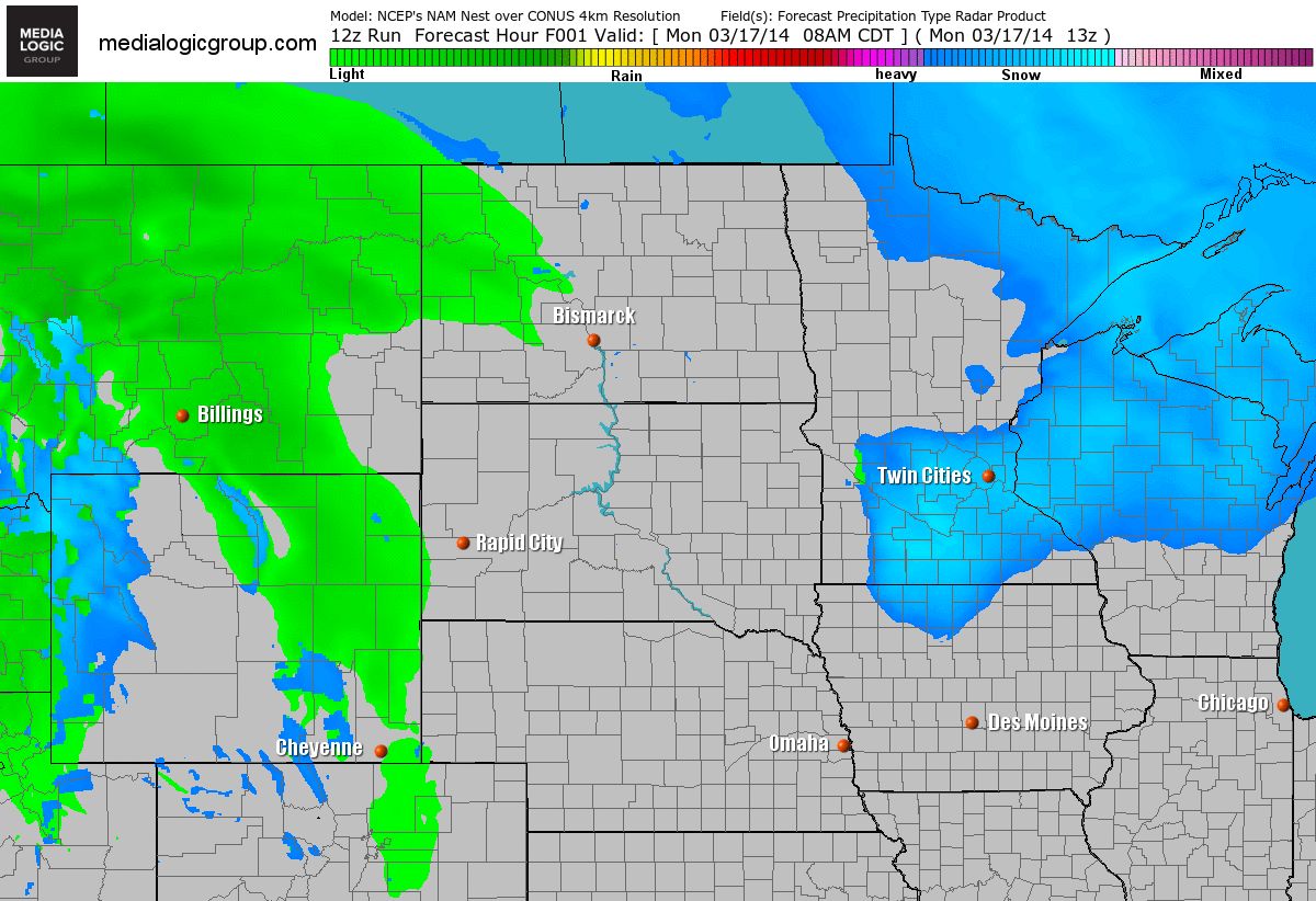
Future Radar
Here's
the messy storm setup through Wednesday evening. A mess of rain,
freezing rain, sleet and snow will all be possible across parts of the
Midwest.
Model Data
The
raw numbers from Monday for the Minneapolis area suggested snowfall
accumulations of 3.0" to as much as 9.0". The model average suggested
around 6" of sloppy snow through the event.

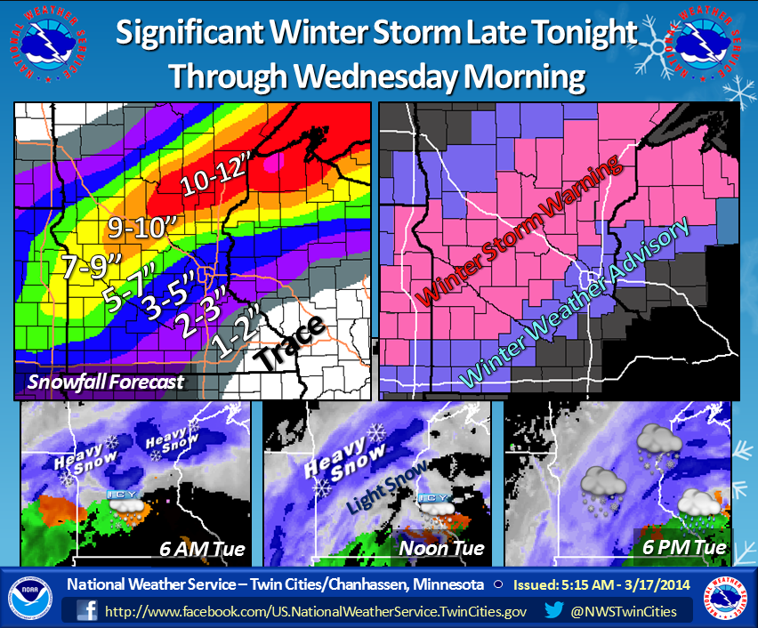
Snow Potential
This is what the National Weather Service out of the Twin Cities had to say about the snow potential for the Twin Cities CWA.
"A
strong winter storm will impact Minnesota and Wisconsin late tonight
through Wednesday morning. Updated to include adjusted snow totals.
Swath of heaviest snow hasn't changed much."
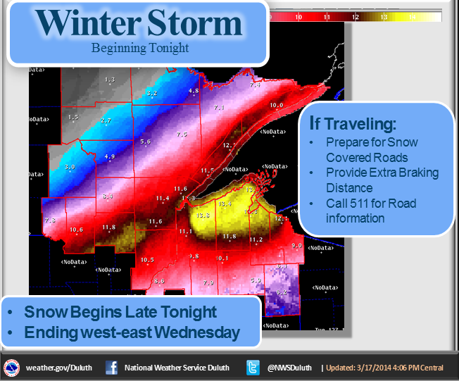
Duluth Snow Potential
This is what the National Weather Service out of Duluth posted on their Facebook page about the storm.
"A
winter storm is still on track to hit the Northland. Snow should
develop from south to north later tonight and especially during the day
Tuesday. Snow may take longer to develop over far northern Minnesota.
See image below for latest snow totals. Most of those values are on the
top of the expected snowfall range."
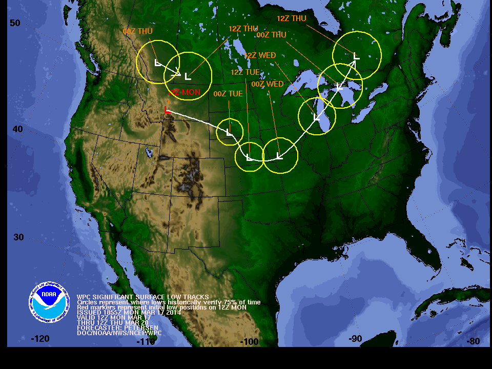
Storm Track
The
storm system that we're dealing with here takes a dip in the Midwest on
Tuesday before lifting back north into the Great Lakes Region. The best
snowfall potential will fall on the northern side of the low track.
Interestingly, the storm will draw up warmer air on it's eastern edge,
so precipitation will initially start as a wintry mix for some in the
Upper Mississippi Valley.
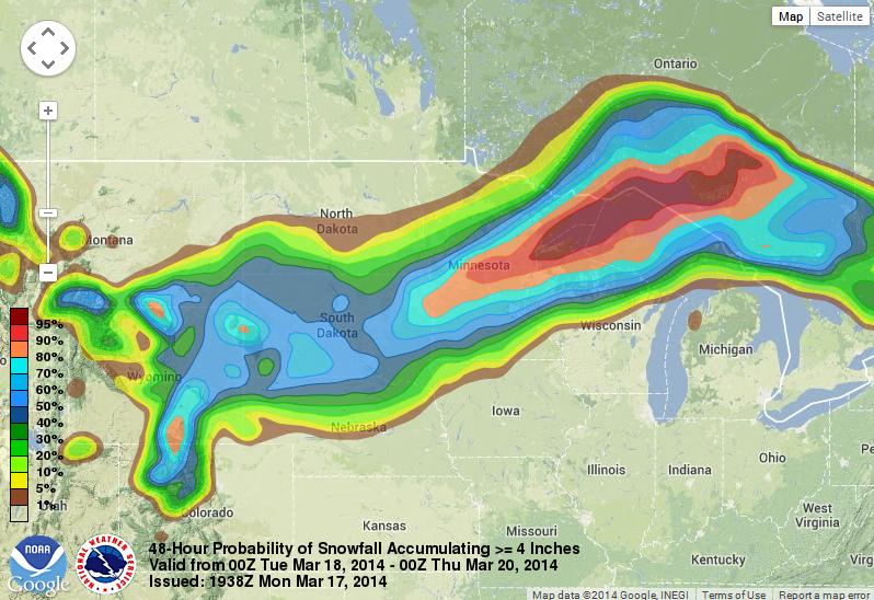
The
probability of at least 4" or snow or more snow a very good chance of
that occurrence from central Minnesota into the northeastern part of the
state to northern Wisconsin and the U.P. of Michigan.
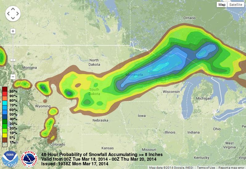
Probability of at least 8" of Snow
The
probability of at least 8" of snow or more still shows a fairly good
chance of that happening in the same swath listed above.
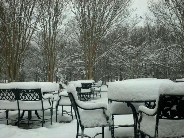
St. Patty's Day Snow
Thanks
to Mag Maroney-Bowen via WUSA9 out of Coles Point, VA for this very
festive image below. It was a very snowy start to a St. Patrick's
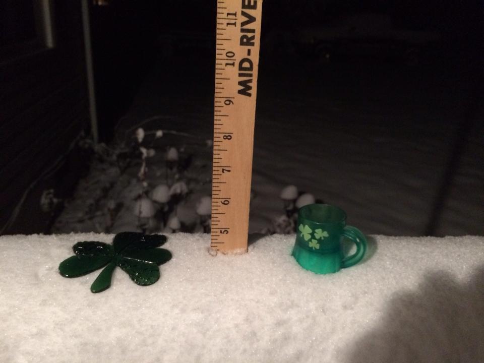
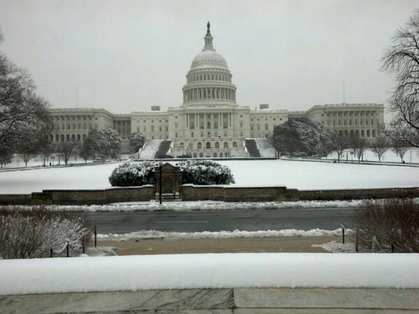
More D.C. Snow
Thanks
to my good friend Aaron Mertig for the picture below out of Washington
D.C. where another fresh blanket of snow came down early Monday morning.
There was enough snow to close federal offices and public offices
around D.C.. They even closed the Zoo!
Snowfall Analysis
Here's
the snowfall analysis from Sunday & Monday, which shows some of the
most significant tallies across parts of WV, VA and MD. The largest
tally I could fine was 13.7" out of Haywood, VA.
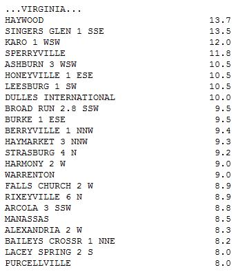
Here's a BIG list of all the snow tallies from this system from NOAA's WPC:
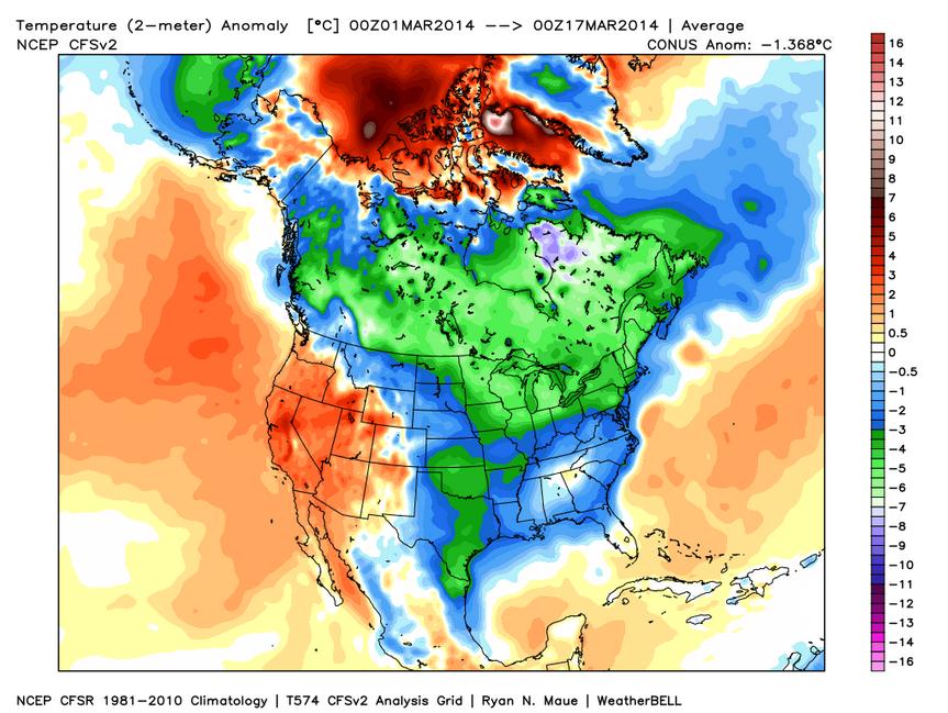
March Temperature Anomaly
So
far this March has been running quite a bit below average for the
eastern two-thirds of the nation. This map doesn't look much different
from the temperature anomaly for meteorological winter
(December-February).
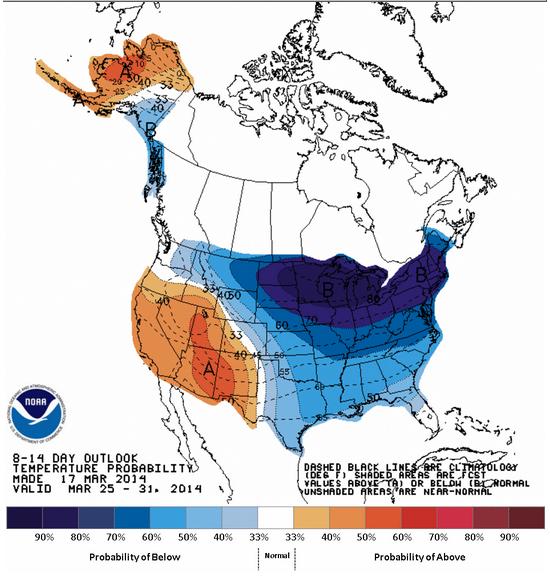
Temperature Outlook
According
to NOAA's Climate Prediction Center, the temperature outlook through
the end of March looks to stay colder than average for the eastern
two-thirds of the nation.
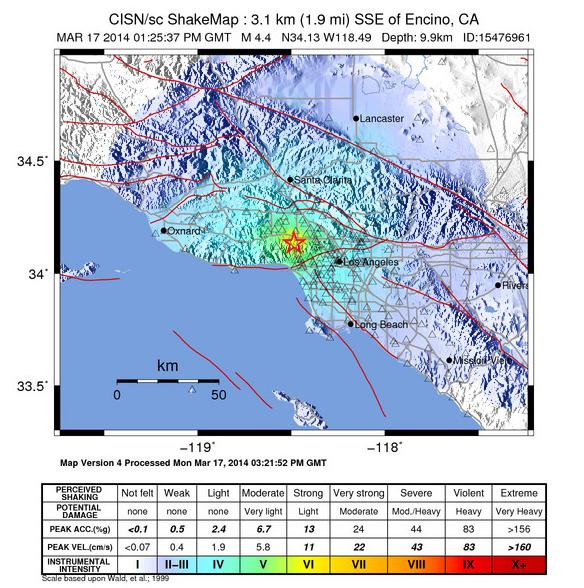
St. Patty's Day Earthquake
Did
you hear about the earthquake near Los Angeles, CA on Monday morning?
the 4.4 magnitude earthquake didn't do much other than gives folks a
quick jolt. It happened early in the morning and was even caught live
during a morning news program! Check out this video from KTLA HERE:

Shake Map
Here's
the shake map from USGS, which shows where the earthquake was felt.
Note that there are a light of light blue colors, which inidicates quite
a bit of light/moderate shaking.
ThunderShirt
Now
this is interesting and the first time I even heard of something like
this. Is your pet afraid of thunderstorms? This products claims to help
your furry friend relax during storms... it's the ThunderShirt!

Thanks for checking in and have a great rest of your week! Don't forget to check me out on Twitter @TNelsonWNTV

No comments:
Post a Comment