19 F. high in the Twin Cities Tuesday.
35 F. average high on March 4.
29 F. high on March 4, 2013.
19" snow on the ground.
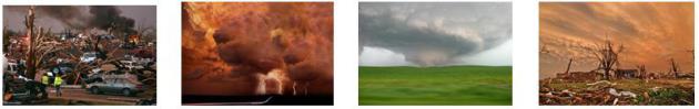
Polar Shrinkage
The
view out my window looks like the opening credits in the movie "Fargo".
I have a pet glacier in my back yard. When I tell my dog (Leo) to go
outside and do his business I swear he shakes his head no. "You kidding
me?"
It's so cold I can barely stand the four minutes I'm outdoors every day.
But
hope springs eternal. Today the sun is as high in the sky as it was on
October 6. Daylight is almost 2 hours and 40 minutes longer than it was
on December 21. Daylight saving time kicks off early Sunday morning!
Warm air can't push cold air out of the way. The Polar Vortex has to
retreat on its own, a process that will happen slowly, incrementally,
during March.
Breaking news: not one subzero low in sight. That's
progress. Last night's clipper may slow down your morning commute, but I
expect good travel weather into Monday, as winds aloft swing to the
west, allowing a precious puff of Pacific air to waft into Minnesota. A
thaw is likely Friday, again early next week. ECMWF guidance hints at
highs near 40F Sunday and Monday. We'll see more relapses of cold air
this month (count on it), but probably nothing polar.
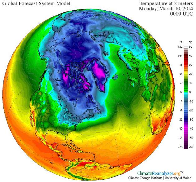
NOAA's CFS 45 day trend shows 60s the second week of April closer to the Twin Cities. What can possibly go wrong?
Trust me, I'm a weatherman.
* image above courtesy of Climate Reanalyzer at the University of Maine.
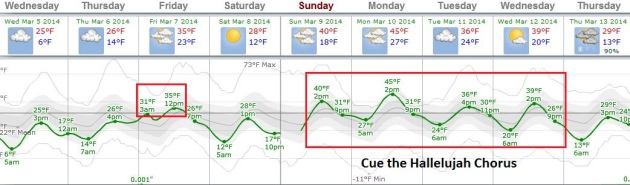
Slow Thaw.
The latest (12z) ECMWF guidance is trending warmer than previous runs
for next week; highs may top 40 Sunday, Monday and Wednesday. It may
actually feel like March out there - no major storms brewing just yet.
Graphic: Weatherspark.
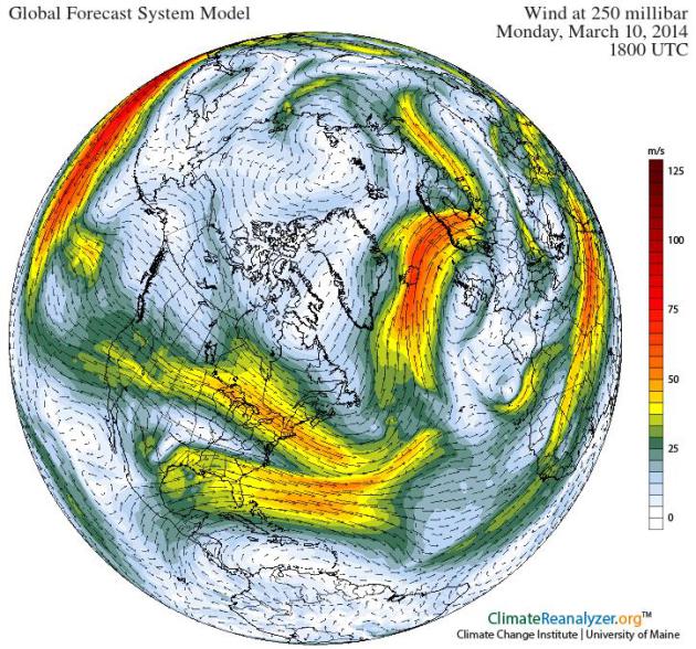
Long Overdue Shift In The Jet Stream.
Winds at 250 mb, where the core of the jet stream blows, become more
zonal, west to east, early next week, pushing milder, Pacific air across
the USA, a blessed hint of spring to come. Map: Climate Reanalyzer.
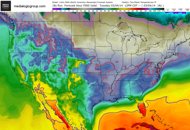
Cheering For The Solid Red Line.
Because that red line is the 32F isotherm, pushing into Minnesota by
Friday. The February-like airmass gripping much of America east of the
Rockies will slowly relax its stranghold in the coming days. 2-meter NAM
temperatures courtesy of NOAA and Ham Weather.
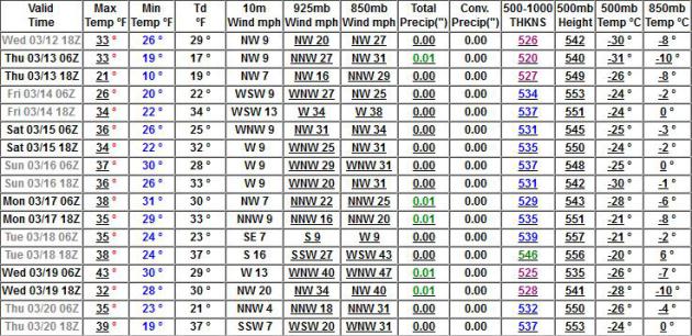
Feeling Better About March.
GFS data from NOAA shows more 30s and a few 40s into the third week of
March - no subzero relapses in sight, although I wouldn't rule out at
least one more night of negative numbers. No cause for noisy celebration
(yet), but at least we can all exhale. No more cringe-worthy cold
fronts are looming on the horizon.
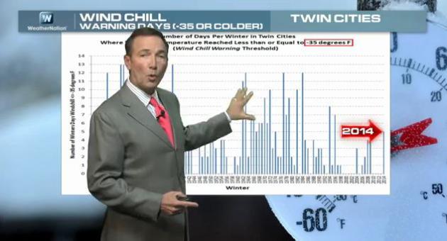
In Search Of Perspective.
We all know it's been a tough winter for much of the USA, but does it
really compare with the (savage) winters of the 70s and early 80s? One
measure is the number of winter days with a windchill below -35F,
dangerous enough for NOAA to issue Windchill Warnings. We had 5 of those
this winter. In the 70s and 80s we had a few winters with as many as
10-12 days of Windchill Warnings. 9th coldest meteorological winter for
MSP; 50 subzero nights, but no record lows, very few thaws to speak of
for 3 straight months. There are other measures, of course: ice on the
Great Lakes, the amount of snow that falls, and from Chicago to Detroit
locals may be even more sick of winter than we are in Minnesota. That's
the subject of today's
Climate Matters: "
WeatherNation
Chief Meteorologist Paul Douglas goes over some of the record breaking
cold and snow stats from the previous 3 months, which are statistically
the coldest months of the year. All time record lows broken... in March?
Par for the course the way this winter has been. But in the grand
scheme of things, we have seen worse. And folks out west are wondering
what all the fuss is about as Alaska saw its 15th warmest winter and Las
Vegas saw its warmest winter ever!"
Ask Paul. Weather-related questions, comments (and threats):
"
Paul
- since I live in the "feels like" weather (and not the actual air
temp), I am wondering how many days has the "feels like temp" been below
zero? Or maybe easier for you to count, the number of 24 hour periods
when the "feels like temp" has been zero? Real temps do not count except
for the record books."
- Angela Newfield
Angela - your
point is a good one, but NOAA and the local Climate Office don't track
the number of subzero windchill days during a given winter. What they do
keep tabs on are the coldest wind chills for each winter dating back to
1906, and the number of Windchill Advisories (-25 WC or colder) and
Windchill Warnings (-35 WC or colder) issued from winter to winter. Pete
Boulay at the Minnesota Climatology Working Group passed along a
link which made me do a double-take. His comment: "
Bottom line is that there have been worse winters!" Indeed.
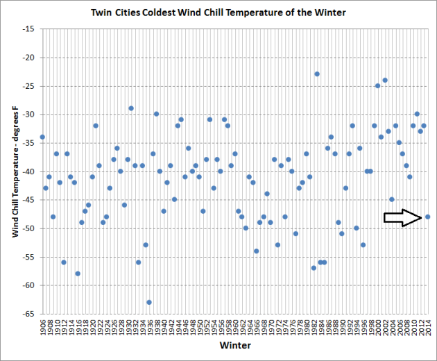
Coldest Windchill Temperature Of The Winter.
It's true the windchill formula was revised around 2001, but the trend
in recent winters is for fewer (severe) wind chill readings from winter
to winter. Our coldest wind chill at MSP to date this winter: -48F. The
60s, 70s and 80s saw wind chills dipping into the -50 to -57F range, as
cold as -63F during the winter of 1936. Graphic: Minnesota Climatology
Working Group.
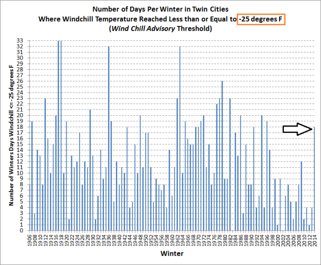
Number of Windchill Advisories Issued Each Winter at MSP.
So far it looks like 18 days with Windchill Advisories this winter in
the Twin Cities. From the 60s thru the 80s we tended to see more
advisories for a windchill of -25F or colder.
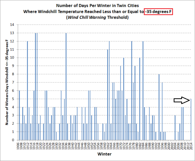
Winter Days With Windchill Warnings In The Twin Cities.
So far this winter we've enjoyed/endured 5 days with Windchill
Warnings, issued by NOAA when the chill factor is expected to dip to
-35F or lower. We saw far more dangerously cold days (combination of
temperature and wind) in the 60s, 70s and early 80s. Not to minimize the
pain this winter, but Pete is right - we have seen worse.
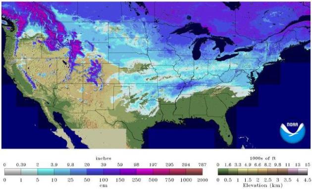
Silent Spring.
Old Man Winter is hanging on for dear life, you can see his snowy
scratch-marks as far south as Texas and Arkansas, where snow on the
ground in early March is rare, but not unprecedented. As of yesterday
NOAA reports snow on the ground over 53.9% of the lower 48 states. That's down from 61.2% of the USA on February 4.
Why Snowstorms Are More Devastating Now To American Cities.
An inch of snow in the 60s? No big deal. Our parents called this
"flurries". Today an inch of snow falling at the wrong time and wrong
temperature can bring a city's transporation grid to a halt. What has
changed? Here's an excerpt of an interesting story at
NBC Philadelphia: "
Snowstorms
have become devastating to American cities -- thanks to a commonplace
technology: the private automobile. "The evil snow is upon us.” So wrote
New York lawyer and diarist George Templeton Strong in December 1879,
describing a storm that had paralyzed the city. Teams of horses pulled
ploughs through the snow, piled high along the sidewalks; downed
electrical lines pitched the streets into darkness. In the future,
Strong imagined, things would be better. “A century hence cities will be
put under glass,” he predicted, “and New York will be enclosed in a
huge crystal palace...”
Photo credit above: "
Slippery West Sedgwick Street in Northwest Philadelphia afer a recent storm." Bas Slabbers - NewsWorks.org.
Ice-Covered Lakes May Be Bottling Arctic Cold For Spring.
Chicago has had a very memorable winter: 3rd coldest meteorological
winter with 74" snow, more than 43" above average, to date. They've
experienced 2 winters in the Windy City! Here's a recent video and
excerpt from
The Chicago Tribune: "
With
March just days away, Chicagoans can’t be blamed for looking forward to
the disappearance of the polar vortex. But be warned: with the Great
Lakes more ice-covered than they have been in decades, the latest blast
of arctic chill is being bottled for spring. The early descent of this
season’s chill forced the Coast Guard to start its ice-breaking ships
sooner than any time in recent memory and raises the prospect that all
that frozen water will slow any hint of a spring warmup..."
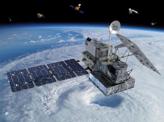
A World Of Water, Seen From Space. Here's
an excerpt of a good description of the latest NASA satellite to be
launched into low orbit to study Earth's water supply, courtesy of The
Atlantic and
Yahoo Finance: "...
NASA
calls this latest satellite the Global Precipitation Measurement Core
Observatory. I propose we call it, to make things simpler for ourselves,
"Core." Core is, technically, a weather satellite, built to observe the
workings of the Earth from beyond its bounds. But it's more complex
than a traditional satellite: Core gets its name from the fact that it
is the central unit in a network of nine satellites studded across the
exterior perimeter of the Earth, contributed to the cause by various
countries and space agenices. Their job? To analyze the planet's water,
from beyond the planet..."
Image credit above: "
The GPM Core satellite launches from Japan on Thursday, February 27." (NASA).
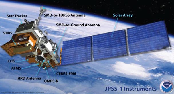
Storm-Tracking NOAA Satellite System Gets A Technology Boost.
CNET
describes how these new Earth platforms may improve storm predictions
by providing higher-resolution data streams into the models we use on a
daily basis; here's a clip: "
A three-satellite storm-tracking system
run by the U.S. government is getting some updates that will support a
complete technological refresh. Raytheon said today that it has booked
$185 million in new business for the Joint Polar Satellite System's
Common Ground System. The JPSS, a collaborative system between the
National Oceanic and Atmospheric Administration and NASA, is a
polar-orbiting environmental system designed to both track storms and
other weather events and take and send back to Earth imagery showing
changes in the planet's environment over time..."
Image credit above: "
One of the three Joint Polar Satellite Systems satellites.
" (Credit: NOAA/NASA).
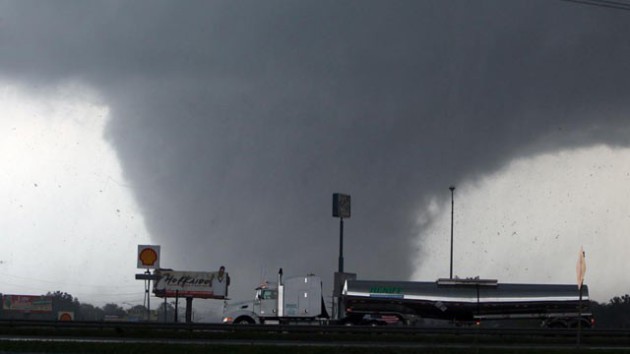
New Hurricane Model Can More Accurately Predict Hurricane Path, Intensity. redOrbit has an interesting story - here's the introduction: "...
In
addition to incorporating real-time Doppler radar information, the
convection-permitting hurricane analysis and forecasting system
(WRF-EnKF) also uses high-resolution cloud-permitting grids, which allow
for the consideration of individual clouds in modeling a storm system.
"Our model predicted storm paths with 100 km - 50 mile - accuracy four
to five days ahead of landfall for Hurricane Sandy," Zhang said. "We
also had accurate predictions of Sandy's intensity..."
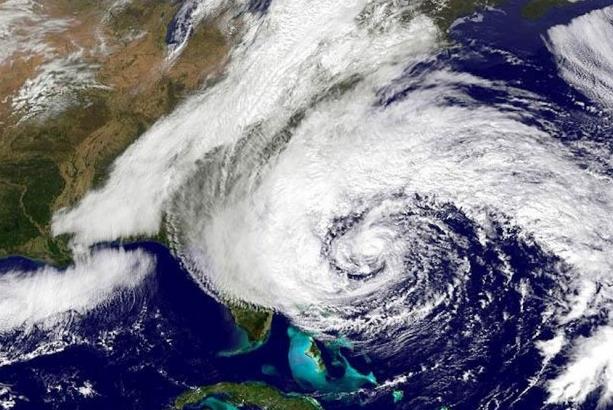
Image credit above: "
Superstorm Sandy as it slams the Northeast in October 2012." Credit: NOAA/NASA.
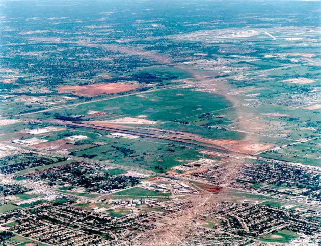
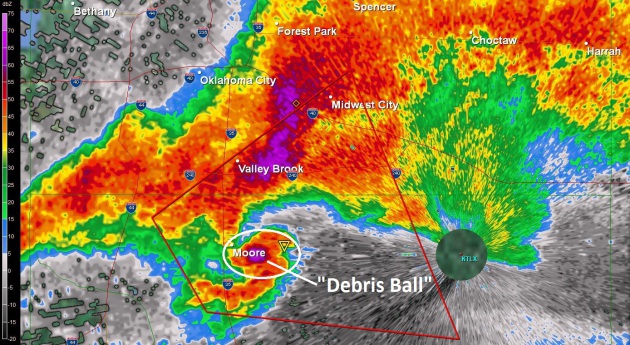
Oklahoma Congressman's Proposal Would Extend Lead Time For Tornado Warnings.
A 45-60 minute lead time for tornadoes? It's not as far-fetched as it
sounds. But it brings up an interesting dilemma: can you provide too
warning? If I have an hour's notice I might be tempted to run home, or
pick up the kids at school - instead of heading to the basement. Here's
an excerpt from
Insurance Journal: "
An
Oklahoma congressman has proposed legislation that would make the
protection of people and property a priority for federal weather
forecasters and extend the lead time for tornado warnings. Oklahoma
Insurance Commissioner John D. Doak has expressed his support for the
Weather Forecasting Improvement Act (H.R. 2413), sponsored by
Congressman Jim Bridenstine (R-Oklahoma), which would establish the
Tornado Warning Extension Program. The resolution is aimed at funding a
research program within the National Oceanic and Atmospheric
Administration (NOAA) to extend the lead time for tornado warnings
beyond one hour..."
When
Hurricane Sandy slammed into southern New Jersey in October 2012, it had essentially confounded both the
NOAA‘s Global Forecast System (GFS) and the European Centre for Medium-Range Weather Forecasts (ECMWF).
Now,
a new real-time hurricane analysis system being developed at Penn State
University has been shown to accurately predict the track and intensity
of the deadly storm.
“For this particular study aircraft-based
Doppler radar information was ingested into the system,” said
Fuqing Zhang,
a professor of meteorology at Penn State. “Our predictions were
comparable to or better than those made by operational global models.”
Read more at http://www.redorbit.com/news/science/1113081033/hurricane-model-accurately-predict-storm-path-intensity-022614/#ezvDvxMucTOvdtR6.99Oklahoma Congressman's Proposal Would Extend Lead Time For Tornado Warnings.
A 45-60 minute lead time for tornadoes? It's not as far-fetched as it
sounds. But it brings up an interesting dilemma: can you provide too
warning? If I have an hour's notice I might be tempted to run home, or
pick up the kids at school - instead of heading to the basement. Here's
an excerpt from
Insurance Journal: "
An
Oklahoma congressman has proposed legislation that would make the
protection of people and property a priority for federal weather
forecasters and extend the lead time for tornado warnings. Oklahoma
Insurance Commissioner John D. Doak has expressed his support for the
Weather Forecasting Improvement Act (H.R. 2413), sponsored by
Congressman Jim Bridenstine (R-Oklahoma), which would establish the
Tornado Warning Extension Program. The resolution is aimed at funding a
research program within the National Oceanic and Atmospheric
Administration (NOAA) to extend the lead time for tornado warnings
beyond one hour..."
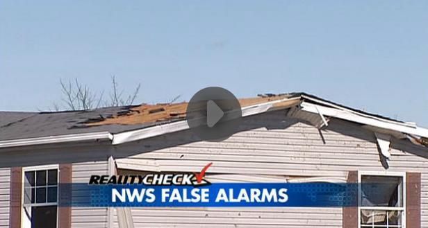
Reality Check: The Tornado "False Alarm" Problem.
The last I checked 70% of tornado warnings were false alarms,
nationwide. It's always better to err on the side of safety, caution and
protecting human life, but too many false alarms and the public can be
apathetic. "They're crying wolf again - just ignore the sirens". Here's a
video clip and excerpt from a story at
fox19.com: "
It
has been a crazy winter, filled with snow and bitter cold. Mother
nature trumped the winter weather on Thursday with the first severe
weather episode of 2014. The National Weather Service issued five
tornado alerts. Only three weak funnels appeared -three out of five with
a false alarm rate of 40 percent. Why does the Tornado Warning policy
treat weak, spin-up funnels the same as it does monstrous killer
tornadoes? The policy is set at high levels in the National Weather
Service bureaucracy. The system needs to be fixed..."
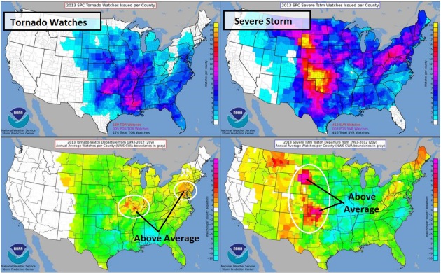
Tornado And Severe Storm Watches Issued In 2013.
Last year was relatively quiet, especially for tornadoes, with a few
notable exceptions (around Oklahoma City). The upper left graphic shows
the total number of tornado watches, the lower left depicts departure
from the 20 year averages - showing a slight increase in tornado watches
over the Middle Mississippi Valley and Mid Atlantic. The column on the
right shows total number of severe storm watches (upper left), and
departure from average, with a more significant spike in severe storm
watches for the Plains. Source:
NOAA SPC.
Researcher Finds Possible Clue To Some Tornadoes' Paths. The Wichita Eagle has the story; here's an excerpt at
kansas.com: "
Tornado
Alley weather officials say they’ll be watching supercell thunderstorms
closely this year for a potential clue indicating a potential tornado’s
path. That clue lies in the speed of winds at the middle levels of the
atmosphere. If some preliminary data is confirmed by additional
research, meteorologists may be able to more readily convince people
near but not in a tornado’s expected path to take shelter..."
The Future Of Severe Weather Forecasting. Here's a video and excerpt from News 9 Chief Meteorologist David Payne in Oklahoma City on
NewsOn6.com: "...
He
said he's never seen so many intense tornadoes in such a short period
of time as we saw in May 2013. He adds we took something good from the
outbreak, new data models that will help us better predict future
storms. "These are models that can actually model individual storms and
they're going to come up with an ensemble of forecasts of varying
initial conditions," Bluestein said. "You may be able to assign, a
better probability that yes, the next day there will be storms. Of those
storms, there will be a certain chain that there will be tornadoes..."
The Impact Of Disregarding Weather Related Risk. Here's an excerpt of an article at
seekingalpha.com that caught my eye: "...
Recent
events have emphasized the need for an all-encompassing, easily
implementable risk management plan, especially with respect to weather related risk.
Though often overlooked by many companies and governing leaders,
weather related crises are a primary risk to many organizations, as
these incidents have the potential to significantly and unexpectedly
impact operations, supply chains, and customer demands..."
Your Joints, Pain And The Weather.
All those things your grandmother taught you are true. Our bodies are
(mostly) water - why wouldn't we respond to pain sparked by continuous
fluctuations in atmospheric pressure, temperature and moisture? Here's a
clip from an article at
Grandparents.com. What, you don't troll this site? "...
Several medical studies—although not all—back up these suspicions. As early as the 1960s, a University of Pennsylvania physician put
people with arthritis into a weather chamber and found that falling
barometric pressure and increased humidity increased the perception of
pain. In 2007, Tufts researchers studied 200 people with knee arthritis and found that both barometric pressure and cold affected pain. In January of 2014, Dutch researchers
found that in people with severe hip arthritis, barometric pressure and
humidity had a modest effect on pain perception. (Weather can have
other painful effects, too: There’s evidence that lightning can trigger migraine headaches, for example.)..."
Read more here: http://www.kansas.com/2014/03/03/3321809/researcher-finds-possible-clue.html#storylink=cpy
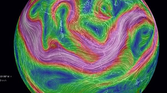
Play With Earth's Beautiful Weather Systems In Your Browser.
They look beautiful, almost poetic from 22,300 miles above the ground.
Here at ground level? Not so much. Here's a clip from a story at
geek.com: "
With
a program called Natural Earth, programmer Cameron Beccario has created
a beautiful, real-time model of Earth’s wind and ocean dynamics. Though
it’s fed with some of the most accurate and up-to-date information we
have, most people probably won’t be using it as an educational or
scientific tool; rather, they will marvel at its aesthetic beauty, and
fiddle with the included controls to see various aspects of the weather over their home country. Check out the map and be sure to click on the ‘Earth’ logo at the bottom left for access to the surprisingly robust rendering controls..."
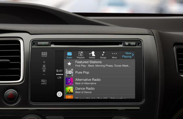
Apple's New CarPlay System Will Turn Tens Of Millions Of Cars Into iPhone Accessories.
TechCrunch
has a good overview of how (soon) you may be able to tap into apps and
music and safely (?) respond to texts in your favorite vehicle; here's
the intro: "
Apple’s newly announced CarPlay, which is the rebranded version of iOS in the Car,
a system for converting your vehicle’s in-car entertainment system into
an iOS-powered dashboard fed content and brains by your phone, is a
play that could massively expand the Apple mobile ecosystem – by turning
cars into app-enabled iPhone accessories. The CarPlay system was
revealed today during the Geneva Motor Show, where partners Ferrari, Mercedes-Benz and Volvo all announced that they’d begin shipping CarPlay-enabled vehicles to drivers this week..."
TODAY: Icy start. Clouds linger. Winds: East 10. High: 25
WEDNESDAY NIGHT: Partly cloudy. Low: 12
THURSDAY: Breezy and milder with peeks of sun. High: 30
FRIDAY: More clouds than sun. Tolerable. Wake-up: 26. High: 34
SATURDAY: Partly sunny, slightly cooler. Wake-up: 13. High: 28
SUNDAY: Some sun. Grilling weather. Wake-up: 15. High: 40
MONDAY: Slushy mess, but who cares? Wake-up: 28. High: 44
TUESDAY: Cooler with intervals of sun. Wake-up: 24. High: 36
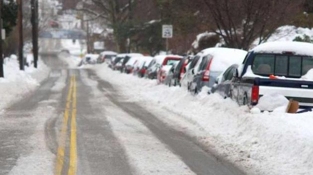
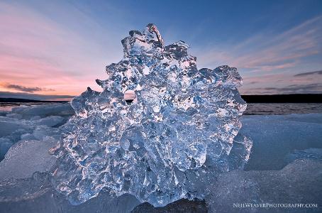
* Photo above courtesy of Neil Weaver at
neilweaverphotography.com.
Climate Stories....
Energy CEO: Climate Change Is Real, Driven By Humans. I almost fell off the Doppler after reading this story at
fuelfix.com; here's an excerpt: "
BHP
Billiton CEO Andrew Mackenzie, who leads the world’s largest mining
company, said Tuesday that climate change is real and driven by human
activity. Speaking to energy industry leaders at the CERAWeek conference
in Houston, Mackenzie, a geologist by training, said evidence of the
climate trend is clear and compelling. “You can’t argue with a rock,”
Mackenzie said, noting geological signs of the change. Mackenzie — whose
Australia-based company produces oil, gas, coal and uranium — also
advocated for the creation of a carbon pricing system that would enable
the market “to identify the most cost-effective methods of cutting
emissions...”
Photo credit above: "
BHP Billiton CEO Andrew Mackenzie speaks at the IHS CERAWeek energy conference in Houston on March 4, 2014." (Mayra Beltran/Houston Chronicle).
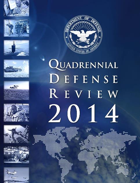
The Defense Department Takes Climate Change Seriously.
The Navy is concerned about projecting power in a rapidly melting
Arctic, and implications of higher sea levels on their major ports of
Norfolk and San Diego. The 88 page PDF of The Department of Defense
Quadrennial Defense Review 2014 is
here. Navy Admiral David Titley (retired) writes: "
For
all the defense policy geeks ... DoD released today the 2014
Quadrennial Defense Review -- climate change and its impacts to national
security highlighted throughout. About as good as it gets from a high
level policy document."
* more details on the implications of rising seas and increased climate volatility on the military at
The Center for Climate & Security.
Climate Study: Rising Seas Could Wipe Out Many Cultural Landmarks.
LiveScience has the story - here's a clip: "...
Sea-level
rise has been a key concern for climate scientists, but making precise
projections of how much, and how fast, sea levels may rise remains
tricky. As water heats up, it expands and takes up more space, which
causes sea levels to rise. Furthermore, rising surface temperatures
trigger melting ice, particularly in the sprawling ice sheets that cover Greenland
and Antarctica. It is difficult to make accurate predictions of how
much sea levels may rise, but Marzeion said it is generally thought that
for every 5.4 degrees F of warming, sea levels could rise nearly 23
feet (7 meters)..."
Global Warming Slows Down Antarctica's Coldest Currents.
Scientific American has the article - here's the introduction: "
A
shift from briny to fresh in Antarctica's ocean waters in recent
decades could explain the shutdown of the Southern Ocean's coldest,
deepest currents, a new study finds. The cold currents, called the
Antarctic Bottom Water, are chilly, salty rivers that flow from the
underwater edge of the Antarctic
continent north toward the equator, keeping to the bottom of the
seafloor. The currents carry oxygen, carbon and nutrients down to the
deepest parts of the ocean. Previous studies have found this deep, dense water is disappearing, though researchers aren't sure if the shrinkage is part of a long-term trend linked to global warming, or a natural cycle..."
Photo credit: "
Icebergs and sea ice floating atop near-freezing surface waters of the Weddell Sea." Courtesy of Eric Galbraith.
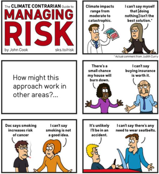
Cartoon: The Climate Contrarian Guide To Managing Risk.
Maybe if we ignore it - it'll go away? If we managed the rest of our
lives the way some want to "manage" climate change and increased weather
volatility, we'd be accused of taking leave of our senses. Here's an
excerpt from
The Guardian: "...
When it comes to managing risk, uncertainty is not our friend.
Uncertainty means it's possible the outcome will be better than we
expect, but it's also possible it will be much worse than we expect. In
fact, continuing with business-as-usual would only be a reasonable
option in the absolute best case scenario. Doing nothing is betting the
farm on a very low probability scenario. It's an incredibly high-risk
path that fails to reduce the threats posed by the worst case or even
most likely case scenarios..."
Cartoon credit above: "
The climate contrarian guide to managing risk." Created by John Cook.


Lloyd Security's is the tops! A local company that really has treated me and my family with the utmost respect, from the quick installation to the reasonable pricing, we really feel safer with Lloyd on our side. We're customers for life!
ReplyDeletewireless security