Winter Storm Watch in effect for the Twin Cities and much of central/southern Minnesota.
37 F. high in the Twin Cities Tuesday.
50 F. average high on April 1.
36 F. high on April 1, 2013.
.2" snow fell yesterday at KMSP.
63" snow so far this winter in the Twin Cities, 10.9" above average, to date.
49.3" snow had fallen last winter as of April 1.
How 'bout those Twins!
I'm
starting to wonder out loud if it's too late to find a sports gig in
town. Something a little less controversial than babbling about
Minnesota's increasingly manic weather.
Just when I thought I'd
seen everything along comes Monday's lion-like departure to March. 70s.
Tornadoes. Blizzards. On the same day - in the same state.
A state of severe atmospheric confusion.
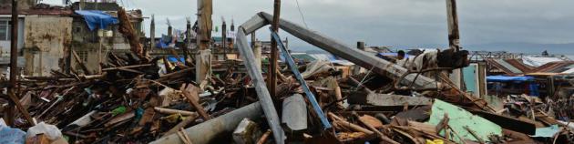
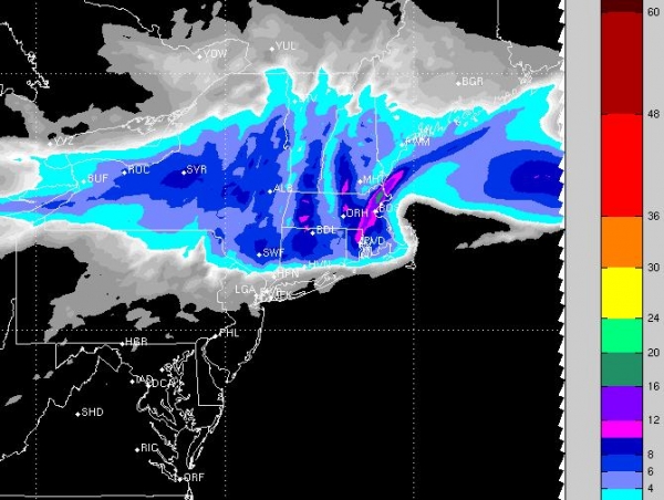
Folks up in Thief River Falls can be excused for being extra-cranky: 18 inches of new snow fell.
Dazed
robins in my yard are chirping a melancholy tune, because they must
sense what's coming. It's still too early to opine about snowfall
totals, but both ECMWF and GFS models suggest plowable, shovelable
amounts of snow here Thursday; wet, heavy, slushy, gloppy "heart attack"
snow. Freeways may stay wet and mushy, but Friday may wind up testing
your character, resolve and stoic sense of humor. A Winter Storm Watch
has been posted - details below.
Skies clear Saturday; long-range guidance showing a Pacific puff of 50-degree air the latter half of next week.
There's
a good chance El Nino will return by May, a warm stain of Pacific Ocean
water that usually results in warmer than average temperatures,
nationwide. We'll see.
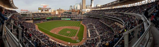
Expect 40s Opening Day at Target Field.
Alerts Broadcaster Briefing: Issued Tuesday night, April 1, 2014.
*
Slight severe risk Wednesday (especially PM hours) from near Kansas
City and Little Rock to Tulsa, Dallas and Shreveport - a few tornadoes
are likely, and I expect Tornado Watches to be issued by NOAA SPC by
early afternoon.
* Severe risk shifts east on Thursday, with a
potential for tornadic supercell T-storms from St. Louis and Little Rock
to Evansville, Bowling Green, Kentucky and Memphis, Tennessee. A few
large, violent tornadoes can't be ruled out, especially Middle
Mississippi River Valley Thursday afternoon and evening, with a squall
line containing hail and damaging straight line winds pushing into the
Ohio Valley by Thursday night.
* It sounds like a cruel April
Fool's joke, but the weather maps look more like early March than early
April across the Upper Midwest. Significant, plowable snows are possible
from northern Iowa and the southeastern half of Minnesota into much of
Wisconsin late Thursday into Friday. Significant travel delays are
expected from Des Moines, Rochester and the Twin Cities to Eau Claire,
La Crosse and Wausau, Wisconsin, with Friday being the worst travel day.
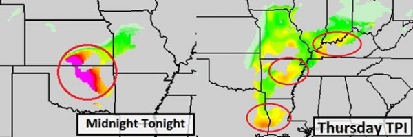
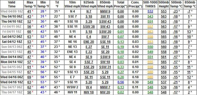
Tracking The Severe Storm Risk.
Our proprietary TPI (Tornado Potential Index) model shows a significant
risk of damaging winds and hail from near Tulsa and Oklahoma City to
Dallas and Shreveport Wednesday afternoon; the risk expanding north and
east on Thursday into the Middle Mississippi Valley, from Cairo,
Illinois to near Louisville, Bowling Green, Memphis and Nashville. Right
now this doesn't look like a devastating, widespread tornado outbreak,
but
as many as 5-10 EF1-EF3 tornadoes are possible; a few may
approach large urban areas with the greatest risk of isolated tornadoes
around the dinner hour, from 4 PM to 8 PM local time. Be alert for
Tornado Watches issued by early afternoon;
Tornado Warnings
will be issued for specific portions of counties by local National
Weather Service offices. If a large tornado approaches a major metro
area a
Tornado Emergency will be issued. The risk is small, but not zero. Graphics:
Ham Weather.
On the cold side of the storm winter is still very much alive and well:
Very Plowable.
Although early April snows are much different than January snowfalls
(they tend to be heavy and wet with higher moisture content) travel
impacts are likely Thursday into Friday across the Upper Midwest and
Upper Mississippi Valley, with the greatest amounts projected from near
Des Moines, Waterloo, La Crosse and Rochester to Eau Claire and the U.P.
of Michigan, where some 6-12" snowfall totals are possible by Friday
night.
Chicago should be spared any snowy headaches this time around - the Twin Cities may not be so lucky. Map:
Alerts Broadcaster.
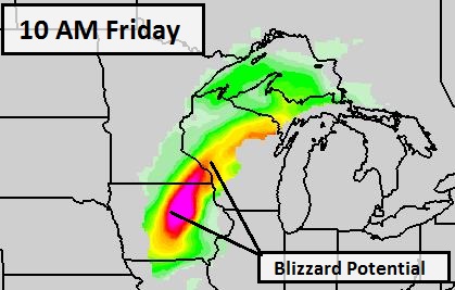
Blizzard Potential.
Our internal, proprietary BPI (Blizzard Potential Index) shows a high
probability of low visibility and strong, sustained winds over 30 mph
creating blizzard or near-blizzard conditions Friday morning from
central Iowa into southeastern Minnesota, spreading across western and
central Wisconsin Friday afternoon. Graphic: Ham Weather.
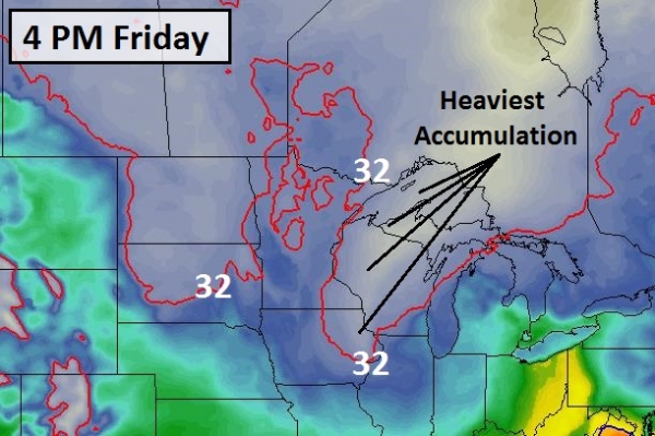
Cold Enough To Stick.
Although temperatures may rise just above 32F across portions of
Minnesota by Friday afternoon, readings in the lowest mile of the
atmosphere are forecast to stay well below freezing from northeast Iowa
into southeast Minnesota and much of western/central Wisconsin during
the day Friday, allowing snow to accumulate at the rate of 1-2"/hour at
times, creating very difficult travel conditions. Map: Ham Weather.
* The heavy, wet nature of this upcoming snowfall may increase the risk of
sporadic power outages
late Friday night into Saturday. Some ice will be mixed in with the
snow, especially Thursday, changing to mostly snow on Friday as colder
air wraps around the storm.
Winter Storm Watch.
NOAA has already blanced much of central and southern Minnesota and
west central Wisconsin under a Winter Storm Watch, meaning a potential
for 6" or more of snow in a 24 hour period. I suspect the heaviest snow
band may set up south and east of the Twin Cities, but it's going to be a
very close call. Right now the axis of heaviest snow appears to be
setting up from Waterloo, La Crosse and Rochester to Eau Claire and
Rhinelander, but it's still early, and that heavy snow zone may shift
50-100 miles east or west in the coming 48 hours.
Summary: I'm already seeing some (very early) evidence of a brewing
El Nino
warming phase in the Pacific, which tends to strengthen the southern
branch of the jet stream, invigorating storms over the central and
southern USA. I suspect this trend will continue into early summer, with
cooler weather over the northern states, and rapid warming in the south
setting the stage for more tornadoes and severe weather in general than we experienced in 2013.
Severe thunderstorms capable of isolated tornadoes are likely Wednesday
afternoon into Thursday night from the central and southern Plains into
the Mississippi and Ohio River Valleys. Staff should be alert for
potentially violent storms capable of large hail, damaging straight line
winds in excess of 70 mph, and a few tornadoes capable of more
widespread and significant damage. On the cold side of the storm another
major snow event is brewing from Iowa and Minnesota into Wisconsin from
Thursday PM into Friday. If it's any consolation (doubtful) long-range
model guidance shows 50s and 60s returning for this same region for the
latter half of next week. A rapid thaw may increase the potential for
mostly minor river flooding, but the slow melt of recent weeks has
helped to ease the overall risk, especially in the Red River Valley,
where the threat was greatest. We'll continue to monitor conditions and
have an update Wednesday.
A Hopeful Extended Outlook.
As we hear the sirens sounding, the weather threat upgraded to Defcon
2, preparing to ride out the next slushy slop-storm in our bunkers, keep
in mind that it is (in theory) spring, and at some point that higher
sun angle will start to make a real difference. ECMWF guidance shows 50s
returning next week, maybe 60s by Thursday. Whatever snow winds up in
your yard Thursday and Friday will be gone by early next week. That's
the "beauty" of an April snowfall. Graphic: Weatherspark.
70F By Mid-April?
No, I wouldn't bet much money on that prediction, but if you believe
the GFS we may come close to 70 within 2 weeks (give or take a month).
Notice the significant precipitation amounts by mid-month into the third
week of April; the atmosphere warm enough for mostly rain. I think.
Upper Midwest Blizzard Not Increasing Flood Fears.
Unless we pick up a few more major snowstorms or blizzards, followed by
rapid warming (and heavy rain) we may yet dodge a flooding bullet.
Here's an excerpt from
The Star Tribune: "
A
spring blizzard that dumped up to 20 inches of snow in parts of the
Upper Midwest isn't increasing fears of spring flooding. There wasn't
much of a flood threat going into Monday's storm, and the snow that fell
was light and without much moisture, according to National Weather
Service officials in North Dakota. "What we're expecting right now is
really not much," meteorologist Tom Grafenauer in Grand Forks said. "The
snow had an inch to maybe 2 inches of liquid equivalent in it. The
flood threat was very minimal before the snow, and an inch or two of
water isn't going to raise the flood threat significantly..."
File Photo credit: "
The Red River out of its banks just south of Moorhead in 2009." Photo: Marlin Levison, Star Tribune.
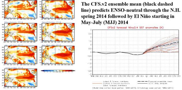
Higher Probability Of El Nino By Summer of 2014.
The threshold is .5C, and we should reach that in the Pacific as early
as May or June. For a little light reading and more than you ever wanted
to know about a brewing El Nino and ENSO in general, check out this 29
page PDF from
NOAA NCEP.
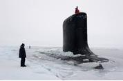
Parallel Parking In The Arctic Circle. If you missed Thomas Friedman's latest Op-Ed in
The New York Times it's definitely worth a read - with a son in the Navy I found this especially fascinating. Here's an excerpt: "...
More
important, you learn how crucial acoustics are when operating deep
under ice with no vision and no GPS satellite to guide you. Or, as the
New Mexico’s captain, Todd Moore, 40, put it: It’s like every day
“engaging in a knife fight in a dark room: the only thing you can do is
go after what you hear.” You can’t see the adversary. You can’t see the
ice keels, but you can hear enemy subs, surface ships, whales, calving
icebergs, schools of fish and bounce sound waves off them with sonar to
measure distances..."
Photo credit above: "
The U.S.S. New Mexico broke through the ice 150 miles north of the North Slope of Alaska to pick up some passengers." Credit Joshua Davies Communication Specialist 2nd Class/U.S. Navy Photo.
Don't Look Now: The Digital Ad Economy Is Heading For A Correction. Because who wants to be spammed with irrelevant ads on their smart phones and tablets? Advertising Age has the story; here's a clip: "...Michael Wolff recently opined that the evolution of TV is resulting in fewer people watching fewer ads. But the evolution of mobile (the medium poised to eclipse TV in the not-too-distant future)
may be an even bigger issue. The classic application of advertising
within mobile content and apps is fairly unnatural. Social media usage
has dominated the smaller, vertically oriented screens of mobile
devices, so what people are actually consuming is inherently different..."
People Can Predict The IQ Of Men, But Not Women, By Looking At Their Face. Deep down you always knew this, right? Here's an excerpt from
psypost.org: "
New research published in PLoS One
has found that a man’s facial characteristics contain some clues about
his intelligence. Surprisingly, the same can’t be said for women’s
facial traits. And the particular male facial characteristics linked
with intelligence are a mystery..."
The Depressing Truth Behind Michael Lewis' "Flash Boys": Even The World's Top Investors Don't Understand Today's Markets.
Is the stock market game rigged? Probably. And a new book from Michael
Lewis (author of "Liars Poker" among others) seems to confirm what many
of us have suspected for a long time. Here's an excerpt of a
story/review from
Quartz: "
The
ideas aren’t new. Unsavory elements of high-speed computerized trading
have been a concern since at least May 2010, when the so-called “flash crash”
struck US exchanges. (Die-hard market geeks were concerned long before
that.) But Michael Lewis’s new book Flash Boys, on the perils of
high-speed computerized markets, could still be important if only
because it cuts through the dense webbing of jargon and complexity that
has proven dangerous to the US financial system and the economy as a
whole..."
16 Airline Secrets That Will Change How You Feel About Flying. Great. Some things I wanted to remain blissfully ignorant about, but this story at
Huffington Post changed all that; here's an excerpt: "...
We've added a few of our own world-rocking facts to the list, and we've gotta tip our hat to Viral Quake
for posting some of the Reddit thread's most startling secrets. We
should also mention the validity of individual Reddit comments can't be
completely confirmed.That being said, we're already thinking about
flying from a whole new perspective.
Dim lights are meant to prepare you for evacuation, not sleep.
"When
a plane is landing at night, they dim the interior lights incase you
need to evacuate upon landing... your eyes are already adjusted to the
darkness so you'll be able to see better once outside the plane." --@
bonestamp
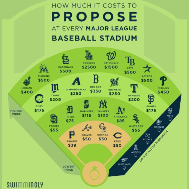
Here's How Much It Costs To Propose At Every Major League Baseball Park. $209 at Target Field? What a bargain! And yes, the proceeds go to charity. Here's an excerpt of real news you can use from
Swimmingly: "
Today
is Major League Baseball’s Opening Day, the start of the 2014 season.
That means it’s also the time of year for America’s second-favorite
pastime: the scoreboard marriage proposal. To step up your engagement
game, we reached out to all 30 MLB teams to find out the cost of
putting a ring (World Series or otherwise) on it at each stadium..."
Best April Fool's Day Jokes of 2014.
Time Magazine
has a rundown on some of the more unusual pranks yesterday, including
this one from Sir Richard Branson on one of his Virgin America flights. I
wish we could do this for Minnesota's weather: "
Virgin America partnering with Nest to create a personalized climate control feature on planes,
in which passengers can create their own climate at 35,000 feet, from
“Chicago Polar Vortex” to “Standard Day in Los Angeles.” (Virgin America)"
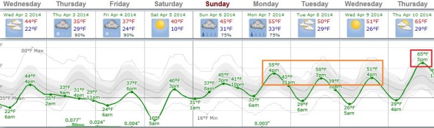
TODAY: Partly sunny, less wind. East 10. High: 45
WEDNESDAY NIGHT: Mostly cloudy, slushy snow possible late. Low: 32
THURSDAY: Winter Storm Watch. Rain-snow mix, sloppy roads. High: 39
FRIDAY: Winter Storm Watch. Plowable snow likely. Messy and slow travel. Wake-up: 30. High: 34
SATURDAY: Sun returns. Snow melts. Wake-up: 20. High: 43
SUNDAY: Mostly cloudy, a little drizzle. Wake-up: 32. High: 44
MONDAY: More clouds than sun @Target Field. Wake-up: 34. High: 47
TUESDAY: Partly sunny. Drama-free. Wake-up: 31. High: near 50
* 50s are likely the latter half of next week.
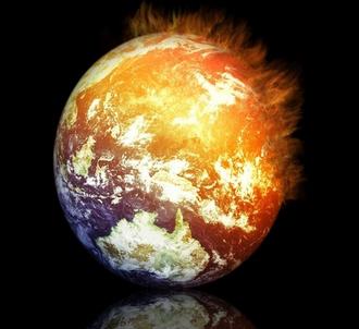
Climate Stories...
Climate Signals, Growing Louder. Here's an excerpt of an Op-Ed from the Editorial Board at
The New York Times: "
Perhaps
now the deniers will cease their attacks on the science of climate
change, and the American public will, at last, fully accept that global
warming is a danger now and an even graver threat to future generations.
On Monday, the Intergovernmental Panel on Climate Change, a United
Nations group that since 1990 has been issuing increasingly grim
warnings about the consequences of a warming planet, released its most powerful and sobering assessment so far. Even now, it said, ice caps are melting, droughts and floods are getting worse, coral reefs are dying..."
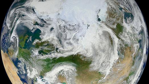
Warming World Threatens Us All, Warns U.N. Report. Time Magazine has an overview of the latest IPCC report; here's a clip: "...
So
the report predicts with high confidence that the negative impacts of
warming on crop yields will outweigh any potential positive impacts;
that violent conflict will exacerbate the effects of global warming;
that glaciers will continue to shrink as the climate warms, which has
major impacts for downstream water supplies; that species on land and in
the sea are shifting their range in response to warming and that some
will face an increased risk of extinction; that health impacts will be
felt from heat waves and from floods in low-lying areas; that the seas
will continue to acidify, destroying coral reefs..." (Image: NASA).
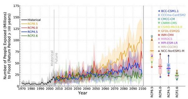
Climate Change Impacts In Pictures: 8 Stark IPCC Images. Here's an excerpt from a post at
Climate Central: "
100-year floods: More
extreme precipitation, expected with climate change, means that major
flood events could happen more often and thus more people are likely to
be impacted. By 2100, hundreds of millions of people per year are
projected to have to deal with the challenges flooding poses, the IPCC
shows in the above graph. That graph even keeps population steady at
2005 levels, meaning even more people will be under threat with
population rise. Averaged
globally, annual flood exposure increases 4-14 times over the course of
the 21st century compared to the 20th century. Using a moderate
population growth estimate increases that risk by 7-25 times..."

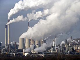
Exxon: Highly Unlikely World Limits Fossil Fuels.
We know it's bad for us, long-term, but in the short term we can't live
without it, right? Give Exxon Mobil some credit for acknowledging the
obvious: climate change is real. Here's an excerpt from a report at
ABC News: "...
The
report, the first detailed response to these concerns by a major oil
company, acknowledges the need to adopt policies to address climate
change. But it concludes that because oil and gas are so critical to
global development and economic growth, governments are "highly
unlikely" to adopt policies that cut emissions so sharply that fossil
fuel consumption would be severely restricted. "We know enough based on
the research and science that the risk (of climate change) is real and
appropriate steps should be taken to address that risk," Ken Cohen,
Exxon's government affairs chief, said in an interview Monday. "But
given the essential role that energy plays in everyone's lives, those
steps need to be taken in context with other realities we face,
including lifting much of the world's population out of poverty..."

GOP Rhetoric vs. Global Warming Reality. Here's a clip from a piece that caught my eye at
The Daily Beast: "...“
What’s
unique about this report is that it focuses so much on adaptation,”
says Peter Ogden with the liberal Center for American Progress.
Previously, the emphasis was on mitigation and persuading governments to
curb their output of greenhouse gases, which has yielded mixed results
at best. The scientific community and environmentalists downplayed
discussion of adaptation on the theory that it would let politicians off
the hook in making the tough decisions to reduce emissions. “This is
actually a very clear-eyed willingness by the scientific community to
acknowledge that while intent on doing what they can to mitigate climate
change we’re already experiencing it. We’re already living in a world
that is fundamentally changed,” says Ogden..."
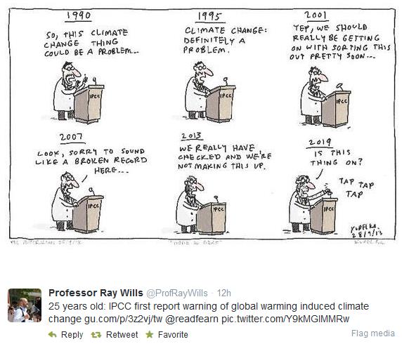
*
"The Hellish Monotony of 25 Years of IPCC Climate Change Warnings." Graham Readfern has the story at
The Guardian.
** Twitter cartoon credit
here.
Panel's Warning On Climate Risk: Worst Is Yet To Come. Justin Gillis has a good summary of the latest IPCC report in
The New York Times; here's an excerpt: "...
The
scientists emphasized that climate change is not just some problem of
the distant future, but is happening now. For instance, in much of the
American West, mountain snowpack is declining, threatening water
supplies for the region, the scientists reported. And the snow that does
fall is melting earlier in the year, which means there is less
meltwater to ease the parched summers. In Alaska, the collapse of sea
ice is allowing huge waves to strike the coast, causing erosion so rapid
that it is already forcing entire communities to relocate. “Now we are
at the point where there is so much information, so much evidence, that
we can no longer plead ignorance,” said Michel Jarraud, secretary
general of the World Meteorological Organization..."
MIT Scientist Responds On Disaster Costs And Climate Change.
FiveThirtyEight has an article from hurricane expert Kerry Emanuel from MIT; here's an excerpt: "...
The
increasing normalized trends in the U.S. were evident in convective
storms, winter storms, flooding events and high temperature-related
losses, and were almost statistically significant for hurricanes at the
conventional 95 percent confidence level.
In view of data like this, it’s very hard to accept Pielke’s confident
assertion that “[n]o matter what President Obama and British Prime
Minister David Cameron say, recent costly disasters are not part of a
trend driven by climate change...”

Wake Up To The Reality Of Climate Change. Here's an excerpt of an Op-Ed at
CNN that caught my eye, from former (Republican) Governor of New Mexico and U.S. Energy Secretary Bill Richardson: "...
We are now witnessing how it is changing our world: The past winter was the eighth-warmest on record. For 348 consecutive months -- 29 years
-- global temperatures have been above average. The latest IPCC report
finds that impacts from climate change are "widespread and
consequential" and they are being felt on every continent and in our
oceans. The world last year experienced 41 weather-related disasters
that caused damages totaling at least $1 billion. Over the past decade,
the western United States experienced seven times more large-scale wildfires than it did in the 1970s. Climate change has made it much more likely that we will suffer severe droughts like the one that recently swept across Texas and my home state of New Mexico..."
North America: Shifting Water. New Scientist examines how climate change will impact specific regions around the world. Here's an excerpt focused on North America: "...
Rain and storms will move northwards, flooding areas north of New York and leaving southern areas short of water.
Mexicans will have to do everything they can to preserve water and
escape the heat. Adapting to water deficits is not too hard: the key is
increased efficiency. But extra flooding is more problematic, with total
costs expected to increase tenfold this century. The US has the
capacity to adapt, but is struggling with misinformation and a lack of
political will..." (Photo: ThinkStock).
*
The Telegraph has a continent by continent breakdown of the risks and options related to a warming atmosphere and oceans.
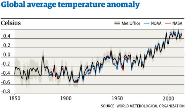
13 of 14 Warmest Years On Record Occurred In 21st Century - U.N. Here's a clip from a summary at
The Guardian: "
13 of the 14 warmest years on record occurred this century, according to the UN. Publishing its annual climate report, the UN's World Meteorological Organisation said that last year continued a long-term warming trend, with the hottest year ever in Australia
and floods, droughts and extreme weather elsewhere around the world.
Michel Jarraud, the WMO's secretary-general, also said there had been no
'pause' in global warming, as has been alleged by climate change
sceptics. “There is no standstill in global warming,” Jarraud said..."
Graphic credit: WMO (World Meteorological Organization) and The Guardian.
* A link to the latest IPCC WG2 Climate Summary is
here.
Food And Water Shortages May Prove Major Risks of Climate Change.
Scientific American has more on the implications of continued warming; here's a clip: "...
In that light, climate change becomes a risk management
proposition, particularly given the uncertainty about exactly how bad
impacts might become and when. The worst risks include sea level rise
for small islands and coasts, flooding, the breakdown of infrastructure
in the face of extreme weather, loss livelihoods forfarmers and fishers,
food insecurity and heat-wave deaths. Expect a big demand for energy for air conditioning
as the 21st century continues. Some of these impacts are already here,
from a meltdown of polar ice and glaciers everywhere to higher rates of
sea level rise than the IPCC predicted in the past..." (Image credit: NASA).


No comments:
Post a Comment