By Todd Nelson
I feel like I just got poked in the eye. It hurts to even look at the weather maps... I'm cursing the upcoming snow event as much as the next guy, but keep in mind that early April snow isn't necessarily that rare. Although, April in the Twin Cities only averages 2.4" (according to NWS NOWData from 1981-2010), we've had some fairly decent sized snow events in the past!
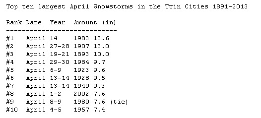
The UofM State Climatology Office recently released an article regarding "Historical April Snowstorms". They dug up information on a storm that dumped 28" of snow at The Old Pigeon River Bridge Crossing in Cook County in 1933. In 1893, an April storm unloaded 30" of snow in St. Cloud! That was also the year that the Twin Cities saw their greatest April snowfall of 13.6". We'd only need 7.4" to get into the top 10 greatest April snowfalls in history!
We will all likely be doing a little snow removal at some point within the next 24 to 36 hours as this obnoxious winter storm blows through. The good news is that snow pack at this time of the year tends to melt quickly, but be careful shoveling this heavy, heart-attack snow! Don't overdo it; take plenty of breaks. Think Spring!
=========
WEDNESDAY NIGHT: Cloudy, wintry mix develops late. Low: 31. Winds: ENE 5-15
THURSDAY: AM Wintry mix, sloppy roads, turning to heavy PM snow late afternoon/evening. 1" to 2" by evening. High: 37. Winds: ENE 10-20.
THURSDAY NIGHT: Heavy snow continues. Additional 3" to 5" by daybreak. Low: 28. Winds: N 15-30.
FRIDAY: Wind whipped snow continues early. Another 2" to 3" early by midday. Total shoveling 6"-10" across the Twin Cities (isolated higher amount in east-central Minnesota and into western/northern Wisconsin). Potentially treacherous travel early. High: 36. Winds: NNW 15-30.
SATURDAY: Bright white landscape. Sun returns. Snow melts. Wake-up: 22. High: 42.
SUNDAY: Mostly cloudy, a little drizzle. Wake-up: 27. High: 48
MONDAY: More clouds than sun @Target Field. Wake-up: 34. High: 48
TUESDAY: Slight chance of light rain/snow. Wake-up: 34. High: near 45.
WEDNESDAY: Springy. Turning sunny and warmer! Wake-up: 31. High: 58
=========
This Day in Weather History
April 3rd
1999: Ice storm hits Duluth and the Arrowhead. An 800 foot television tower in Duluth collapsed due to the weight of the ice.
1982: A sharp cold front causes the temperature at Lamberton in Redwood County to drop from 78 to 7 degrees. This 71 degree change in 24 hours is the maximum 24-hour temperature change in Minnesota.
1837: Snowstorm rages for four days at Ft. Snelling and dumps 9 inches.
========
Sunrise/Sunset Times
April 3rd
SUNRISE 650 AM
SUNSET 743 PM
========
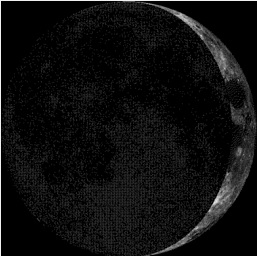
Moon Phase for April 3rd at Midnight
3.1 Days Before First Quarter
============
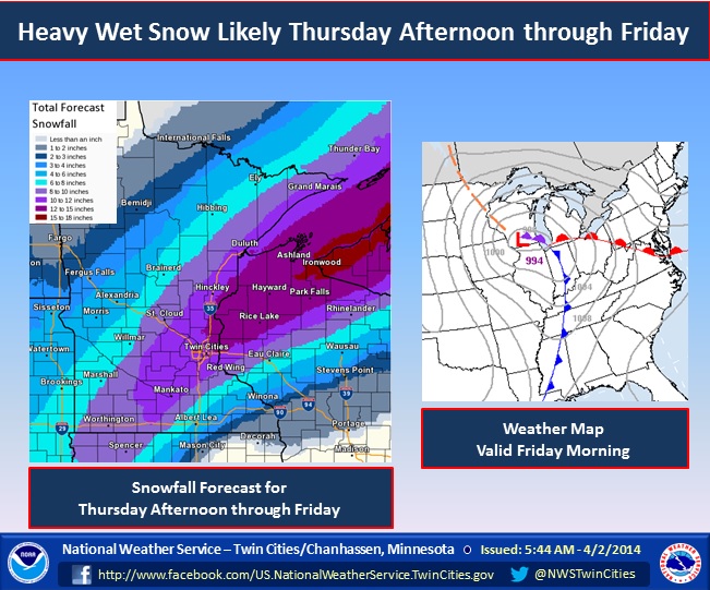
More Snow on the Way...
Say it ain't snow! This is getting ridiculous! Winter weather headlines have been posted for a large swath across the Upper Midwest from Thursday through Friday. The potential of significant snow appears to be growing in many areas, including the Twin Cities.
"A strong storm system will develop over the southern plains tonight and then move slowly northeast to southern Wisconsin by Friday morning. This system will likely bring a heavy wet snow to much of the region from Thursday night through Friday. Some light freezing rain is also possible across the area late tonight and Thursday morning."
Snow Potential
...SIGNIFICANT WINTER STORM IMMINENT FOR THURSDAY AFTERNOON THROUGH FRIDAY... .A WINTER STORM WARNING HAS BEEN ISSUED FROM SOUTHWEST MINNESOTA THROUGH NORTHERN WISCONSIN...INCLUDING THE TWIN CITIES METROPOLITAN AREA. A WINTER STORM WATCH REMAINS IN EFFECT FOR STEVENS...POPE...AND TODD COUNTIES IN WESTERN MINNESOTA...AND SOUTHEAST OF A LINE FROM BLUE EARTH IN FARIBAULT COUNTY MINNESOTA TO MENOMONIE AND BLOOMER IN WISCONSIN. A POWERFUL STORM SYSTEM WITH COPIOUS AMOUNTS OF MOISTURE WILL TRACK FROM THE SOUTHERN PLAINS TONIGHT TO MISSOURI BY THURSDAY NIGHT AND TO MICHIGAN BY FRIDAY NIGHT. A LARGE BATCH OF PRECIPITATION...BEGINNING AS A WINTRY MIX...WILL TURN TO ALL SNOW THURSDAY AFTERNOON OR EARLY EVENING AND CONTINUE THROUGH FRIDAY. THERE IS STILL SOME UNCERTAINTY AS TO WHEN THE MIX WILL TURN TO ACCUMULATING SNOW FROM FAR SOUTH CENTRAL MINNESOTA TO WEST CENTRAL WISCONSIN. SNOW WILL BE HEAVY AT TIMES THURSDAY NIGHT AND FRIDAY WITH 1 TO 2 INCH PER HOUR RATES POSSIBLE. THUNDERSNOW CANNOT BE RULED OUT... WHICH WOULD ENHANCE THE SNOWFALL RATES FURTHER. TOTAL SNOW ACCUMULATIONS OF 6 TO 14 INCHES ARE EXPECTED...WITH THE HEAVIEST AMOUNTS ALONG A LINE FROM FROM REDWOOD FALLS AND NEW ULM TO MONTICELLO AND CAMBRIDGE.
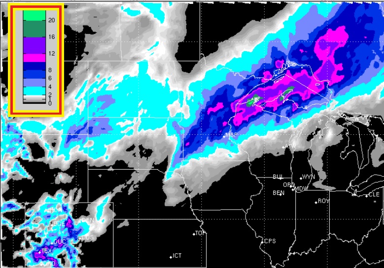
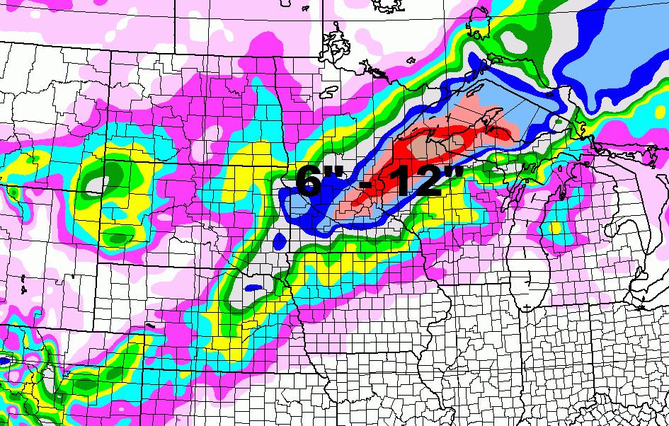
Substantial Snow Potential
Here's a glance of the snow potential across the Upper Midwest through AM Saturday. Keep in mind that the most significant snow snow will fall from PM Thursday through Friday. At this point, the heaviest appears to be from northern Wisconsin to the U.P. of Michigan, however, there will be some shovelable snow across much of Minnesota too!
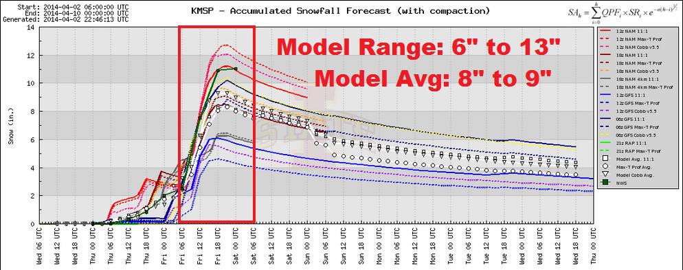
MSP Snow Outlook
Here's a wide array of snowfall forecasts from different weather models. As of Wednesday, the different weather model ranges were anywhere from 6" to 13" with the model average around 8" to 9". Snowfall amounts look to be quite a bit less as you head southeast from the Twin Cities as it will be mixing in with rain, freezing rain and sleet. Snowfall amounts will go up dramatically as you head north and east from the Twin Cities. I could see 12" or more across portions of northern Wisconsin and the U.P. of Michigan.
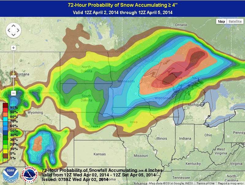
Probability of at Least 4" Snow or More
The probability of at least 4" of snow or more through AM Saturday appears to be the greatest across east-central Minnesota through the U.P. of Michigan. In fact, it's almost 100% that northern Wisconsin and the U.P of Michigan will in fact see 4" or more. The Twin Cities has a 70% chance of seeing at least 4" of snow or more.
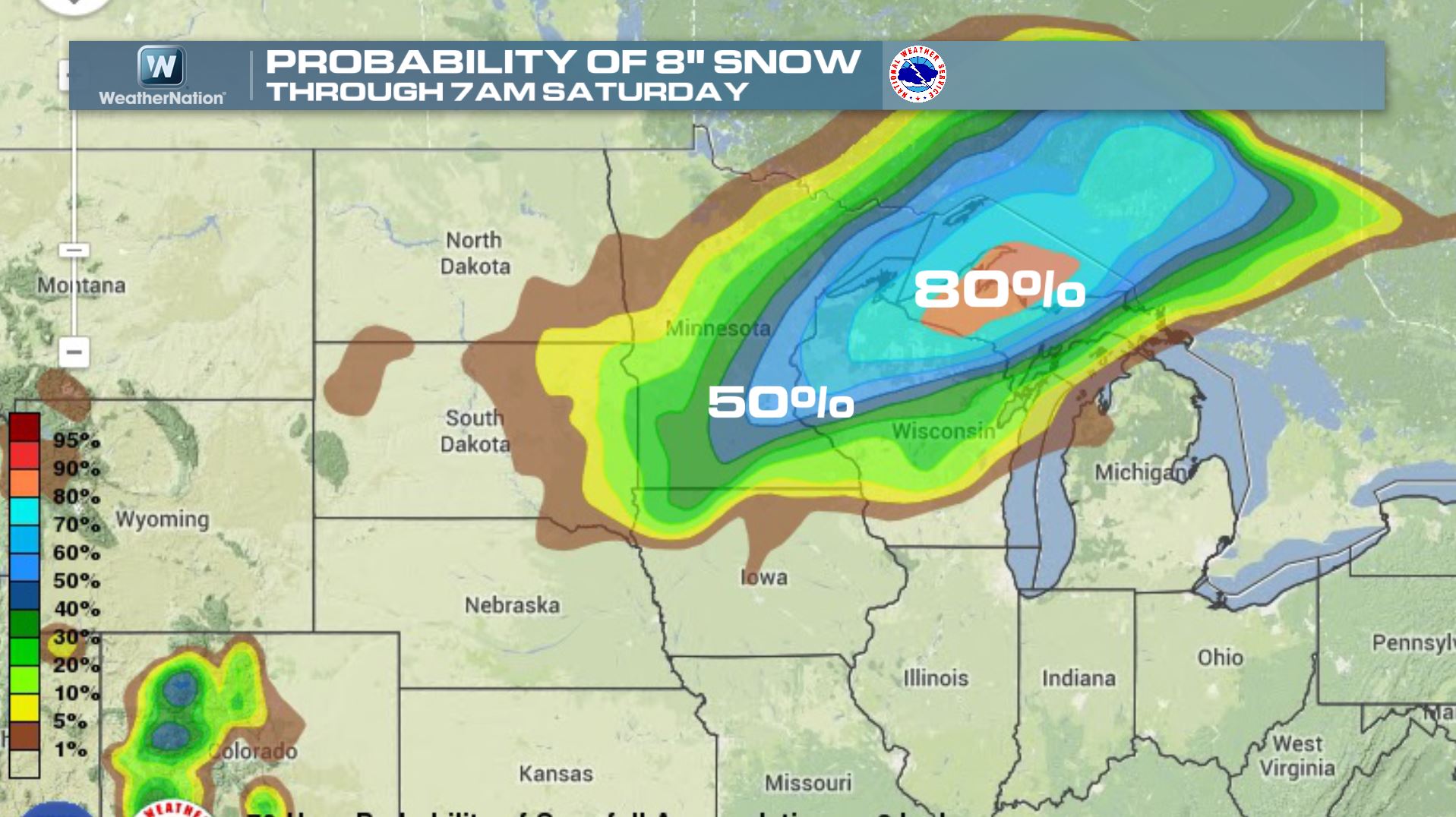
Probability of at Least 8" of Snow or More
The probability of at least 8" of snow or more drops a bit, but is still
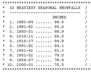
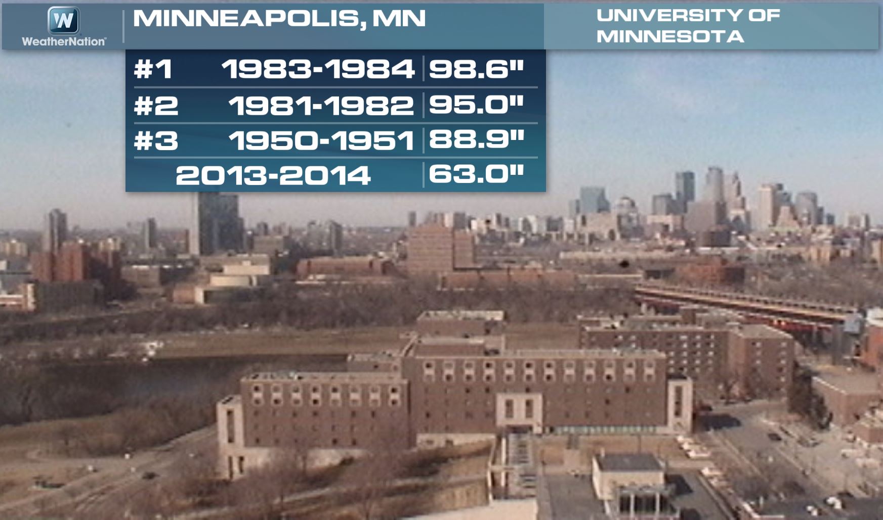
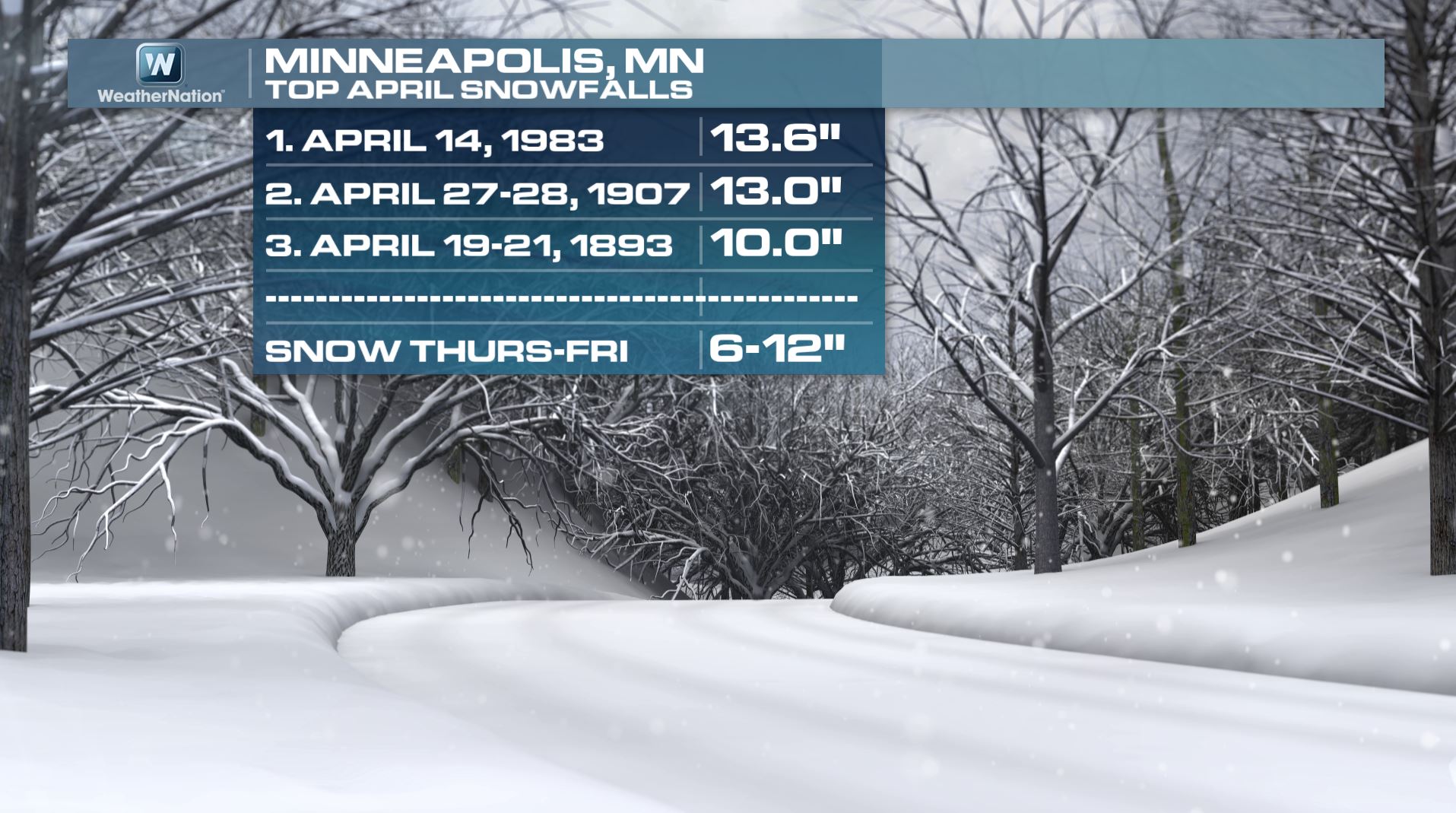
Minneapolis Snow Stats
By the way, as of Wednesday, April 2nd, the Twin Cities had seen 63.0" of snow this season. In order to get to the 3rd snowiest season on record, we'd still have to get another +2ft. of snow! However, we only need another 12.5" to get to the 10th snowiest season on record. Here's a list of the top seasonal snows in the Twin Cities:
April Snow Stats
Here's another interesting stat for you... If current forecasts hold, we could certainly be close to one of our top 3 April snowfalls on record! Here's a list of the top 10 April snowfalls on record for the Twin Cities:
"Heavy snows in April are fairly common in Minnesota's past. The transition from winter to spring can spawn some rather strong storms and given the right conditions, can also tap into leftover cool air from the winter. Looking through historical anecdotes, the greatest chance of having a large snowstorm appears to be in the first half of the month. One of the greatest April snowstorms (besides the April 5-7, 2008 event) was the storm that began on April 5, 1933. The old Pigeon River Bridge crossing in Cook County saw 28 inches in one day from that storm. This still stands as the 24 hour state record for snowfall in April. Two Harbors in Lake County saw 17 inches of snow from the 1933 storm. The largest April snowstorm in recent memory is the April 17-19, 2013 event that brought 17.7 inches at Duluth and 7.3 inches in the Twin Cities."
See the full story on Historical April Snows from the UofM Climatology Department HERE:
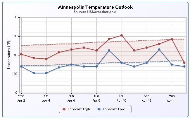
Minneapolis Temperature Trend
Where's Spring?! The temperature trend for Minneapolis through mid April appears to be consistently staying below average. We may sneak up close to 60 again by next week, but it doesn't look good in the near-term for any significant warming.
=================
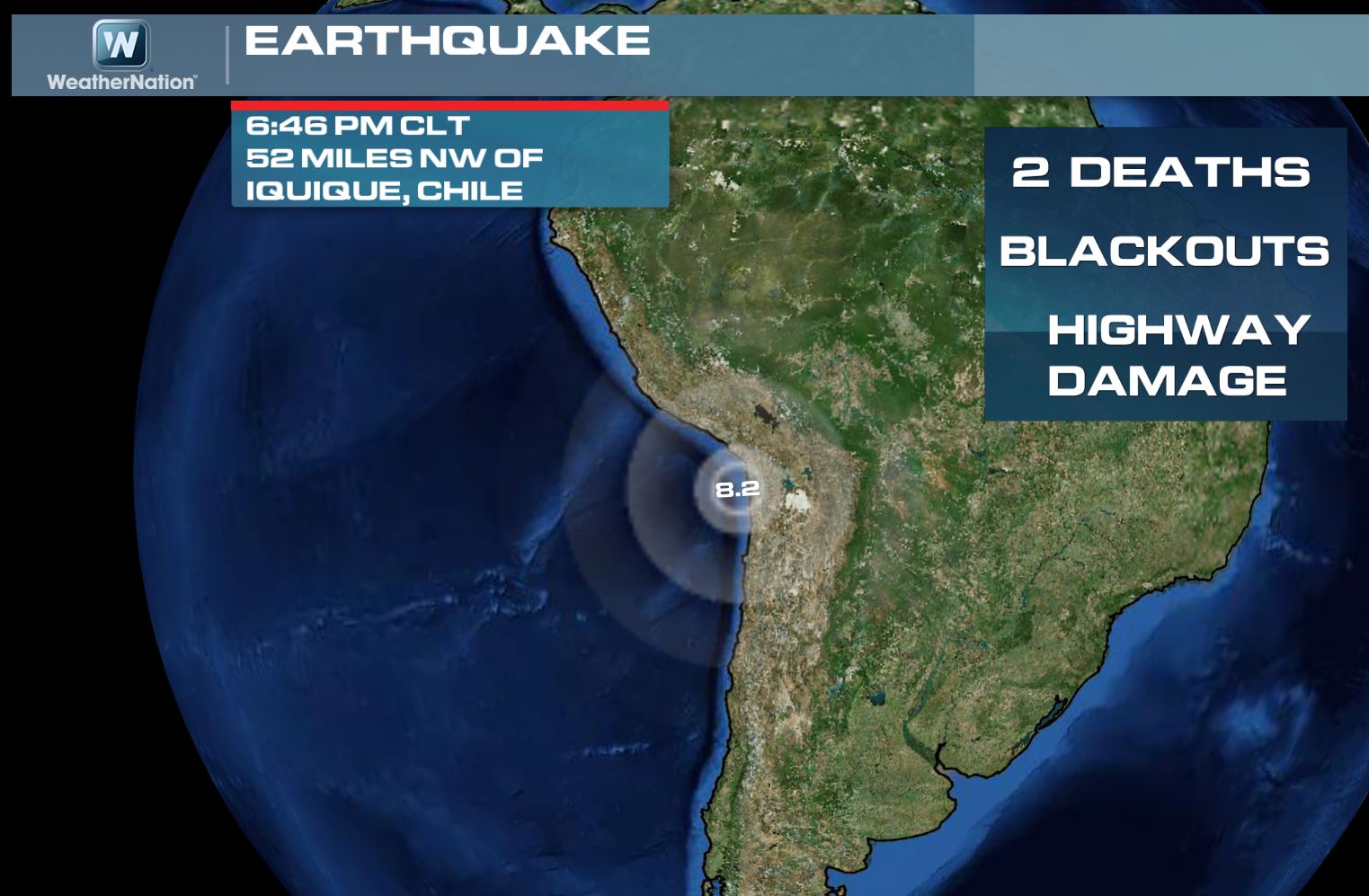
Chile Earthquake
The recent Chile earthquake on Tuesday evening was just another quake in the string of quakes to effect the Eastern Pacific region from North America to South America. This one, however, was MUCH greater than those in near Los Angeles, CA and Yellowstone National Park. I'm hoping this isn't turning out to be a trend...
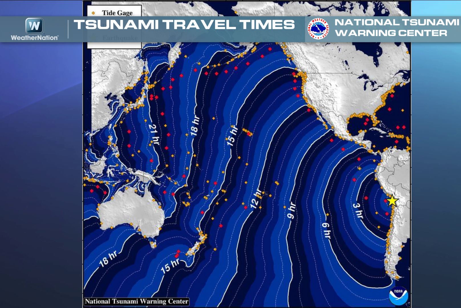
Tsunami Threat Immediately After Quake
This raised concerns of a Tsunami just after the quake. Note the forecast wave propagation map below hours after the quake off the Chilean Coast.
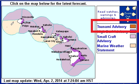
Interestingly, a Tsunami Advisory had been issued for the Hawaiian Islands through the morning hours of Wednesday in fear that the potential wave could have been hazardous to swimmers or boaters!
=================
Multi-Day Severe Threat
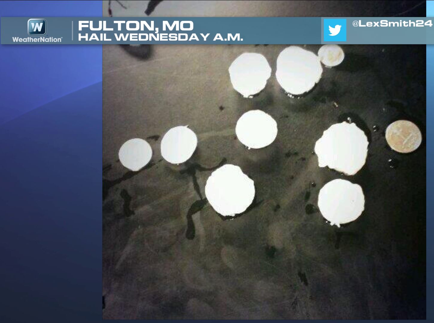
As we continue through the early part of April, strong to severe thunderstorm will be possible. This multi-day severe weather threat appears to continue through the end of the week; see more on that below. Here's a picture of hail that fell in Fulton, MO on Wednesday morning.
More hail in Columbia, MO from AM Wednesday
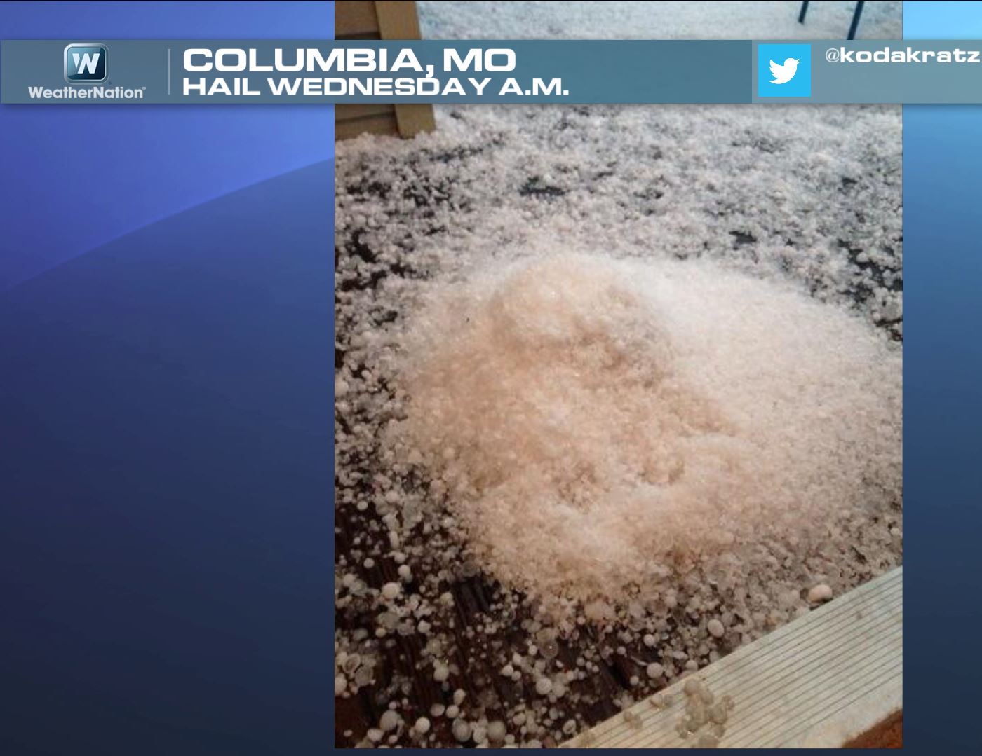
Thanks to @BCBaseballLeag for the picture below from Columbia, MO. Glad you didn't see baseball size hail there! The good news is that weather conditions will be improving by PM Friday/Saturday, so you might be able to use that grill you've covered up!

Lackluster Severe Season Thus Far
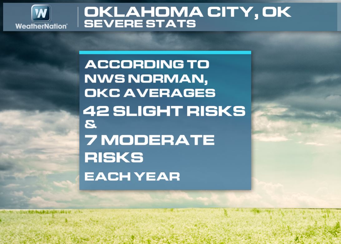
It certainly has been a quite severe weather season thus far. As of the April, 1st the PRELIMINARY tornado count across the nation was only 70. The 2005-2012 average is around 250! Interestingly, Oklahoma City, OK averages around 42 SLIGHT RISK days and 7 MODERATE RISK days per year.
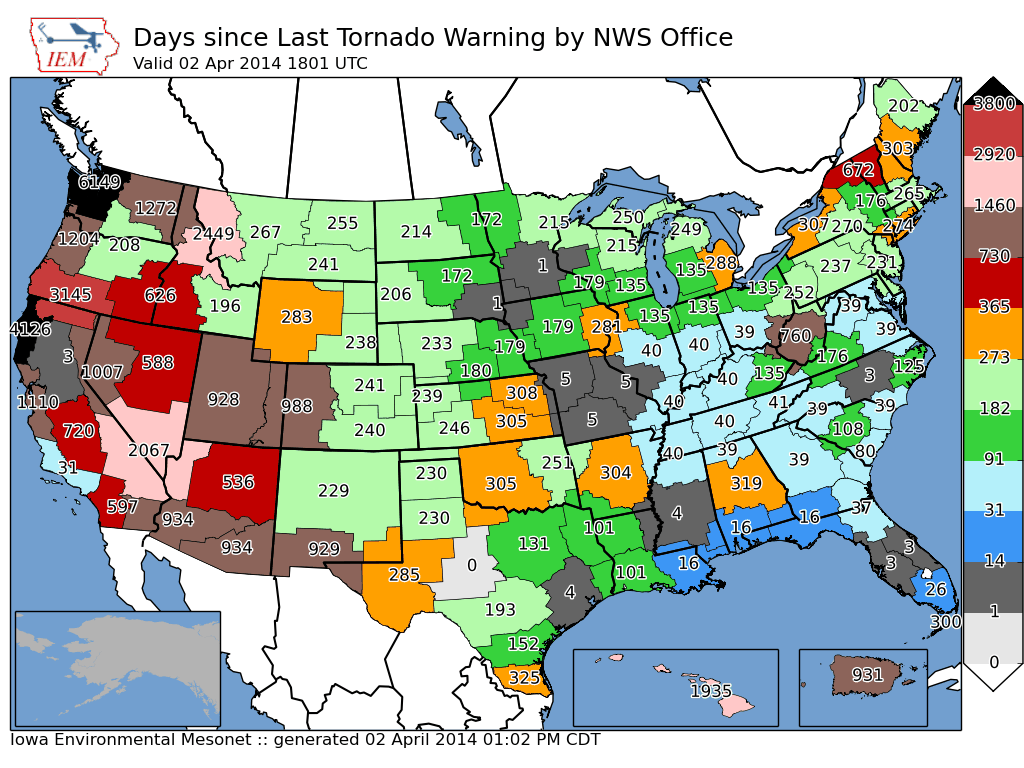
Days Since Last Tornado Warning
The graphic below from IEM, shows the number of days since the last tornado warning has been issued by any specific National Weather Service Office. Interestingly, there are several NWS offices in the central part of the country that (as of midday Wednesday) that have gone nearly 300 days or more without having a tornado warning issued in their country warning area! That certainly is a long since these are areas typically more prone to tornadic activity.
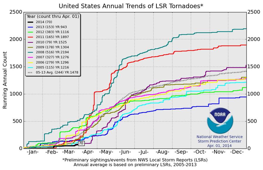
Tornado Warnings Issued January through March
This is another interesting look at how quiet this severe weather season has been. The graph below shows how many tornado warning have been issued during the January - March time frame across the nation. Note that 2014 has been nearly one of the quietest years since 1986. 2012 was a fairly active start to the year, while in 2008, there were more than 1,000 tornado warnings issue January - March!

2014 Tornado Reports
According to the Storm Prediction Center, as of April 1st, there have only been 70 PRELIMINARY tornado reports. Last year at this time, there were 153 by now; the (2005-2013) average is 244 PRELIMINARY tornado reports through April 1st.
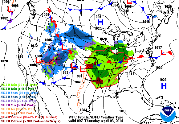
Stormy Weather Ahead
Here's the weather outlook through PM Friday. Note the large low pressure system wrapping up over the central part of the country through then. This storm will be very dynamic with heavy rain, severe storms and shovelable snow chances.
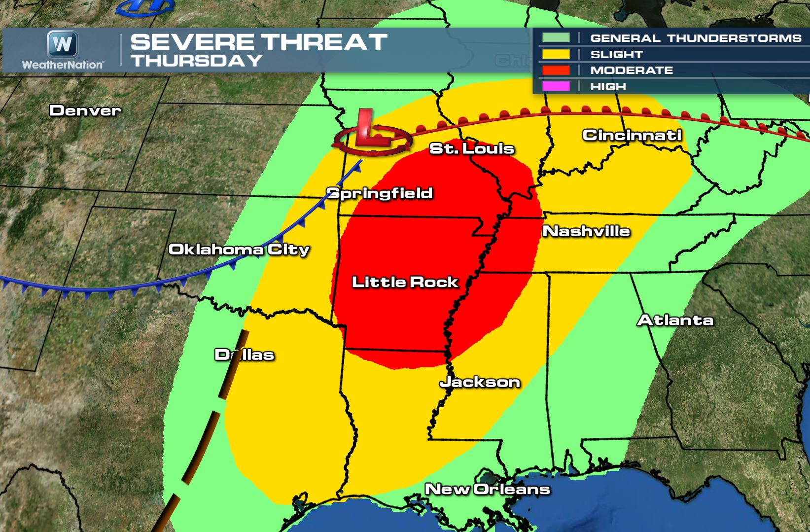
MODERATE RISK THURSDAY
The Storm Prediction Center has issued a MODERATE RISK of severe weather for Thursday as another impluse of energy from the Pacific moves into the central part of the country. This more vigorous wave of energy will help to promote more widespread severe weather for Thursday, which would likely be in the form of large hail, damaging winds and tornadoes!
Here's the latest thinking from the Storm Prediction Center:
...ERN SRN PLAINS THROUGH LOWER-MID MS VALLEY AND WRN TN VALLEY... LATEST MODEL GUIDANCE SUGGESTS EWD PROGRESSION OF UPPER TROUGH MAY BE A TAD SLOWER THAN PREVIOUS RUNS...BUT OVERALL TRENDS REMAIN FAIRLY CONSISTENT. A LARGE WARM SECTOR CHARACTERIZED BY MID 60S DEWPOINTS WILL BE IN PLACE AT THE BEGINNING OF THE PERIOD. SOME EARLY ELEVATED CONVECTION ASSOCIATED WITH STRONG WARM ADVECTION AND A WEAK UPPER IMPULSE IS POSSIBLE ACROSS PARTS OF THE LOWER AND MID MS VALLEY...BUT SHOULD QUICKLY MOVE N AND E AND IS NOT EXPECTED TO BE A CONCERN FOR LATER AIRMASS DESTABILIZATION. BY AFTERNOON...STEEP MID LEVEL LAPSE RATES GREATER THAN 7 DEG C/KM ATOP SFC TEMPERATURES IN THE 70S TO NEAR 80 F AND MID 60S DEWPOINTS WILL RESULT IN MODERATE TO STRONG INSTABILITY WITH MLCAPE VALUES PROGGED NEAR 1500-2500 J/KG. AS THE CAP ERODES WITH SFC HEATING...IT IS POSSIBLE A STORM OR TWO MAY DEVELOP IN THE WARM SECTOR ACROSS SE MO/ERN AR AS LOW LEVEL JET INCREASES BY LATE AFTERNOON. LARGE HAIL AND STRONG WINDS WOULD BE THE MAIN THREAT WITH THESE STORMS INITIALLY. HOWEVER...THE MAIN THREAT APPEARS TO BE FURTHER WEST FROM SW/S-CNTRL MO INTO NW/N-CNTRL AR JUST AHEAD OF EWD ADVANCING COLD FRONT. DEEP LAYER SHEAR AND LOW LEVEL HODOGRAPHS WILL BE FAVORABLE FOR DISCRETE SUPERCELLS CAPABLE OF VERY LARGE HAIL...DAMAGING WIND GUSTS AND TORNADOES. AS THE FRONT QUICKLY SHIFTS EWD...LOW LEVEL SHEAR WILL INCREASE AS WILL THE TORNADO THREAT. QUESTIONS REMAIN AS TO HOW LONG STORMS WILL REMAIN DISCRETE AS THE COLD FRONT BEGINS TO MOVE MORE QUICKLY EWD AS THE UPPER TROUGH BEGINS TO EJECT EWD...BUT AT LEAST A SMALL WINDOW EXISTS AROUND 00Z FOR DISCRETE CELLS. THEREAFTER...UPWARD GROWTH INTO ONE OR MORE QLCSS ARE EXPECTED TO DEVELOP AND MOVE ACROSS SE MO/ERN AR TOWARD THE WRN OH/TN VALLEY INTO THE EVENING...ACCOMPANIED BY AN INCREASING THREAT FOR DAMAGING WINDS.
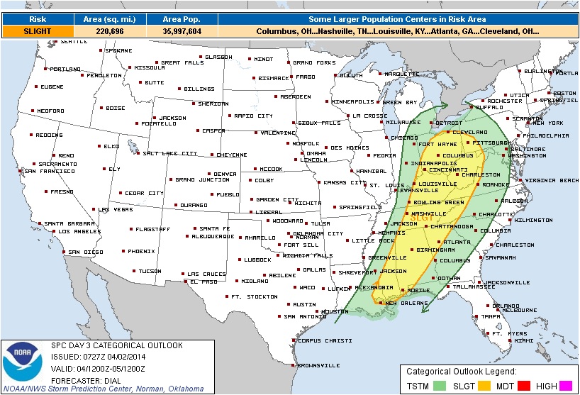
Severe Threat Friday
Here's the latest thinking from the Storm Prediction Center regarding Friday's storm potential:
...PORTION OF THE SERN STATES THROUGH TN AND OH VALLEYS... A PRE-FRONTAL SQUALL LINE SHOULD BE IN PROGRESS OVER THE OH...TN AND LOWER MS VALLEYS EARLY FRIDAY. SUFFICIENT PRE-CONVECTIVE INSTABILITY WILL EXIST IN THE PRESENCE OF STRONG DEEP LAYER WINDS FOR A THREAT OF DAMAGING WIND AS ACTIVITY DEVELOPS EWD DURING THE MORNING INTO THE EARLY AFTERNOON. HOWEVER...TENDENCY WILL BE FOR MOIST AXIS TO EVENTUALLY BE PINCHED OFF OVER THE OH VALLEY...WHILE THE STRONGER LOW-MID LEVEL WINDS AND DEEPER FORCING GRADUALLY LIFT NEWD AWAY FROM THE MORE UNSTABLE WARM SECTOR PRESENT OVER THE SERN STATES. THIS SUGGESTS GREATER SEVERE THREAT WILL BE FROM MORNING INTO MID AFTERNOON.
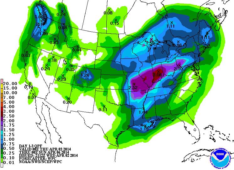
Heavy Precipitation Outlook
The several day rain/thunder event will have several inches of precipitation falling across the middle part of the country. Unfortunately, this could lead to some flooding in parts of the Ohio Valley.
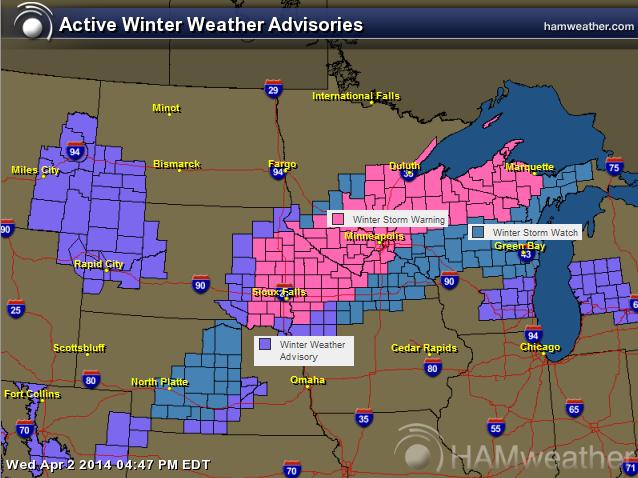
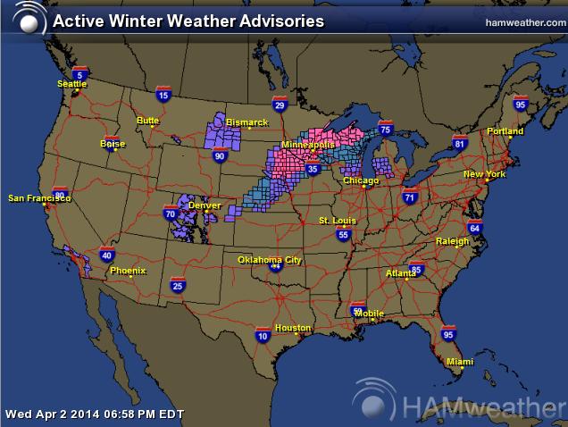
Winter Weather Headlines
Here are the winter weather headlines that have been posted by the National Weather Service. Note that some within the winter storm warned area (in pink) could see as much as 6" to 12" or more through Friday.
Upper Midwest Snow Potential
Thanks for checking in and have a great rest of your week! Don't forget to follow me on Twitter @TNelsonWNTV

No comments:
Post a Comment