18 F. low Tuesday morning, tying the all-time record set in 2002, 1935 and 1875.
36 F. high Tuesday afternoon in the Twin Cities.
58 F. average high on April 15. Was it April 15? Really?
40 F. high on April 15, 2013.
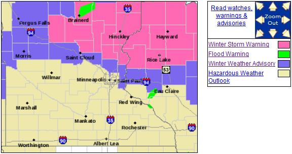
Coating - 7" possible today (best chance of plowable amounts far northern suburbs by tonight).
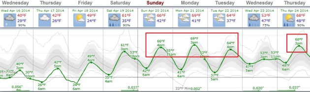
60 F. degrees returns next week, possibly as early as Easter Sunday.
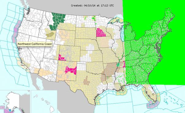
Plowable Just North of MSP?
Our
tormented April limps on: brief, wondrous spasms of warmth, interrupted
by extended spells of wind chill & fat flakes. By the time
mid-April rolls around Minnesotans do NOT want to hear about
"shovel-able snows".
With a higher sun angle and temperatures
above 32F in the metro most roads should remain wet, in spite of a
sloppy mix. We can't rule out a coating of slush in the metro area,
especially early this morning, with an inch or two north metro. If
you're driving north up I-35 travel conditions should get progressively
worse; mainly snow north of Monticello, Princeton and North Branch. Some
3-7+ inch amounts are possible by evening from central Minnesota into
northern Wisconsin.
Keep those driveway stakes in a little bit longer.
I
expect a "snow sandwich"; precipitation starting as a coating to 1 inch
of slush this morning, changing to rain, then back to snow at the
tail-end of the storm by this evening. Winds reach 25 mph, creating
treacherous travel up north, along with enough snow to build a
respectable slush-man from Brainerd and Duluth to Hayward.
Lovely.
Any primal screams today give way to contented sighs next week, with highs in the 60s, possibly as early as Easter Sunday, based on latest ECMWF guidance (below).
Easter egg hunts may be muddy this year; rain is likely Saturday into Easter Sunday. Good news for your greening garden.
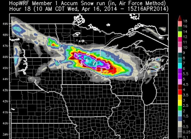
Coating - 7", Give or Take.
Go on TV and predict a coating to 7" and you'll be heckled. "Could you
possibly be any more vague, Paul?" But that's what the latest WRF
guidance is suggesting: as much as 3-7" for the north metro to near St.
Cloud, but only a coating for the southern suburbs. There may be a very
tight gradient in snowfall amounts across the metro area. Expect a cold
rain by afternoon, ending as an inch or two of slush south metro;
probably enough to shovel, plow (and complain vigorously about) north
metro. Source: HopWRF.
On Edge.
There's little doubt that the heaviest amounts of snow will fall north
of MSP later today and tonight. Today's storm should pull enough warm
air aloft for mostly rain midday and afternoon from the Twin Cities on
south to the Iowa border, but even in the immediate metro a cold rain
probably ends as an inch or two of slush. Northern suburbs may pick up a
few inches of slush, with the heaviest amounts far north metro, where
some 3-7" amounts can't be ruled out by Thursday morning. More details
on the Winter Storm Warning from NOAA.
A Light At The End Of Our Cold, Snowy Tunnel.
April is a volatile, fickle month - everything from blizzards and
floods to tornadoes. After another winter tantrum later today and
tonight skies begin to clear Thursday. ECMWF guidance suggests 60s by
Easter Sunday, with a rerun of spring much of next week. That would be
nice. Graphic: Weatherspark.
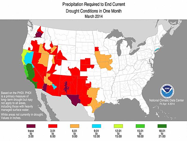
Precipitation Needed To End Drought.
Here are the latest numbers from NOAA NCDC; as much as 20" or more of
rain necessary to break the drought from California's Central Valley
southward to San Diego.
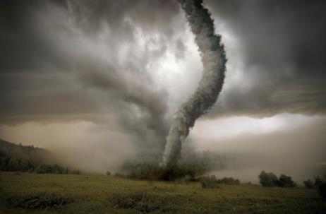
Tornado Season Is Off To A Slow Start, But There's No Predicting What's Next.
Matt Lanza has a very good summary of the (relatively) quiet start to
tornado season, nationwide, and what may be driving the low numbers.
Here's an excerpt from his story at
FiveThirtyEight Science: "
Tornado season has started quietly this year, continuing a trend that began in 2012. Through March 31, the United States had only 70 reported tornadoes
even though the first quarter has averaged more than 170 a year over
the last 10 years. April has remained quiet, with 36 preliminary tornado
reports as of Sunday. Oklahoma hasn’t seen an intense tornado since May 31, the longest such stretch on record. The small tornado seen there on Sunday was the first of any kind since Aug. 7..."
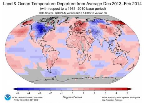
March Was 4th Warmest on Record Globally. Here are a couple of excerpts from a post at
Climate Central: "...
March
2014 was the fourth-warmest March on record globally, according to
recently released NASA data, making it the 349th month — more than 29
years — in which global temperatures were above the historic
average...This warm March follows on the heels of the announcements that
this winter was the eighth warmest globally and that 2013 was anywhere from the fourth- to the seventh-warmest year on record, depending on which data set is used."
Graphic credit above: "
The amounts that temperatures around the world differed from the historic average." Credit: NOAA.
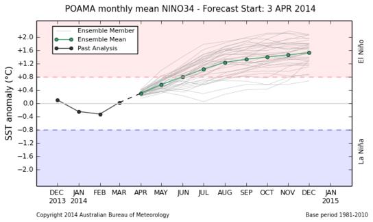
 If El Nino Comes This Year, It Could Be A Monster
.
Wired.com has the story; here's the introduction: "
Attention,
weather superfans: El Niño might be coming back. And this time, we
could be in for a big one. Official NOAA Climate Prediction Center
estimates peg the odds of El Niño’s return at 50 percent,
but many climate scientists think that is a lowball estimate. And there
are several indications that if it materializes, this year’s El Niño could be massive,
a lot like the 1997-98 event that was the strongest on record. “I think
there’s no doubt that there’s an El Niño underway,” said climate
scientist Kevin Trenberth of the U.S. National Center for Atmospheric Research. “The question is whether it’ll be a small or big one...”
A Significant El Nino Brewing?
It's still early, but leading indicators suggest a substantial warming
of equatorial Pacific Ocean water for the latter half of 2014. Data from
the
Australian Bureau of Meteorology show temperatures nearly 2F warmer than average in the Pacific by autumn: "
All international climate models
surveyed by the Bureau indicate that SSTs in the equatorial Pacific
Ocean will continue to warm during autumn and winter. Almost all models
indicate El Niño thresholds will be exceeded during the southern
hemisphere winter."
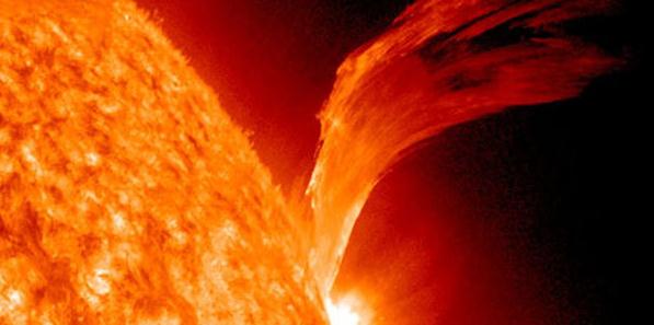
Earth Dodges A Huge Magnetic Bullet.
We've seen a number of close calls. If a Category 4-5 X-Class solar
flare ever reaches Earth's surface we won't be talking (or
communicating) much about weather annoyances. We'll have much bigger
problems to contend with, possibly a widespread loss of satellite
communication and the power grid. Here's an excerpt from
Electronic Products: "
I'd
say electronic engineers have not been terribly worried about a solar
event upsetting their designs. But maybe they should be worried.
According to University of California, Berkeley, and Chinese
researchers, a rapid succession of coronal mass ejections sent a pulse
of magnetized plasma barreling into space and through Earth's orbit on
July 23, 2012. Had the eruption come nine days earlier, when the
ignition spot was aimed at Earth, it would have potentially wreaked
havoc with the electrical grid, disabled satellites and GPS, and
disrupted our increasingly electroniclives..." (File photo: NASA).
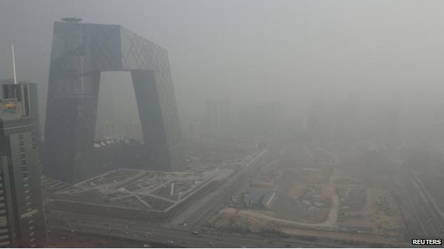
Asian Air Pollution Strengthens Pacific Storms. Smog spiking storms hundreds, even thousands of miles downwind from the source? Here's an excerpt of a
BBC article: "
Air
pollution in China and other Asian countries is having far-reaching
impacts on weather patterns across the Northern Hemisphere, a study
suggests. Researchers have found that pollutants are strengthening
storms above the Pacific Ocean, which feeds into weather systems in
other parts of the world. The effect was most pronounced during the
winter..."
Photo credit: Reuters. "
A thick haze of pollution envelopes Beijing - but scientists say the toxic air travels much further afield."
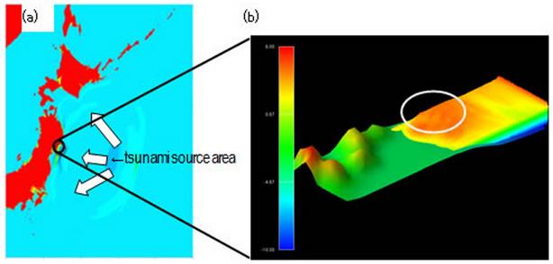
Fujitsu 3-D Tsunami Simulator Predicts Watery Disasters As They Unfold. Real-time predictions of tsunami impacts? Here's a clip from vr-zone.com: "Fujitsu’s
collaboration with Touhoku University led to the development of a 3D
tsunami simulator for high-precision tsunami forecasting....The 3D
tsunami simulator can recreate how a tsunami flows inland in very
accurate detail, showing the flow of water as it interacts with the
general topography of the area it is going to affect. It can also
simulate waves as it breaks and forms, and as it flows through obstacles
like urban buildings and local coastal geographic features..."
Tornadoes And Hurricanes And Earthquakes - Oh My! Surviving A Disaster In Your Home. I picked up a few timely tips and valuable suggestions in this
Living Green Magazine article from Ross Bishop; here's an excerpt: "...
The
lesson is, when the infrastructure goes, the one constant is that life
can be extremely difficult. And even a little preparation can make a
great deal of difference. Electricity is usually the first thing to go,
and our lives today are very electric dependent. No electricity means no
furnace, no lights, and no computer. It also means that the
refrigerator won't run and that you won't be able to recharge your cell
phone. Natural gas is more reliable, so you may have the stove for
cooking (even if you have to light it by hand), and you may have hot
water...."
The
lesson is, when the infrastructure goes, the one constant is that life
can be extremely difficult. And even a little preparation can make a
great deal of difference.
Electricity is usually the first thing
to go, and our lives today are very electric dependent. No electricity
means no furnace, no lights, and no computer. It also means that the
refrigerator won’t run and that you won’t be able to recharge your cell
phone.
Natural gas is more reliable, so you may have the stove for
cooking (even if you have to light it by hand), and you may have hot
water. The furnace however, needs electricity.
A flood, hurricane
or earthquake will put your water supply at risk. Even though you may
have water, it may not be safe to drink. Depending on where you live,
this may not happen very often, but the consequences are dire. You can
go without food for a month if pushed, but without water, you’ll die in a
matter of days.
Read more at http://livinggreenmag.com/2014/04/15/home-garden/tornadoes-and-hurricanes-and-earthquakes-oh-my-surviving-a-disaster-in-your-home/#R9SBXoeyGfoD4hGV.99
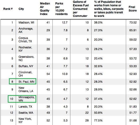
Twin Cities Crack The Top 10 Greenest Cities In America.
I found this interesting, and couldn't help noticing that St. Paul is
slightly ahead of Minneapolis on the list, but nowhere close to Madison
and Anchorage. Anchorage? Here's an excerpt from EcoWatch: "When a website creates a list with the title, “Greenest Cities in America,” it’s easy to think you know which ones will be included and why. NerdWallet’s list of that name does contain a couple overlapping municipalities with lists on the top solar cities or the most bike-friendly communities, for example, but it’s mostly comprised of cities that deserve far more recognition for their sustainable,
environment-focused efforts. California is typically associated with
being green, but not under the definition provided by NerdWallet, an
informational finance site..."
Graphic credit above: NerdWallet.
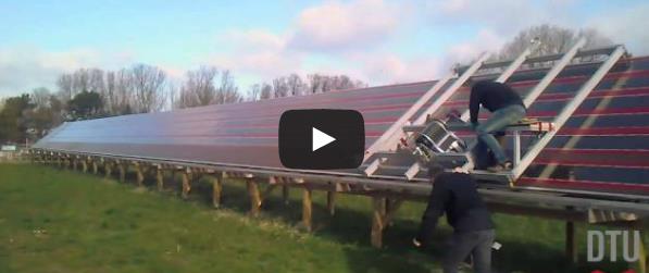
Turns Out, You Can Make Solar Panels Work In Cloudy Cities. Here's another article that made me do a double-take; an excerpt from
The Atlantic Cities: "
Solar
panels have always made sense in cities that get a lot of sun, at least
intuitively. But in recent years, scientists have figured out ways to
make them more useful for perpetually gloomy cities like London and
Seattle. The solution comes down to organic photovoltaics.
Unlike traditional solar panels, made of silicon, OPV cells are made of
organic semiconductors, which can be 3D-printed or coated over large
areas, as seen in the video below...."
What Riding On Airforce One Is Really Like. Here's an excerpt of an interesting behind-the-scenes story from The Washington Post: "...It
turns out that riding Air Force One is, in lots of ways, like flying
commercial. You need to get there hours early. You send your items
through a metal detector and get wanded down. The inside of the cabin
is, well, the cabin of a plane, but with some much nicer touches, like
real towels and hand lotion in the bathroom..."
Photo credit: "
Air Force One." (Katie Zezima)
New Leak Points To Major iPhone 6 Design Overhaul.
BGR has the latest on what may be coming next from Apple; here's an excerpt: "...
Apple is rumored to launch at least one bigger iPhone model later this year, with various reports suggesting that a 4.7-inch iPhone 6 would hit stores first,
at some point in late Q3. An even bigger 5.5-inch iPhone version has
also been detailed in many reports, with recent ones implying that
certain manufacturing issues may prevent Apple from launching it at the same time with the 4.7-inch iPhone..."
Image Source: Nowhereelse.fr
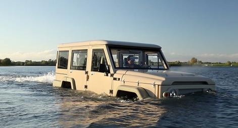
Amphicruiser: Amphibious 4WD Based On Toyota Land Cruiser.
And who wouldn't want to be seen in one of these pulling up to Big
Island on Lake Minnetonka on a busy Saturday afternoon? Here's a clip
from Gizmag: "We
wanted it to be as solid on water as the Land Cruiser is on land."
That's Dutch Amfibious Transport co-founder Dirk-Jan de Jong talking
about his company's heavy duty amphibious 4WD, the Amphibicruiser. Built
around a Toyota Land Cruiser engine, it's a fully fledged on and
offroad cruiser that can be driven up a river or out to sea with next to
no training..."
World's First Cannabis Vending Machine Unveiled In Colorado.
The Times of India has the mind-numbing details: "
A
dispensary in Colorado is making the most of the state's recent
legalization of cannabis by introducting the world's first marijuana
vending machines. The machine, called ZaZZZ, will work in a similar way
to cigarette machines but includes new technology that requires would-be
tokers to scan their driving license (or other, similar documentation)
before they can access the goods..."
Weather Service: Please Disregard Our Giant Biblical Flood Warning. Yes, even NOAA has occasional issues with their web sites, as described in this clip from
Mashable: "
NOAA,
meet Noah. The website for the National Weather Service (NWS), which is
part of the National Oceanic and Atmospheric Administration (NOAA),
suffered a major malfunction on Thursday leading to the false appearance
of a biblical flood warning spanning from Canada (which the NWS doesn't
even have responsibility over) south to Florida, and west to Michigan.
The malfunction, which began around midday ET and was fixed by 3:15 pm
ET, affected local NWS websites — key conduits for disseminating
life-saving watches and warnings..."
TODAY:
Rain-snow mix metro; mostly snow central Minnesota, where travel will
become treacherous. MSP coating - 2"; 3-7" north. Winds: E 20+ High:
near 40
WEDNESDAY NIGHT: Wet snow tapers to flurries - a few slick spots, plowable snow up north. Low: 27
THURSDAY: More clouds than sun, chilly. High: 42
FRIDAY: Partly sunny, almost spring. Wake-up: 25. High: 50
SATURDAY: Showers likely, possible thunder. Wake-up: 34. High: 58
EASTER SUNDAY: Milder under mostly cloudy skies. Isolated shower? Wake-up: 40. High: 62
MONDAY: Intervals of sun, getting better out there. Wake-up: 42. High: 64
TUESDAY: Fading sun. Welcome back spring. Wake-up: 45. High: 67
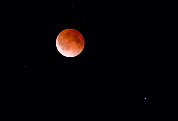
* Total lunar eclipse photo taken early Tuesday morning courtesy of photographer
Steve Burns.
Climate Stories....
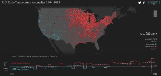
Tracking Temperature Anomalies Since 1968. A
friend shared this site with me yesterday, a fascinating look at
national temperature trends over the last 50 years. Check out the
Enigma Climate Data Engine for yourself: "
Every day, the Global Historical Climatology Network
collects temperatures from 90,000 weather stations. Dating back as far
as the late 1700's, the records provide an incredible source of insight
into our changing climate."
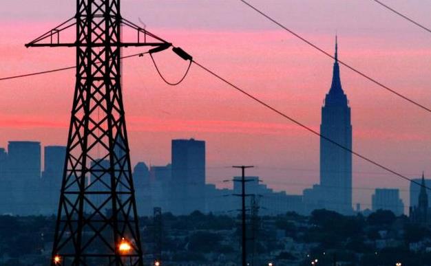
Climate Change Doubling Big Power Outages, Group Says. A story at
The Columbus Dispatch caught my eye; here's an excerpt: "...
The
study from Climate Central says that severe weather caused 80 percent
of the major outages from 2003 to 2013. A major outage is defined as one
that affects at least 50,000 people or interrupts at least 300
megawatts; 1 megawatt can power about 1,000 homes. “Heat waves are
hotter, heavy rain events are heavier, and winter storms have increased
in both frequency and intensity,” the report says. “To date, these kinds
of severe weather are among the leading causes of large-scale power
outages in the United States.” The number of major outages was double
that recorded during the prior 10-year period, though the author notes
that reporting requirements have changed, which might be driving some of
the increase..." (File photo: AP).
Canadian Economy Will Lose Billions To Climate Change: Report. Extreme droughts and floods, similar to what hit Calgary in 2013, may become the norm in the coming decades. Here's a clip from
thestar.com: "
A
new report on the financial implications of climate change notes that
while natural catastrophes are estimated to cost Canadians $21-$43
billion per year by 2050, popular economic measures like GDP fail to
capture the escalation, discouraging preventative investment. The TD
report follows a recent and alarming warning by the United Nations
Intergovernmental Panel on Climate Change that governments are ill-prepared for a warming world. If action is not immediately taken, the UN report projected risks could become unmanageable..."
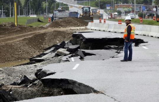
Photo credit above: "
A
road crew foreman surveys the washed-out lanes of northbound MacLeod
Trail in Calgary, Alta., Monday, June 24, 2013. Heavy rains caused
flooding, closed roads, and forced evacuations across Southern Alberta." THE CANADIAN PRESS/Jeff McIntosh.
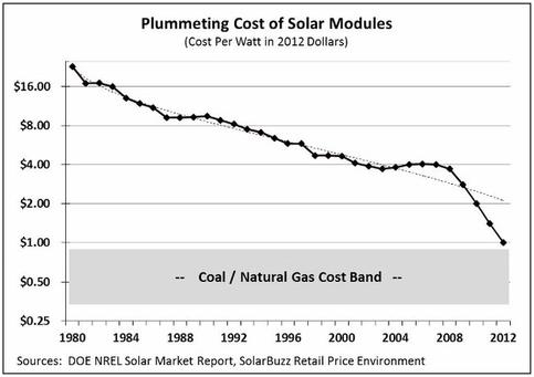
Rising Sun.
Why don't we hear more about the ongoing solar power revolution in the
popular media? Here's an excerpt of an Op-Ed from Paul Krugman at
The New York Times: "...
In
fact, it’s possible that solar will displace coal even without special
incentives. But we can’t count on that. What we do know is that it’s no
longer remotely true that we need to keep burning coal to satisfy
electricity demand. The way is open to a drastic reduction in emissions,
at not very high cost. And that should make us optimistic about the
future, right? I mean, all that stands in our way is prejudice,
ignorance, and vested interests. Oh, wait..."


No comments:
Post a Comment