38 F. high in the Twin Cities Monday.
57 F. average high on April 14.
38 F. high on April 14, 2013.
Winter Storm Watch much of central Minnesota Wednesday
Plowable snowfall possible from Brainerd to Crosby, Sandstone and Duluth.
60 F. high possible again by Easter Sunday.
Over the Horizon
There's
a better than 50/50 shot that El Nino is returning. A stain of
unusually warm water in the Pacific Ocean is gaining momentum, spreading
east, and it may flavor our weather here in Minnesota by the latter
half of 2014.
Every El Nino is different, but most warm phases of
the Pacific result in cooler, wetter summers for the Upper Midwest. It
may even take the edge off a deepening drought from California to the
southern Plains. El Nino events often energize the southern branch of
the jet stream; increased winds over the tropics often inhibit hurricane
development in the Caribbean. If El Nino remains in place odds would
favor a milder than normal winter next year.
Maybe we'll catch a break.
Maybe I'll delusional.
Please, no wagering. That's more of an exercise in hand-waving than a forecast.
A
push of chilly, dry air out of Canada sets the stage for a rain/snow
mix Wednesday. A few inches of slush may pile up from Brainerd and Lake
Mille Lacs to Duluth, but the sun is too high in the sky for snow to
linger.
Like turning on a light switch, a taste of May arrives
next week as a ridge of high pressure surges north. A string of 70s,
scattered T-storms? A real warm front!
* map above from NOAA NESDIS shows sea surface temperatures over the equatorial Pacific Ocean running 1-2F warmer than average.
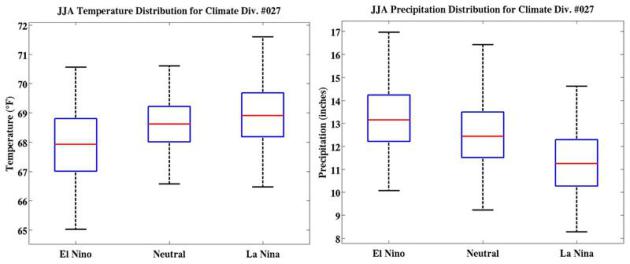
June - August: Slight Cool, Wet Bias?
Based on historical El Nino warmings of the Pacific Ocean Minnesota and
much of the Upper Midwest might expect a (very) slight bias toward
slightly cooler summer temperatures, with above-average precipitation,
due to a more active southerly branch of the jet stream. Graphic source:
NOAA Climate Prediction Center.
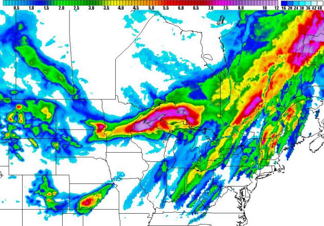
84 Hour Snowfall Potential.
NOAA's NAM model prints out some 2-5" snowfall amounts over central and
east central Minnesota; the heaviest band setting up 30-90 miles north
of the Twin Cities Wednesday. Map: HAMweather.
Another Plowable Pile?
Minnesotans tend to lose their sense of humor when there's accumulating
snow in the forecast in mid-April. It almost makes you want to throw
your remote control at the TV set, or drown your Macbook Air in the
bathtub (don't do it!) WSI's RPM model prints out some 4-8"+ amounts
from near Brainerd to Sandstone and the Duluth area. Some of that will
melt on contact, but Wednesday may very well wind up being a mess up
north.
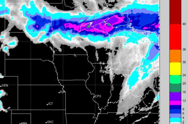
Potential For 4"+ Amounts.
NOAA guidance shows the greatest potential for significant slush from
central Minnesota into northern Wisconsin and the U.P. of Michigan, with
a snowy bullseye near Duluth and Superior. Map: HAMweather.
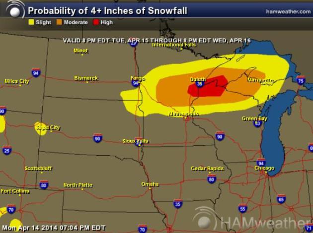
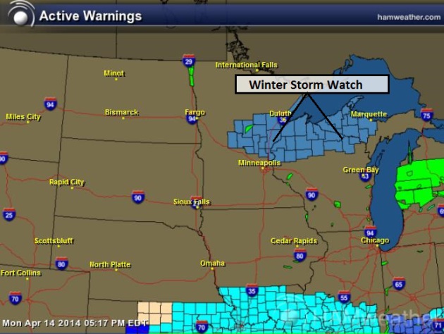
Winter Storm Watch.
This is rapidly turning into a meteorological edition of "Survivor",
but I still don't think winter will linger as deep into spring as it did
in 2013, when we had blizzard conditions across southeast Minnesota the
first week of May. That said, NOAA has issued a Winter Storm Watch just
north of MSP, including St. Cloud, Brainerd, Little Falls, Crosby,
Aitkin and Duluth, as well as a healthy chunk of northern Wisconsin.
Map: NOAA and HAMweather.
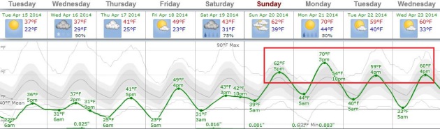
Reason To Keep Going Toward The Light.
Wednesday's near-death meteorological experience up north gives way to a
welcome rerun of spring, with 60 degrees returning as early as Easter
Sunday. ECMWF guidance suggests Monday will be milder, with temperatures
much of next week at or above normal. Graphic: Weatherspark.
Minor Flooding Reported In Aitkin.
In a relative sense we've been fairly lucky so far this spring. Snow
melted gradually, with no widespread heavy rainfall events to increase
snowmelt and runoff. But there have been a few minor problems; here's an
excerpt from The Brainerd Dispatch: "
The National Weather Service
(NWS) Monday issued a flood warning for the Mississippi River in Aitkin
and Crow Wing counties. At 9:30 a.m. Monday, the stage at the
Mississippi River at Aitkin was reported by NWS to be 12.8 feet. Flood
stage is 12 feet. Minor flooding was occurring and was forecast to
continue. The river is expected to continue to fall below flood stage by
Saturday..."
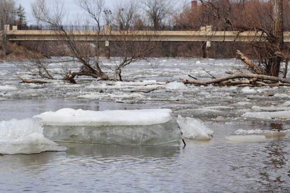
Photo credit above: Brainerd Dispatch/Steve Kohls. "
With
the College Drive Bridge in the background, Mississippi River ice is
gathering just south of Kiwanis Park Sunday as the river flow begins to
increase."
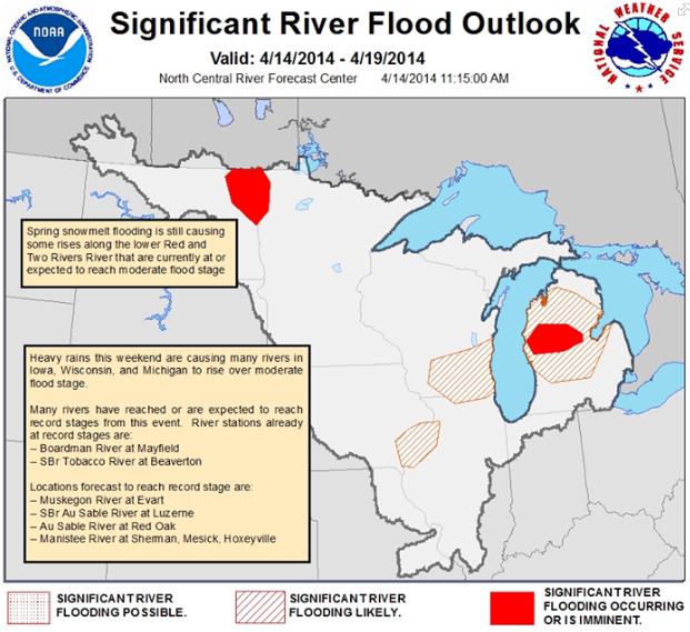
Significant River Flood Outlook. Here's an update from the
North Central River Forecast Center at The National Weather Service: "
Heavy
rains this weekend are causing many rivers in Iowa, Wisconsin, and
Michigan to rise over moderate flood stage. Many rivers have reached or
are expected to reach record stages from this event. River stations
already at record stages are:
-- Boardman River at Mayfield
-- SBr Tobacco River at Beaverton
Locations forecast to reach record stage are:
-- Muskegon River at Evart
-- SBr Au Sable River at Luzerne
-- Au Sable River at Red Oak
-- Manistee River at Sherman, Mesick, Hoxeyville..."
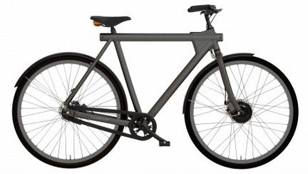
VANMOOF: An Option For Serious E-Bike Commuters.
I need the aerobic activity, but if you'd like an electric motor to
help with the hills (and GPS-tracking protection against theft) this
might be your ride. Details at
gizmag.com; here's a clip: "
One of the many interesting new e-bike designs that's floated across our desk over the past few years, the VANMOOF Electrified
is billed as the "world's first intelligent commuter bike." Not only
does it have the usual e-motor, it comes stock with an integrated GPS
anti-theft tracking system. VANMOOF has recently tweaked the design of
the bike and is moving toward launch..."
The Next Generation Airline Seat Will Know Everything About You. More than the NSA, or even Google? I doubt it, but this does look intriguing (and vaguely terrifying). Here's an excerpt from
Quartz: "
1. The seat knows who you are and what you want
"It is designed to remember you, based on a direct-connect to your personal electronic device. When
you place your device on the side panel, the seat’s voyeur-smart
computerized system connects to your social profiles and reads your data
footprint to learn what you like when you travel and in every other
area of your life. It
uses all that Big Data to determine what content you’re likely to want
to watch on the big screen which tilts as you do, as well as what
position you’ll like your seat to be in, what color side panel active
video display it should play to help you chill out, what kind of massage
setting you enjoy, and what your favorite onboard food is..."
Image credit above: "
Lean back and relax." Thales.
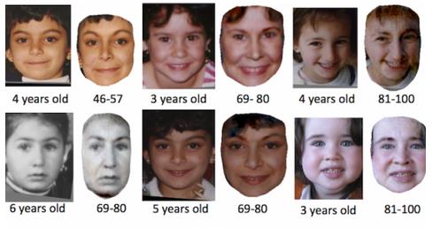
New Software Accurately Predicts What Your Children Will Look Like As Adults. This is informative, and just a little bit creepy. I'd rather be surprised. Details from
Gizmag; here's the intro: "
If
you're a parent wondering what your child will look like as an adult,
now you don't need to wonder anymore. Researchers at the University of
Washington claim to have developed software that can accurately predict
what a child will look like as an adult, up to the age of 80. The
technique can even work from poorly lit photos, and could prove a big
help in missing persons cases..."
Image credit above: "
New software from the University of Washington can accurately predict what your kid will look like as an adult." (Image: University of Washington).
Alaska Man Blows Nose After Being Punched, Eyeball Pops Out.
And you think you had a rough day. Remind me not to blow my nose after
being punched in the face. Here's an excerpt of an awe-inspiring story
at
Alaska Dispatch: "...
The
police noted that the victim “had never had an experience where his
eyeball popped out when he was blowing his nose, and this incident
occurred as a direct result of the injury that he received after being
punched in the eye by the male subject..."
TODAY: Cool sunshine. Still bug-free. Winds: West 8. High: 41
TUESDAY NIGHT: Clouds increase, wet snow possible late. Low: 31
WEDNESDAY: Slushy mix of rain and wet snow; few inches central Minnesota. High: 39
THURSDAY: Blue sky, better travel day. Wake-up: 26. High: 42
GOOD FRIDAY: Some sun, a dry sky. Wake-up: 29. High: 49
SATURDAY: Cloudy with a cold rain. Wake-up: 31. High: 45
EASTER SUNDAY: Milder with sunny breaks for Easter. Wake-up: 40. High: near 60
MONDAY: Partly sunny, springy again. Wake-up: 42. High: 70
Climate Stories....
Climate Change Action: Faith Community Called to Lead by Example. Here's a post from a story at
Christian Post: "...
Pro-environment
groups are calling on the faith community to come together and lead by
example when it comes to taking action on climate change issues. "The
challenges our world faces in mitigating climate change now requires
uniting with an unprecedented global-community mindset. Some
soul-searching is in order for faith based organizations and houses of
worship who are abdicating our moral responsibility to our most
vulnerable neighbors in the developing world when we don't lead by
example and refuse to tolerate any less from our business and government
leaders on climate change," said Deborah Fikes, representative to the
United Nations for World Evangelical Alliance and Clean Revolution
Ambassador, in a statement Friday..."
Photo credit above: Water Missions International. "
Uganda children at a water tap in this undated photo."
Years of Living Dangerously. Did you catch the
premiere episode
on Showtime Sunday evening? It was very well done, showing how climate
change has gone from a theoretical abstraction to a reality; impacting
people around the planet. The approach is at once unconventional (think
Harrison Ford as one of the reporters), but effective, and ultimately
empowering and hopeful in tone. Here's an excerpt of a review from
Media Matters: "...
Although
the premiere episode of "Years Of Living Dangerously" doesn't touch on
any solutions to climate change, the series promises to address
solutions in later episodes, including segments on renewable energy, global warming as a political priority, and the "greening" of the corporate sector. According to a study from
the Tyndall Centre for Climate Change Research, painting a dire picture
of climate change without providing a solution may cause an audience to
reject the message, echoing previous research. As a recent study shows
that most broadcast evening news shows often decoupled solutions from
messages about the threat of global warming, the Showtime and NBC series
again provide a fresh take on the issue by including possible solutions..."


No comments:
Post a Comment