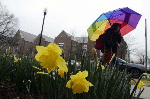
False Spring
"April
showers bring May flowers". The prevailing wisdom is that spring rains
cause flowers to bloom, on cue. But recent research suggests spring
bloom times are more a function of temperature than moisture.
An
article on today's weather blog (below) shows flowering times for 23
native species across Wisconsin have shifted from May 7 (1935-1945) to
May 1 (1977-2012). The authors of the paper point out the rising
incidents of "false springs", where unusually early surges of March
warmth trigger premature blooms, only to be followed by hard, killing
frosts & freezes.
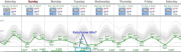
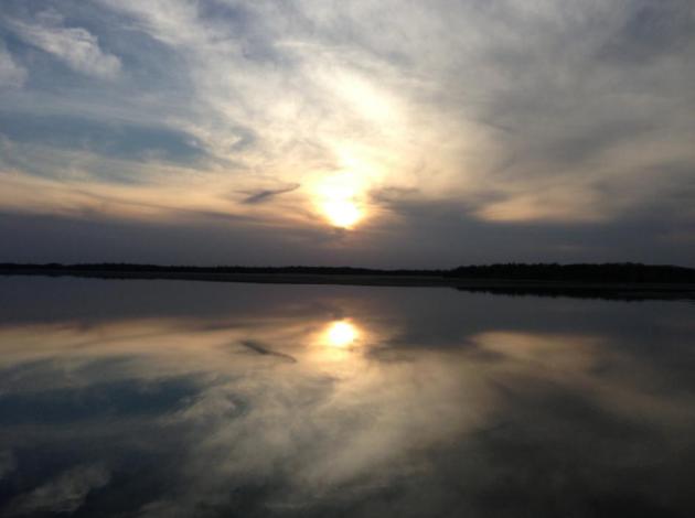
Gazing at the weather maps I'm wondering
about our tenuous spring. Clouds increase today, a stiff east breeze
with daytime highs stuck in the 50s - as mild as it's going to get
looking out into next Thursday. Showers arrive Sunday; steadier/heavier
rain Monday before a brief clearing trend Tuesday. A temporarily stalled
storm "retrogrades", pinwheeling moisture back into Minnesota
Wednesday/Thursday - precipitation approaching from the east!
It
pains me to say this out loud, but the atmosphere may be marginally cold
enough for a rain/snow mix Wednesday. Accumulation? Probably not.
ECMWF models show 60F the end of next week.
Do April Showers Bring May Flowers?
Temperature may be more of a signal for the flowers in your yard than
rainfall, it turns out. Here's an excerpt of a very interesting article
with new research finds at
FiveThirtyEight: "...
Rain,
in general, has an effect on timing and abundance of flowering, said
David W. Inouye, a biology professor at the University of Maryland,
College Park. Inouye, who has studied bloom times in
the Rocky Mountains, noted that some plants flower at the start of a
rainy season and that some species might flower a second time in late
summer, following a good soaking. But for most species, first flowering
is more closely tied to temperature than to rain..."
Shades of March.
Forget late April. No more 60s for a week or more. A slow-moving storm
will pull unusually chilly air south of the border (again), meaning
highs in the 40s to low 50s much of next week. A cold rain is likely
much of Sunday and Monday, possibly mixing with a little wet snow
Tuesday. Right now I don't see accumulations in the metro area, although
a couple inches of slush could pile up on lawns and fields up north.
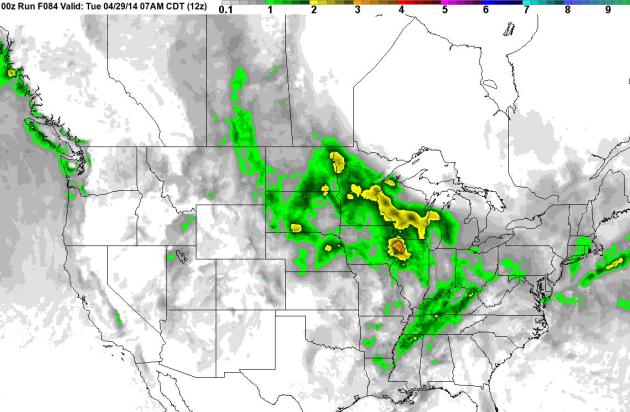
April Soaking Upper Midwest.
NOAA's NAM model prints out some 1-2" rainfall amounts over the next 84
hours from the Dakotas to Minnesota, Wisconsin and northern Illinois.
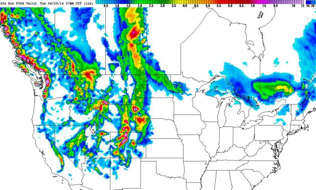
It's Spring - In Theory.
The latest NAM snowfall accumulation shows potentially plowable amounts
of snow for the central and northern Rockies, maybe a couple inches of
slush from the western Dakotas into the Red River Valley of Minnesota
early next week.
Alerts Broadcaster Briefing: issued Friday by Media Logic meteorologist Andy Mair.
-
We are preparing for a multiday severe weather threat starting tomorrow
through next Tuesday. Sunday is looking to be the worst day of the
bunch with a day 3 moderate risk already issued. Hail will be the main
threat tomorrow, but Sunday will pose a threat for large damaging, long
track tornadoes.
THE RIGHT MIX OF INGREDIENTS
-
Much like baking a cake, the perfect set of ingredients will come
together this weekend allowing several days of severe weather to kick
off. A low pressure system will form over the Rocky Mountains tomorrow
afternoon and begin moving to the east stirring up severe weather. This
will give the wind speeds and direction needed for severe supercell
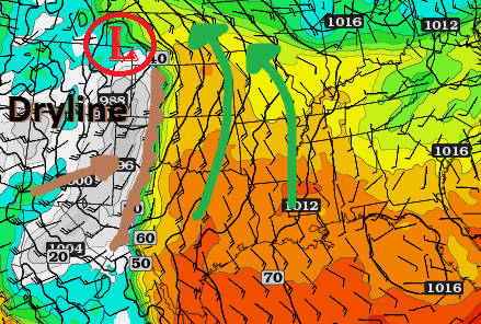
development. As you can see below, the low pressure will be pulling up
warm moist air from the Gulf of Mexico while at the same time be driving
the dryline east. This will create an explosive environment the next
few days.
-
A dryline will form just the east of the Rockies and will create the
needed forcing for severe storms. Drylines are best known for their
ability to generate discrete supercells that can create violent
tornadoes.
SATURDAY
-
The Storm Prediction Center has issued a slight risk for Saturday from
south central Texas up through Oklahoma and central Kansas. This will be
the start of our multiday severe weather threat. Above shows the 30%
risk area, but also a hatched region. The hatched regions indicate a 10%
higher risk of F2 or larger tornadoes, 2 inch or greater hail and
damaging winds in excess of 65kts.
-
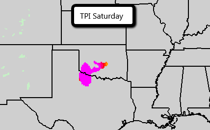
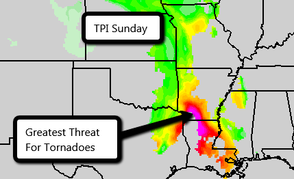
Above is our in house TPI forecast model. You can see the bright pinks
where the greatest tornado threat exists tomorrow. Storms are expected
to begin firing in the early evening in western Oklahoma and move to the
east through the risk area and die in Missouri overnight. Main threat
will be hail, but we cannot rule out the chance for some tornadoes.
SUNDAY (POTENTIAL OUTBREAK DAY)
-
Sunday is shaping up to be the most dangerous day during this severe weekend.
It is believed by much of the meteorological community that what a
weather system has done the previous days will tell you what can be
expected about the current risk. So pay attention to what happens
tomorrow and it may be a key as to what can be expected Sunday.
-
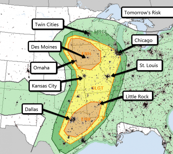
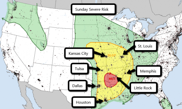
Here is the current risk from the SPC. You can see a moderate risk
already exists for much of Arkansas and a slight risk is in place from
Iowa down through Texas. Many large metropolitan cities are at risk
Sunday including Dallas, St. Louis and Kansas City. Little Rock is
currently in the most danger being located in the moderate risk.
-
When the SPC issues a moderate risk on day 3 it almost always means that a high risk will occur on the day of the storm.
-
When
a high risk is issued any watches in that area are required to be a PDS
watch. PDS stands for Particularly Dangerous Situation. If you hear PDS
mentioned you need to pay extra special attention to the weather that
day.
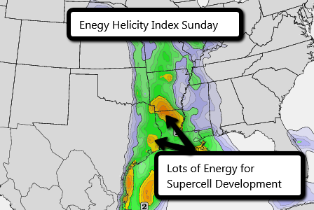
-
A common tool used for forecasting severe weather is EHI (Energy
Helicity Index). The brighter colors on the map indicate areas where the
best cross over between instability and wind shear. This is the kind of
environment supercells need to create long lived damaging tornadoes.
You can see the bulls eye right over the current day 3 moderate risk.
-
Our TPI forecast on Sunday is off the charts maxing out at 5.
As it stands right now, this day may be an outbreak event. Large hail,
damaging winds and long track tornadoes are all possible. If you live or
work in this area please review your severe weather safety plans and
procedures.
Make sure everyone is on high alert!
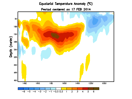
Is A Powerful El Nino Brewing In The Pacific Ocean?
Odds statistically favor an El Nino warming phase of ENSO by the latter
half of 2014; the question now is how strong will it be. Here's an
excerpt from a post at
Skeptical Science:
- The current large build-up and eastward movement of heat in the equatorial subsurface ocean strongly hints at a powerful El Niño developing this year.
- A
powerful El Niño is by no means guaranteed, but should one develop
mid-2014 to mid-2015 would likely be the hottest 12 months ever
recorded. Unfortunately widespread weather-related chaos and mass coral bleaching is almost certain to follow.
*
image above courtesy of NOAA CPC.
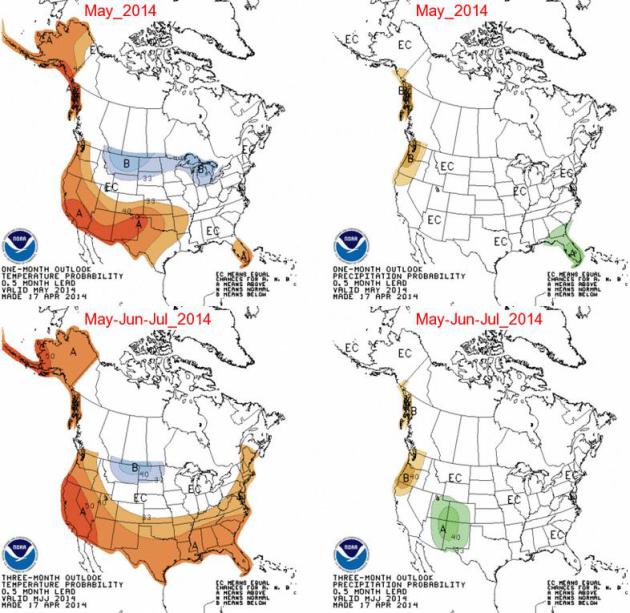
NOAA CPC: Cool Bias For May.
Here is the latest 30 day outlook for May, and an extended outlook into
the summer months, showing a warm bias for much of the west, south and
eastern USA, with a lingering cool/wet bias from the northern Rockies
and Midwest into the Great Lakes. One big factor that's flavoring this
prediction: El Nino, which is forecast to strengthen into the summer
months. Credit:
NOAA.
TODAY: Clouds increase, cool breeze. Drier day of the weekend. Winds: E 15. High: 55
SATURDAY NIGHT: Mostly cloudy with showers developing. Low: 40
SUNDAY: Showers likely. Windy and damp. High: 51
MONDAY: Heavier, steadier rain likely. Wake-up: 42. High: 48
TUESDAY: Partial clearing, still brisk. Wake-up: 43. High: 53
WEDNESDAY: Rain, possibly mixed with snow. Wake-up: 38. High: 41
THURSDAY: Showers taper. Raw for May 1. Wake-up: 37. High: 51
FRIDAY: Peeks of sun, hints of spring return. Wake-up: 38. High: near 60
Climate Stories....
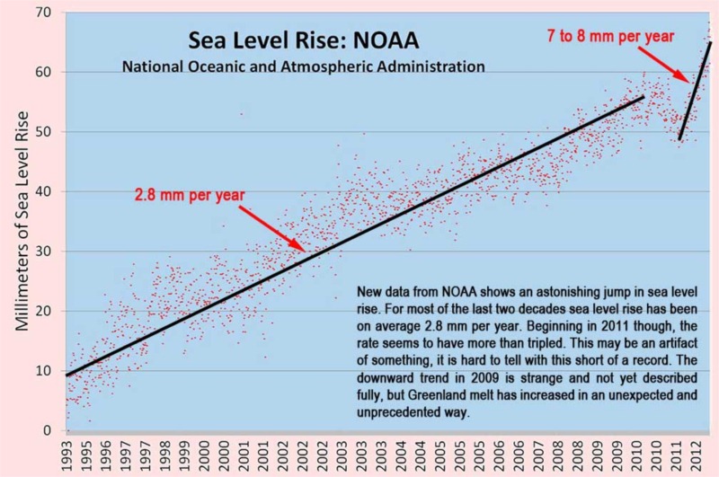
Stanford Scientists: Climate Change Occurring 10 Times Faster Than Any Time In Past 65 Million Years.
It's the rate of greenhouse gas release and subsequent warming that has
climate scientists so concerned. Here's a clip from a story at
desmogblog.com: "
With
scant media attention, climate scientists from Stanford University have
concluded that climate change is occurring 10 times faster than at any
time in the past 65 million years, and the current pace of change will
lead to a 5-6 degree (Celsius) spike by the end of this century. The findings come from a review of climate research by Noah Diffenbaugh, an associate professor of environmental Earth system science, and Chris Field, a professor of biology and of environmental Earth system science and the director of the Department of Global Ecology at the Carnegie Institution. Both scientists are senior fellows at the Stanford Woods Institute for the Environment. Their work is part of a special report on climate change in the current issue of Science..."
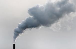
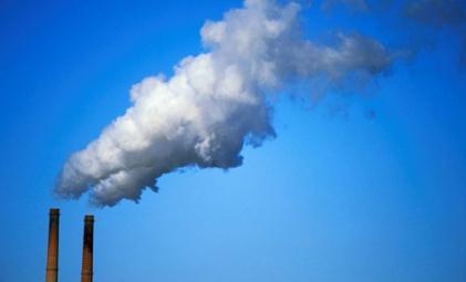
Refrigeration Could Cool Down The Cost of Carbon Capture and Storage. Here's a clip from an interesting article at
Gizmag: "
For years carbon capture and storage
(CCS) has been considered a costly but necessary step in reducing
emissions and protecting our environment. New research by Scandinavian
research organization Sintef has found that refrigeration technology may
reduce costs by up to 30 percent, increasing the potential for faster
implementation. “We were able to show that there are a number of
important potential improvements to be made in the process,” says Sintef
research scientist Kristin Jordal. “That said, cold CO2 capture turned
out to be one of the most promising technologies..."

No comments:
Post a Comment