45 F. high in the Twin Cities Monday.
64 F. average high on April 28.
81 F. high on April 28, 2013.
.69" rain fell yesterday as of 7 PM.
5.63" rain so far in April; 3.19" wetter than average, to date.
 Positive Spin
I've
taken all my meds and I'm determined to put a positive spin on today's
weather update. Hey, I'm in the mood for Minnesota Wild hockey! Bug
& humidity season has been delayed until further notice. No springy
weather to distract me from the stack of work in my weather-cubicle. And
farmers are breathing a collective sigh of relief. The drought is dead,
a million dollar rain event.
Pete Boulay at the State Climate
Office logged 5.45 inches of rain in the Twin Cities as of 1 PM
yesterday, making this the 4th wettest April on record, to date. The
wettest April? 7 inches fell in 2001. Let's go for a record and add a
few new lakes while we're at it!
Welcome to the coldest day of the
week. The same stalled storm pumping tropical moisture into Minnesota
is also yanking chilly air out of Canada. It may be cold enough for wet
snow to mix in with the rain at times today into tonight; maybe a slushy
inch or two on lawns and dazed robins north of the MSP metro area. Deep
breaths.
Another inch of rain falls before the sun peeks out
Friday - more showers arrive by Saturday night. Yes, the overall pattern
looks cool & wet.
Too chilly for tornadoes. Did I mention that?
Please wake me when spring arrives.
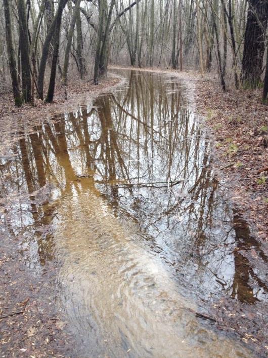
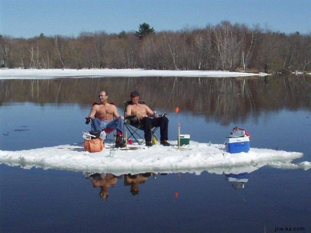
* Jon Howard took the photo above at the Elm Creek bike trail, which is on the border of Maple Grove & Champlin.
Ranking of April Precipitation from 1871 to 2014
Minneapolis-St Paul Area (MN)
Year Value Rank
2001 7.00" 1
2006 5.97" 2
1986 5.88" 3
2014 5.45" 4 (through 1pm April 28)
* thanks to Pete Boulay at the Minnesota Climatology Working Group for providing me with an update.
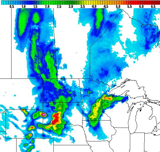
Slushy Possibilities.
My weather-whining muscles are exhausted. I'm beyond disgusted,
entering a realm of reluctant acceptance. Nothing we can do about it -
may as well go for weather-boasting-rights now. HAMweather maps (NOAA
NAM) show a potential for a couple inches of slushy accumulation over
central and southern Minnesota, an arc of 1-3" amounts possible from
near Duluth to St. Cloud, Willmar and Mankato by Wednesday morning.
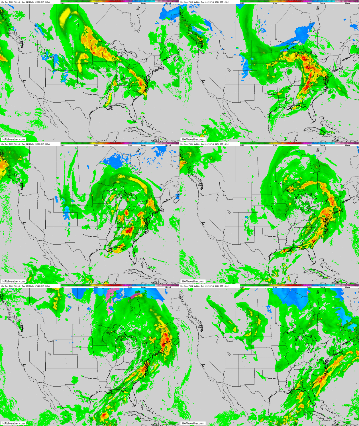
Retrograding Storm.
Future Radar shows a nearly stationary storm pinwheeling waves of
moisture across the Great Lakes into Minnesota, the atmosphere
marginally cold enough for wet snow to mix in at times today and
tonight. On the 29th day of April. Severe storms rumble across the Deep
South, the western third of the nation dry and mild. NAM model data:
HAMweather.
*
Flood Watch on the Mississippi
River downriver from Winona and La Crosse. With more heavy rain high
water levels may rise within 1 foot of flood stage in the coming days.
Details here.
Stunted Spring.
There's a chance we won't get out of the 30s today with a rainy, snowy,
sleety mix much of the day, sustained winds blowing at 20-25 mph. More
like February 29 than April 29. Rain Wednesday tapers to showers
Thursday. The sun peeks out Friday, and 50s will feel reasonable this
weekend, even a shot at 60F by Tuesday of next week. Circle your
calendar.
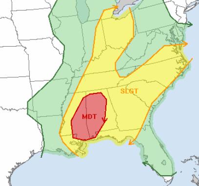 Severe Holding Pattern
.
The same stalled storm responsible for persistent rain (and some wet
snow) from the Great Lakes into the Midwest and Dakotas will spawn
another severe weather outbreak later today - a moderate risk of storms
over eastern Mississippi and much of Alabama implies another threat of
large, violent tornadoes - in pretty much the same area that was
impacted Monday. Source:
NOAA SPC.
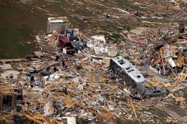
This Is What It Looks Like On The Ground In Arkansas Right Now.
Esquire
has an update, and a few Vine animated GIFS, one in particular that
shows how critical it can be to have a safe room on your property: "
A
string of tornados ripped through Arkansas, Iowa, and Oklahoma last
night, killing at least 18 people and destroying homes, cars, shopping
malls, and anything else in its wake. Here are five vines that capture
the devastation on the ground in Vilonia, Arkansas."
Photo credit: Danny Johnston, Associated Press.
* tornado survivors in Mayflower, Arkansas recount their terrifying ordeal, courtesy of
NBC News.
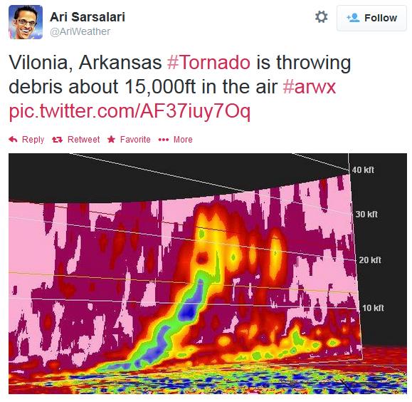
Debris At 15,000 Feet? Ari Sarsalari
tweeted out this Doppler-derived 3-D slice of the atmosphere above
Vilonia, Arkansas Sunday evening, apparently showing debris lofted
nearly 3 miles into the atmosphere by the massive tornado that pushed
north of Little Rock.
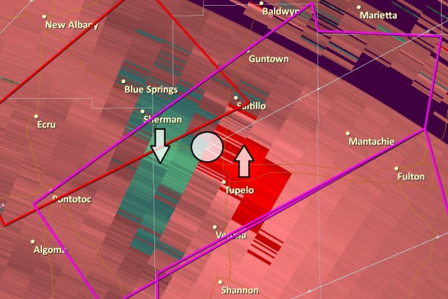
Tupelo Velocity Couplet.
I snapped this image yesterday (using GR3), a display of SRV, or Storm
Relative Velocity, showing 70-90 knots of winds going in either
direction around the north side of Tupelo, Mississippi. This is what
Doppler radar does, calculating the speed of rain drops and hailstones,
either toward or away from the radar site, and deriving areas of
spinning "supercell" mesocyclones, the rapidly rotating thunderstorms
most likely to spin up tornadoes.
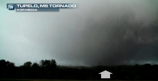
Wedge.
Here is a frame-grab from a video of the Tupelo tornado, a massive
"wedge tornado" that struck Monday afternoon, leaving behind extensive
damage and numerous injuries, but (almost miraculously) no reports of
fatalities as of late last night. Today's edition of
Climate Matters includes amazing video of the tornado, along with explanations of "debris balls" and "PDS Tornado Watches".
Extreme Tornado Swings: What Holds The Key.
Up until Sunday the USA was experiencing one of the quietest starts to
tornado season in recorded history. That said, after the events of the
last 48 hours it would be wildly premature to get too complacent about
tornado season. Here's a clip from
Climate Central: "...
But
while they can chart the tornado numbers, Carbin and his colleague
Harold Brooks have “no explanation” for what’s behind this wild swing in
tornado activity in just a handful of years. That hasn’t stopped them
from looking for one, though, including the possibility that climate
change is playing an unrecognized role. “We’ve been scratching our heads for awhile on what is driving this extreme sort of behavior,” Carbin said..."
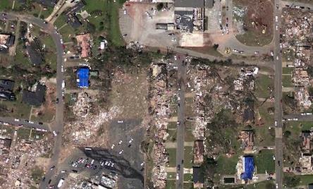
Image credit above: "
An
aerial photograph of the damage to Tuscaloosa, Alabama, in the vicinity
of the intersection of 15th St. E. and McFarland Blvd. E., wrought by
one of the tornadoes that struck the area on April 27, 2011." Credit: NOAA.
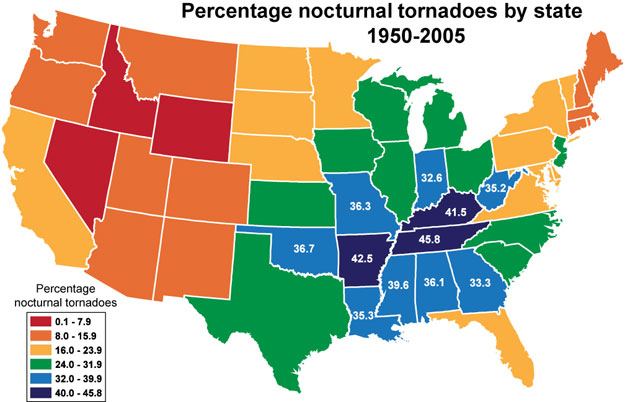
Nighttime Tornadoes.
The Ohio Valley and Mid South sees a high percentage of tornadoes at
night, which is problematic. Tornadoes are much harder to track by
spotters east of the Mississippi River (more hills, highway system not
on a grid) and at night spotters and chasers have to literally rely on
lightning strikes to confirm a tornado on the ground. Source: NOAA SPC.
Hurricane Center Improves Hurricane Intensity Predictions.
One of the biggest challenges in meteorology is predicting hurricane
intensity, days in advance. Historically forecasting hurricane tracks
have more skill than intensity. NOAA took more steps in the right
direction last year, as
SunSentinel reports - here's a clip: "...
Also
boosting intensity forecast accuracy, a computer model called the HWRF
showed significant improvement after being upgraded halfway through last
year's season. The main upgrade: Its resolution was increased, allowing
it to see more detail in the atmosphere and better analyze the
structure of storms. "The improvement in the HWRF was a big deal,"
Franklin said. "It gives us some hope for when we have a tougher year."
Meanwhile, the center's forecast track errors last year were
considerably larger than those in 2012 in almost every forecast period.
Franklin attributed that to so many systems being weak..."
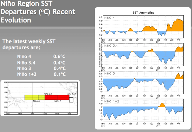
El Nino Risk Increases As Pacific Gets Warmer. Bloomberg has an update on the impending El Nino warm phase. At least for Minnesotans it can't come fast enough. Here's a clip: "
The odds are increasing that an El Nino weather system will form this year, portending drought for Australia and Asia and a warmer winter in the U.S. Northeast. The U.S. Climate Prediction Center
now says there’s a 65 percent chance the Pacific Ocean warming pattern
will develop after August. It put the odds at 52 percent last month. The
Australian Bureau of Meteorology, which expected neutral conditions at
the start of the year, says the phenomenon may start as soon as July.
The World Meteorological Organization of the United Nations sees an El Nino at midyear..."
* NOAA has all the ENSO/El Nino details you need to know
here.
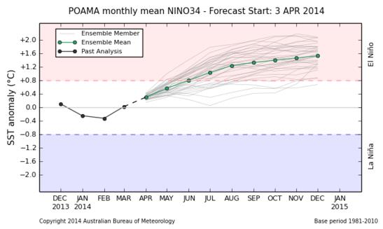
A Significant El Nino Brewing? Here's an excerpt from the
Australian Bureau of Meteorology that made me do a double-take: "
All international climate models
surveyed by the Bureau indicate that SSTs in the equatorial Pacific
Ocean are likely to continue to warm into winter. All models indicate
that the equatorial Pacific is likely to exceed El Niño thresholds by
the southern hemisphere spring, with six of seven models expecting this
to occur by July."
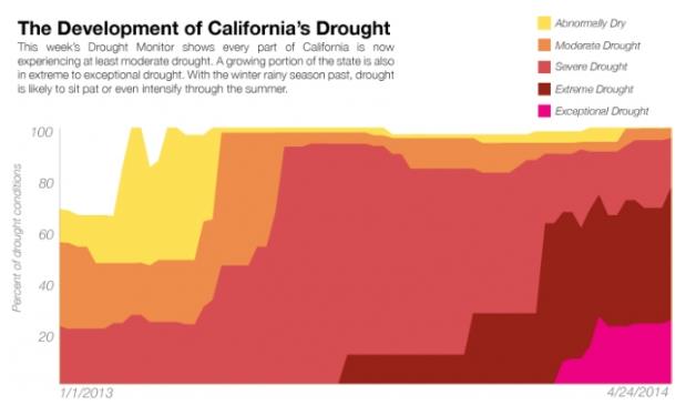
The Explosive Growth of California's Drought in 1 Chart.
Climate Central has the story - here's the introduction: "
It didn’t seem possible, but California's drought
just got worse. On Thursday, the U.S. Drought Monitor released new data
that show every single inch of the state is now experiencing some form
of drought. Since mid-March, a sliver of California on its southeastern
border was the lone drought holdout for the state. Even then, that
section of the state was still considered abnormally dry according to
the Drought Monitor. The section finally tipped into drought this week,
and for the first time in 15 year-history of the Drought Monitor, the entire state is now in drought..." (Image: U.S. Drought Monitor).
10 Breakthrough Technologies: 2014.
MIT Technology Review lists some of the innovations and technologies making news and disrupting established industries in 2014; here's a clip: "
Technology
news is full of incremental developments, but few of them are true
milestones. Here we’re citing 10 that are. These advances from the past
year all solve thorny problems or create powerful new ways of using
technology. They are breakthroughs that will matter for years to come."
Yes, It Appears Money Can Buy You Happiness.
Buying "stuff", material items, doesn't generate the long-lasting
happiness that a purchase of something that brings you closer to friends
or family can, research suggests. Here's an excerpt of a
Marketplace story that caught my eye: "...
Dr.
Ryan Howell, associate professor of psychology at San Francisco State
University, studies the connection between money and happiness. His
research tries to answer, "Can people spend their money to make
themselves happier?" And yes, he says, money can buy happiness. "Your
discretionary money, if it's spent on bringing you closer to your
friends and family [or] if it's spent building up psychological needs,
it can make you happy," Howell says. Experiential purchases such as
vacations, ball games, and concerts, offer a sense of happiness that, in
hindsight, people say they don't feel when purchasing material goods..."
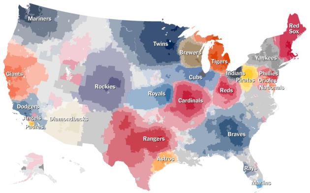
Up Close On Baseball's Borders.
The New York Times created a fascinating series of interactive maps that any baseball fan will absolutely want to explore. Here's an excerpt: "...
We’ve created two features to help readers explore the data. First is an interactive map of the United States
that allows you to explore not just the most popular team in your
neighborhood but also a table of the top teams for any ZIP code in the
country. Second, in the spirit of Mr. Rushin’s Munson-Nixon line, we've
generated 14 maps detailing baseball’s biggest rivalries, highlighting
the borders and offering suggested names for those lines..."
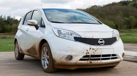
Here Comes The Self-Cleaning Car? Uh oh, my car wash investments may be in serious trouble, as reported at
Gizmag: "
Nissan
is currently testing out a prototype that it says could make car washes
a relic of the past. The test car benefits from a new nano-paint
treatment that repels dirt and grime. The automaker is putting the car
through the dirty wringer to see how well it holds up in the real world..."
TODAY: WIndy and raw. Rain mixed with snow. Slush north. WInds: NE 20. High: 38
TUESDAY NIGHT: Rain/snow mix, slushy lawns and fields, especially north of MSP. Low: 35
WEDNESDAY: Slushy lawns early? More rain likely. High: 41
THURSDAY: Showers taper. Sunscreen optional. Wake-up: 37. High: 43
FRIDAY: Intervals of sun, better. Wake-up: 36. High: 55
SATURDAY: Some sun, showers at night. Wake-up: 39. High: 56
SUNDAY: Damp start, then slow clearing. Wake-up: 42. High: 55
MONDAY: Unsettled, risk of showers. Wake-up: 39. High: 57
Climate Stories...
Will Global Warming Produce More Tornadoes?
The (scientific) jury is still out; the prevailing wisdom has been that
any increase in instability/CAPE would be offset by less wind shear, as
northern latitudes warm faster than lower latitudes. But recent
research is calling everything into question. Here's an excerpt of a
story from Chris Mooney at
Mother Jones: "...
That conclusion fell into question late last year, though, with a paper
by Diffenbaugh and two colleagues in the Proceedings of the National
Academy of Sciences. Using a suite of the most state-of-the-art climate
models, the researchers found, once again, that wind shear decreases
under global warming. However, they also found that that didn't really
matter, because the number of days with both high CAPE and high shear
nonetheless increased. "We find that in fact, at the monthly or seasonal
scale, that decrease [in shear] does occur over the US," Diffenbaugh
says, "but it's concentrated in these days with very low CAPE." That
means that the net number of days with high CAPE and high shear was
still projected to increase in the future..."
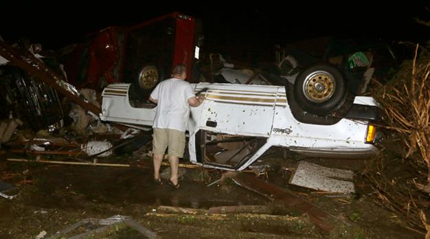
Photo credit above: "
An automobile dealer surveys the tornado damage to one of his trucks in Mayflower, Arkansas, on Sunday." Danny Johnston/AP Photo.
Climate Change, El Nino, Cold Winters, and California's Drought. Does
climate volatility have a role in the California drought, or the odd
and persistent permutations that parked the Polar Vortex over the USA
for the better part of 3 months? Here's a clip from a story at
Ars Technica: "...
The
detours of the jet stream were large, and they were persistent. The
northward-bending “ridge” shielded the West Coast from moisture-bearing
weather that would normally water the Californian landscape and restock
the supply of mountain snow that provides meltwater over the dry summer.
Many wondered if climate change could be partly responsible—a question
that gets asked about every extreme now. It is, as always, a difficult
question to answer, considering the inherent and substantial variability
of weather. However, it’s also plainly true that average atmospheric
conditions have changed over the past century. The hard part is teasing
out the contribution of those changing conditions to specific weather
events..."
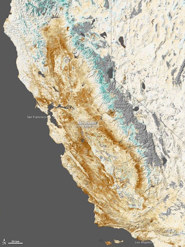
Graphic credit above: "
Vegetation
growth for late January 2014. Brown is below average; green is above
average. The green areas in the Sierra Nevada mountains would normally
be covered in snow at this time of year".
NASA Earth Observatory/Jesse Allen
The Koch Attack On Solar Energy. Yes, by all means let's tax the sun. Because it's free and you can't put a meter on it. Here's a clip from a recent
New York Times Op-Ed: "
At
long last, the Koch brothers and their conservative allies in state
government have found a new tax they can support. Naturally it’s a tax
on something the country needs: solar energy panels. For the last few
months, the Kochs and other big polluters have been spending heavily to
fight incentives for renewable energy, which have been adopted by most
states. They particularly dislike state laws that allow homeowners with
solar panels to sell power they don’t need back to electric utilities.
So they’ve been pushing legislatures to impose a surtax on this
increasingly popular practice, hoping to make installing solar panels on
houses less attractive..."
Climate Change: How To Talk About Bad News. More data, more evidence doesn't always convince skeptics, as pointed out in this article at
marketplace.org; here's an excerpt: "...
Focus on the benefits,” Webber says. “Scare
campaigns work extremely well when there’s a simple thing you can do to
remove the danger. But if it takes protracted action, over time, nobody
wants to feel bad for that length of time. People just tune out.”
The real challenge, however, may be to talk about climate change in
ways that don’t push people’s cultural and political buttons. Dan Kahan’s research shows that the way people view climate change is closely tied to their values. People “aggressively filter” information that doesn’t conform to their worldview. “And
remarkably the more proficient somebody is at making sense of empirical
data," he says, "the more pronounced this tendency is going to...”
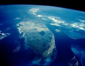
Water In Our Shoes. Here's an excerpt of an Op-Ed from
The Miami Herald,
at ground zero when it comes to rising sea level. South Florida is
truly on the front lines of a more volatile, rapidly changing climate: "
For
South Floridians, the topics of climate change and rising sea levels
are no longer to be dismissed as tree-hugger mumbo-jumbo. Pause next
time you hear that parts of Miami Beach or the intersection of A1A and
Las Olas Boulevard have flooded because of … high tides?
Let the light go off atop your head: It’s science, stupid. On Tuesday,
Florida Democratic U.S. Sen. Bill Nelson brought illumination to Miami
Beach — Ground Zero for our unique coastal battle with Mother Nature..." (Image: NASA).
What Does Today Owe Tomorrow? Justin Gillis at
The New York Times
examines the issue of legacy, our collective responsibilities for
future generations. How do economists assess the risk and what should be
done to limit impact? Here's an excerpt: "...
Their analyses tend to
suggest that, because we have dawdled so long, the economic damage from
climate change is going to be substantial, no matter what we do from
here. They also generally find that this damage is likely to be dwarfed
by bigger economic trends unrelated to climate, like the evolution of
technology and shifts in population. Despite those findings, the typical
economic analysis suggests that it is still worth trying to limit
climate change — in other words, not only can the damage be reduced
somewhat, but the future benefits of doing so outweigh the current costs..."
"Green Is Resilience". An article at emissourian.com caught my eye - climate scientists talking to very conservative audiences in
central Missouri. Here's an excerpt: "...
I
would suggest my free market colleagues, especially conservatives, who
think that climate change is a bunch of hooey, the Chinese do not. They
plan on eating our lunch this next century. They plan on innovating
around the problem and selling to us and the rest of the world the
technology that will lead the 21st century. “We may press the pause button in America trying to figure out what to do, but China is pressing the fast forward button.”
Climate Change Survival: Companies Need Courage...And New Metrics.
The smart companies will go on offense and not wait to make their
facilities and processes more resilient and storm-proof. Here's an
excerpt from
The Guardian: "...
Conservative,
in this case, essentially means conserving resources to ensure
long-term security. In my brother's case, from the time he became aware
of the coming crisis, there was no "business as usual" in anything he
did: he took emergency measures to protect his company, his workers and
his future. And it worked. Many companies are looking beyond
sustainability to survivability in their radical approaches to
environmental issues. KPMG
calculated that the environmental degradation caused by the world's
3,000 largest public companies totaled $2.15tn in 2008. This estimate
undoubtedly antagonized many of the company's biggest clients..." (Image: Shutterstock).
Read more here: http://www.miamiherald.com/2014/04/23/4076473/water-in-our-shoes.html#storylink=cpy
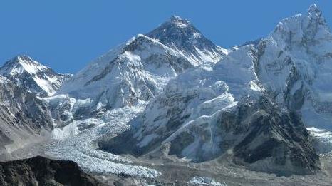
How Climate Change Makes Everest An Even Deadlier Game. Grist has a few details and findings I wasn't aware of; here's an excerpt: "...
On
Everest, it’s as simple as this: Snow and ice are the glue that holds
the route up the south col together. When that glue melts, things
literally start to fall apart. And while scientists say global
temperatures have risen .75 degrees C (1.4 degrees F) in the last
century, studies show temperatures in the Himalaya have risen at a rate three times that.
The avalanche swept through the part of the route that is most prone to
temperature-induced deterioration: the Khumbu Icefall. Even within a
season on Everest, the route up the icefall is constantly being
rearranged, as summer’s approach widens crevasses and breaks off big
columns of ice called seracs..." (Image above: Wikimedia Commons).
"
The Year Climate Change Closed Everest". The Atlantic has
the story.
 Positive Spin








No comments:
Post a Comment