Wetsuit Required
By Todd Nelson
By Todd Nelson
I'm feeling slightly guilty right now... while enjoying some warmer weather in sunny Arizona this week, I realize that the weather back home will be less than ideal. In fact, weather conditions will be downright U-G-L-Y!
It's not everyday, you'll get a "cut-off" low pressure system that sits and spins over the same area day after day. We'll be on the northern end of a powerful Pacific storm that has matured in the midsection of the nation. Several rounds of severe storms and tornadoes ongoing in the Mississippi River Valley will continue through the early week time frame. As the conveyor belt of moisture continues to draw moisture north, folks in the Midwest will be on the receiving end of this nonsense.
Cool and showery weather is in the forecast every day this week. Some across the far north may even see a few mixed showers during the overnight hours, but most will see continued wet weather through the end of the week.
I guess I realize now why my parents left Minnesota - it was cutting into my Dad's golf game! However, they becomes wimps; my Mom was dressed like a Winter Olympian on Saturday with highs in the mid 70s.. and she was born MN!
==========================
SUNDAY NIGHT: Wet, rumble of thunder. Low: 43. Winds: E 20-30.
MONDAY: Sideways rain at times. High: 48. Winds: E 10-20.
MONDAY NIGHT: Still breezy with scattered showers. Low: 37. Winds: NE 10-20
TUESDAY: May Day rain, mixed showers up north. High: 45. Winds: NNE 10-15
WEDNESDAY: Puddles continue to grow. Wake-up: 37. High: 48
THURSDAY: Breezy with lighter rain/sprinkles. Wake-up: 39. High: 50
FRIDAY: Mostly cloudy, spotty sprinkles. Wake-up: 38. High: 52.
SATURDAY: Peeks of sun, few PM showers. Wake-up: 40. High: 56.
SUNDAY: Soggy early, more PM sun and warmer. Wake-up: 43. High: 58.
==========================
This Day in Weather History
April 28th
1989: Baseball-sized hail pummels Pequot Lakes.
=========================
Sunrise/Sunset Times
April 28th
SUNRISE 607 AM
SUNSET 814 PM
======================
MSP Averages for April 28th
Average High: 64
Average Low: 43
=======================
Moon Phase for April 28th at Midnight
1 Day Before New Moon

=======================
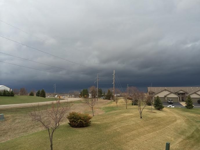
Soggy Sunday
Thanks to Aaron Weidner for the picture below from Otsego, MN - This was prior to the round of evening thunderstorms.
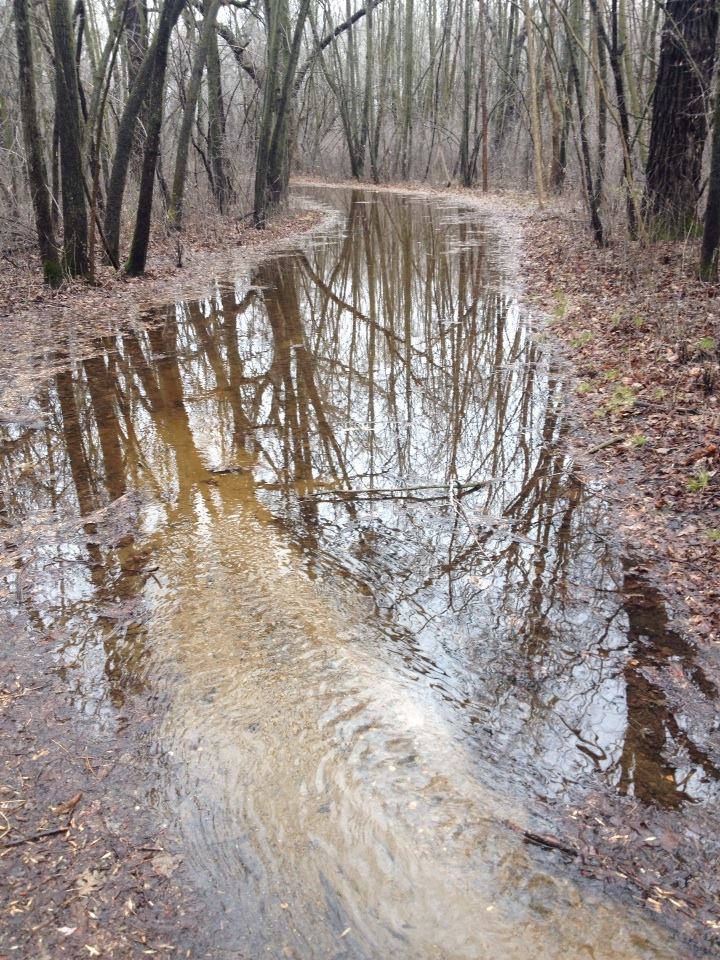
Jon Howard snapped this picture from the Elm Creek Park Reserve on Sunday, he said the trails were swamped.
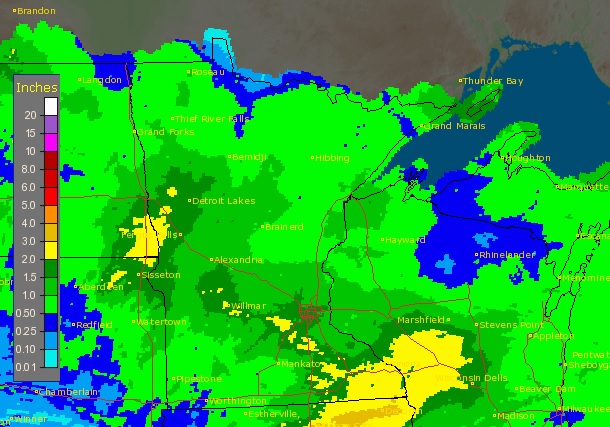
Precipitation Past 7 Days
Radar estimated rainfall over the past 7 days suggests that widespread 1" to 2" of rain has come down along the I-94 corridor, with more precipitation to come.
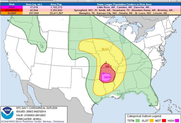
Sunday's HIGH RISK
The HIGH RISK on Sunday was one of the highest severe risks of the season thus far.
Stormy Sunday
Thanks to @Ryan_Graves33 for this tornado picture near Galena, KS on Sunday

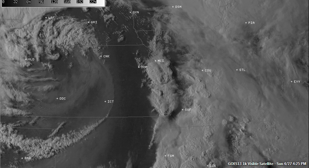
Satellite Sunday
The satellite on Sunday looked quite impressive along a dryline that was setup on the KS and MO border. Thunderstorms at this point were tornado warned
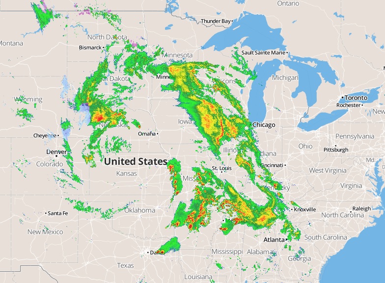
Radar Sunday
This is what the radar looked like on Sunday as the storms were erupting across the Plains
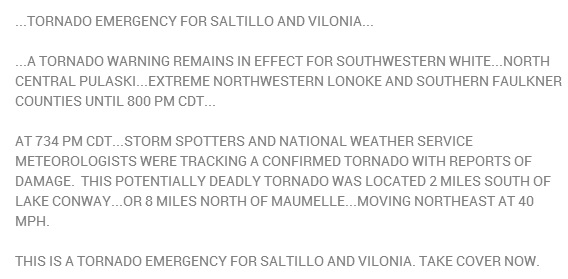
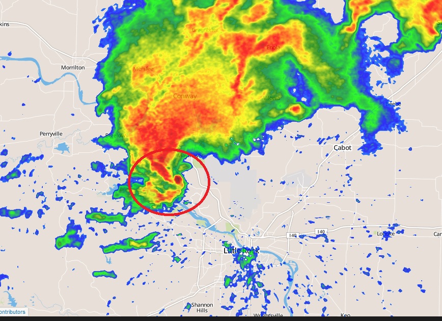
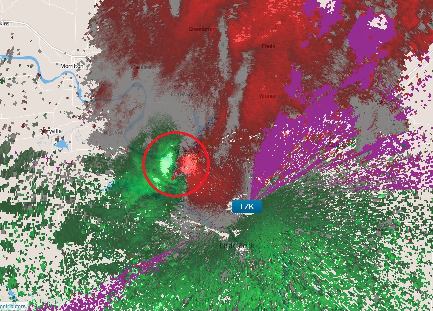
Impressive Tornado on Radar Near Little Rock
Here was one of the tornadoes via radar on Sunday evening just NW of downtown Little Rock, AR!! In fact, the tornado warning that was in effect for this particular storm was a TORNADO EMERGENCY... this is what the tornado emergency text looked like!
Severe Threat Continues
Look at how slow the storm system is... the loop below from AM Monday to PM Tuesday, the center of circulation moves east about one state; from Nebraska to Iowa. The waterlogged storm system will still be kicking out heavy rain and severe weather through the middle part of the week.
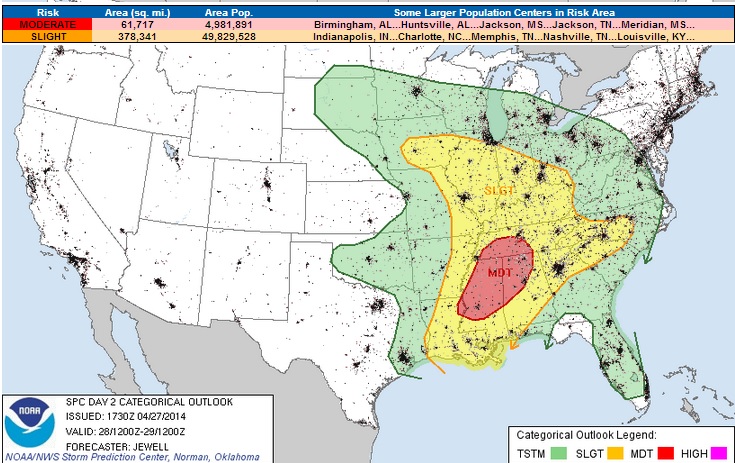
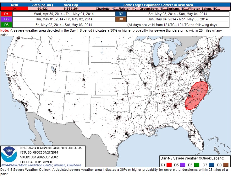
Severe Threat Monday
...LOWER MS VALLEY EWD INTO NRN AL AND MIDDLE TN... WHILE THE PREVIOUS DAYS CONVECTION WILL LIKELY PLAY A ROLE IN DELINEATING THE PRECISE THREAT CORRIDOR...A SW-NE ORIENTED ZONE OF TRAINING SEVERE THUNDERSTORMS IS LIKELY FROM NERN LA ACROSS MS AND INTO NRN AL AND MIDDLE TN. THE STORMS WILL EITHER BE TIED TO THE COLD FRONT...OR AN OUTFLOW BOUNDARY WHICH COULD SPREAD OUT AHEAD OF THE MAIN SLOW MOVING FRONT. REGARDLESS...A VERY MOIST AND UNSTABLE AIR MASS WILL RESIDE AHEAD OF THE COLD FRONT...WITH SHEAR PROFILES QUITE FAVORABLE FOR SUPERCELLS AND TORNADOES. A LONG UPDRAFT RESIDENCE TIME IN THE UNSTABLE AND HIGHLY SHEARED ENVIRONMENT...AS WELL AS RELATIVELY STEEP MIDLEVEL LAPSE RATES SUGGEST STRONG TORNADOES WILL BE POSSIBLE. VERY LARGE HAIL WILL ALSO OCCUR AS WELL AS POTENTIAL FLOODING. THE MOST SIGNIFICANT TORNADO THREAT IS EXPECTED ACROSS MS.
Severe Threat Tuesday
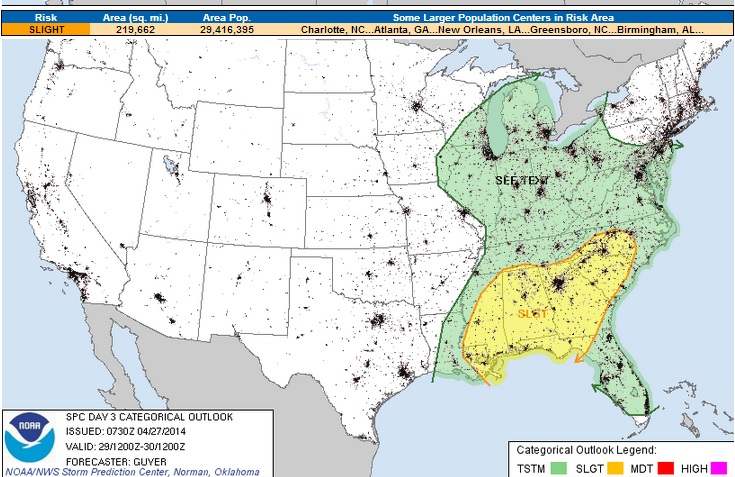
Severe Threat Wednesday
Slow Moving Storm Continues
Here's another view of the storm as it slowly moves east. The loop shows the storm from PM Sunday to AM Thursday. Note that there isn't much movement from west to east. Also, the moisture conveyor belt continues to send moisture north/northwest through this entire time!
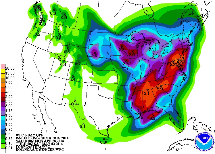
5 day Precipitation
According to NOAA's HPC, the 5 day precipitation forecast suggests quite a bit of precipitation yet over the eastern half of the country along with the Midwest. It's a waterlogged storm that doesn't seem to want to quit. Flooding is going to be a real Likelihood with as much rain as some could see through the end of the week.
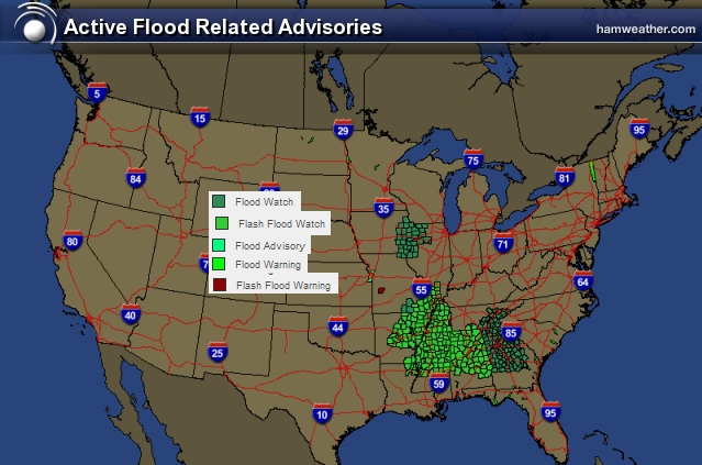
Flood Concerns
* FROM MONDAY EVENING THROUGH WEDNESDAY MORNING * RAINFALL AMOUNTS OF NEAR 4 INCHES WITH LOCALLY UP TO 6 INCHES ARE POSSIBLE ACROSS PARTS OF THE CENTRAL AND SOUTHERN TENNESSEE VALLEY AND PLATEAU
Thanks for checking in and have a great week ahead. Don't forget to follow me on Twitter @TNelsonWNTV

شركات تخزين اثاث بالرياض
ReplyDeleteشركة نقل اثاث في الرياض
شركة رش مبيدات بالرياض
شركة تنظيف خزانات بالرياض
شركات عزل اسطح بالرياض
شركة تنظيف مسابح بالرياض
شركة تنظيف منازل بالرياض
شركة تنظيف شقق بالرياض
شركة تنظيف مجالس بالرياض
شركة كشف تسربات المياه بالرياض
شركة تنظيف موكيت بالرياض
شركة تسليك مجارى بالرياض