By Todd Nelson
Ahh... that's more like it! FINALLY, a weekend that reminds me why I live in Minnesota! I was starting to question why I lived north of the '540 line' - you weather weenies will get that.
Memorial Weekend has always been a weekend that I've been able to enjoy spending time with family up north. I can remember several times in years past trolling for walleyes while it was sleeting or snowing. So all things considered, this is going to be a wonderful weekend, enjoy and thank you to all the service men and women for serving our great country!
A slow moving storm system across the southwestern U.S. has allowed the weather in the
central U.S. to stall a bit. Timing couldn't have been more perfect for us as temperatures will warm into the 70s and 80s across the state for the next several days.
Weather conditions sour a bit for the second half of the holiday weekend as showers and thunderstorm chances look to increase. We won't see any all days rain, so you should still be able to fit in a BBQ with family and friends, but you may also have to dodge a few PM thundershowers.
If you can believe it, temps may flirt with 80 through much of next week! You betcha!
=======================
FRIDAY NIGHT: Mostly clear and pleasant. Low: 54
SATURDAY: Driest day of the holiday weekend. Partly sunny with a PM thunder risk across northern
MN. Winds: SSE 10-15. High: near 80
SATURDAY NIGHT: Clouds increase, risk of a shower late northern MN. Low: 60
SUNDAY: Humid & unsettled with more clouds than sun - risk of a T-storm. Winds: S 15. High: 81
MEMORIAL DAY: Some hazy sun. More T-storms, generally southern MN. Wake-up: 65. High: 82
TUESDAY: Sticky sun. PM storms southern MN. Wake-up: 60. High: 80
WEDNESDAY: Very warm. Feels like summer. Wake-up: 59. High: 81
THURSDAY: Steamy sun, late-day T-storm? Wake-up: 62. High: 82.
FRIDAY: Warm streak continues. Wake-up: 60. High: 81.
=======================
This Day in Weather History
May 24th
1925: After seeing a high of 99 degrees two days earlier, the Twin Cities picked up a tenth (.10) of an inch of snow.
1908: Tornadoes hit the counties of Martin and Blue Earth.
======================
MSP Averages for May 24th
Average High: 72
Average Low: 51
======================
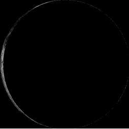
Moon Phase for May 24th at Midnight
3.5 Days Before New Moon
========================
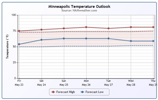
MSP Temp Trend
WOW! I haven't seen a string of temperatures for Minneapolis like this in a long time! Despite a few afternoon/evening thunderstorm chances, temperatures will remain quite mild through next week! Enjoy!!
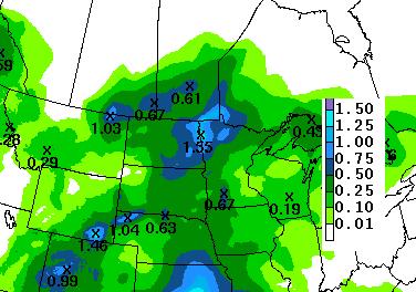
Weekend Rainfall
No question, the second half of the weekend looks more unsettled than the start of the weekend. Rainfall looks 'heavier' across the western part of the state, but thundershowers could produce heavier pockets of rain closer to home.
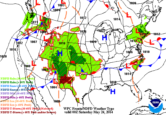
Memorial Weekend Forecast
Our high pressure system begins to shift east over the holiday weekend, bringing unsettled weather back to the Midwest.
Atlantic Hurricane Forecast
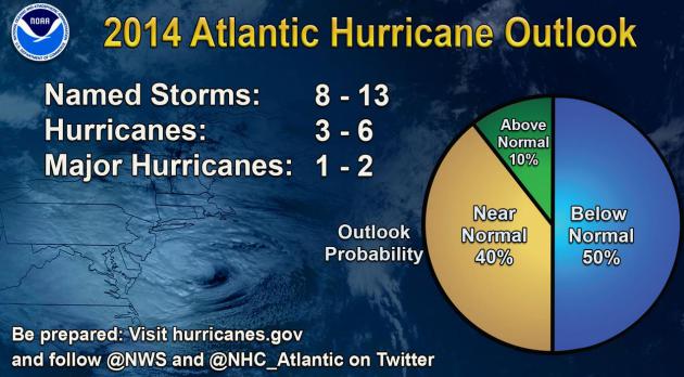
NOAA Predicts Near-Normal or Below-Normal 2014 Hurricane Season. A big factor to consider is El Nino, which usually increases wind shear over the tropics, reducing the potential for tropical development somewhat. Then again, all it takes is one. Here's an excerpt of Thursday's official NOAA NHC hurricane prediction for the upcoming season: "...The main driver of this year’s outlook is the anticipated development of El Niño this summer. El Niño causes stronger wind shear, which reduces the number and intensity of tropical storms and hurricanes. El Niño can also strengthen the trade winds and increase the atmospheric stability across the tropical Atlantic, making it more difficult for cloud systems coming off of Africa to intensify into tropical storms. The outlook calls for a 50 percent chance of a below-normal season, a 40 percent chance of a near-normal season, and only a 10 percent chance of an above-normal season. For the six-month hurricane season, which begins June 1, NOAA predicts a 70 percent likelihood of 8 to 13 named storms (winds of 39 mph or higher), of which 3 to 6 could become hurricanes (winds of 74 mph or higher), including 1 to 2 major hurricanes (Category 3, 4 or 5; winds of 111 mph or higher)..."
* The Orlando Sentinel reminds us that it's not the sheer number of hurricanes and tropical storms that matter - but where they go, and how intense they become before landfall.
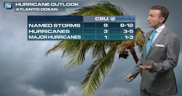
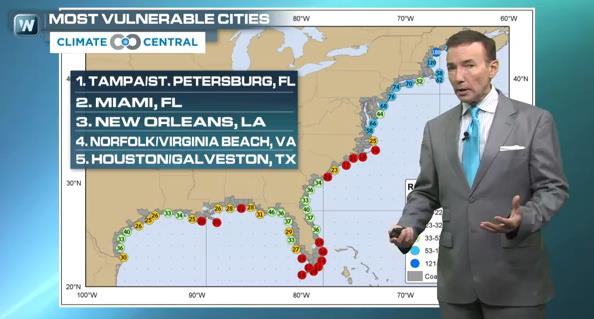
More Background on NOAA's 2014 Hurricane Outlook. El Nino is a factor in this year's prediction of fewer hurricanes, along with cooler water in the Atlantic. But there is lingering concern about complacency. All it takes is one hurricane, coming at the wrong time and place, to cause serious problems. In today's Climate Matters segments we look at the Hurricane Outlook from NOAA, Colorado State and WeatherBug, and how rising seas and land subsidence are leaving some metro areas more vulnerable to tropical storm surge flooding than others.
GONE FISHING
Sorry for such a short blog today... but I'm busy fishing!!

Thanks for checking in and have a great holiday weekend! Don't forget to follow me on Twitter @TNelsonWNTV

No comments:
Post a Comment