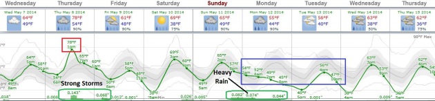
65 F. high in the Twin Cities Tuesday.
67 F. average high on May 6.
76 F. high on May 6, 2013.
Slight severe risk today, again Thursday.
.47" rain predicted for MSP by Friday morning.
"
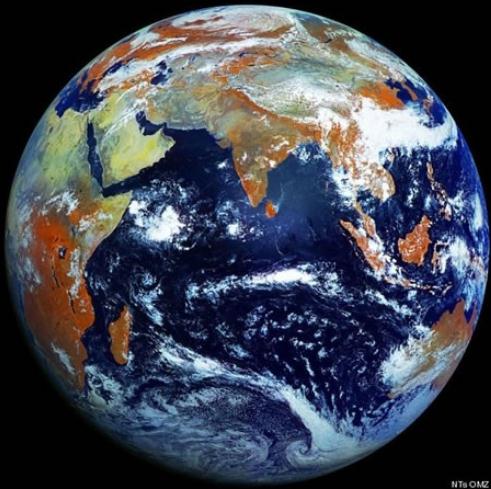
Extreme
heat, heavy downpours, and flooding will affect infrastructure, health,
agriculture, forestry, transportation, air and water quality, and more.
Climate change will also exacerbate a range of risks to the Great Lakes." - from the latest National Climate Assessment, details below.
From Theory to Reality
You
don't predict the weather, you live it. It's the rough equivalent of
getting undressed - in public - every day. Over time you develop an
appreciation for the rhythm of weather patterns; the natural ebb and
flow of the elements.
In the late 90s I noticed changes in
Minnesota's weather: more summer downpours & humidity, erratic
winters and stupefying examples of whiplash - going from one extreme to
another, in an impossibly short period of time. I started talking about
it at The Star Tribune & WCCO-TV. Some found the message
threatening, and pushed back hard. I doubt it helped my on- air career,
but reporting observations and trends shouldn't be a popularity contest.
The
data is the data and the science is clear: our climate is changing.
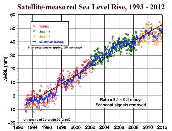
Symptoms are already showing up in our weather; sea levels are rising.
More details on the latest National Climate Assessment below.
Storms
brush southern Minnesota this morning; a better chance of strong to
severe storms Thursday afternoon as readings spike into the upper 70s.
Yes,
it would be nice to have a warm front without the sirens singing in
unison. We salvage some sun Saturday before the next round of stormy
weather arrives early next week.
* image above: Nicolle Rager Fuller, National Science Foundation.
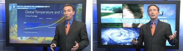
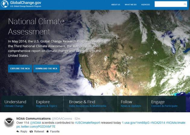
Understanding The Latest National Climate Assessment.
In today's editions of Climate Matters I take a look at the 4th
National Climate Assessment, which doesn't pull many punches. Climate
change has gone from theory to reality, and symptoms of
increased climate volatility are showing up in increasingly extreme episodes of violent weather and rising sea levels.
Summer rains are falling with greater intensity,
especially from New England to the Great Lakes and Midwest, but dry
areas over the western half of the USA are getting drier. Welcome to the
United States, the Super Bowl of Weather, and the World Series of
Weather Whiplash.
Mostly
Springlike. Although we'll experience a minor relapse early next week
with a couple days in the 50s, 60s are the rule looking out the next 8
days; 70s likely Thursday, again Sunday before cooling down. I still
don't see any hot fronts brewing for Minnesota and the Upper Midwest.
Strong to severe storms today and Thursday give rise to a few more
T-storms on Mother's Day; a soaking rain possible Monday as a southern
storm tracks just to our east. Graphic: Weatherspark.
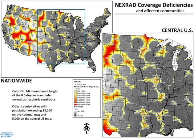
NEXRAD Doppler Radar "Holes".
NEXRAD radar technology is a huge step forward, but there's no question
that coverage, and the ability to see extreme weather, including
tornadoes, is degraded with distance. Because the Earth is curved
(really!) Doppler radar routinely overshoots the ground the farther away
you are from the radar site. By the time you're 100-200 miles away the
beam is 2-4 miles above the ground - it's impossible to detect weather
signatures (or tornadic rotation) in the lowest few thousand feet of the
atmosphere, which is problematic when tracking severe weather and
attempting to issue credible warnings.
Iowa State
has an interesting graphic that shows where these coverage "holes" are.
In Minnesota they include Morris, Wadena, Brainerd, Detroit Lakes and
Alexandria. The problem is considerably worse over much of the western
USA.
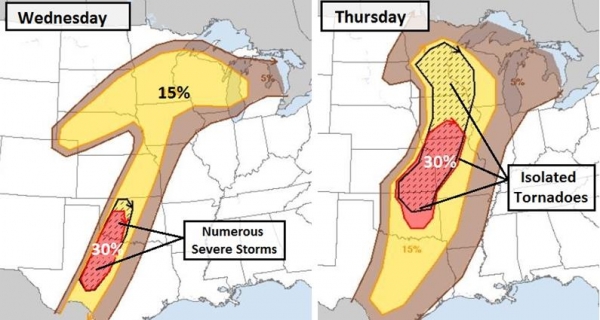
Alerts Broadcaster Briefing: Issued Tuesday evening, May 6, 2014.
* Growing severe storm risk along the I-35 corridor Wednesday and Thursday.
* Wednesday risk focused from
Oklahoma City and
Wichita Falls to
Abilene and
San Angelo, Texas - a few large tornadoes are likely.
* Thursday threat shifts farther north, including
Tulsa,
Wichita,
Kansas City and
Des Moines, where an afternoon squall line may spark a few large, violent tornadoes. Isolated tornadoes are possible as far north as the
Twin Cities of Minnesota and western Wisconsin.
*
Extreme fire danger lingers over the southern Plains: combination of intense heat, strong winds and low humidity increases fire risk.
Evolving Severe Risk.
NOAA SPC has issued a slight risk across a narrow sector of the central
USA Wednesday and Thursday. There is a nearly 1 in 3 chance of
"significant severe weather" (EF-2+ tornado and 2"+ hail) within 25
miles of any location from central Texas into western Oklahoma
Wednesday. On Thursday that same level of (significant) severe storm
risk shifts into Wichita, Kansas City and Des Moines, where a few large,
violent tornadoes can't be ruled out.
* I expect severe storm, possibly tornado watches, to be issued as far north as Minnesota and Wisconsin by Thursday afternoon.
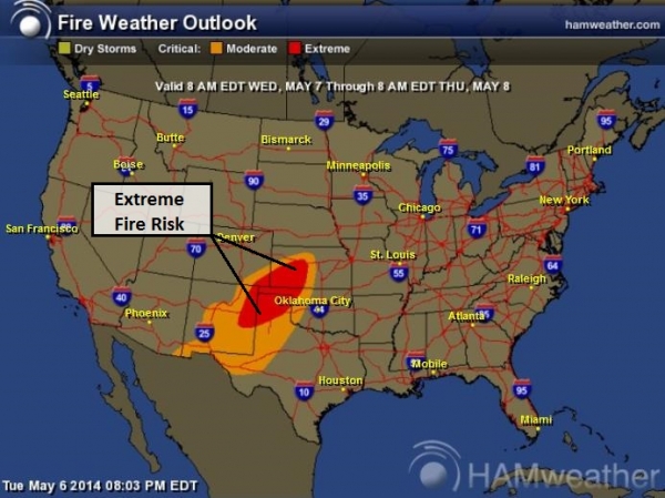
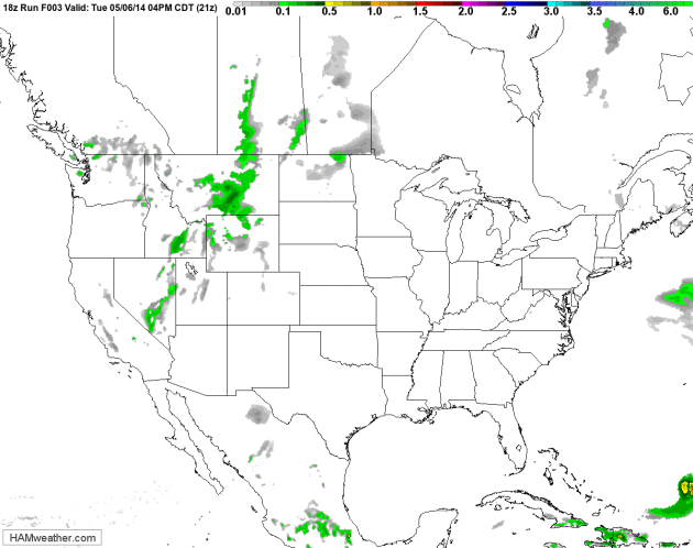
Thursday TPI.
Alerts Broadcaster's proprietary Tornado Potential Index shows an
enhanced risk of severe storms, including isolated tornadoes, from near
St. Cloud to the
Twin Cities, as far east as
Green Bay by late afternoon Thursday. Graphic: HAMweather.
Extreme Fire Danger.
The same atmospheric conditions that sparked large fires north of
Oklahoma City Monday linger into Wednesday over the southern Plains. The
highest threat includes southwestern Kansas, the Oklahoma and Texas
Panhandles and northeastern New Mexico.
Summary:
after a couple of relatively quiet days after last week's major tornado
outbreak and record floods from Pensacola to the Delaware Valley, we're
heading into a more volatile weather pattern once again. Although
probably not as severe or widespread as last week, tornadoes are likely,
and a few may be large, long-track twisters capable of extensive damage
and injury. Flash flooding is likely with some of these storms pushing
toward the Mississippi Valley, while the risk of wildfires is unusually
high for the southern Plains into midweek, symptomatic of a deepening
drought. We'll keep you posted.
Paul Douglas - Senior Meteorologist - Alerts Broadcaster
Ripe For Severe Storms.
NOAA's 12 km NAM model shows strong to severe storms spinning up along a
slow-moving frontal system later today into Friday; the atmosphere
still cold enough for a few inches of wet snow over the western Dakotas.
Good grief - what a spring. Animation: NOAA and HAMweather.
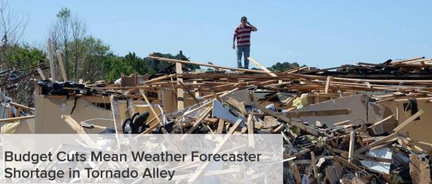
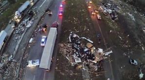
Budget Cuts Mean Weather Forecaster Shortage in Tornado Alley.
NBC News has the story - here's the introduction: "
With tornado season underway the National Weather Service is short nearly 200 meteorologists, including vacancies in Tornado Alley and at the office responsible for predicting tornadoes,
according to documents obtained by NBC News. NBC owned and operated
station KXAS in Dallas/Ft. Worth has acquired union documents showing as
many as 500 vacancies at NWS offices around the country, including
nearly 200 unfilled jobs for front-line meteorologists...."
Read a full report at NBC 5 Dallas-Fort Worth
Weather Quiz: Which state has the highest density of tornado touch downs?
Oklahoma Texas Kansas Florida
Scroll down for the answer (which is definitely non-obvious).
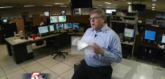
Trained Weather Spotters Play Critical Role Across Minnesota. KSTP and
KAAL-TV
have a video on the critical importance of trained weather spotters and
the role they play, especially spotting and tracking severe weather;
here's a clip: "...
Spotters report to the Skywarn network, and the
information is quickly passed to the news media and public safety
officials to give people in the area of a dangerous storm as much time
as possible to get to shelter. Krause says spotters play a major role in
that process, "The weather spotters in the field are the ones that
confirm that tornado is there, and when you have confirmed tornados,
people are much more likely to get to shelter..."
Will We Ever....Control The Weather? The
short answer is no, at least not on a massive scale. On certain rare
occasions we can tip the weather in a specific direction, but the amount
of energy required to nudge the atmosphere on a large (synoptic) scale
is staggering.
The BBC has an interesting read, including this response to the notion of hurricane control: "..
.For
Hugh Willoughby at the Florida International University in Miami,
though, plans to tame hurricanes are pie in the sky. “Nearly all of the
schemes are utter nonsense,” he says. Draining the energy out of a
hurricane is a tall order, because the storm systems are a lot more
powerful than people realise. “They release heat at a rate equivalent to
a 10-megaton nuclear bomb exploding every 20 minutes.” Using oil to nip
hurricanes in the bud before they form won’t work either, he says,
because it’s impossible to predict which of the many storm disturbances
seen in the ocean will actually become a hurricane..."
Quiz Answer: Florida. "
When
it comes to counting tornadoes, the National Oceanic and Atmospheric
Administration tracks every single one, big or small, enormous damage or
none. By that count, Florida (and not its blustery neighbors on the
Great Plains like Oklahoma) has the highest density of tornado activity
in the United States. The state averages nearly 10 tornadoes per year,
per 10,000 square miles (which puts the total density of tornadoes in
the state at nearly twice the levels found in places like Oklahoma and
Texas)."
Quiz courtesy of
howtogeek.com.
MSU Professor Develops Tornado Detector Prototype.
OzarksFirst.com has the story of an invention born out of necessity, and one very close call. Here's an excerpt: "...
He
developed an indoor alarm that rings when the pressure change over a
certain length of time exceeds a certain threshold. "This is a circuit
board. One example of about a hundred that I have," says Dr. Redd as he
holds his tornado alarm. There is a small piece of the device that
detects barometric pressure change. Based on this, the device can alert
you of an approaching tornado. The device has two stages of alarm. The
first signals people to get ready to take shelter, giving a lead time
of about three minutes. The second signals people to take shelter
immediately, indicating a tornado is about 30 seconds to a minute away..."
This Is What Comes After Search.
Context (and geographic) based search - that anticipates your wants and
needs? Here's a clip from about a fascinating new app at
Quartz: "
The
average person with an Android smartphone is using it to search the
web, from a browser, only 1.25 times per day, says Roi Carthy, head of
special projects at Tel Aviv-based mobile startup Everything.Me.
That isn’t just bad news for Google, which still relies on ads placed
along search results for the bulk of its revenue—it also signals a
gigantic, fundamental shift in how people interact with the web. It’s a
shift upon which fortunes will be made and lost..."
Photo credit above: "
Not exactly a place you want to see a search box." AP Photo/Chris Pizzello.
Benghazi And The Bombshell. Who needs soap operas when reality will suffice? Joe Hagan at New York Magazine
has an eye-opening account of Lara Logan's reporting, including the
botched Benghazi story on 60 Minutes, with subsequent black eyes all
around. Oh the drama. Here's the intro: "Eleven
years ago, the 60 Minutes correspondent Lara Logan was sitting in the
InterContinental hotel in Amman, Jordan, watching her career flash
before her eyes. She was 31 years old, a rookie at CBS News, assigned to
cover the biggest story on earth: the invasion of Iraq. But nothing was
going as planned. With only days until the American invasion, Logan had
been forced to leave Baghdad and was desperate to get back before the
war began, but she and her crew, because of the dangers of the imminent
“shock and awe” bombing campaign, were forbidden from going by the
network. That’s when she heard about a convoy of French reporters making
the trek to Baghdad..."
File Photo credit above: "CBS
correspondent, arrives for the White House Correspondents Dinner
Saturday, April 30, 2011 in Washington." (AP Photo/Alex Brandon).
The Disruptive Technology of Drones in Newsgathering.
Will we have airspace battles - which station or network will have
rights to fly above the scene of breaking news or the aftermath of a
natural disaster? Seems like The Drones are coming, according to this
video at
TVSpy; here's an excerpt: "
In the 50′s and 60′s we were promised a helicopter in every garage. Obviously, that never happened. While Ian Hannah from
the Professional Society of Drone Journalists stopped short of
predicting a drone in every newsroom during last week’s TVNewser Show,
he did talk about the confusion over regulations and added that unmanned
aerial vehicles may soon be “very common” in newsrooms. Watch the film."
KATV Stands Behind Its Use of Drone Video. We've gone from theory to reality, with recent coverage of tornado aftermath in Arkansas.
TVNewsCheck has the story - here's a clip: "...
KATV’s
broadcasting of drone footage, which it has done periodically for the
last six months or so, came to the attention of the FAA last week after
the station aired video showing the destruction caused by tornadoes on
April 27. Lynn Lunsford, the FAA public affairs manager who made the
call, says he learned KATV aired the video from an Arkansas
Democrat-Gazette newspaper reporter. Lunsford can’t elaborate on what
transpired, saying only that he gave Gentry information on the agency’s
regulations prohibiting the use of drones by news outlets..."
Drone footage shot by Brian Emfinger.
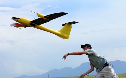
Drones May Help Predict Tornadoes In The Future. The march of technology is inevitable, but this will bring up some interesting (new) problems and challenges.
Courier-Post has a fascinating story - here's the intro: "
Fourteen minutes is how much time a city or town has between a tornado warning and when a twister touches ground,
according to the national average from the National Oceanic and
Atmospheric Administration. But that warning time could increase to an
hour with the help of data from unmanned aerial vehicles, commonly
called drones, according to Jamey Jacob, an aerospace and engineering
professor at Oklahoma State University..."
Photo credit above: "
University of Colorado-Boulder unmanned aerial aircraft and graduate student Kevin Rauhauser on June 17, 2013." (Photo: University of Colorado-Boulder).
Finally, A Truly Smart Smart-Watch. Now is something I might actually use; details from
gizmag.com: "
The Qualcomm Toq
has one of the nicest displays we've seen in any of the early
smartwatches. Its wireless charging doesn't hurt things either. The
watch's software, though, landed with a pretty narrow feature set. Well,
that feature set just got a shot of adrenaline today, as a new update
lets the Toq join the small list of smartwatches that support voice
dictation. Read on for Gizmag's quick hands-on...."
All-Carbon Electric Superbike.
Now you can be clean and green on a screaming machine (well - it
doesn't scream, but it will get you from point A to B at a very rapid
clip). Here's an excerpt from Gizmag: "...This
week I've been riding about on an electric motorcycle that weighs about
180 kg and has 70 horsepower and 144Nm of torque (review video coming
soon). That bike felt seriously fast – it took off like an rocket at the
lights and really stretched your arms out in a way I didn't expect. The
experience made one thing clear to me – the pace of development in
electric motorcycles is absolutely frenzied..."
Trident Launches World's Fastest Diesel Sports Car". A range of 2,000 miles on a tank? But how does it handle on snow and ice? One of my favorite tech/geek/environment sites,
Gizmag, has more information; here's an excerpt: "
British
sports car marque Trident is sending its Iceni sports car speeding to
market, calling it the "fastest and most fuel efficient diesel sports
car" available. The car uses a patented torque multiplication technology
to combine 190 mph (306 km/h) worth of speed potential with up to 2,000
miles (3,219 km) of driving per tank of fuel..."
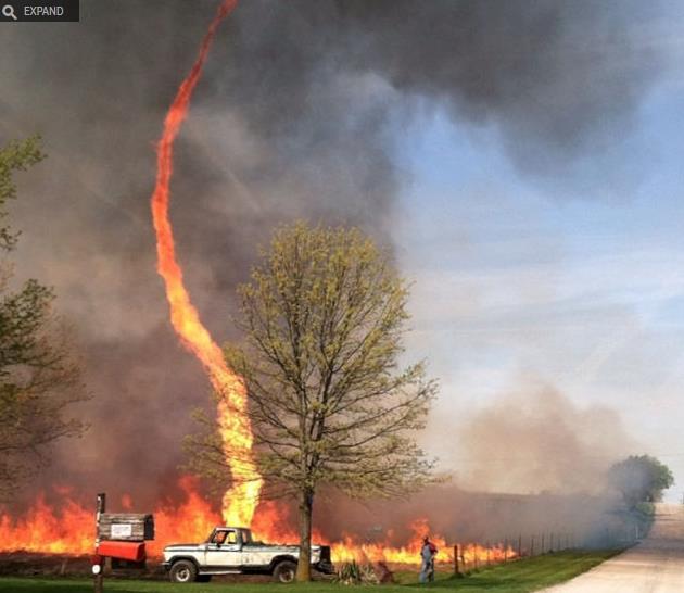
Image of the Day: Firenado! This is pretty incredible, evidence of tinder-dry (extreme) fire conditions. Thanks to
Sploid, from Gizmodo: "
Fire twister. Fire tornado. Firenado! Whatever you want to call these suckers of flames and souls, this instagram by NiceJalapeño is pretty damn cool (and, like she says, pretty scary in person.) I hope they make Firenado: The Movie soon."
TODAY: Early shower or thunderstorm (best chance south). Some sun. Winds: E 15. High: 67
WEDNESDAY NIGHT: Unsettled with a shower or T-shower possible. Low: 58
THURSDAY: Sticky, windy & warmer. Strong/severe T-storms. High: 79
FRIDAY: Showers taper, slow PM clearing. Wake-up: 54. High: 59
SATURDAY: Nicer day of the weekend. Partly sunny. Showers arrive at night. Wake-up: 40. High: 69
MOTHER'S DAY: Humid. Few T-storms for mom. Wake-up: 52. High: 71
MONDAY: Rain, heavy at times. Temperatures holding steady. Wake-up: 53. High: 55
TUESDAY: Cooler & drier with more clouds than sun. Risk of a jacket. Wake-up: 40. High: 57
Climate Stories....
National Climate Assessment. Over 114 NOAA scientists contributed to the latest National Climate Assessment; details below.
Climate Change Study Finds U.S. Is Already Widely Affected. Justin Gillis summarizes the latest National Climate Assessment at
The New York Times; here's an excerpt: "
The
effects of human-induced climate change are being felt in every corner
of the United States, scientists reported Tuesday, with water growing
scarcer in dry regions, torrential rains increasing in wet regions, heat
waves becoming more common and more severe, wildfires growing worse,
and forests dying under assault from heat-loving insects. Such sweeping
changes have been caused by an average warming of less than 2 degrees
Fahrenheit over most land areas of the country in the past century, the
scientists found. If greenhouse gases like carbon dioxide and methane
continue to escalate at a rapid pace, they said, the warming could
conceivably exceed 10 degrees by the end of this century..."
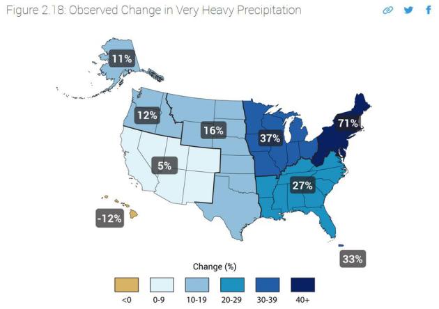
* Observed Changes in Very Heavy Precipitation (1958 to 2012) courtesy of the latest
National Climate Assessment.
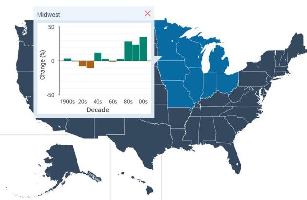
Climate Assessment Report: Midwest. Here are specific ways a changing, more volatile climate is already
impacting weather patterns across the Midwest, courtesy of the latest
National Climate Assessment: "
The
Midwest’s agricultural lands, forests, Great Lakes, industrial
activities, and cities are all vulnerable to climate variability and
climate change. Climate change will tend to amplify existing risks
climate poses to people, ecosystems, and infrastructure. Direct effects
will include increased heat stress, flooding, drought, and late spring
freezes. Climate change also alters pests and disease prevalence,
competition from non-native or opportunistic native species, ecosystem
disturbances, land-use change, landscape fragmentation, atmospheric and
watershed pollutants, and economic shocks such as crop failures, reduced
yields, or toxic blooms of algae due to extreme weather events. These
added stresses, together with the direct effects of climate change, are
projected to alter ecosystem and socioeconomic patterns and processes in
ways that most people in the region would consider detrimental."
Highlights of the National Climate Assessment, courtesy of
Climate Nexus:
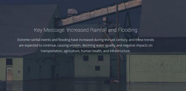
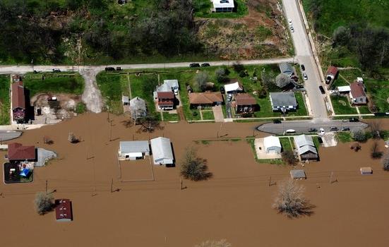
FLOODING
- Large-scale flooding can occur due to extreme precipitation in the
absence of snowmelt, for example, Rush Creek and the Root River in
August 2007 and multiple rivers in southern Minnesota in September 2010.
These warm season events are projected to increase in magnitude.
(Image: AP).
INCREASED TEMPERATURES, EXTREME PRECIPITATION EVENTS
- The rate of warming in the Midwest has markedly accelerated over the
past few decades. Between 1900 and 2010, the average Midwest air
temperature increased by more than 1.5°F. Since 1991, the amount of rain
falling in very heavy precipitation events has been significantly above
average. This increase has been greatest in the Northeast, Midwest, and
upper Great Plains – more than 30 percent above the 1901-1960 average.
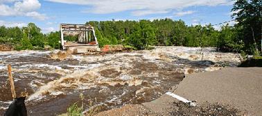
THREATS TO INFRASTRUCTURE
- Water infrastructure for flood control, navigation, and other
purposes is susceptible to climate change impacts and other forces
because the designs are based upon historical patterns of precipitation
and streamflow, which are no longer appropriate guides. (Image: Media
Matters).
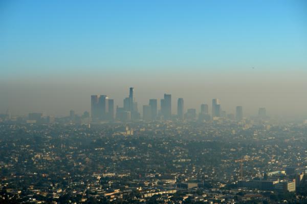
AIR QUALITY
- In the Midwest region, including Minnesota, in 2008, over 26 million
people lived in counties that failed the National Ambient Air Quality
Standards. Since many air pollutant emissions are enhanced by warmer
temperatures, warmer temperatures will lead to worsening of air quality.
Degraded air quality due to human-induced emissions and increased
pollen season duration are projected to be amplified with higher
temperatures, and can harm human health.
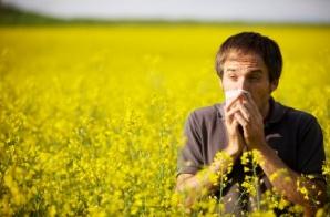
Not Your Imagination: Allergy Season Really IS Longer. The Culprit? Climate Change. Here's an excerpt from a story at Rick Kupchella's
BringMeTheNews.com: "
Ragweed
pollen season has lengthened by 24 days in the Minnesota-North Dakota
region between 1995 and 2011. In other parts of the Midwest, pollen
season has gotten longer by anywhere from 11 days to 20 days. These are
just two of the many findings in a new federal report, called The National Climate Assessment, which analyzed regional and state-level effects of global warming..."
Climate Change Report: Iowa Vulnerable to more Floods, Droughts. Here's an excerpt from a story at
The Des Moines Register: "
A
national report today says climate change will amplify existing risks
to Iowa's urban and rural residents, including intense heat, flooding
and drought. Residents in Midwest cities could see some of the greatest
impacts. "Increased heat wave intensity and frequency, increased
humidity, degraded air quality, and reduced water quality will increase
public health risks," the report from President Barack Obama's
Administration said..."
* Changes in Precipitation from 1901 to 2012, from the latest
National Climate Assessment.
** Stanford University to Purge $18 Billion of Coal Stock. The New York Times
reports.
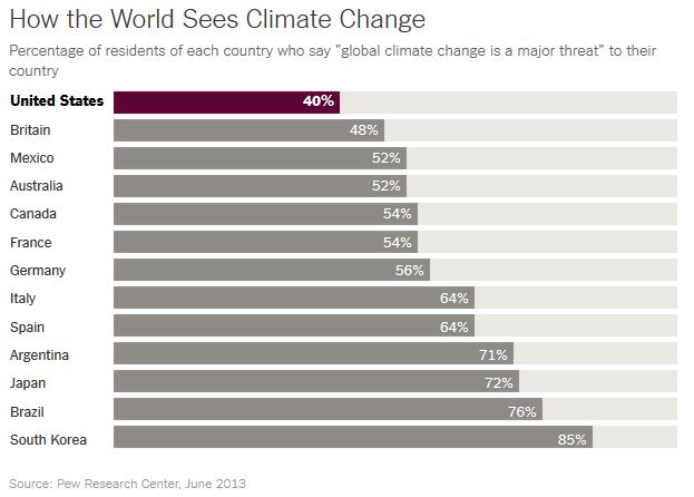
Americans Are Outliers In Views On Climate Change. But if it ever interferes with the NFL or Netflix God help us. Here's a clip from
The New York TImes: "...
Perhaps
more than people in any other rich nation, Americans are skeptical that
climate change is a dire issue. In Pew Research Center surveys
conducted last spring, 40 percent of Americans said that global climate
change was a major threat to their country. More than 50 percent of
Canadians, Australians, French and Germans gave that answer. More than
60 percent of Italians and Spaniards did. And more than 70 percent of
Japanese did..."
Graphic credit above: New York Times, Pew Research Center, June 2013.
Extreme Weather Is Coming To A Coastal City Near You.
Forbes has the story - here's an excerpt: "
Trillions
of dollars in assets are located in huge coastal cities like New York.
But plans for flooding have been minimal. Recent disasters in the U.S.,
including Hurricane Sandy in 2012, have vividly revealed how unprepared
we are for floods. Population density in coastal flood zones is expected
to grow 25 percent by 2050; at the same time, climate change means the
sea level will rise. So: more people will be affected by more floods.
What do we do? A group of researchers, led by Jeroen Aerts at VU
University Amsterdam, used New York City as a test case. They used
computer simulations to create more than 500 possible storm surges, that
varied intensity from low-probability extreme events to more frequent
storms..."
If You're Concerned About Climate Change, You Should Support Nuclear Power.
(Full disclosure: my company does some consulting work for Excel
Energy, which has nuclear interests). That said, my moderating views
concerning nuclear power arose long before this recent business
opportunity. I think I have a unique perspective on this. I grew up 23
miles downwind of TMI, Three Mile Island, outside Harrisburg, PA, the
nuclear plant that suffered a catastrophic accident and partial meltdown
in 1979. I was there for the partial melt-down and scare regarding a
hydrogen bubble breaching the containment shell. Our bags were packed,
we were ready to evacuate. My father told me that we would be alright,
that he had a job lined up in California. The Pennsylvania Turnpike was
scheduled to be 1 way, 4 lanes of traffic heading away from Harrisburg
and the TMI nuclear plant. You can only imagine the impact that had on
me (and on everyone else in the path of potential radioactivity). I
marched against nuclear power in Washington D.C. in 1980 and produced a
10-part series on nuclear safety at a previous TV station, WNEP-TV. But
my views have changed in recent years, as the gravity and full extent of
the climate change threat has become increasingly clear.
I'm all
for renewables, and I hope and expect there will come a day when most of
our energy comes from clean sources. But short-term wind, solar and
even cleaner-burning natural gas can't provide the
scale we need
to keep the lights on and the energy powered up. I realize this is a
sensitive subject for many environmentalists, but I'm not sure we have
any other viable, short-term options. That said, we need to find safer,
smaller, cheaper, more sustainable forms of nuclear power that address
the long-term waste challenge head-on. Here's an excerpt of a recent
story at
Forbes that resonated with me: "...
I
used to be anti-nuclear. But, several years ago I had to reevaluate my
thinking because if you agree with the world’s leading climate
scientists that global warming is real and must be addressed immediately
then you cannot simply oppose clean, low-carbon energy sources. As a
former Environmental Protection Agency (EPA) administrator and former
director of the White House Office of Energy and Climate Change Policy, I
have long championed clean air and the need to limit the dangerous
pollutants that contribute to climate change. In doing so, I have come
to fully appreciate the role that our current nuclear energy facilities
play in meeting our energy needs without increasing carbon pollution..."
File photo: CNN.


No comments:
Post a Comment