65 F. average high on May 2.
48 F. high on May 2, 2013.
Trace of rain fell yesterday.
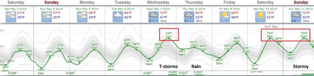
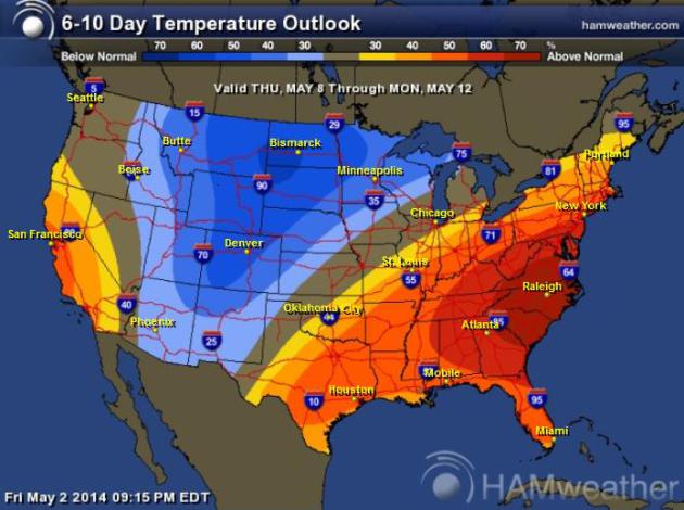
60s likely next week; 70s possible Wednesday.
Getting Better
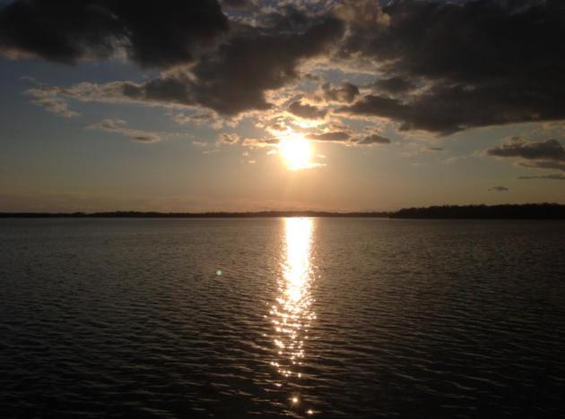
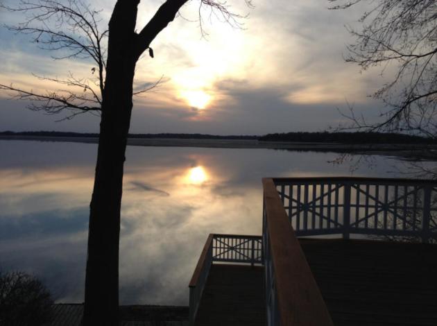
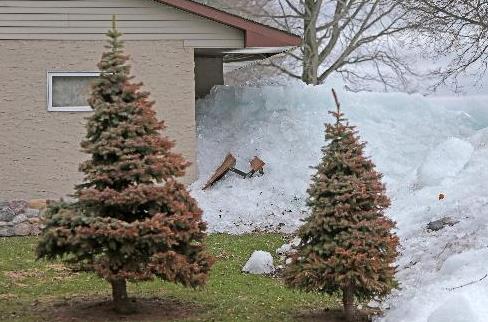
So it's come to this. Yesterday, when the sun finally came out in all its glory, the meteorologists I work with crept up to the Amish Doppler (window) and began clapping. Kind of sad. Moss is now forming on my north side. Daffodils coming up in the yard are doing the backstroke, but my rice paddies are coming along nicely.
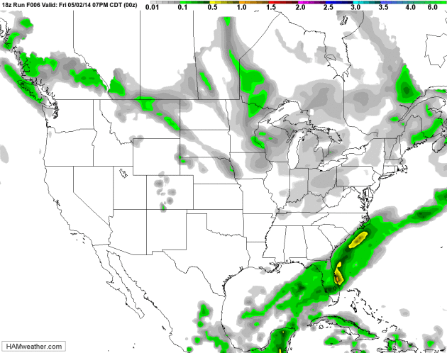
Nearly 10 inches of precipitation has fallen on MSP since January 1, 3.63 inches wetter than average. With any luck a deepening drought spreading from California to the Plains won't creep back up to our latitude.
I still see a cool bias into much of May; the core of the jet stream still 200-400 miles farther south than usual for this time of year. But we're stumbling in the right direction.
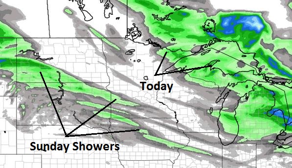
Showers sprout near Duluth later today, but much of Minnesota salvages some sun with highs near 60F. A few light showers may brush far southern Minnesota Sunday morning - heavier T-storms are brewing for the middle of next week. A few could even be severe as temperatures rise above 70F.
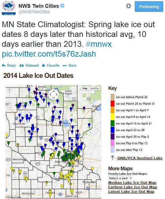
In today's weather blog below: CO2 levels hit a new record, the most Great Lakes ice in April since 1973 and Minnesota ice-out dates are running 8 days later than average.
Never a dull moment.

- April precipitation totals were variable across Minnesota, ranging from less than two inches in southwest and north central Minnesota counties, to over six inches in east central, south central and southeast Minnesota locales. In the wetter areas, monthly precipitation totals approached or exceeded all-time record highs for the month of April.
- Average monthly temperatures for April in Minnesota were below historical averages. It was the sixth consecutive month of below-average temperatures.
- The U. S. Drought Monitor places portions of southwest Minnesota in the Moderate Drought category.
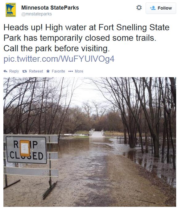
- Stream discharge values are high to very high at most Minnesota monitoring locations. Minor flooding is occurring in some areas. Moderate flooding is underway or projected at a few locales along the Red River of the North.
- Most lakes in the northern one-quarter of Minnesota remain ice covered. This spring, lake ice out dates are approximately eight days later than historical median ice out dates, but 10 days earlier than in 2013.
Speaking of ice....
Wall of Ice Damages Homes, Threatens Resort Near Mille Lacs. It's deja vu all over again. Here's a clip from an article and video at The Star Tribune: "Driven
by high winds, ice from Lake Mille Lacs has gone on a rampage in recent
days, bursting into homes, tearing up the shoreline, blocking roads and
forming massive mounds in yards. The problems are mostly in the
Garrison, Minn., area on the western shore of the lake, which has taken
the brunt of the east winds accompanying recent rains. Last year, it was
the southeast corner of the lake, near Isle and Wahkon..."
Photo credit above: "Ice
swept and damaged Randy Dykhoff's property along the shore north of
Garrison, MN Thursday, May 1, 2014. Dykhoff, of Mound, was notified by
the Sheriff's office of the damage that had occurred last Sunday. He
said he carried several wheel barrow loads of ice through his kitchen.
He has owned the property since 1997 and It was the first time he has
experienced this." Photo: Elizabeth Flores.
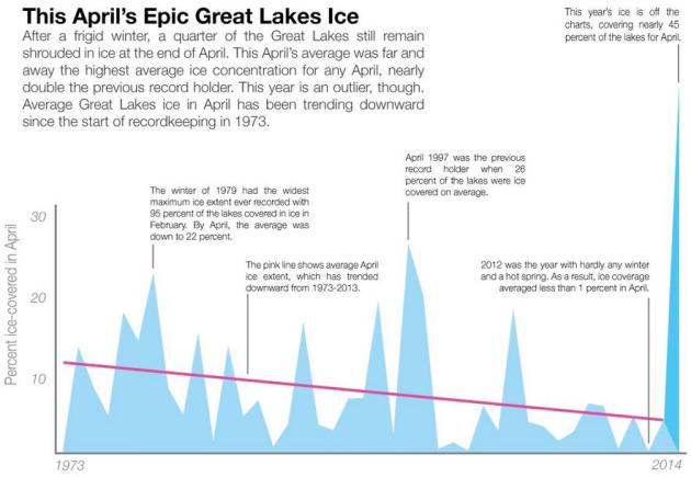
Winter Won't Let Go: Great Lakes Still On Ice. The most April ice since 1973? Climate Central has an update; here's an excerpt: "April has come and gone but a record amount of ice still remains on the Great Lakes.
This April was the lakes’ iciest on record after a near-record winter,
and the season has been notable for how early ice formed and how long
it’s lingered. At the close of April, nearly a quarter of the
five Great Lakes — the largest group of lakes on Earth — still have ice
on them and ice is likely to linger for weeks to come according to the Great Lakes Environmental Research Laboratory. That makes the month far and away the iciest April since recordkeeping began in 1973..."
Image credit: Climate Central and Great Lakes Environmental Research Laboratory.
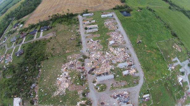
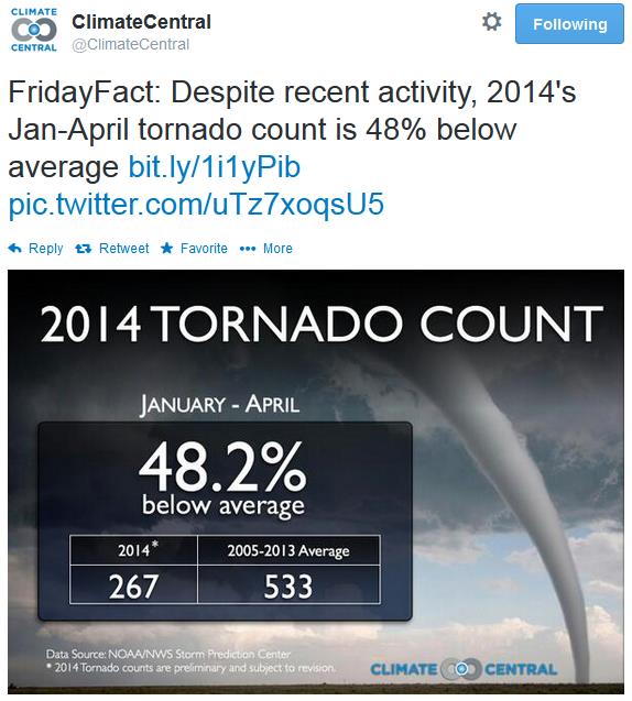
Alabama Tornado Outbreak 2014 By The Numbers: 20 Tornadoes, 153 Miles of Damage. Meteorologist Paul Gattis has a good update on the extent of damage at al.com; here's a clip: "It wasn’t the tornado outbreak of April 27, 2011. In
fact, it wasn’t even close. But the storms that swept across Alabama on
Monday and into early Tuesday morning was the most significant outbreak
since that historic day three years ago. According to storm surveys
from the National Weather Service, 20 tornadoes touched down across
central and northern Alabama – including two that touched down just
north of the Alabama-Tennessee state line in Lincoln County, Tenn..."
Image credit above: "Sky
View HSV used a quadcopter to capture footage from storm-ravaged areas
in the Bay Hill Marina, Coxey community and along 7 Mile Post Road in
Limestone County Wednesday, April 30, 2014." (Contributed by Sky View HSV).
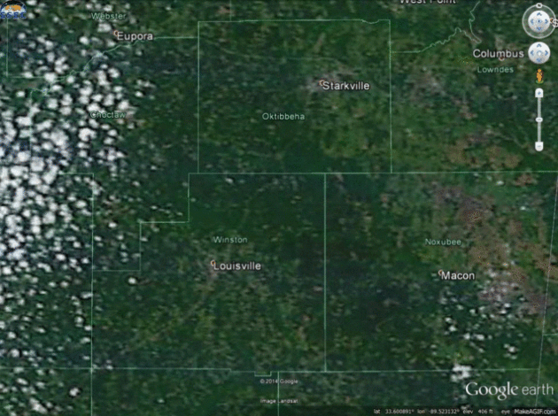
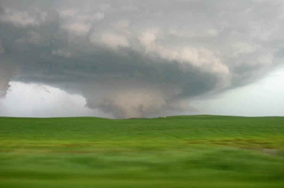
Tornadoes Carve Scars Into The Earth That Are Visible From Space.
The EF-4 that hit Vilonia and Mayflower was a monster; winds may have
peaked close to 200 mph. The length, width and ferocity of the tornado
becomes apparent when you can see the debris field from space. The Vane
and Newsweek report; here's an excerpt: "Almost three dozen people were killed in the latest tornado outbreak
that tore through the Deep South this week. The outbreak included
several "long-track" tornadoes, which can drag across the landscape for
tens and sometimes hundreds of miles, leaving behind scars on the
earth's surface that can be seen from space. Gawker's The Vane
blog created gifs out of satellite images that clearly show the scars,
eerie reminders of the scale of the havok the tornadoes wreaked. These
scars tend to dissapear in several months as vegetation regrows, though
they linger for longer in more populated regions, according to The Vane..."
Image above: The Vane.

Mamma Mia! Another Tornado Video from Italy. More tornadoes in unlikely places. Mike Smith Enterprises Blog has the video clip.
Tornadoes Most Likely To Occur During Multi-Day Spans. That was certainly the case this past week, and it's something I see all the time. Red Orbit has an interesting article; here's a clip: "...In
a report published by the journal Monthly Weather Review - Jeff Trapp, a
planetary sciences professor at Purdue, said a bout of 20 or greater
reported tornadoes had a 74 percent chance of occurring throughout a
period of tornado activity sustained for three or more days. Throughout
those exact same periods, a tornado with an intensity that scored 3 or
higher out of 5 on the Enhanced Fujita scale had a 60 percent chance of
hitting, the report added..."
In a report published by the journal Monthly Weather Review – Jeff Trapp,
a planetary sciences professor at Purdue, said a bout of 20 or greater
reported tornadoes had a 74 percent chance of occurring throughout a
period of tornado activity sustained for three or more days. Throughout
those exact same periods, a tornado with an intensity that scored 3 or
higher out of 5 on the Enhanced Fujita scale had a 60 percent chance of
hitting, the report added.
“Two extreme tornado events last year led to 32 deaths, injured more than 377 and cost $2 billion in damage and inspired this study,” Trapp said in recent statement. “Unfortunately, the devastating tornadoes these past few days, tragically, seem to be bearing out the results.”
Read more at http://www.redorbit.com/news/science/1113135713/tornado-activity-over-multiple-days-050114/#cTMX1CYYq7iuhWJC.99
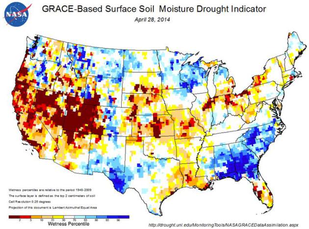
No Drought Relief In Sight For Desiccated West. Climate Central has more on a deepening drought that's spreading from California into the Plains; here's an excerpt: "...The
driest places today are the places that have been dry for 2 or 3 years
or longer: California, northwest Nevada and the southern Great Plains of
the Texas and Oklahoma panhandles, northeast New Mexico and along the
Colorado-Kansas border. In other words, drought is bringing the dust
back to the Dust Bowl territory of the 1930s..."“Two extreme tornado events last year led to 32 deaths, injured more than 377 and cost $2 billion in damage and inspired this study,” Trapp said in recent statement. “Unfortunately, the devastating tornadoes these past few days, tragically, seem to be bearing out the results.”
Read more at http://www.redorbit.com/news/science/1113135713/tornado-activity-over-multiple-days-050114/#cTMX1CYYq7iuhWJC.99
Image credit above: U.S. Drought Portal.
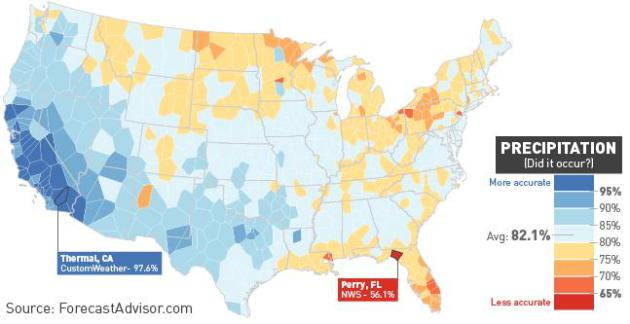 What Parts Of The Country Get The Worst Weather Predictions?
One year probably doesn't "prove" anything, statistically, but every
meteorologist truly does believe that their market, their city, is the
hardest to predict the weather for. A friend forwarded this story along
to me, courtesy of ForecastAdvisor, The Vane at Gawker. Here's a clip: "...The
easiest variable to predict was precipitation, with an average of 82.1
percent accuracy. This is largely because precipitation is simplified to
a "yes/no" proposition—predicting clear skies every day would net you
70 percent accuracy in many parts of the country—but also because rain
and snow are also fairly predictable across large swathes of the U.S. It
rarely rains in the southwest, and the outlets had the most difficulty
along the Gulf Coast (where intense thunderstorms are hit-or-miss most
of the year) and especially around the eastern Great Lakes, where a
large portion of the yearly precipitation falls in the form of
lake-effect snow..."
What Parts Of The Country Get The Worst Weather Predictions?
One year probably doesn't "prove" anything, statistically, but every
meteorologist truly does believe that their market, their city, is the
hardest to predict the weather for. A friend forwarded this story along
to me, courtesy of ForecastAdvisor, The Vane at Gawker. Here's a clip: "...The
easiest variable to predict was precipitation, with an average of 82.1
percent accuracy. This is largely because precipitation is simplified to
a "yes/no" proposition—predicting clear skies every day would net you
70 percent accuracy in many parts of the country—but also because rain
and snow are also fairly predictable across large swathes of the U.S. It
rarely rains in the southwest, and the outlets had the most difficulty
along the Gulf Coast (where intense thunderstorms are hit-or-miss most
of the year) and especially around the eastern Great Lakes, where a
large portion of the yearly precipitation falls in the form of
lake-effect snow..."


Twitter Is Not Dying. As a retort to a recent article at The Atlantic, Slate makes the case that Twitter is a different creature altogether, and should be judged accordingly. Here's an excerpt: "...But Wall Street—along with everyone else who’s down on Twitter because it has “a growth problem”—is
making a mistake by comparing it to Facebook. Twitter is not a social
network. Not primarily, anyway. It’s better described as a social media
platform, with the emphasis on “media platform.” And media platforms
should not be judged by the same metrics as social networks..."
Tweet above: @TheEllenShow.


New Smart Bike Offers Turn By Turn Navigation. Soon your bicycle will be smarter than you are. Sorry, that sounded harsh, but amazing new tech is showing up (everywhere). Gizmag reports: "...Vanhawks
is hoping to get enough Valours on the road to form a mesh network of
users. Through this online community, users will be able to tap into
data on potholes, closed roads, blocked lanes collected by other Valours
to choose safer and smarter routes. In addition, if one's Valour is
stolen and another user happens to pass it by, a notification is sent
via the application to alert the original owner of its whereabouts...."


Photo credit above: Laurie Burkitt/The Wall Street Journal.

TODAY: Partly sunny, stiff breeze. Winds: NW 10-20. High: 58
SATURDAY NIGHT: Partly cloudy and cool. Low: 42
SUNDAY: Sunny intervals. Showers far southern Minnesota. High: 57
MONDAY: Early shower, then partial clearing. Wake-up: 43. High: 57
TUESDAY: Breezy, turning milder with some sun. Wake-up: 41. High: 63
WEDNESDAY: Warmer with T-storms, some strong/severe? Wake-up: 54. High: 74
THURSDAY: Periods of rain, possibly heavy. Wake-up: 51. High: 63
FRIDAY: Partly sunny, drying out. Wake-up: 48. High: 65
Climate Stories....
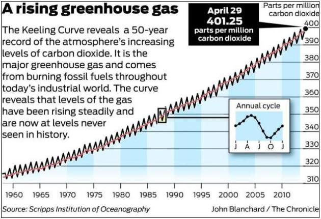
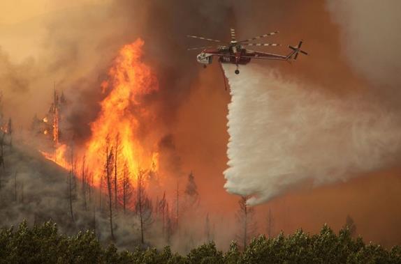
Photo credit above: "This Aug. 16, 2013 file photo shows helicopters battling the 64,000 acre Beaver Creek Fire north of Hailey, Idaho." (AP Photo/Times-News, Ashley Smith, File).
As Wildfire Fear Rises, U.S. Tanker Fleet Incomplete. The Washington Post reports.

Image credit: Katharine Hayhoe.
No comments:
Post a Comment