By Paul Douglas
According to NOAA, on this date in 1934 massive clouds of dust turned day into night. At midday cars drove with their lights on as dust drifted as deep as 6 inches over southern Minnesota. Dust got into homes and offices. In Chicago a 2-day dust storm dumped an estimated 12 million pounds of soil on the city. The Dust Bowl of the 30s was America's worst sustained environmental crisis. Since then sustained programs emphasizing soil conservation & land management have lowered the risk of a similar disaster. Crop rotation, contour plowing, terracing and drainage outlets may prevent a future dust bowl ever reaching Minnesota. But the southern Plains are experiencing exceptional drought right now. While local farmers here can't get into their fields because it's too wet. Crazy extremes.
Rain tapers to showers Monday, the atmosphere draped overhead may be unstable enough for a few severe storms, mainly south & east of the Twin Cities later Monday. Cool winds behind this slow-moving storm treat us to a cool week, feeling more like October than May.
Another surge of heat sparks a few T-storms by next Sunday. Long-range models hint at 60s & 70s for a (slush-free!) Memorial Day weekend.
===========================
SUNDAY NIGHT: Scattered showers/storms. Low: 55. Wind: ENE 10.
MONDAY: Rain likely with a few T-storms. High: 65. Wind: Turning WSW 10.
MONDAY NIGHT: Lingering showers early. Low: 42.
TUESDAY: Damp start, gradual clearing. High: 57
WEDNESDAY: Mostly cloudy and brisk. Wake-up: 39. High: 55
THURSDAY: More clouds than sun with a few sprinkles. Still brisk. Wake-up: 38. High: 50.
FRIDAY: Partly sunny, no humidity. Wake-up: 36. High: 57.
SATURDAY: More sun, feeling like spring again. Wake-up: 37. High: 64.
SUNDAY: Sunny start, late day T-storms. Wake-up: 46. High: 67.
==========================
This Day in Weather History
May 12th
1922: From shorts to sweaters at Morris. The temperature dropped from 91 to 26.
========================
Sunrise/Sunset Times
May 12th
SUNRISE 548 AM
SUNSET 831 PM
=======================
Averages for Minneapolis
May 12th
Average High: 68
Average Low: 48
======================
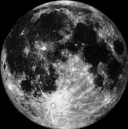
Moon Phase for May 12th at Midnight
1.5 Days Before Full (Flower) Moon
==========================
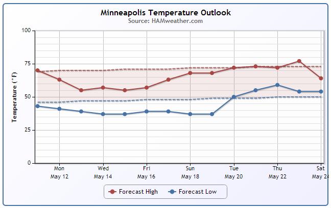
Minneapolis Temp Trend
Temperatures through the week ahead look quite chilly considering that we should have high temperatures averaging in the upper 60s now in mid May. We finally get back to average by the end of next weekend/early next week. Note also that temperatures look to dip into the 30s for several nights next week.
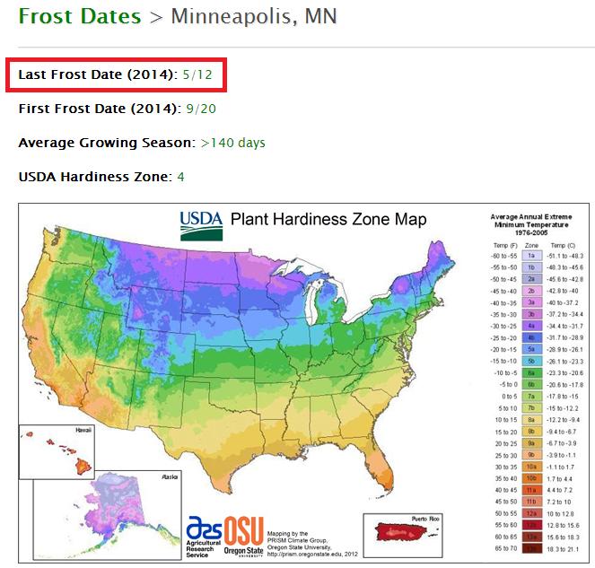
Mother's Day Flowers
Now that you've got a heap of new flowers from you family, you're probably wondering if you can plant them outside.
Here's a huge list of average last frost dates for a number locations across Minnesota.
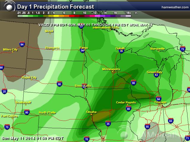
Soggy Weather Continues
Hard to root around in the garden with as wet as it has been. Unfortunately, our weather looks to stay somewhat unsettled through the next several days. Here's the precipitation forecast from AM Sunday to AM Wednesday. Note that the southeastern part of the state will have the best chance at 1" to 2" of rain or more.
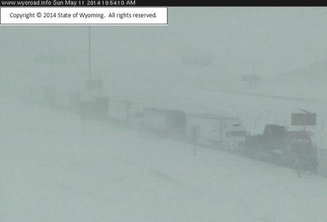
Snowy Sunday
Look at the webcam from near Cheyenne on Sunday around midday. This view from I-80 Roundtop East is where the interstate was shutdown from Cheyenne to Rawlins. Note the line of semi-trucks
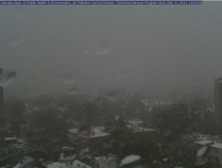
This was the view from Denver, CO around midday Sunday when the changeover from rain to snow was occurring.
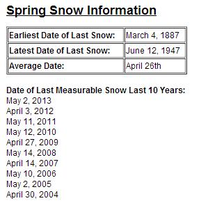
Denver Snow Stats
The National Weather Service out of Denver/Boulder, CO has a list of some of the spring snow stats for the area.
See more weather stats from the NWS Denver/Boulder, CO HERE:
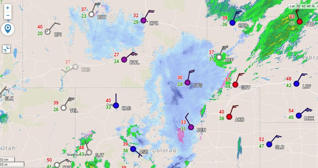
Sunday Snow
This is what the radar looked like around midday Sunday when some of the heaviest snow was coming down across the Rockies/Front Range. Crazy to think we can still get heavy snow in early/mid May...
Storm Moves East
Severe weather chances will continue through early week as our storm system chugs east. Heavy mountain snow will also end.
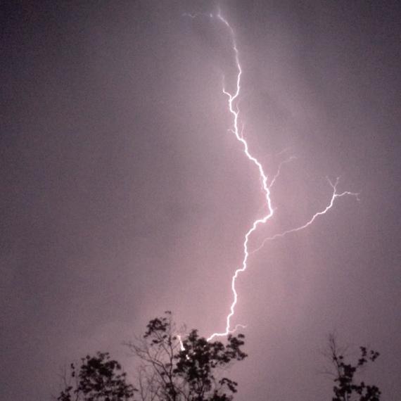
Lightning in Columbia, MO
Thanks to David E for sharing this picture out of Columbia, MO from over the weekend.
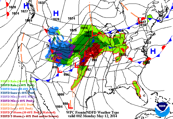
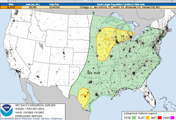
Severe Threat Continues Monday
Our storm system will continue move east into Monday. The Storm Prediction Center has issued another SLIGHT RISK from near San Antonio, TX to near Detroit, MI. Hail and high winds will be the primary threat, but an isolated tornado can't be ruled out.
...MID TO UPPER MS VALLEY/GREAT LAKES... AN UPPER-LEVEL TROUGH WILL MOVE INTO THE CNTRL AND NRN PLAINS ON MONDAY AS A COLD FRONT ADVANCES SEWD ACROSS THE MID MO VALLEY AND CNTRL PLAINS. AT THE START OF THE PERIOD...SCATTERED THUNDERSTORMS APPEAR LIKELY TO BE ONGOING NEAR THE EXIT REGION OF THE LOW-LEVEL JET IN PARTS OF THE UPPER MS VALLEY AND MID MO VALLEY. THIS ACTIVITY SHOULD MOVE EWD DURING THE DAY AS MODERATE INSTABILITY DEVELOPS AHEAD OF THE FRONT FROM IA SWD ACROSS MO. THUNDERSTORMS SHOULD INITIATE ALONG THIS CORRIDOR DURING THE AFTERNOON ALONG AND JUST AHEAD OF THE BOUNDARY. OTHER STORMS MAY INITIATE ACROSS THE WARM SECTOR NEWD ACROSS LOWER OH VALLEY INTO THE GREAT LAKES REGION. NAM FORECAST SOUNDINGS AT 00Z/TUE FROM CHICAGO IL SWWD INTO CNTRL MO SHOW MLCAPE AROUND 1200 J/KG WITH 30 TO 35 KT OF 0-6 KM SHEAR. THIS SHOULD BE ENOUGH FOR STORM ORGANIZATION AS CELLS INCREASE IN COVERAGE LATE MONDAY AFTERNOON. STEEP LOW-LEVEL LAPSE RATES AND UNIDIRECTIONAL WIND PROFILES SHOULD BE FAVORABLE FOR STRONG WIND GUSTS WITH SHORT-LINE SEGMENTS AND MULTICELL CLUSTERS. ISOLATED LARGE HAIL MAY ALSO OCCUR IN AREAS THAT DESTABILIZE THE MOST. FURTHER TO THE NORTHEAST...MODEL FORECASTS DEVELOP A POCKET OF ENHANCED INSTABILITY ACROSS LOWER MI BENEATH AN EWD MOVING UPPER-LEVEL RIDGE. IN RESPONSE...THUNDERSTORMS MAY INITIATE ON THE NRN END OF THE STRONGER INSTABILITY AS LOW-LEVEL CONVERGENCE BECOMES ENHANCED MONDAY AFTERNOON. FORECAST SOUNDINGS AT DETROIT AT 21Z/MON SHOW MLCAPE AROUND 1200 J/KG WITH 35 KT OF 0-6 KM SHEAR. IN ADDITION...LOW-LEVEL LAPSE RATES ARE STEEP AND THERE IS SOME DIRECTIONAL SHEAR BELOW 850 MB. THIS SHOULD BE ENOUGH FOR AN ISOLATED SEVERE THREAT WITH WIND DAMAGE AND HAIL POSSIBLE.
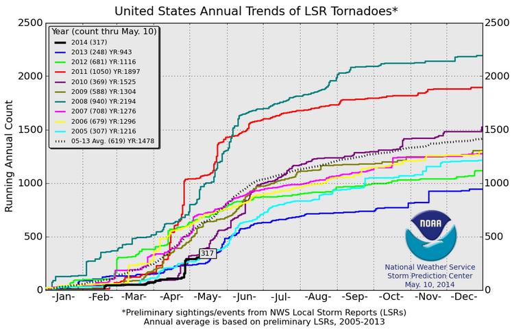
2014 Tornado Reports
We've certainly seen a recent uptick in the amount of tornadoes lately. However, according to NOAA's SPC, the 2014 PRELIMINARY tornado reports through May 10th were at 317. This is still below the short-term 2005-2013 average through May 10 is 619. Interestingly last year, there were 248; In 2011, there were 1,050 through May 10th!
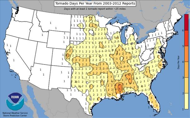
Tornado Days per Year
According to NOAA's SPC, the average number of tornado days per year is the highest in the Lower Mississippi Valley with as many as 5 tornado days per year! The central U.S. sees as many as 2 to 3 tornado days per year, while most locations in the western U.S. averages less than 1 tornado per year!
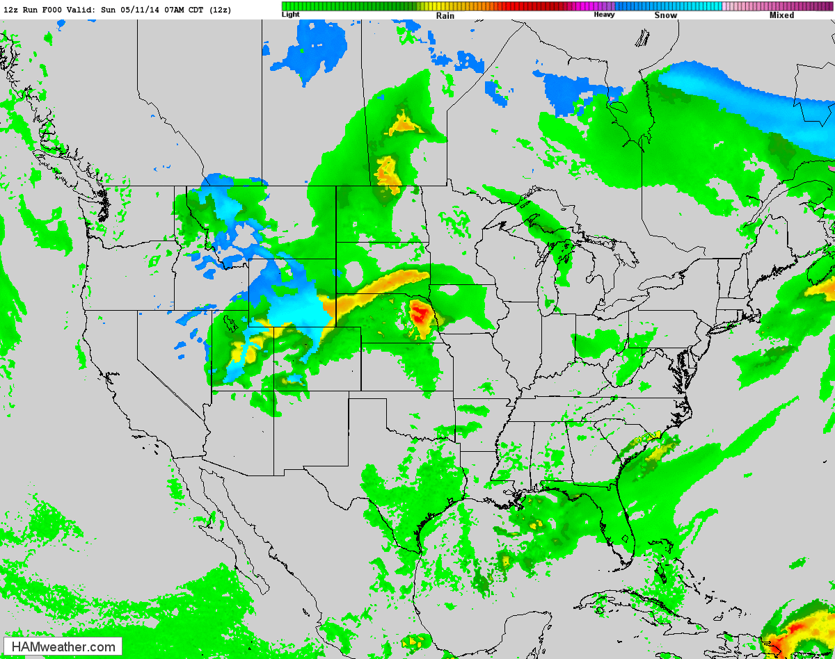
Future Radar
Soggy Weather
Thanks to Mary Reed Runyon for this picture out of Hatfield, KY who snapped this picture this weekend. Great shot!

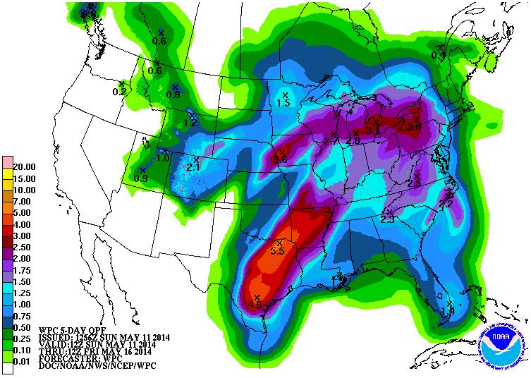
Heavy Rainfall Continues
Our current storm system will continue to shift east through the early week time frame. According to NOAA's HPC, the 5 day precipitation forecast suggests nearly 2" to 4" of rainfall through AM Friday. Some of the heaviest looks to fall across parts of central/eastern Texas.
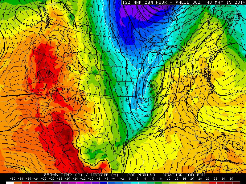
Chilly Week Ahead
Post storm system, temperatures will tumble quite a bit. The image below shows temperatures a few thousand feet off the ground by Wednesday.
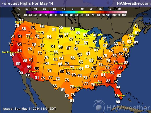
Highs Wednesday
Note that a majority of the nation will be cooler than average in the middle part of the country. However, temperatures in the western U.S. and in the Southeastern U.S. will be warmer than average.
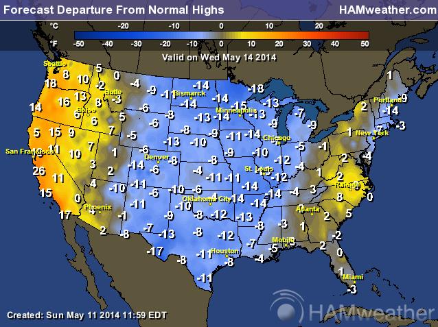
Highs From Normal on Wednesday
High temperatures on Wednesday will be nearly 10F to 15F below average in the middle part of the country.
Thanks for checking in and have a great week ahead! Don't forget to follow me on Twitter @TNelsonWNTV

No comments:
Post a Comment