By Paul Douglas
A mom's hug lasts long after she lets go. My late mother didn't push me into a career I had no interest in. "Do what you love, you'll find a way to make a life" she said.
After a tropical storm flooded our home in 1972 she encouraged me to buy a CB radio, which I promptly set up in our basement. Every evening at 6 PM sharp I would "broadcast" the weather to a group of friendly strangers on CB channel 7. I was hooked. "Breaker-breaker!" No sign of my CB radio - or 8-Track for that matter. Give your mom extra hugs today.
Early sun gives way to another round of thunder showers later Sunday; a few may turn severe over far southern Minnesota by Sunday night. The next moisture-rich southern storm tracks close to MSP by Monday, soaking many towns with another inch of rain, as temperatures tumble into the 50s.
The last 6 months have trended cooler than average for Minnesota, and this week will be no exception. 60s & showers next weekend may give way to a warmer surge in time for Memorial Day Weekend. At some point fairly soon you WILL be able to wander around in shorts and flip-flops.
At least lawns are green and at the rate we're going drought won't be an issue for Minnesota's farmers.
============================
SATURDAY NIGHT: Shower/storm chance. Low: 52. Wind: SSE 5-15.
MOTHER'S DAY: Showers/storms developing late and at night, some heavy. High: 69. Wind: Turning WNW 5-10.
SUNDAY NIGHT: Scattered showers/storms. Low: 58. Wind: NE 10.
MONDAY: Rain likely with a few T-storms. High: 61. Wind: NW 10.
TUESDAY: Damp start, gradual clearing. Wake-up: 44. High: 58
WEDNESDAY: Partly sunny, cool breeze. Hello April. Wake-up: 39. High: 59
THURSDAY: More clouds than sun, still brisk. Wake-up: 37. High: 57.
FRIDAY: Clouds increase, showers late. Wake-up: 36. High: 55.
SATURDAY: Sun/clouds mix with a few PM showers possible. Wake-up: 41. High: 62.
===========================
This Day in Weather History
May 11th:
1915: A waterspout was seen at Lake Mills.
==========================
Sunrise/Sunset Times
May 11th
SUNRISE 549 AM
SUNSET 830 PM
==========================
Averages for MSP
Average High: 68
Average Low: 47
=========================
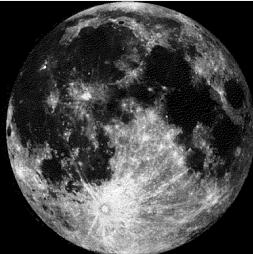
Moon Phase for May 11th at Midnight
2.5 Days Before Full Moon
===========================
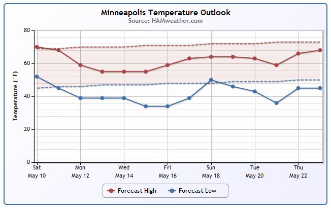
Minneapolis Temperature Outlook
Here's a quick glance at the Minneapolis temperature trend through May 23rd and note the dip in temperatures through much of next week. The sold lines (forecast temps) look to be consistently below the averages (dashed lines).
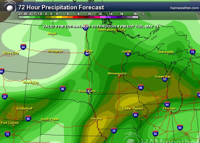
Soggy Weather Continues
Take a look at the precipitation forecast below. The forecast from 8pm Saturday to 8pm Tuesday suggests total rainfall amounts ranging from 1" to nearly 2" or more! The heaviest precipitation looks to fall over the southeastern part of the state.
Fishing Opener
It seemed like the winter lasted forever, didn't it? Sure was nice to see boats on area lakes again! Thanks to my good friend Tony Olsen who snapped these pictures of Steve and Levi with their big catches from northern Minnesota on Saturday.

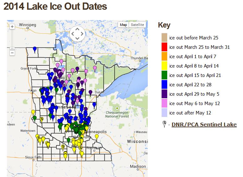
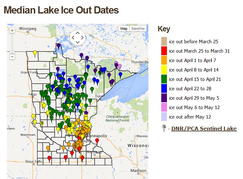
2014 Ice Out Dates
Ice out dates were a little behind schedule this year. Many lakes saw ice out dates a couple of weeks later than normal. Here are the ice out dates for some lakes for 2014
See more details from the MN DNR HERE:
Average Ice Outs
Note that most of far northern Minnesota lakes are typically ice out by mid April/early May. Some of those lakes just went ice out over the lake week or so!
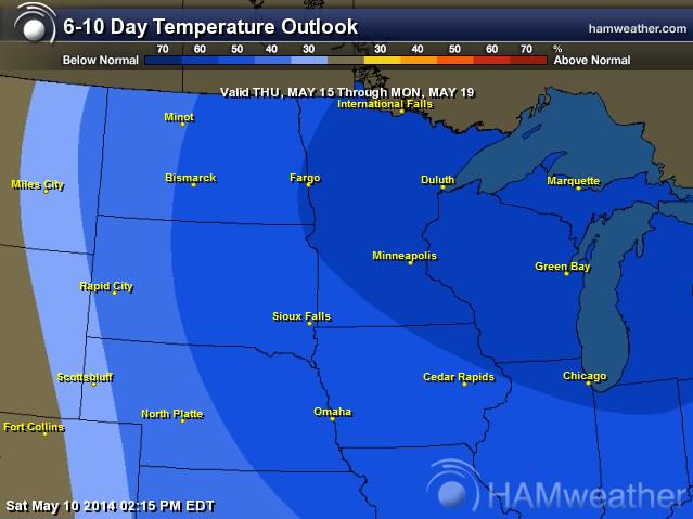
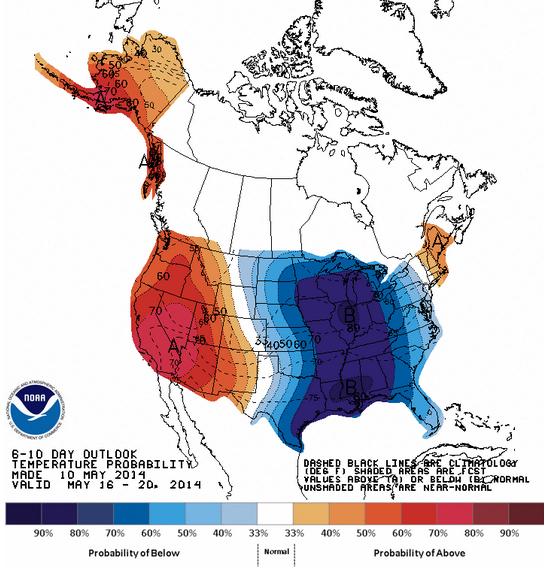
Temperature Outlook
Spring hasn't been too 'springy' yet this year. We've been dealing with cool and soggy weather for a majority of the time and the extended outlook doesn't look all that promising either. According to NOAA's Climate Prediction Center, the 6 to 10 day temperature outlook, that takes us from Thursday, May 15th to Monday, May 19th, the Midwest stays cooler than normal once again.
Happy Mother's Day!
I recently got back from visiting my parents in Phoenix, AZ. The weather was fantastic, but the company was even better! They recently moved from full-time Minnesota residents to full-time Arizona residents. It's hard seeing them on a regular basis now, but it sure is nice to have such great technologies these days. Even though we are so far apart, between the phone calls, Skypes and facetimes, it doesn't feel like they are so far away. I wish my Mom, my wife and all the other wonderful mom's out there a Happy Mother's Day! Kick your feet back, relax and let others wait on you today, you deserve it!
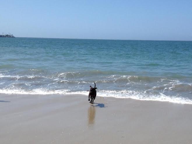
Beach Weather
Thanks to my good friend Stephanie Trindade for the picture below from Long Beach, CA earlier this week. Looks like the pooch had a good time!
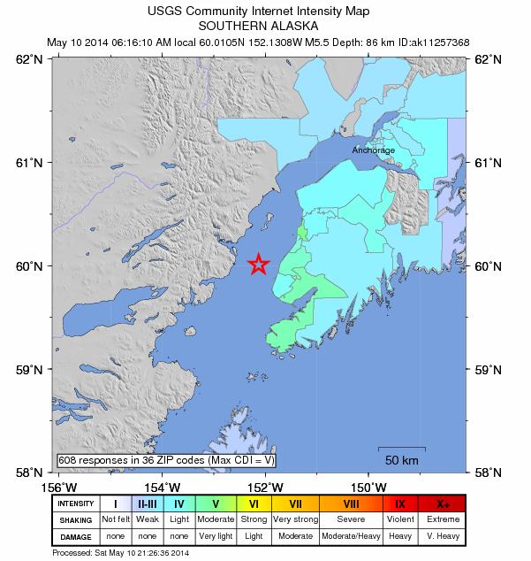
Southern Alaska Quake
On Saturday morning, a 5.5 magnitude quake shook southern Alaska. According to the USGS, the shaking was felt as far north as Anchorage. One of my good friends, Monica Zappa (who ran in the Iditarod this year) said she felt it near Anchorage and it woke her up!
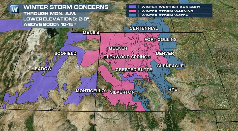
Unsettled Weather Continues
Our current weather system moving into the middle part of the country through early next week will be cause for concern for some on Mother's Day Sunday. Severe weather potential, including tornadoes will be possible. Snow will also be ongoing across parts of the Rockies into early next week. Some in the mountains could see 1ft. to 2ft by the end of the weekend.
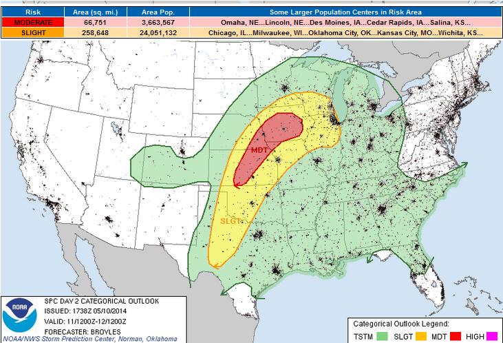
Severe Threat Sunday
The Storm Prediction Center has issued a MODERATE RISK of severe weather from Kansas to Iowa. There will be the potential for hail, high winds and tornadoes by PM Sunday. Keep an eye/ear on the weather.
...MID-MO VALLEY/CNTRL PLAINS... AN UPPER-LEVEL TROUGH WILL MOVE ACROSS THE FOUR CORNERS REGION SUNDAY AS DIFFLUENT SOUTHWEST MID-LEVEL FLOW REMAINS IN PLACE ACROSS THE CNTRL STATES. AT THE SFC...A COLD FRONT WILL ADVANCE SEWD ACROSS THE CNTRL PLAINS AS A WARM FRONT MOVES NWD ACROSS THE MID MO VALLEY. A CLUSTER OF THUNDERSTORMS MAY BE ONGOING IN THE MID MO VALLEY SUNDAY MORNING ON THE NOSE OF THE LOW-LEVEL JET. HOWEVER...MOST OF THE WARM SECTOR SHOULD REMAIN UNDISTURBED THROUGH EARLY SUNDAY AFTERNOON AS MODERATE TO STRONG INSTABILITY DEVELOPS. BY LATE AFTERNOON...NUMEROUS THUNDERSTORMS SHOULD INITIATE ALONG THE WARM FRONT FROM IA EXTENDING SWWD ALONG THE COLD FRONT INTO SE NEB AND CNTRL KS. DUE TO THE VERY UNSTABLE AIRMASS...STRONG DEEP LAYER SHEAR AND IMPRESSIVE LOW-LEVEL SHEAR...AN OUTBREAK OF SEVERE STORMS WITH MANY TORNADOES WILL BE POSSIBLE ACROSS THE REGION SUNDAY AND SUNDAY NIGHT. FORECAST SOUNDINGS FOR 00Z/MON ACROSS THE MODERATE RISK AREA FROM DES MOINES IA SWWD TO TOPEKA KS SHOW IMPRESSIVE SHEAR PROFILES COUPLED WITH STRONG INSTABILITY. THE NAM IS FORECASTING MLCAPE IN THE 2000 TO 3000 J/KG RANGE WITH 0-6 KM SHEAR OF 40 TO 50 KT. IN ADDITION...LONG LOOPED HODOGRAPHS RESULT IN 0-3 KM STORM RELATIVE HELICITIES OF 350 TO 500 M2/S2 SUGGESTING THE ENVIRONMENT WILL BE FAVORABLE FOR SUPERCELLS AND TORNADOES. SEVERAL STRONG OR LONG-TRACK TORNADOES APPEAR POSSIBLE ACROSS THE REGION AS THE LOW-LEVEL JET RAPIDLY BECOMES FOCUSED LATE SUNDAY AFTERNOON INTO SUNDAY EVENING. SUPERCELLS SHOULD BE ACCOMPANIED WITH LARGE HAIL AND WIND DAMAGE. HAILSTONES GREATER THAN 2 INCHES IN DIAMETER WILL BE POSSIBLE WITH THE MORE DOMINANT SUPERCELLS. UNCERTAINTIES STILL EXIST CONCERNING HOW THE EVENT WILL UNFOLD SUNDAY AND SUNDAY NIGHT WITH THE MAIN CONCERN BEING STORM MODE. THE IMPRESSIVE SHEAR ENVIRONMENT SHOULD PROMOTE STRONG ROTATION WITH SUPERCELLS BUT THE STORMS IN THE CNTRL PLAINS MAY EVENTUALLY MERGE INTO LINES ALONG THE COLD FRONT WHERE LOW-LEVEL LINEAR FORCING WILL BE MAXIMIZED. FURTHER TO THE NORTHEAST ALONG THE WARM FRONT IN IA...SUPERCELLS SHOULD HAVE AN EASIER TIME REMAINING DISCRETE. THE NAM FORECAST SOUNDINGS SHOW THE MOST FAVORABLE HODOGRAPH FOR STRONG TORNADOES AT DES MOINES IA AT 00Z/MON SUGGESTING THE WARM FRONT MAY HAVE THE GREATEST TORNADO POTENTIAL. AS THE LOW-LEVEL JET CONSOLIDATES DURING THE EARLY TO MID EVENING...THE GREATEST TORNADO THREAT MAY DEVELOP SWWD AS THE LOW-LEVEL JET CONSOLIDATES.
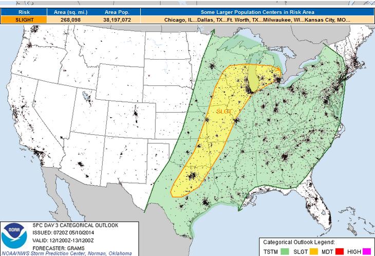
Severe Threat Monday
...CENTRAL GREAT LAKES TO SRN PLAINS... SCATTERED TO WIDESPREAD CONVECTION IS ANTICIPATED TO BE ONGOING AT 12Z/MON ALONG BOTH THE COLD FRONT OVER THE GREAT PLAINS AND DOWNSTREAM WAA REGIME OVER THE GREAT LAKES. WITH A RESIDUAL EML PLUME LIKELY ACROSS UNDISTURBED PORTIONS OF THE WARM SECTOR...DIURNAL HEATING SHOULD SUPPORT AT LEAST MODERATE BUOYANCY DEVELOPING AHEAD OF THIS ACTIVITY FROM THE OZARK PLATEAU TO S TX. HOWEVER...WIND PROFILES WITH SRN EXTENT WILL BE WEAKER AND PROBABLY CHARACTERIZED BY VEER-BACK SIGNATURES IN THE MID-LEVELS...GIVEN THE TRACK OF THE PLAINS SHORTWAVE IMPULSE. ALTHOUGH STORM CLUSTERS WILL LIKELY INCREASE IN COVERAGE DURING THE DAY...SMALL HODOGRAPHS SUGGEST CONVECTION WOULD STRUGGLE TO ORGANIZE AND GENERALLY REMAIN ON THE MARGINS FOR BOUTS OF SEVERE WIND/HAIL. FARTHER N FROM THE MID-MS VALLEY TO CNTRL GREAT LAKES...WIND PROFILES WILL BE MORE CONDUCIVE TO ROTATING UPDRAFTS. HOWEVER...EXTENSIVE ONGOING CONVECTION WILL PROBABLY HAVE DELETERIOUS EFFECTS ON INSTABILITY...ESPECIALLY WITH ANY POTENTIAL REDEVELOPMENT ALONG THE FRONT DURING PEAK HEATING. FOR NOW...WILL BROAD-BRUSH WITH LOW-END SLIGHT RISK PROBABILITIES.
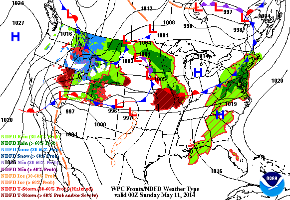
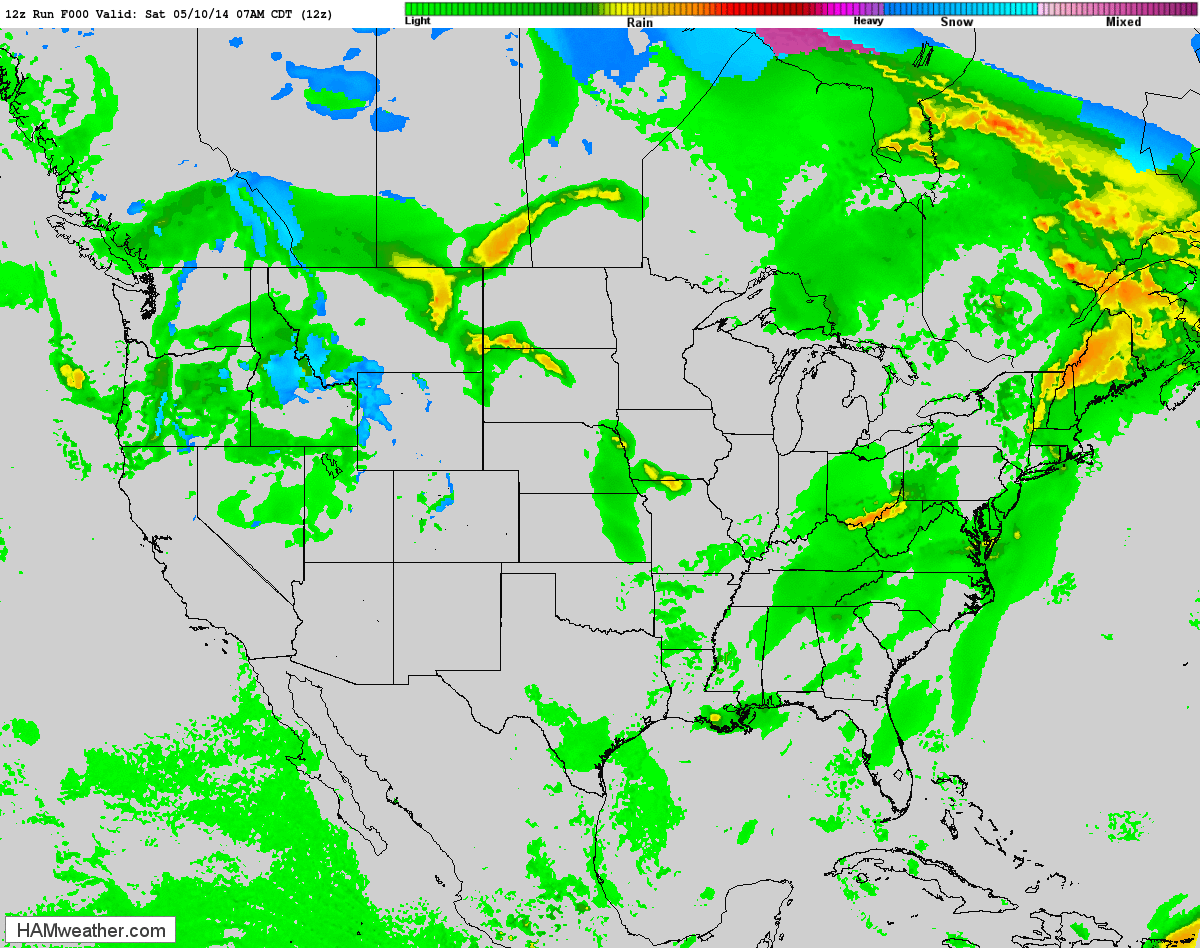
Forecast Ahead
Here's the higher resolution future radar through the rest of the weekend/early next week. From snow to severe thunderstorms, including tornadoes; it'll be pretty active over the next couple of days.
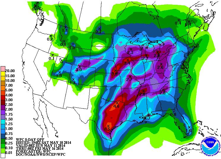
Heavy Precipitation Forecast
According to NOAA's HPC 5 day precipitation forecast, there may be spots in the middle part of the country that see 2" to 4" or more of rainfall by the middle part of next week. Convective precipitation could account for isolated higher tallies and the potential of flash flooding.
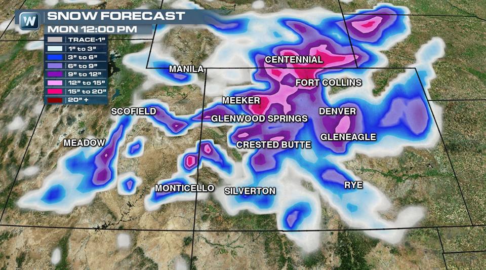
Mountain Snow Potential
HEAVY SNOWS DEVELOP IN THE RANGES OF SOUTHEAST WY AND CO AS WELL DEFINED COUPLETS OF UPPER DIVERGENCE/LOWER CONVERGENCE DEVELOP AND PERSIST ACROSS THESE AREAS...WITH SNOW IN MOUNTAINOUS AREAS STARTING IN THE UT WASATCH/UINTAS TONIGHT AND THEN CONTINUING IN FAVORED TERRAIN OF WY/CO THROUGH SUN. THE HIGHEST RISKS ARE IN THE FRONT RANGE OF NORTHERN CO AND CHEYENNE/LARAMIE RANGES IN ADJACENT WY...WHERE 1 TO 2 FEET ARE LIKELY...AND ISOLATED LOCATIONS MAY RECEIVED 3 FEET. TEMPERATURES INITIALLY START OFF TOO WARM FOR SNOW ON THE PLAINS BUT COOL WITH TIME...CHANGING THE RAIN TO SNOW STARTING IN THE FOOTHILLS FOLLOWED BY THE HIGH PLAINS OF WY/CO AND EVENTUALLY ADJACENT NE. ONCE THE RAIN CHANGES TO SNOW IN THE DENVER METRO AREA SUN AFTERNOON...HEAVY SNOW LIKELY FOLLOWS SUN AFTERNOON/EVENING. A SECONDARY MAXIMUM IS EXPECTED IN THE PALMER DIVIDE AS LOW LEVEL NORTHERN FLOW PROVIDES LOW LEVEL UPSLOPE FLOW. THE SNOW THREAT DRIFTS SOUTH DOWN THE SAN JUANS AND SANGRE DE CRISTIO MNTNS MON AND ENDS LATER MON NIGHT/TUE AS THE UPPER TROUGH DEPARTS EAST ON TO THE PLAINS AND DRYING ALOFT OCCURS OVER CO AND THEN NM.
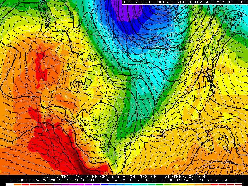
Cooler Weather Ahead
Take a look at the temperature plunge post front. Temps by midweek will once again be well below average for a number of locations in the middle part of the country.
Temperature Outlook
According to NOAA's 6 to 10 day temperature outlook, locations east of the Rockies look to be well below average from Friday, May 16th to Tuesday, May 20th
Thanks for checking in and have a great rest of your weekend! Don't forget to follow me on Twitter @TNelsonWNTV

No comments:
Post a Comment