By Paul Douglas
Keep your expectations low, you'll never be disappointed. That applies to weather conditions for Minnesota's Fishing Opener, when weather can be serene or toxic.
The Minnesota Climatology Working Group reports that over the last 65 years roughly 75 percent of Fishing Openers were free of measurable precipitation. This will not be one of those years. Rain showers arrive by midday and afternoon, so pack something waterproof. Perspective: it's snowed on 5 of the last 65 Minnesota Openers; on at least 4 occasions some lakes were still frozen up north. Ice-out came late, but I don't see any ice or snow this year, just PM showers (a thunderstorm can't be ruled out) with highs in the 60s and a south breeze at 10 mph. A falling barometer and light walleye chop may increase the odds of getting lucky on your favorite lake. Have fun.
Mother's Day starts out dry for Race for the Cure at MOA, but showers and T-showers arrive later in the day; another soaking possible late Sunday into Monday as the next storm approaches from the south.
I may have packed away my sweatshirts & long-sleeve shirts prematurely. Next week will feel like mid-April with 50s by midweek. At least it won't snow.
============================
FRIDAY NIGHT: Partial clearing and cool. Low: 44. Wind: W 10-15
MINNESOTA FISHING OPENER: Early sun, then few showers, even a T-shower. High: 68. Wind: Turning SSE 10-15.
SATURDAY NIGHT: Lingering shower or isolated storm chance. Low: 52. Wind: SSW 5-10.
MOTHER'S DAY: Sunny start, showers/storms late and at night, some heavy. High: 67. Wind: WSW 5-10.
MONDAY: Rain likely with a few T-storms. Wake-up: 54. High: 69
TUESDAY: Partly sunny, cooler breeze. Wake-up: 43. High: 55
WEDNESDAY: Mostly cloudy with light showers. Hello April. Wake-up: 40. High: 52
THURSDAY: More clouds than sun, still brisk. Wake-up: 38. High: 55.
FRIDAY: Partly sunny, turning springy again. Wake-up: 38. High: 62.
=============================
This Day in Weather History
May 10
1934: "The Classic Dust Bowl." Dust storm causes damage over the region. Extensive damage and near daytime blackout in the Twin Cities and west central Minnesota. Dust drifts and automobiles driving with their headlights on due to the dust. Damage done to personal property due to fine dust sifting inside homes and businesses. Drifts of dust and soil 6 inches deep on roads at Fairmont.
============================
Sunrise/Sunset Times
May 10th:
SUNRISE 550 AM
SUNSET 829 PM
============================
May 10th Averages for MSP:
Average High: 68
Average Low: 47
============================
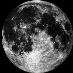
Moon Phase for May 10th at Midnight
3.5 Days Before Full Moon
=============================
Thursday Storm Recap
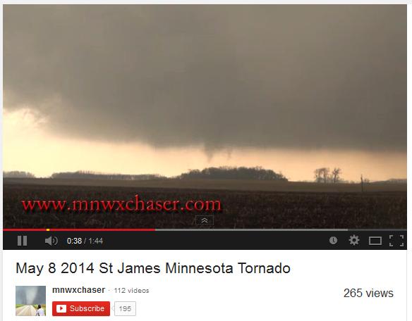
Thursday, May 8th was the 2nd tornado day in Minnesota this year with a total of 3 reports. The other tornado day in Minnesota was on March 31st, when 2 tornadoes were reported in near Minneota and St. Leo. Thanks to my good friend Bill Doms for the picture below who caught the brief tornado near St. James.
See Bill's full tornado video HERE:
You can also follow Bill on his website at www.mnwxchaser.com HERE:
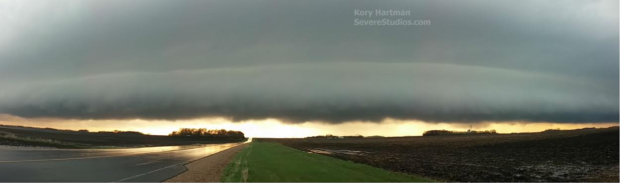
My good friend Kory Hartman snapped this picture from near Winthrop, MN on Thursday as a shelf cloud was approaching.
Check out Kory's website at SevereStudios.com HERE:
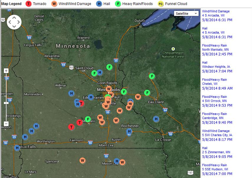
Thursday, May 8th Storm Reports
Thanks to the National Weather Service for compiling the storm reports below.
A full list and information can be found HERE:
Fishing Opener
Quiet a few anglers will be heading to area lakes this weekend to try their luck. Here's a great article from the State Climatology Office.
"Minnesota's Fishing Opener weather is typified by partly cloudy to cloudy skies, morning temperatures in the low 40's, and afternoon temperatures climbing to near 70. Three out of four years are free of measurable precipitation. A trace of snow has been reported in northern Minnesota on at least five of the last 64 fishing openers. On at least four occasions, some lakes were still frozen for the opener. Generally there is enough wind to be felt on the face, maybe enough to 'fly' a flag. Weather on Minnesota fishing opener dates is highly variable. 64 years of fishing opener weather data are summarized here to offer a glimpse of what is 'typical' and what is 'extreme'."
See the full article HERE:
(Image courtesy: Minnesota Historical Society)

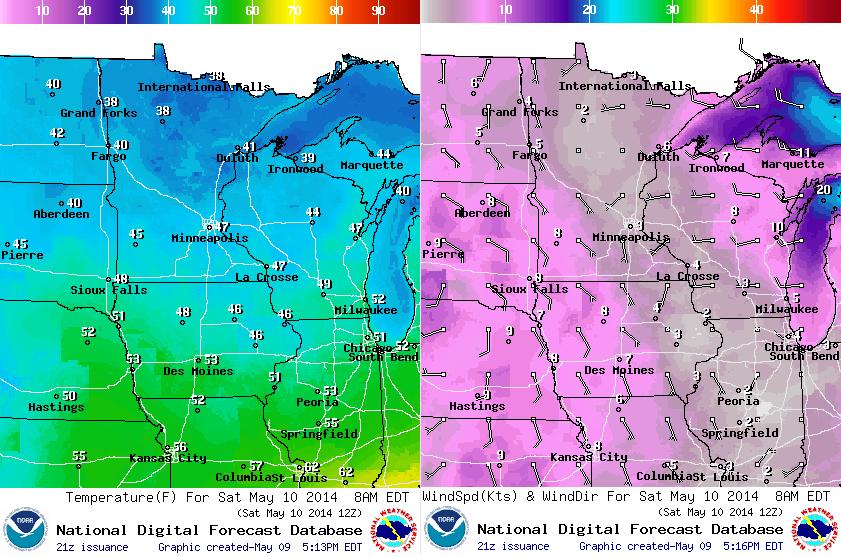
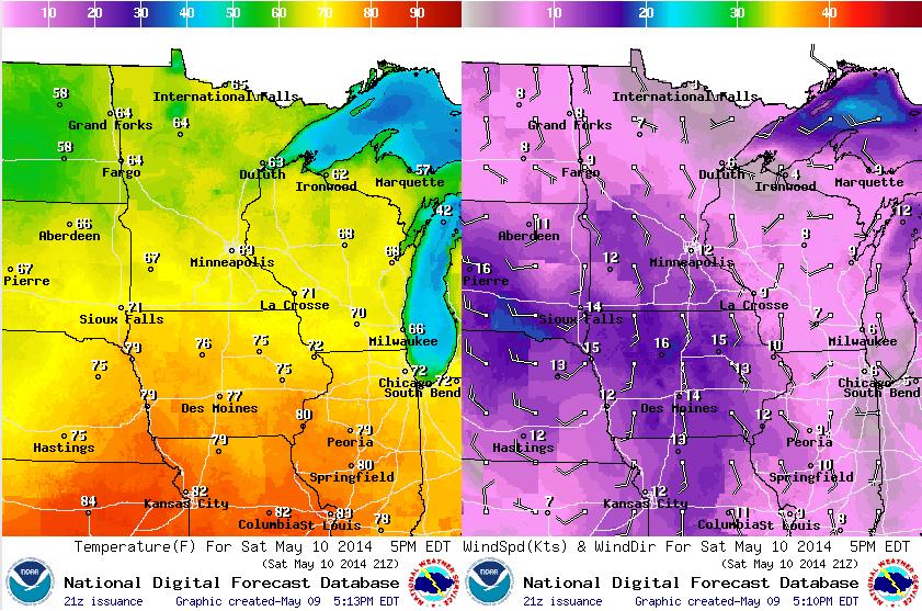
Saturday Weather Conditions
Here's a brief breakdown of temperatures and winds on Saturday
8AM Saturday
5PM Saturday
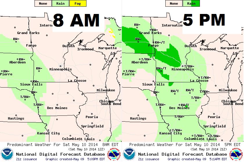
Saturday Rain Potential
After a brief break in the rain, more looks to move in later Saturday. Some spotty showers and isolated storms could move in later in the day.
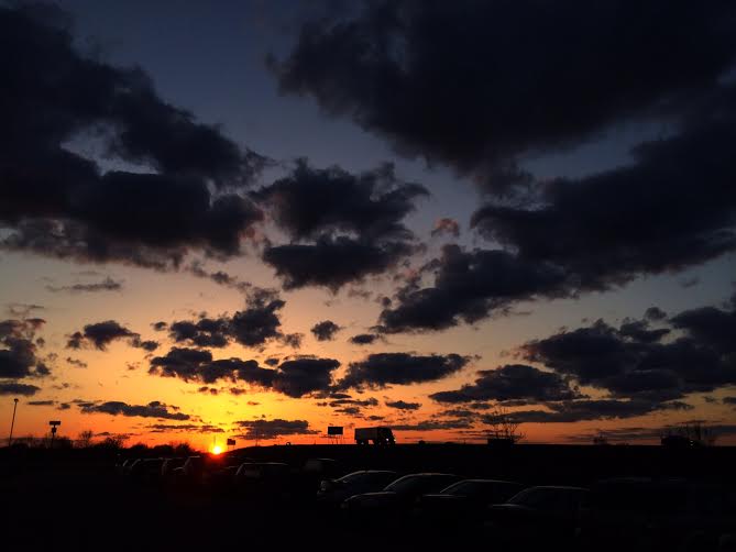
Friday Sunset
I snapped this picture on Friday evening on the northwest side of the Twin Cities. Nice to see a little sun... too bad it came late in the day.
Large Hail in Des Moines Iowa
Thanks to Jennifer Bailey for the picture below from Des Moines, IA where near golf ball size hail came down on Thursday, May 8th.

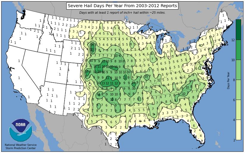
Number of Hail Days Per Year
This is an interesting graphic that shows the average number of severe hail days per year (severe hail is 1" in diameter or larger). According to NOAA's Storm Prediction Center, severe hail tends to fall in the central part of the country a little more than it does anywhere else across the U.S. with as many as 13 days per year.
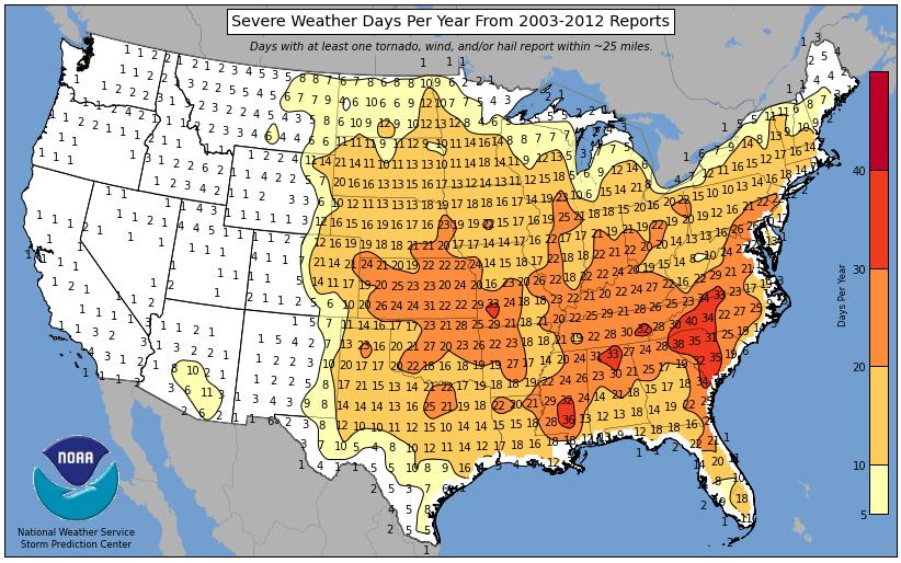
However, according to NOAA's SPC, the number of severe weather days seems to be a little higher near the Mid-Atlantic region with as many as nearly 40 severe weather days per year!
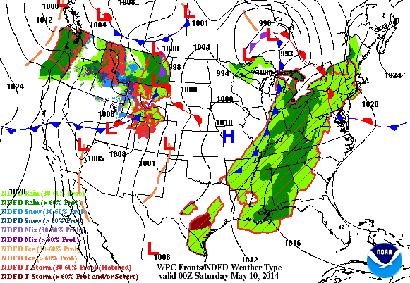
Active Weather Continues
Take a look at the loop below and note the next storm from the Northwest moving into the central part of the country. This particular storm looks to not only bring another round of heavier rainfall potential, but it could also bring severe weather chances back to parts of the Central U.S..
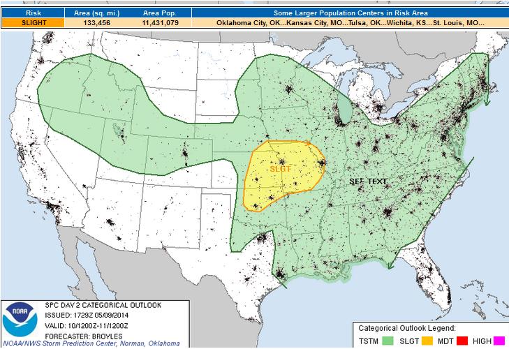
Severe Threats Continue
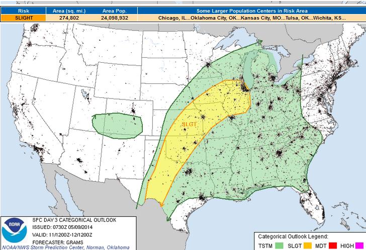
Although the severe threat doesn't appear to be extreme, some in the central U.S. will have to keep an eye on the weather this weekend. The Storm Prediction Center has issued Severe Weather Risks for both Saturday and Sunday...
Saturday Severe Threat
...SRN AND CNTRL PLAINS/MID MS VALLEY... MID-LEVEL FLOW WILL BECOME SOUTHWESTERLY ACROSS THE CNTRL U.S. SATURDAY AS AN UPPER-LEVEL TROUGH MOVES SEWD INTO THE INTERMOUNTAIN WEST. IN RESPONSE...A SFC LOW WILL RAPIDLY DEEPEN ACROSS THE CNTRL HIGH PLAINS STRENGTHENING MOISTURE ADVECTION ACROSS ERN KS SATURDAY AFTERNOON AND EVENING AS A WARM FRONT BECOMES ESTABLISHED. MOIST AND UNSTABLE AIR WILL EXIST SOUTHWEST OF THE FRONT WITH SFC DEWPOINTS ACROSS ERN KS AND MO GENERALLY RANGING FROM THE UPPER 50S F TO THE MID 60S F. THIS SHOULD RESULT IN MODERATE DESTABILIZATION DURING THE DAY ACROSS MUCH OF THE SLIGHT RISK AREA. ALTHOUGH THE MODELS ARE IN DISAGREEMENT...THE MOST LIKELY LOCATION FOR CONVECTIVE DEVELOPMENT SATURDAY AFTERNOON WOULD BE ALONG THE INSTABILITY GRADIENT FROM ECNTRL KS EWD INTO WRN MO. ADDITIONAL STORMS MAY DEVELOP EWD ACROSS CNTRL AND ERN MO LATE SATURDAY AFTERNOON. CONVECTIVE COVERAGE SHOULD MARKEDLY INCREASE DURING THE EVENING AND OVERNIGHT PERIOD FROM NE KS...SE NEB EWD ACROSS IA AND NRN MO DUE TO STRONG WARM ADVECTION ASSOCIATED WITH A STRENGTHENING LOW-LEVEL JET.
Sunday Severe Threat
...MID-MS VALLEY TO SRN PLAINS... PERVASIVE AND STRENGTHENING SWLYS AT 700 MB WILL RESULT IN AN EXPANDING EML PLUME AND ATTENDANT CAPPING INVERSION EARLY SUN...WITH INCREASINGLY RICH BOUNDARY LAYER MOISTURE GIVEN STRONG POLEWARD ADVECTION FROM THE WRN GULF. MIDDLE TO UPPER 60S SURFACE DEW POINTS SHOULD BECOME ESTABLISHED FROM THE LOWER MO VALLEY SWD...YIELDING A BROAD STRONGLY UNSTABLE AIR MASS WITH MLCAPE AOA 2500 J/KG AHEAD OF THE DRYLINE/COLD FRONT. THE NRN EXTENT OF STRONG DESTABILIZATION SHOULD BE DELIMITED BY EARLY SUN WAA-DRIVEN CONVECTION OVER PARTS OF THE LOWER MO VALLEY. SOME OF THIS ACTIVITY MAY CONTINUE E/NEWD THROUGH THE DAY WITH AN ISOLATED SEVERE RISK...BUT MORE PROBABLE SURFACE-BASED DEVELOPMENT SHOULD OCCUR WITH SWRN EXTENT WHERE GREATER INSOLATION OCCURS. STRONG CONVERGENCE ALONG THE FRONT WILL LIKELY YIELD INCREASINGLY NUMEROUS STORMS LATE AFTERNOON INTO EVENING FROM ERN KS INTO SRN IA. LARGE HAIL /SOME SIGNIFICANT/ AND A FEW TORNADOES WILL BE POSSIBLE INITIALLY. THE POTENTIAL FOR UNDERCUTTING BY THE FRONT SHOULD YIELD CLUSTER AND EVENTUAL LINEAR MODES WITH SEVERE HAIL/WIND HAZARDS PERSISTING INTO SUN NIGHT. A LARGE MCS MAY ULTIMATELY EVOLVE GIVEN THE STRENGTHENING LARGE-SCALE ASCENT DOWNSTREAM OF THE UPPER TROUGH AND BROADLY UNSTABLE WARM SECTOR.
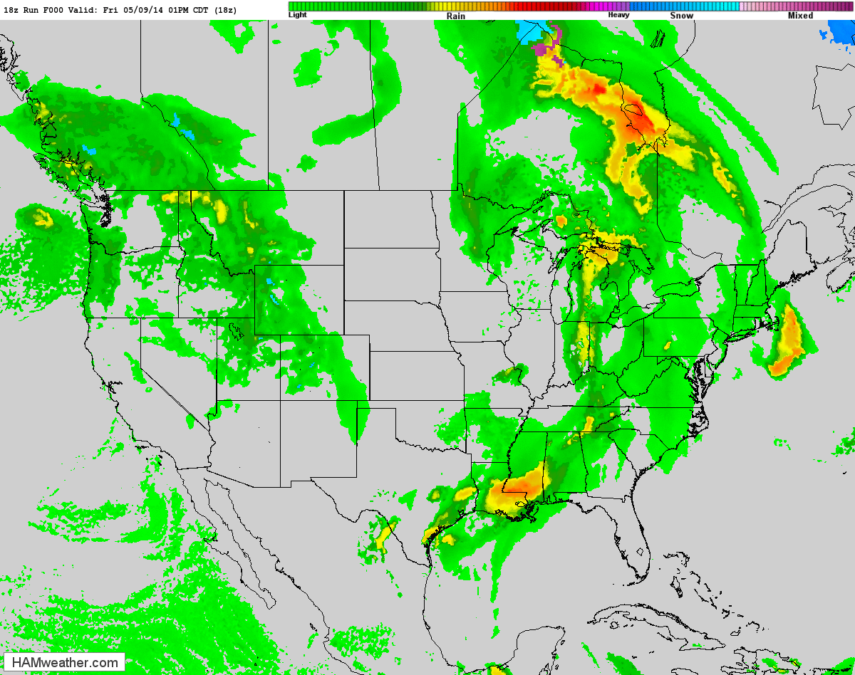
Future Radar Through Monday Night
This is a little higher resolution future radar that shows the potential precipitation through early next week. Note the blue colors showing up across parts of the Rockies and Front Range, that's snow! Winter Weather Headlines have been issued in some of these areas for the potential of 1ft. to 2ft by the end of the weekend!!
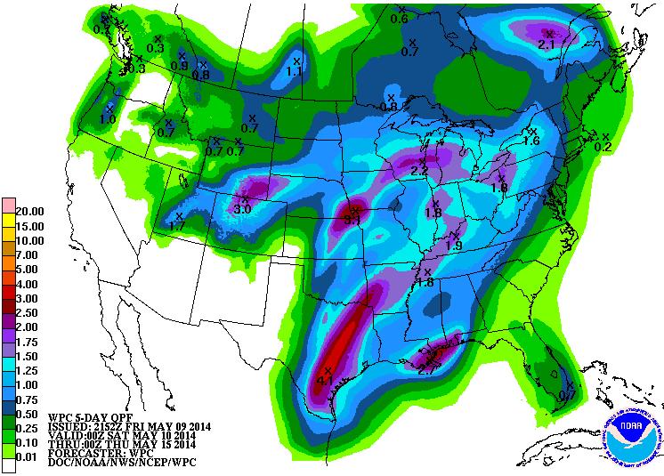
Heavy Rainfall Potential
According to NOAA's HPC, the 5 day precipitation forecast suggests another round of heavy moisture moving through the middle part of the country through early next week. Thanks to some convective moisture, some in the middle part of the country could see another 2" to 4" or more by PM Wednesday.
Snowfall Potential
Look at the snow blob over parts of the Rockies through early next week. Some of the higher elevations could see 1ft. to 2ft. !!
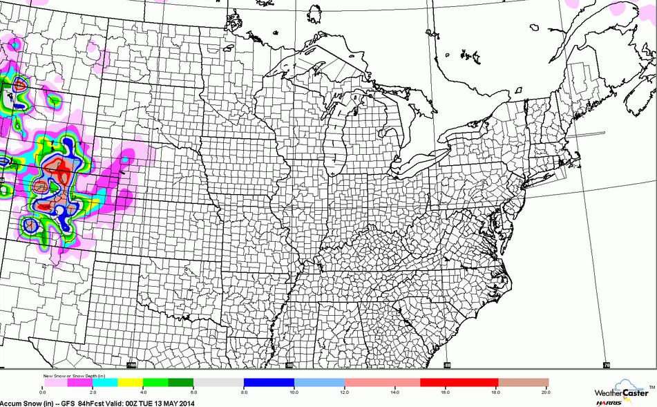
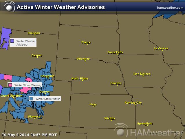
Snow Returns to the Mountains
...A POWERFUL WINTER-LIKE STORM TO IMPACT THE REGION INTO EARLY NEXT WEEK... .A STRONG ALASKAN LOW PRESSURE SYSTEM WILL DIG THROUGH THE GREAT BASIN ON SATURDAY AND SWEEP THROUGH THE CENTRAL ROCKIES SATURDAY NIGHT INTO SUNDAY. THIS COLD STORM WILL DROP SNOW LEVELS TO AROUND 5000 FEET BY SUNDAY BRINGING SIGNIFICANT SNOWFALL TO ALL BUT THE LOWER VALLEYS OF EASTERN UTAH AND WESTERN COLORADO. BY MONDAY MORNING ONE TO TWO FEET OF SNOW ARE POSSIBLE IN THE HIGHER MOUNTAINS. THE HIGHER VALLEYS COULD SEE SEVERAL INCHES OF NEW SNOW. THERE IS STILL SOME UNCERTAINTY FOR THE TIMING AND IMPACTS OF THE STORM...ESPECIALLY IN THE VALLEYS AND SOUTH OF INTERSTATE 70.
* TIMING...RAIN/SNOW MIX EXPECTED SATURDAY AFTERNOON BEFORE TURNING TO ALL SNOW AND INCREASING IN INTENSITY FROM MIDNIGHT SUNDAY ONWARDS. * SNOW ACCUMULATIONS...10 TO 20 INCHES WITH LOCALLY HIGHER AMOUNTS EXPECTED. * SNOW LEVEL...9000 FEET DROPPING TO MOUNTAIN BASES BY SUNDAY MORNING.
Thanks for checking in and have a great weekend ahead! Don't forget to follow me on Twitter @TNelsonWNTV

No comments:
Post a Comment