76 F. high in the Twin Cities Sunday.
79 F. average high on June 15.
76 F. high on June 15, 2013.
.64" rain fell Sunday at KMSP.
5.73" rain so far in June in the Twin Cities.
2.04" average rainfall for the first half of June.
1.39" rain fell in 2013 between June 1-15.
Weather Stress
"Life
isn't about waiting for the storm to pass. It's about learning how to
dance in the rain" wrote Vivian Greene. Then again some of us are
genetically incapable of dancing.
The older I get the more respect
I have for the chaotic fluid of air sloshing above our heads, and the
new forces we've inadvertently unleashed. Mother Nature is like my wife.
I feel both admiration and awe, but I don't pretend to fully understand
her either.
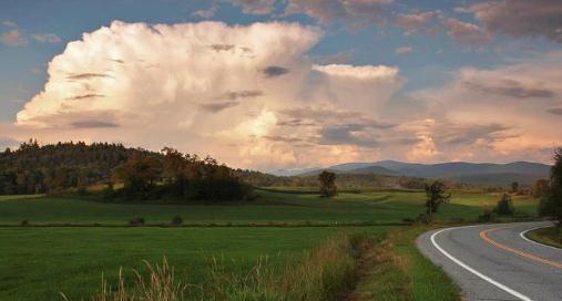
Minnesotans are talking about the weather more than
usual - if that's possible. Our weekend storm was perfectly normal, for
mid-October. Most of the metro saw 1.5 to 2.5 inches of rain but a few
communities near Willmar and Red Wing saw a month's worth of rain. Throw
in Saturday's stupefying "gravity wave" sparking 68 mph straight-line
winds, with no T-storms in the area, and you have a lost weekend.
Can we have a do-over?
Then
again the sun came out on Father's Day, and the sound of rain up at the
cabin sparked excessive napping. Quality nap-time is a gift from on
high.
A surge of hot air stalls nearby, treating us to more
scattered T-storms this week with a high probability of more downpours
and excessive rains. Expect a run of 80s, another 1-2" rain by Saturday,
and whimper-worthy dew points above 70F by midweek. Yes, we're finally
transitioning into summer.
Keep dancing.
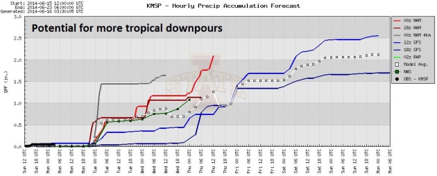
1.85" additional rain by Thursday morning (00z NAM).
2.5" additional rain next 9 days (12z ECMWF).
2.8" additional rain next 16 days (00z GFS).
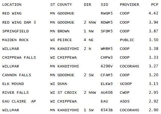
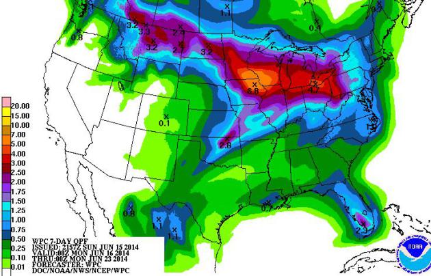
48-Hour Rainfall Amounts.
Red Wing gets the golden rain gauge award, with 4.42" of rain since
Saturday. Much of the Twin Cities metro picked up 1.5 to 2.5" of rain.
More details from the
Twin Cities NWS.
Flood Warnings Resume - More Thunderstorms in the Forecast. Here's an excerpt from a story at
The Brainerd Dispatch focusing on river flooding: "...
The
flood warning continues for the Mississippi River at Aitkin and Fort
Ripley. The river near Fort Ripley was just above flood stage at 10.3
feet and rising. It's expected to increase to 11.9 feet by Friday
causing minor flooding or rural areas. The new crest is compared to a
previous crest this time of year of 9.7 feet on June 15, 2005. In
Aitkin, the Mississippi, at 12.2 feet Sunday morning, was also rising
with minor flooding expected. The river may reach 13.8 feet by Friday
leaving some roads covered with water. The latest Aitkin crest compares
to an earlier crest of 13.3 feet on May 7, 2013..."
Another 1-3" Rain by Saturday?
Models show a significant chance of more heavy T-storms tonight, again
late Tuesday, Wednesday, with Thursday possibly the wettest day of the
week. I wouldn't be at all surprised for many communities to see a few
more inches of rain before we finally dry out over the weekend.
Midwest Monsoon Season.
At some point the sky has to run out of water, right? Not so fast. A
stalled (hot) front just south of Minnesota will trigger more T-storms
over the next 5 days; no continuous rains, but when it does decide to
rain downpours falling on saturated ground may lead to more flash
flooding. NOAA models suggest another 2-6" of rain for the Upper Midwest
by next Monday; heaviest rains falling on southeastern Minnesota.
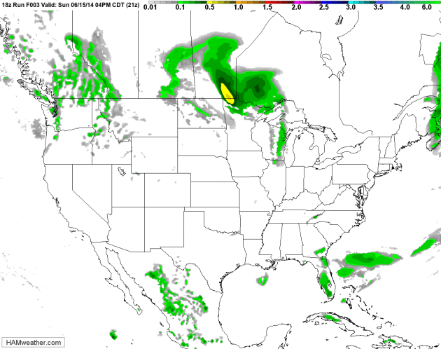
Don't Forget to Recycle Your Weather Map.
I know it appears like I just keep inserting the same Future Radar
loop, day after day, but this is the latest data, which pretty much
looks like what I showed last week. The strongest T-storms flare up over
the northern USA and Great Lakes as hot air expands northward, while
California stays dry and dusty. 12 km NAM guidance: NOAA and HAMweather.
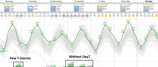
Back to the 80s.
After a chilly day on Saturday you'll finally be able to dust off the
shorts and pretend it's summer out there - a streak of 80s likely into
the weekend. In fact 90F isn't out of the question Tuesday and Wednesday
in the Twin Cities. Storms are likely by tonight, again Wednesday, with
the best chance of (numerous) T-storms coming on Thursday. Graphic:
Weatherspark.
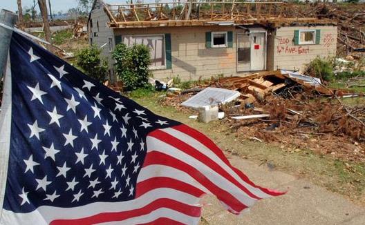
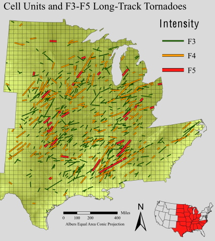
Study: Florida More Vulnerable to Twisters than Midwest.
Although frequency is lower, when tornadoes do hit Florida the damage,
injury and deathtoll is higher, due to a combination of factors:
population density and a greater percentage of mobile homes tops the
list. Here's an excerpt from the
Pensacola NewsJournal: "...
Florida
leads the country in deaths calculated per mile a tornado is on the
ground, followed by Tennessee, North Carolina, Ohio and Alabama,
according to an analysis of the past three decades by the federal
Southeast Regional Climate Center at the University of North Carolina.
That’s because Florida is No. 1 in so many factors that make tornadoes
more risky: mobile homes, the elderly and the poor, said center director
Charles Konrad II, who headed the new work. “People are just much more
vulnerable in a mobile home than they are in a regular home,” Konrad
said..."
Photo credit above: "
Florida’s
death rate of 2.4 deaths per 100 miles of tornado ground track is more
than 2 1/2 times that of Oklahoma and nearly five times that of Kansas." (Photo: Jay Reeves/AP).
Real Tornado Alley Much Farther South.
Are we seeing an eastward shift in Tornado Alley over time, or is this
just a function of tornadoes impacting more populated regions of the
USA? Here's an excerpt of an AP story at
timesdaily.com: "...
Oklahoma
and Kansas may have the reputation as tornado hot spots, but Florida
and the rest of the Southeast are far more vulnerable to killer
twisters, a new analysis shows. Florida
leads the country in deaths calculated per mile a tornado races along
the ground, followed by Tennessee, North Carolina, Ohio and Alabama,
according to an analysis of the past three decades by the federal
Southeast Regional Climate Center at the University of North Carolina.
That's because Florida is No. 1 in so many factors that make tornadoes
more risky: mobile homes, the elderly and the poor, said center director
Charles Konrad II, who headed the new work..."
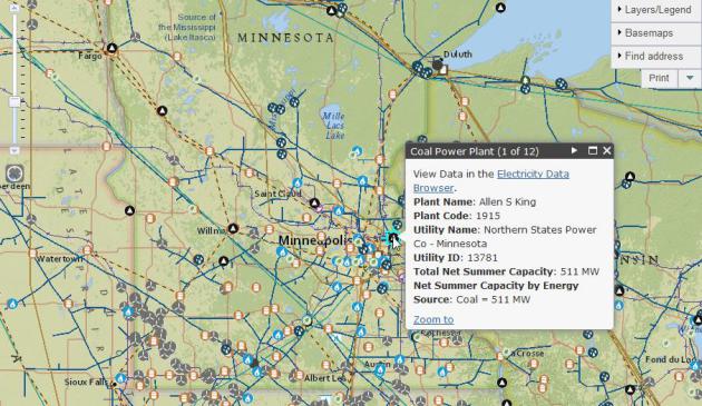
Map Shows Energy Installations In Extreme Weather's Path.
Climate Central just ran a story that caught my eye - here's a clip: "...
Are
there natural gas, oil pipelines or electricity transmission lines that
could break and leak in the flood or storm surge? Are oil and gas wells
nearby that could flood and leach hydrocarbons into the river? Those
answers can be found online using the U.S. Energy Information
Administration's interactive U.S. Energy Mapping System,
which shows all the major energy infrastructure for any given address
in the U.S. It allows anyone to look closely at what power plants,
refineries, oil wells, power lines and other installations might exist
in a place that is vulnerable to extreme weather..."
Interpreting How Climate Change Affects Extreme Events. Here's a good 2 page overview (PDF) from
NOAA. An excerpt: "
The
vulnerability of coastal regions to storm surge flooding is expected to
increase with future sea level rise and coastal development, although
this vulnerability will also depend on future storm characteristics. It
is virtually certain (99-100% chance) that the frequency and intensity
of daily heat extremes will increase, and there will be fewer cold
extremes. It is very likely the frequency of heavy precipitation events
will increase over many regions, but there is uncertainty around effects
on flooding in specific areas..."
11 Maps That Explain The U.S. Energy System.
Vox has a fascinating article that helps to put things into perspective; here's an excerpt: "...
Wind
has been rising fast, albeit from a low base. In 2008, wind provided
about 1 percent of the nation's electricity. That rose to 3.6 percent in
2012 and 4.1 percent in 2013.
There are two big reasons for that rapid growth: The federal government
has provided both tax credits and subsidies (with a big boost in the
2009 stimulus bill). What's more, many states now have laws requiring
utilities to get a certain portion of their electricity from renewables.
(One notable exception here is the Southeast.)..."
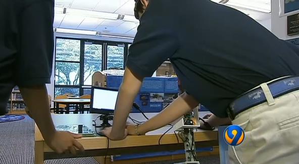
Are You Smarter Than a 6th Grader?
Our kids and grandkids will be cleaning up many of our messes, but you
can't help but be impressed with a group of 6th graders in Charlotte,
North Carolina, building apps (!) to lower the risk of flood disasters.
Here's a video and excerpt from
WSOC-TV: "
A
group of 6th graders in Charlotte created a flood level detection
device and smartphone app to alert people when there is flooding in
their neighborhood. The device is such a success the team won a regional
science completion and is headed to Washington D.C. on Monday. A state
of emergency was declared in North Carolina last summer due to summer
floods that left the western part of the state under water. It was the
worst flash flooding the area has seen in decades. This device was made
to help better prepare people for situations like this..."
TODAY: Warm sun, PM T-storms. Dew point: 62. Winds: S 15. High: 85
MONDAY NIGHT: T-storms likely, downpours possible. Low: 67
TUESDAY: Tropical with some murky sun. T-storms pop up. Dew point: 70. High: 87
WEDNESDAY: Uncomfortable. A few storms. Dew point: 72. Wake-up: 70. High: 86
THURSDAY: More numerous T-storms, downpours. Wake-up: 72. High: 81
FRIDAY: Partly sunny, T-storms up north. Wake-up: 66. High: 84
SATURDAY: Warm sun, PM storms southern Minnesota. Wake-up: 65. High: 85
SUNDAY: Blue sky, slight dip in humidity. Wake-up: 63. High: 84
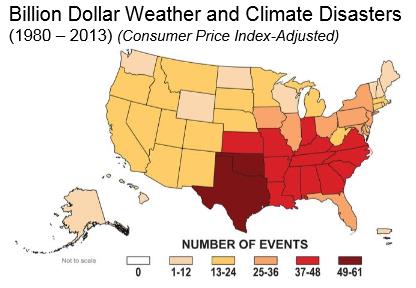
Climate Stories.
Safer Climate Disasters. The ultimate risk management challenge? An article at
Prague Post outlines the trends - here are a few nuggets that caught my eye: "...
For
example, the data for major disaster events in 2013 suggest that for
the first time in many years, more people were affected by storms than
by floods. Though it is too early to draw definitive conclusions, in the
long run storms may contribute more significantly to the global costs
of disasters, which already exceed $100 billion annually. However, we
cannot simply look to past climate events to predict future patterns.
Since 2008, for example, more than 150 million people worldwide have
been displaced by disasters that few predicted. And worse disasters will
surely occur as the changing climate interacts with other social ills
such as poverty, environmental degradation, population growth,
urbanization, and poor land use..."
Museums Tiptoe Around Climate Change.
I'm happy that there is no ambiguity about climate science at the
Minnesota Science Museum, where facts, data and trends are still
accurately respected and represented to the public. That's not the case
in other science museums around the USA. Here's a clip from
The Dallas Morning News: "...
Museums
across the country face challenges in presenting climate change to the
public at a time when the issue has become politically fraught. A series
of interviews with museum experts revealed that many factors stand in
the way of an institution’s complete and accurate portrayal of global
warming: the difficulty of presenting a complex subject in a clear,
engaging way; the rapid pace of new findings about the effects of
climate change vs. the amount of time needed to design exhibition
materials; and a desire to avoid stirring up controversy with donors,
visitors and political representatives..."
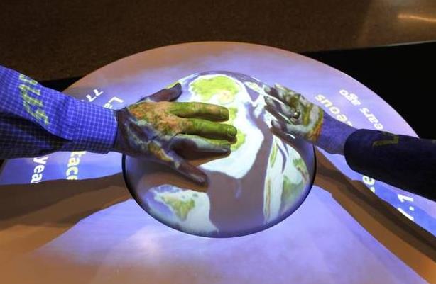
Photo credit above: File 2012/Staff Photo. "
A
globe in the Dynamic Earth Hall shows the earth over time. The museum’s
donors and its board of directors don’t have a say in museum content,
said Steve Hinkley, vice president of programs at the Perot Museum of
Nature and Science."
Global Warming Poses Threat to Southwest Water Supply. The Desert Sun has a comprehensive update on rapidly depleting reservoirs and acquifers serving the southwest USA; here's the intro: "
The
biggest reservoir in the United States is dropping 1 foot each week.
Lake Mead's rapidly sinking water level is set to reach an all-time low
in July, driven down by a 14-year drought that scientists say is one of
the most severe to hit the Colorado River in more than 1,200 years. The
water behind Hoover Dam supplies vast areas of farmland and about 25
million people in three states, and this critical reservoir stands just
40 percent full..."
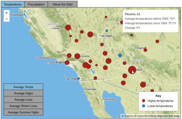
Map credit above: "
Changing
Climate in the Desert Southwest"" Climate data from weather stations
across the Southwest show that average temperatures have risen during
the past 20 years as compared to average temperatures before 1960.
Increases in average lows have been especially pronounced. Average
annual precipitation declined slightly across the region, with some
areas receiving more rain and others receiving significantly less." Source: National Climatic Data Center. Data analysis and interactive map: Robert Hopwood, Lynne Stephenson and Ian James.
Arctic Warming Taking The Edge Off Extreme Winters.
Will harsh winters like the one much of the USA just muddled through
become more common or less common in the years to come? Here's a clip
from new research at Nature Climate Change highlighted in this story at
Planet Earth Online: "...
The
jet stream is driven by the difference in temperature between the
Arctic and the tropics. The faster pace of warming in the Arctic over
recent decades has seen that gap begin to shrink. This trend is set to
continue for decades to come, and many feared that this could bring more
extreme winters in the future. But Screen's research suggests the
warming of the Arctic will instead take the edge off cold northerly
winds. 'Autumn and winter days are becoming warmer on average, and less
variable from day to day,' he says. 'Both factors reduce the chance of
extremely cold days...'
Models "Grossly Underestimate" Costs of Global Warming, Nicholas Stern Says. Could our assumptions about costs and benefits be wrong by an order of magnitude or two? Here's an excerpt from
The Sydney Morning Herald: "...
The
revised model by Dr Dietz and Professor Stern takes into account the
likelihood that the ability to generate new wealth would be affected by
extreme weather and other impacts from climate change, such as the
destruction of coastal or water infrastructure. By contrast, the current
model in use only accounts for effects on output rather than the
capital itself..."
Climate Change Will Have Broad Psychological Effects. Climate change-related PTSD? Women, children and the elderly will be most impacted. Here's an excerpt from
Imperial Valley News: "
Climate
change will have significant negative impacts on Americans’ health and
psychological well-being, due to an increase in the frequency and
severity of climate-related natural disasters and other climate-related
changes in the environment and weather. Likely effects, which will
increase as climate change’s physical impacts accelerate, include
stress, anxiety, depression and a loss of community identity, says a new
report from the American Psychological Association and ecoAmerica.
Climate change is also likely to result in an increase in post-traumatic
stress disorder and other mental health conditions because of the rise
in the number and severity of natural disasters, according to the report..."
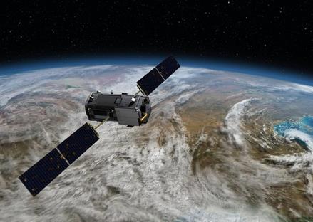
NASA To Launch First Satellite To Chart Levels of Carbon Dioxide in Atmosphere. Bloomberg has the details; here's the introduction: "
The
National Aeronautics and Space Administration plans to launch July 1
its first satellite dedicated to measuring carbon dioxide levels in
Earth's atmosphere. The $465 million Orbiting Carbon Observatory-2
(OCO-2) mission seeks to provide a more complete picture of human and
natural sources of carbon dioxide globally, as well as sinks where
carbon dioxide is absorbed. On average, the Earth's plants and oceans
absorb about half of the nearly 40 billion tons of carbon dioxide added
to the atmosphere each year from the burning of fossil fuels and other
human activities..."
Photo credit above: JPL/NASA "
NASA's Orbiting Carbon Observatory-2 (OCO-2) satellite, dedicated to measuring carbon dioxide levels in Earth's atmosphere."
Global Climate Change Is Worsening Instability And Making It Harder To Keep The Peace. Just another rant from a flaming liberal with an ax to grind? Not quite. Here's an excerpt from
a
Veteran Army Officer, Former Obama Admin Official at DOD, Truman
National Security Project Fellow and MBA Candidate at UC Berkeley Haas
School at
Huffington Post: "...
From
rising sea levels to increased frequency and intensity of extreme
weather events such as droughts, floods, and storms, to resource
scarcity, the effects of climate change are already exacerbating
security risks abroad and threatening our military installations here at
home, putting critical infrastructure at risk. In Pakistan,
record-breaking floods in 2010 inundated more than one-sixth of the
country, rendering large swaths of ungovernable territory vulnerable to
recruitment efforts from extremist groups. In Syria, the historic
five-year drought from 2006 to 2011 destroyed livelihoods for millions
of rural farmers and herders, who then sought relief in urban centers
that were not prepared to accommodate the overwhelming influx of people..."
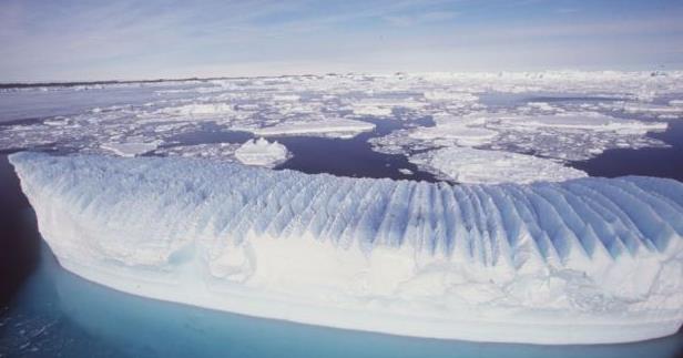
Melting Glaciers a "Climate Tipping Point", Bonn Meeting Told. Here's an excerpt from
Irish Times: "
World
leaders need to ensure that global warming is kept low enough to avoid
“pulling the plug” on vast ice shelves in Antarctica, thereby causing a
catastrophic sea level rise across the globe, a leading scientist warned
yesterday. Dr Anders Levermann,
of the Potsdam Institute for Climate Impact Research, noted last
month’s major scientific report warning that a collapse of large
sections of the west Antarctica ice shelf had already begun and was now
“unstoppable”..."
Photo credit above: "Dr
Anders Levermann told a side event at the UN climate talks in Bonn that
the Earth has entered a new era of irreversible climate change: “West
Antarctica has tipped and there isn’t anything we can do about it.” Photograph: Reuters/Australian Antarctic Division.
Climate Change Historians Will Look Back And Ask "Why Didn't They Act?" Because of greed, special interests, ignorance, inconvenience and inertia. Here's an excerpt from
The Guardian: "
Most
historians think about the past. Some study the present. Very few, it
has to be said, write about the future. But Naomi Oreskes, a Harvard
professor in the history of science, believes that our inertia in the
face of climate change will puzzle academics for centuries to come. “The
historian of the future will look back on today and ask, what happened?
Why didn’t they act on what they knew?” she says in her sunny office in
Cambridge, Massachusetts, surrounded by rocks that speak of her own
past as a geologist. Oreskes’ latest book, The Collapse of Western Civilization: A View from the Future, imagines a Chinese scholar in 2393 analysing the slow-motion disintegration of 21st-century democracies as they fail to tackle a growing environmental catastrophe..."


No comments:
Post a Comment