85 F. high in the Twin Cities Monday.
79 F. average high on June 16.
86 F. high on June 16, 2013.
.18" rain fell at KMSP International yesterday.
5.91" rain so far in June.
1.4" rain fell from June 1-16 last year.
9.82" record June rainfall (1990).
20.38" precipitation so far in 2014.
11.77" average precipitation as of June 16.
Wet and Wild
What
do I do for fun when I'm not handcuffed to the Doppler? I've been
watching the World Cup for comic relief. But who to root for, other than
the home team? I base my loyalty on two important factors: which
country has the best climate and/or best cuisine? Sorry England. Not
this year.
Anything to take our minds off the jumble of severe
storms, sauna-worthy dew points and nagging flood risk. As I've been
explaining (ad nauseum) for years when weather stalls bad things can
happen. Droughts and heat waves can amplify suddenly. If you're stuck
next to a storm or frontal boundary that's not moving the threat of
flooding goes up exponentially.
Such is the case this week, with a
warm front temporarily stalled over northern Iowa - a soggy runway for
thunderstorms to keep blossoming and redeveloping along, resulting in
another 2 to 4 inches of rain by the end of the week for some
communities. You may want to check that sump pump in the basement.
Skies
dry out a bit on Friday; the arrival of a slightly cooler, drier
airmass may set off (isolated) weekend T-storms. If it's any consolation
next week does look drier, statewide.
June rainfall is already more than 3 times the normal amount, to date. The record? 9.82 inches in 1990.
We may come close.
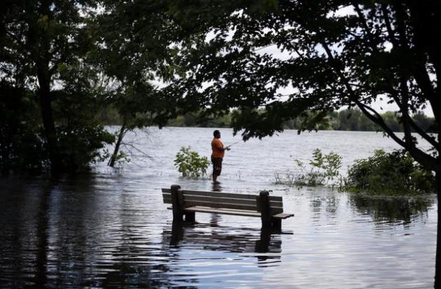
Photo credit above: "
Luckman
Nour fishes from the flooded shoreline at Lake Nokomis in Minneapolis,
Minn., Sunday, June 15, 2014. Flood waters and strong winds overturned
some sail boats and downed trees from Saturday's rain on Lake Nokomis." (AP Photo/The Star Tribune, Jerry Holt).
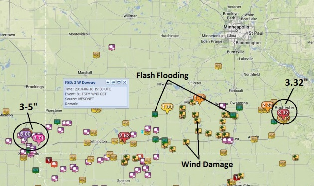
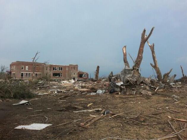
Monday Severe Outbreak.
NOAA databases show an extensive swath of wind and hail damage across
far southern Minnesota yesterday, wind gusts as high as 80-85 mph with
numerous reports of flash flooding. Over 3" fell near Rochester with
3-5" amounts over far southwestern counties. Here's a
complete list of weather-related damage.
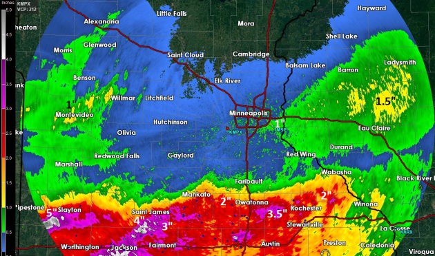
Another Severe Soaking.
The corn crop across southern Minnesota can't be in very good shape
with the recent swarms of heavy rain storms. Yesterday as much as 2-5"
of rain fell on far southern Minnesota, enough rain for serious flash
flooding in a number of communities. NWS Doppler radar estimates show
.5" of rain across most of the metro, closer to an inch over the
southeastern suburbs.
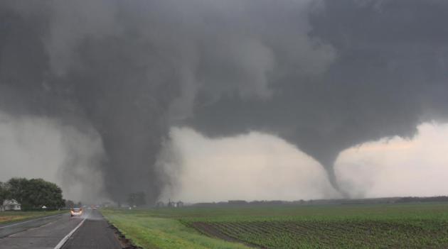
Twins.
Professional storm chaser Dustin Wilcox took this remarkable photo of
dual tornadoes, roughly 1 mile apart, near Pilger, Nebraska on Monday.
Tornado Hits Pilger, Nebraska; Numerous Injuries, At Least One Dead. Here's a clip from a story at
omaha.com: "...
NWS
meteorologist Barbara Mayes said the tornadoes that touched down were
about a mile apart. The tornadoes did not hit Stanton, but they caused
extensive damage in Pilger and some rural areas around that town of
about 380. At least one of the tornadoes lifted off the ground several
times before touching down again. "It was like God dragged two
fingernails across the the land," said Gregg Moeller of Wisner..." (Photo credit above: Krisa3G).
Tornado spotted near Clear Lake, Iowa.
Details here.
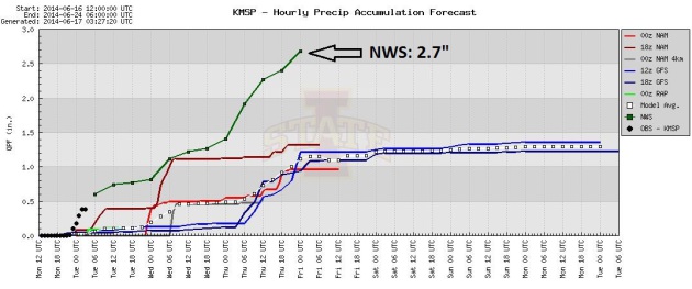
Ripe For More Soaking T-storms.
Models show another 1 to 1.5" of rain between now and Thursday, but the
official NWS forecast calls for a potential for as much as 2.7" of rain
by Thursday as T-storms flare up along a stalled frontal boundary.
Source: Iowa State.
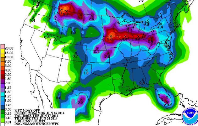
Nagging Puddle Potential.
7-Day rainfall estimates from NOAA show very significant rains in
excess of 3-5" possible from Montana into the Dakotas and much of the
Upper Midwest, Great Lakes and Ohio Valley; repeated volleys of T-storms
forming along thhe leading edge of hot, steamy air.
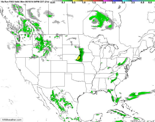
Swarms of Storms.
NOAA's 12 km NAM Future Radar product shows numerous T-storms flaring
up over the next 84 hours, heaviest rains from Minnesota into Wisconsin,
Illinois and Michigan, where flash flooding problems will persist.
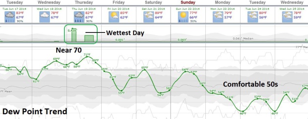
Steamy Dew Points.
Weatherspark data shows dew points in the upper 60s to nar 70F into
Thursday, followed by a cooler, drier Canadian flow next week as dew
points drop into the 50s, meaning nearly half as much water in the air.
Thursday still appears to be the wettest day of the week.
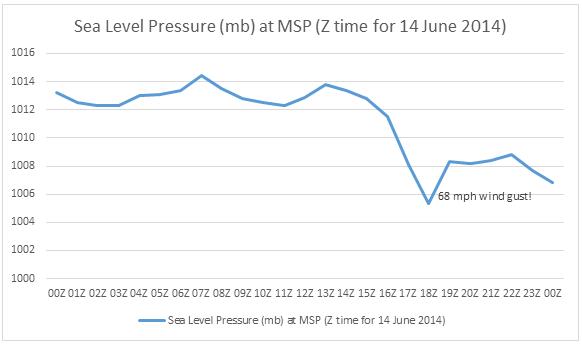
Pressure Tendencies from Saturday's "Gravity Wave".
My friend, Dan Lilledahl, who is a meteorologist at Delta Airlines in
Atlanta, sent me this graph from MSP International Airport, showing
Saturday's sudden dips and rises in atmospheric pressure. The sharp fall
in barometric pressure created a partial vacuum near the surface - air
rushing into that vacuum created several hours of powerful straight-line
winds, peaking at 68 mph at the airport.
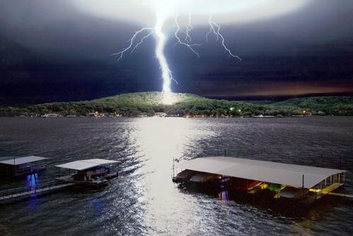
Risk of Storm Tide Topping NYC's Seawall Is 20 Times Greater Than 1800s.
AccuWeather has a story that deserves a look; here's the intro: "
An
increased storm tide flowing high enough to exceed Manhattan's seawall
defenses is 20 times greater today than it was 150 years ago, according
to a new study published in a journal of the American Geophysical Union.
The increased risk comes in large part to rising sea levels in New York
Harbor, bringing with it the risk of extensive flooding on a more
frequent basis, co-author Stefan Talke said..."
Photo credit above: "
In
this Oct. 29, 2012 file photo, streets in the Brooklyn borough of New
York are flooded under the Manhattan Bridge as a surge of seawater is
pushed into New York City by Superstorm Sandy." (AP Photo/Bebeto Matthews, File).
The Future of Hurricanes, a $10 Trillion Question.
That's the approximate dollar value of insured American properties in
the potential path of hurricanes. It's been relatively quiet since 2005,
but at some point - statistically - our luck will run out. Here's a
clip from a story from the Philadelphia Enquirer at
Florida Realtors: "...
Experts
say the lull represents the calm between the storms, and a
bleak-or-bleaker debate continues over whether the Atlantic basin will
be a busy tropical-storm brewery for perhaps the next two decades -- or
in perpetuity. With an estimated $10 trillion worth of insured property
in hurricane-target areas, the outcome is of importance not only for
coastal residents and property owners, but for every U.S. taxpayer. From
fiscal 2005 through 2013, hurricanes consumed more than $60 billion in
federal disaster money, 75 percent of all Federal Emergency Management
Agency aid, or about $500 per U.S. household. That doesn't capture the
full tally for the hybrid storm Sandy, or the estimated 24 billion tax
dollars all but lost to the U.S. Treasury by the National Flood
Insurance Program..."
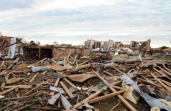
University of Alabama Researchers Show Small Changes Can Make Big Difference During Tornadoes. An article at
Insurance Journal
caught my eye - here are a few excepts focused on
(building/construction) lessons learned in the wake of killer tornadoes
from Oklahoma to Alabama: "...
From the data collected in 2011, the
researchers concluded that light-frame wood structures will not be able
to withstand a direct hit from the forces of powerful EF4 or EF5
tornadoes which produce winds stronger than 166 mph. However, based off
the three studies, it’s estimated 85 percent of the damage area left
behind by an EF4 or EF5 tornado experience winds from EF0-EF2 tornadoes,
or winds less than 135 mph....In the areas with lower wind speeds, the
root for failure of residential structures was often the garage,
according to the Moore damage assessments. When the garage door is
breached during a tornado, it typically leads to pressurization of the
garage, subsequent loss of roof over the garage and collapse of the
garage walls..."
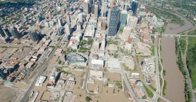
A Look at 2013 Flooding in Southern Alberta by the Numbers.
A stalled rain-maker created serious weather havoc across southern
Alberta, Canada last year at this time; here's a recap of some of the
damage and displacement from
The Province:
100,000: The estimated number of people affected by flooding. (Source: The Alberta Government)
985: Kilometres of road closed due to flood damage. (Source: The Alberta Government)
$70 million:
The amount of money the government loaded onto 56,000 prepaid debit
cards for flood evacuees. (Source: The Alberta Government)...
File photo above:
Calgary Herald.
How Dad's Improve Their Kids' Lives, According To Science.
Yes, my father looks younger than I do, which fills me with a wide
range of emotions, mostly envy and admiration. I wish I got more of
THOSE genes. I'm don't pretend to be a super-father - I'm still learning
on the job, a job for which there is no manual or tutorial. Here's an
excerpt from an interesting article at
Vox: "
We
all think we know a lot about fathers and what they do for their kids,
but what do we really know?" he told me in a recent interview. A science
writer who'd published books on mental illness and space exploration, Raeburn did a comprehensive survey of scientific research on fatherhood. The result is his newest book, Do Fathers Matter?
Raeburn found that fathers play a huge role in their children's lives,
even before they're born. "Fathers have much more effect on children
than even I would have guessed — and I was biased in favor of fathers to
start with," he said..."
Rowing 2,400 Miles from Monterrey to Hawaii? This seems like a good idea on paper, but in reality? Check out the story at
The San Francisco Chronicle.
Why You Should Only Spend $500 On Your Next TV.
With 4K OLED right around the corner I'm feeling even more
technologically inadequate than usual. 1080 HDTV is so 2007. Here's an
excerpt from
Wired: "
Welcome
to the awkward HDTV transitional phase. If you need to buy a new TV
right now, what do you do? Bet big on an UltraHD TV and wait for 4K
content to become as plentiful as HD? Splurge on an early-generation
OLED, then kick yourself in two years when they become more affordable?
Buy a massive, high-end 1080p set, then regret it when everybody flocks
to your buddy’s house to watch Super Bowl 50 on his 4K OLED? At this
moment, your smartest move is to go cheap..."
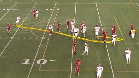
NFL May Track Footballs Using Magnetic Fields.
Did the ball penetrate into the end zone? Sometimes it's tough to tell,
even with instant-replay. Here's an excerpt of some new technology that
may remove some of the guesswork, courtesy of
Gizmag: "
Have
you ever wondered how game officials know if the football has passed
the goal line, in situations where it's hidden under a pile-up of
players? Well, sometimes they don't know, and they just have to hope
that it isn't moved as the players get up. A team of researchers from
North Carolina State University, Carnegie Mellon University and Disney
Research, however, may have a solution. They're developing a method of
tracking a football via low-frequency magnetic fields..."
Sports-Loving Dog Watching The World Cup. Check out Georges on
YouTube, who doesn't seem to mind who wins or loses. I wish I could get this excited.
TODAY: Sticky sun, few T-storms. Dew point: 69. Winds: SE 10. High: 86
TUESDAY NIGHT: More T-storms, locally heavy rain. Low: 71
WEDNESDAY: Muggy, more T-storms pop up late. High: 87
THURSDAY: More numerous T-storms. Flash flooding? Wake-up: 70. High: 82
FRIDAY: Partly sunny, a bit drier. Wake-up: 69. High: 86
SATURDAY: Warm sun, isolated late-day storm. Wake-up: 68. High: 85
SUNDAY: Sunny start, late-day thunder. Wake-up: 66. High: near 80
MONDAY: Sunny, less humid. Dew point: 62. Wake-up: 63. High: 81
Climate Stories...
Climate Change and National Security: A House Divided.
Buried deep in The National Defense Authorization Act (HR 4435 is an
ammendment that specifically prevents the military from factoring
climate change into future readiness plans and strategies. Here's a clip
from
The Houston Chronicle: "...
Nestled
in Title III, Subtitle B, Section 320A is a “prohibition on use of
funds to implement certain climate change assessments and reports.” It
reads:
None of the funds authorized to be
appropriated or otherwise made available by this Act may be used to
implement the United States Global Change Research Program National
Climate Assessment, the Intergovernmental Panel on Climate Change’s
Fifth Assessment Report, the United Nation’s Agenda 21 sustainable
development plan, or the May 2013 Technical Update of the Social Cost of
Carbon for Regulatory Impact Analysis Under Executive Order No. 12866.
This
amendment, in effect, keeps the Department of Defense from preparing
for or performing any military activities that include any construction
related to climate change. For example, it precludes protecting
facilities such as the Norfolk Naval Base from changes in sea level..."
New Economic Model Shows Risks from Climate Change are Bigger Than Previously Estimated. Here's the introduction to a story at
The London School of Economics and Political Science: "
A
new version of a standard economic model shows that the risks from
unchecked climate change are bigger than previously estimated and
strengthens the case for strong cuts in greenhouse gas emissions, according to a new paper by Simon Dietz and Nicholas Stern which is published today (16 June 2014).
The paper, which has been peer reviewed and accepted for publication in
a forthcoming issue of ‘The Economic Journal’, found that living
standards could even start to decline later this century unless the
growth in annual emissions of greenhouse gases is checked..."


No comments:
Post a Comment