85 F. high in the Twin Cities Friday.
80 F. average high on June 20.
91 F. high on June 20, 2013.
Trace of rain at MSP International yesterday.
.67" additional rain predicted by Monday evening (00z NAM model).
Waterlogged Solstice
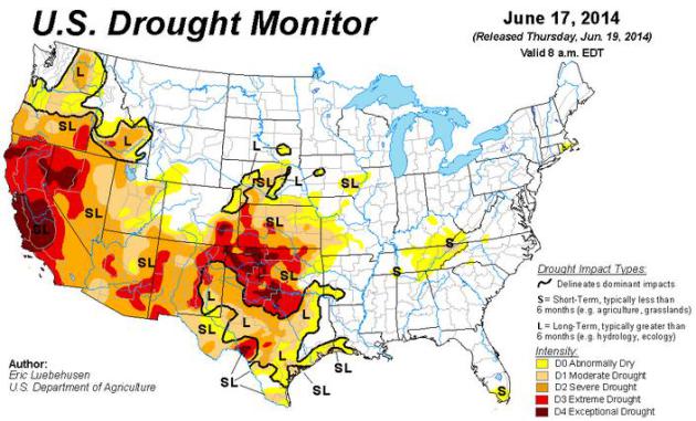
Breaking
news: for the first time in 3 years no portion of Minnesota is in
drought! No kidding. With little warning the weather pendulum has swung
in the opposite direction.
To try and put this into perspective
much of Minnesota has already picked up a year's worth of precipitation.
At 25.23 inches 2014 is the wettest year, to date, since modern-day
records were started in 1871. What's also impressive (at least for geeky
meteorologists) is the size of the area impacted by flooding. Most
summer flash floods strike just a few counties. This week's inundation
flooded 35 of Minnesota's 87 counties; the kind of expansive soaking
you'd expect in April or October - not a couple days away from the
Summer Solstice.
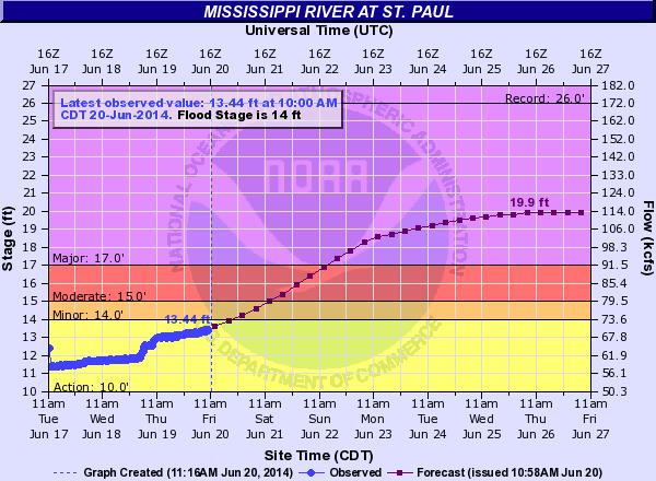
Major flooding is expected next week on the
Mississippi near St. Paul. The forecast crest of 19.9 feet would be the
highest June crest on record. Good grief.
Expect warm sun today;
mid-80s may lure you onto an overflowing lake today. Just don't create a
wake. A T-storm could bubble up by evening - maybe 1-2 inches from
T-storms Sunday and Monday; more storms late next week. At this rate we
should easily break the record for wettest June (11.67 inches in 1874).
What a year huh?
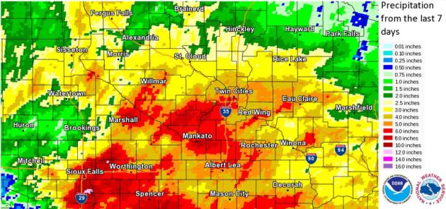
5-8 Weeks Worth Of Rain Last Week South Metro and much of Southern Minnesota.
Here are rainfall amounts for the last 7 days according to NOAA, as
much as 4-6" south metro, with as much as 10"+ near Marshall and
Worthington.
Record June Flood Crest For Mississippi at St. Paul? The record crest in St. Paul was 26 feet in April of 1965, but the
record June crest is 16.8 feet on June 2, 1908. Based on the
latest forecast
from NOAA's North Central River Forecast Center the Mississippi may
crest nearly 3 feet above that stage the latter half of next week.
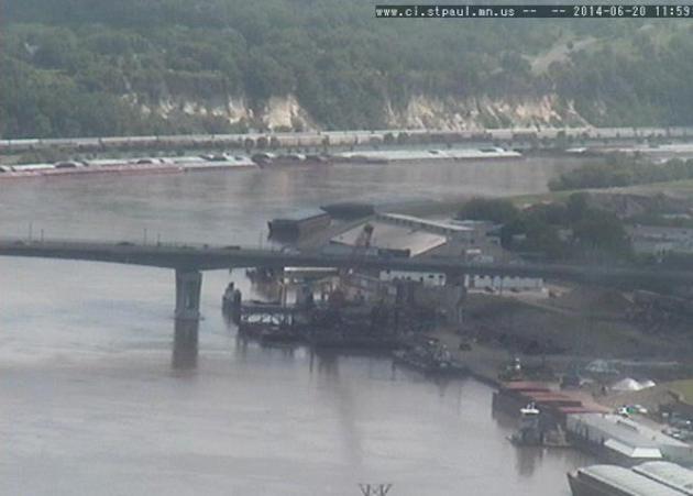
Flood Preparation in St. Paul. Here's a link to
The City of St. Paul, which has the latest crest forecasts, webcams, impacts and implications for road and park closures into next week:
Flood Impacts
| 14 feet | Minor Flood Stage |
| 14 feet | Water Street Closed |
| 14 feet | Lilydale Park area begins to become submerged |
| 15 feet | Moderate Flood Stage |
| 17 feet | Major Flood Stage |
| 17 feet | Secondary flood walls are deployed at St. Paul airport |
| 17.5 feet | Harriet Island begins to become submerged |
| 18 feet | Shepard / Warner Road may become impassable |
Historic Heavy Rainfall.
Dr. Mark Seeley points out something that caught my eye as well: the
expansive aerial coverage of area that received excessive rains in
recent weeks, especially the last week. Most flash flood events are
confined to a county or two; but at least 35 Minnesota counties have
been impacted by recent record rains. Here's an excerpt of this week's
Minnesota WeatherTalk: "...
For
the first time since July of 2011 there is no spot on the Minnesota
landscape designated to be in drought! I think we all know why, another
historically wet month of June is upon us. Four of the last five Junes
have brought record setting rainfalls to some parts of the state. The
most remarkable feature of this June is how widespread (geographically)
these record-setting rainfalls have been..."
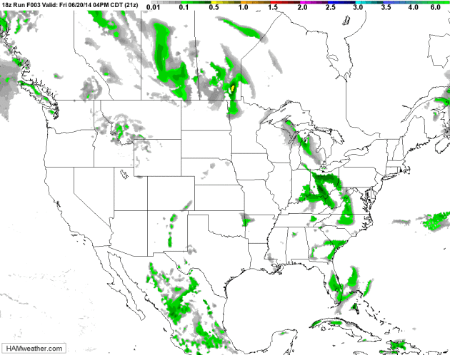
One More Sloppy Frontal Passage.
12 km. NAM Future Radar shows a few isolated T-storms later today, a
better chance of scattered storms Sunday as the leading edge of
(slightly) cooler, drier air pushes across the Upper Midwest. Dew points
drop into the upper 50s by the middle of next week, about as
comfortable as its going to get the next 1-2 weeks. Source: NOAA and
HAMweather.
Extended Outlook.
At the rate we're going we have a 60-70% chance of breaking the
all-time June rainfall record for the Twin Cities (11.64" set in 1874).
Half an inch of rain is possible Sunday, another 1 to 1.5" the end of
next week and next weekend, falling on top of the 10.76" that's already
accumulated so far. European (ECMWF) data suggests a slight dip in
temperature and dew point late Monday into Wednesday, and then back into
a hot, tropical (thundery) pattern the end of next week as T-storms
return.
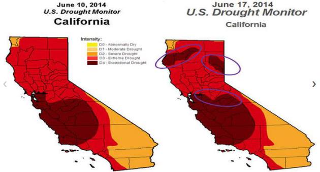
California's Drought Getting Even Worse, Experts Say.
While we hold our breath through the wettest year ever recorded,
California continues to wither. Here's an excerpt of an update from
The Los Angeles Times: "...
Exceptional"
drought conditions have spread in Central California since a week ago,
weather officials said. Areas in Northern California have also moved
into this category since last week, according to the U.S. Drought
Monitor. Almost 33% of the state faces exceptional conditions. About 25%
of the state faced those conditions last week. Every part of California
remains in what is considered severe drought. A year ago, no part of
the state was in exceptional drought conditions, the weather service
said..."
Airliners Become Weathermen as Sensors Upend Forecasting. Yes, the Internet-of-Things has the potential to revolutionize weather forecasting, as reported at
Bloomberg; here's an excerpt: "...
The
number of aircraft sending the temperature and wind data has grown
gradually and now as many as 500,000 observations a day are captured around the world, mostly in North America, Europe and parts of Asia, according to the U.S. National Oceanographic and Atmospheric Administration.
While no one has quantified the benefits, even small advancements count
when weather causes about one-third of all flight delays. Total delays
cost airlines more than $8 billion in 2007, according to Transportation
Department data..."
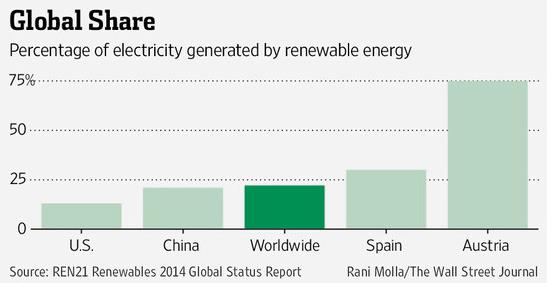
World Gets 22% of Electricity from Renewables.
That's a higher number than I was expecting. In the U.S. the number is
closer to 13%, but it continues to rise, according to an article at
The Wall Street Journal; here's a clip: "
The Renewables 2014 Global Status Report released
earlier this month has good news for the environment, namely that an
estimated 22.1% of the world’s electricity was generated from renewable
sources in 2013. That percentage is expected to rise as countries across
the globe pour money and resources into alternative, clean energy..."
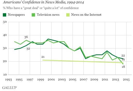
Confidence In Television News Dips to New Low. TVSpy has the story; here's an excerpt: "The
percentage of Americans who have a “great deal” or “quite a lot” of
confidence in the news media is at a record low, according to a new Gallup poll. Confidence in television news is at an all time low of only 18%, lower than both newspapers (22%) and Internet news (19%)..."
This Is Why The Midwest Is Still #1. In spite of the monsoon summer rains and harsh winters there's something to be said for living in "fly-over land".
Huffington Post has a list; here's an excerpt:
"Huzzah
for America's Middle West! Its heartland. Its breadbasket. Home of open
skies, neat rows of corn and more lakes than you can imagine. Yes,
"science" is a loose term here. We merely jumped at the chance to
explain precisely what makes the Midwestern region so wonderful,
according to certain probably unbiased sources. Did we go overboard?
Does it matter? Here are 12 reasons to love the Midwest even more..."
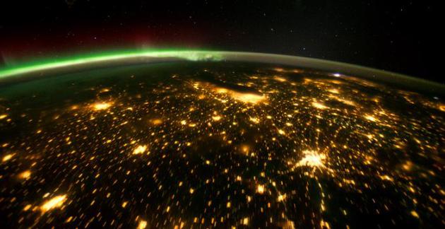
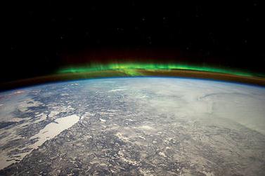
Image credit: NASA's Earth Observatory.
TODAY: Summer Solstice: 5:51AM. Some AM sun, isolated T-storm possible. Winds: SW 5-10. High: 86
SATURDAY NIGHT: Humid with a risk of a T-storm. Low: 69
SUNDAY: Humid, few showers T-storms likely. Dew point: 68. High: 81
MONDAY: Passing shower, turning slightly cooler. Wake-up: 68. High: 81
TUESDAY: Sunny start, PM showers north. Wake-up: 62. High: 79
WEDNESDAY: Partly sunny, probably dry. A bit more comfortable. Wake-up: 59. High: 81
THURSDAY: Muggy, more T-storms in the area. Wake-up: 60. HIgh: 83
FRIDAY: Hot sticky sun, a few pop-up storms. Wake-up: 70. High: 88
Climate Stories...
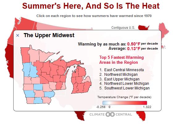
Summertime Blues. U.S. Seeing Red as Temps Rise.
The long-term temperature trends, with a few exceptions, are warmer for
the vast majority of the United States. Here's an excerpt from
Climate Central: "...
The summer solstice
is right around the corner this Saturday and temperatures around the
U.S. have started to rise to the occasion. But it’s not just a warmup
from spring to summer that’s occurring: summer temperatures have been
steadily rising since 1970. On average, temperatures have increased at a
rate of about 0.4°F per decade in the contiguous U.S. since 1970, or
nearly 2°F overall. But some areas have been warming much faster, and
others more slowly. The fastest warming “climate divisions,” or
localized areas within regions, are in southern California and Nevada in
the western region. There, temperatures have risen by as much as 1.32°F
per decade, or more than 5°F overall since 1970..."
The New Environmentalism Will Lead Us To Disaster. Is there such a thing as a "Good Anthropocene"? Here's a snippet of an Op-Ed at
Scientific American: "...
Some
climate science deniers believe only God can change the climate;
ecopragmatists, by contrast, see humans as “the god species.” Here is
what the god species and this kind of thinking are certain to give us:
an atmosphere with 500 ppm of CO2 (probably closer to 700 ppm) and a
climate that is hot, sticky and chaotic. It will indeed take omnipotence
to fix the problem without calamity. For those who prefer orthodox
climate science, such unbounded optimism is dangerous, wishful thinking." (Image credit: NASA).


No comments:
Post a Comment