74 F. high in the Twin Cities Thursday.
80 F. average high on June 19.
85 F. high on June 19, 2013.
4.01" rain fell yesterday as of 8 PM, a record (old record was 2.44" in 1954).
10.64" rain so far in June.
2.64" average rainfall for June, to date.
25.11" precipitation at KMSP so far in 2014.
12.22" average precipitation since January 1, to date.
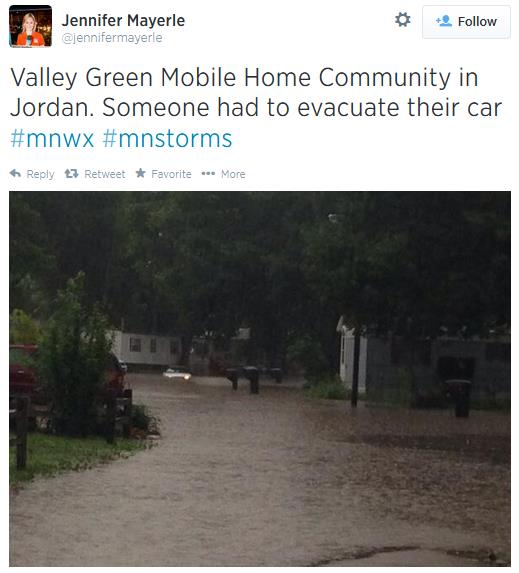
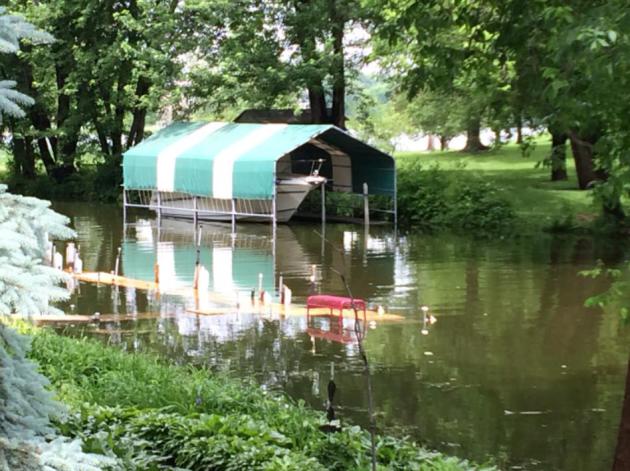
Jungles of Minnesota
I
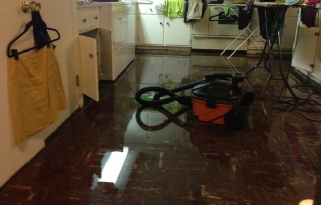
miss the drought. Yes, I know it was bad for farmers, but I'm not sure
this is any better. I feel your pain, spending much of yesterday wading
around in my flooded basement, using words I now regret.
3.95
inches fell as of mid afternoon, making Thursday the wettest day since
2005; the 8th wettest since 1871. MSP has picked up over 10 inches so
far in June - over 25 inches for 2014 (a year's worth of rain), making
this the wettest start to any year since modern-day records were started
in 1871.
From Polar Vortex to Tropical Gusher - we just can't seem to catch a break.
An
overnight MCS (meso-convective system), a nearly statewide swarm of
T-storms, pumped out rain-cooled air which triggered additional waves of
storms in its wake. This "train-echo" effect resulted in some half foot
rainfall amounts in the south metro; 6 weeks of rain in 12 hours.
It's
not over yet. A few more squall lines of T-storms juiced with tropical
rains linger into Sunday; then drying out from Monday into Thursday with
a welcome dip in dew point.
Here's another classic example of
weather getting stuck for days or weeks at a time. And when weather
stalls it often leads the news.
As for me? A 5th floor apartment is sounding good.
STATE CLIMATOLOGY OFFICE - DNR ECOLOGICAL AND WATER RESOURCES --- FOR IMMEDIATE RELEASE JUNE 19, 2014
Subject: Wet June records for the Twin Cities.
June
2014 has been memorable for the widespread rain events across Minnesota
and will finish as one of the wettest Junes on record in the Twin
Cities. June 19 is also the wettest calendar day in the Twin Cities in
nine years.
So far the Twin Cities International Airport has
recorded 4.01 inches of rain as of 8pm on June 19th. This is enough to
be the 8th wettest calendar day on record in the Twin Cities with
records going back to 1871. The highest calendar day rainfall total is
9.15 inches on July 23, 1987 in the "Super Storm." The last time there
was a rainfall total on a calendar day higher than June 19th in the
Twin Cites was 4.61 inches on October 4, 2005.
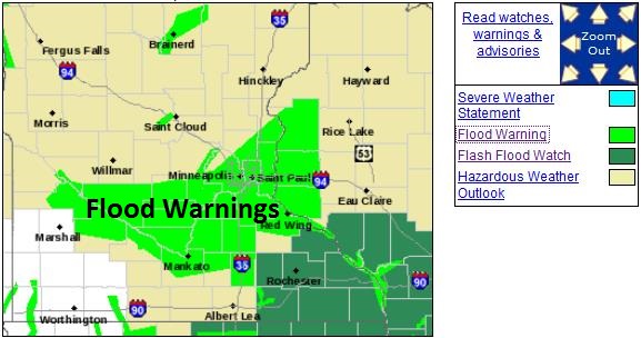
Flood Warnings Still Posted.
NOAA
has extended flood warnings for stream and river flooding for a wide
swath of real estate over southern and eastern central Minnesota and
western Wisconsin. In fact I can't remember seeing so many counties
under flood warnings, certainly in June.
Details:
THE NATIONAL WEATHER SERVICE IN THE TWIN CITIES HAS EXTENDED THE

* FLOOD WARNING FOR...
  DAKOTA COUNTY IN EAST CENTRAL MINNESOTA...
  EASTERN SCOTT COUNTY IN EAST CENTRAL MINNESOTA...
  HENNEPIN COUNTY IN EAST CENTRAL MINNESOTA...
  NORTHERN CARVER COUNTY IN EAST CENTRAL MINNESOTA...
  NORTHERN GOODHUE COUNTY IN SOUTHEAST MINNESOTA...
  NORTHERN RICE COUNTY IN SOUTH CENTRAL MINNESOTA...
  PIERCE COUNTY IN WEST CENTRAL WISCONSIN...
  POLK COUNTY IN NORTHWEST WISCONSIN...
  RAMSEY COUNTY IN EAST CENTRAL MINNESOTA...
  SOUTHEASTERN ANOKA COUNTY IN EAST CENTRAL MINNESOTA...
  SOUTHEASTERN CHISAGO COUNTY IN EAST CENTRAL MINNESOTA...
  ST. CROIX COUNTY IN WEST CENTRAL WISCONSIN...
  WASHINGTON COUNTY IN EAST CENTRAL MINNESOTA...

* UNTIL 630 PM CDT FRIDAY

* AT 506 PM CDT...EMERGENCY MANAGEMENT REPORTED SEVERAL AREA
  ROADWAYS REMAIN FLOODED.  SLOW MOVING THUNDERSTORMS WITH HEAVY
  RAINFALL ARE ONCE AGAIN BEGINNING TO MOVE ACROSS THE TWIN CITIES
  METRO AREA.  AN INCH OR TWO OF ADDITINAL RAIN IS POSSIBLE WITH THE
  THUNDERSTORM ACTIVITY THROUGH THE EVENING.

* RUNOFF FROM THIS EXCESSIVE RAINFALL WILL CAUSE FLOODING TO OCCUR.
  SOME LOCATIONS THAT WILL EXPERIENCE FLOODING INCLUDE...AMERY...
  BALSAM LAKE...BLOOMINGTON...BURNSVILLE...CENTER CITY...EDEN
  PRAIRIE...ELLSWORTH...HUDSON...LAKE MINNETONKA...NEW RICHMOND...
  PLYMOUTH...RED WING...RIVER FALLS...SHAKOPEE...ST LOUIS PARK...
  AFTON STATE PARK...BLAINE...BROOKLYN CENTER...BROOKLYN PARK...
  CANNON FALLS...CHANHASSEN...CHASKA...COON RAPIDS...CRYSTAL...
  EAGAN...EDINA AND EXCELSIOR.

PRECAUTIONARY/PREPAREDNESS ACTIONS...

EXCESSIVE RUNOFF FROM HEAVY RAINFALL WILL CAUSE FLOODING OF SMALL
CREEKS AND STREAMS...HIGHWAYS AND UNDERPASSES. ADDITIONALLY...
COUNTRY ROADS AND FARMLANDS ALONG THE BANKS OF CREEKS...STREAMS AND
OTHER LOW LYING AREAS ARE SUBJECT TO FLOODING.

FLOODING IS OCCURRING OR IS IMMINENT. MOST FLOOD RELATED DEATHS OCCUR
IN AUTOMOBILES. DO NOT ATTEMPT TO CROSS WATER COVERED BRIDGES...
DIPS... OR LOW WATER CROSSINGS. NEVER TRY TO CROSS A FLOWING
STREAM... EVEN A SMALL ONE...ON FOOT OR IN A VEHICLE.
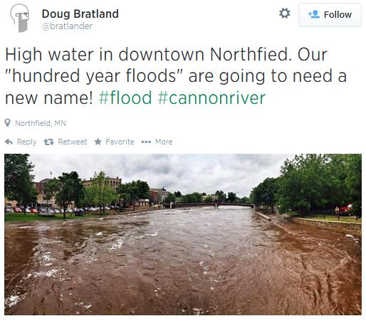
 Most 24-Hour Rain Since October 4, 2005
.
On that day in early October 4.61" of rain fell on the Twin Cities.
Days with 3"+ rains at MSP are relatively rare; yesterday was the 9th
such day since 1938.
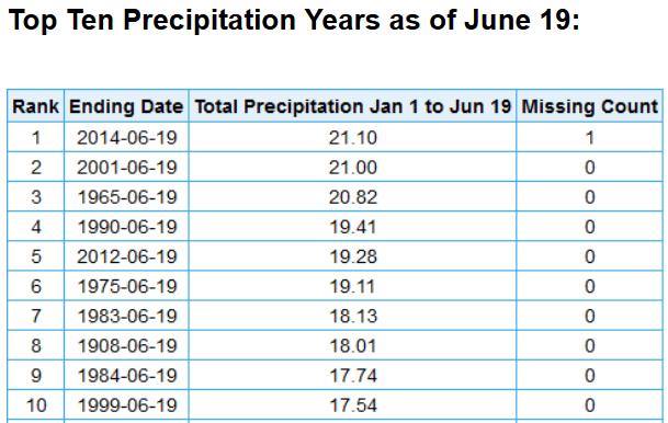
Welcome To The Wettest Year, To Date, Since 1871.
Here are numbers from NOAA, showing 21.10" as of late afternoon
yesterday in the Twin Cities, just passing 2001 as the wettest year (as
of June 19). What's vaguely interesting to me: 7 out of the 10 wettest
years have been since 1983. Source: NOAA.
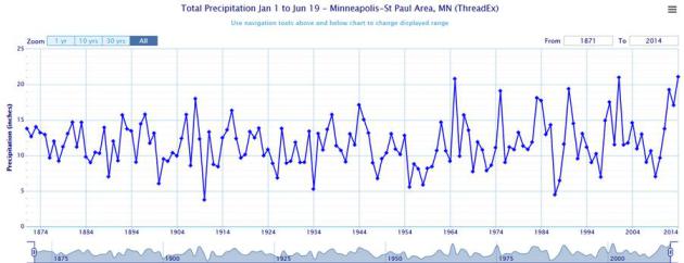
Tracking The Trends.
Is Minnesota getting wetter, or is that perception vs. reality? If you
look at the annual precipitation totals map above (January 1 - June 19)
there's no apparent trend toward wetter or drier. But the amplitude of
the graph, the "peaks and valleys" seem to have increased since the 60s,
as we oscillate back and forth from drought to flood.
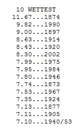
Second Wettest June on Record.
At the rate we're going the all-time record of 11.67" rain set in 1874
is in peril. We could, in theory, be living through the wettest June on
record as early as Sunday as the next front sloshes through. More on wet
Junes in the Twin Cities from the
Minnesota DNR.
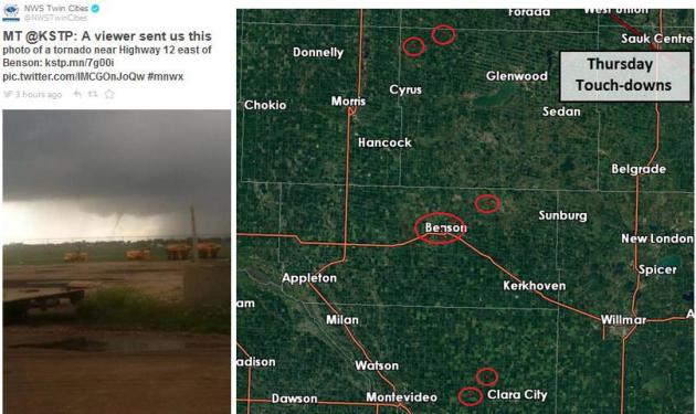
Thursday Tornadoes.
I count as many as 9 separate tornado touchdowns Thursday late
afternoon from as many as 3 supercell thunderstorms that sprouted in
response to sunshine, strong heating and lingering instability, most in
the vicinity of Benson. There were reports of minor damage in the area.
NOAA has details
here.
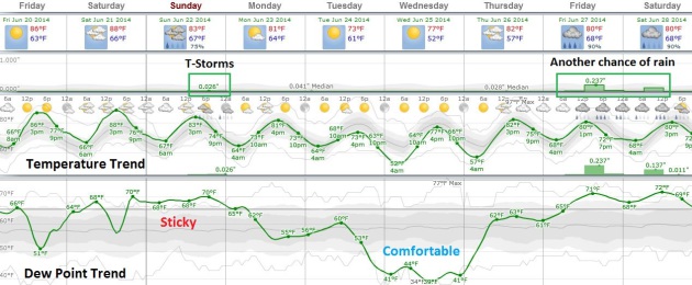
Few Storms Saturday Night & Sunday - Drier Next Week.
A warm, sticky weekend is shaping up with dew points near 70F, but
Canadian air pushes south next week, a brief spell of very comfortable
weather by the middle of next week. Long-range guidance suggests more
showers and T-storms by the end of next week.
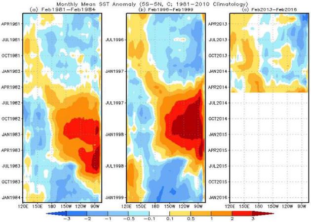
El Nino Evolution: Comparisons to 1982-83 and 1997-98.
It's still too early to know whether we're going to see a mild,
moderate or severe El Nino event. What's interesting, at least to me, is
how global warmth records are being broken (warmest spring worldwide
according to JMA, warmest May based on preliminary NASA data), so even
without a warm phase in the Pacific Ocean 2014 is setting up to be a
year to rival 2010, the previous record for the warmest year, worldwide,
on record. Map above: NOAA.
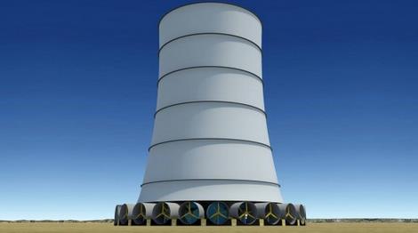
Solar Wind Energy's Downdraft Tower Generates It's Own Wind All Year Round.
Here's another amazing example of mashed-up technology that might be
able to improve the reliability of renewables going forward; an excerpt
from a story at
Gizmag: "
When
we think of wind power, we generally think of huge wind turbines
sitting high atop towers where they can take advantage of the higher
wind speeds. But Maryland-based Solar Wind Energy, Inc. is looking to
turn wind power on its head with the Solar Wind Downdraft Tower, which
places turbines at the base of a tower and generates its own wind to
turn them. Described by the company as the first hybrid solar-wind
renewable energy technology in the renewable energy market, the tower at
the center of the system generates a downdraft that drives the wind
turbines positioned around its base..."
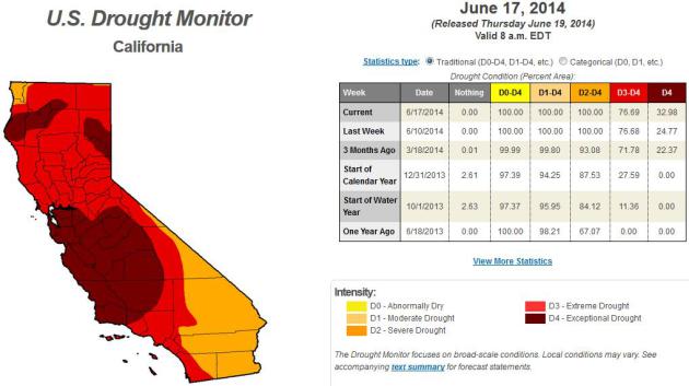
Why Californian's Will Soon Be Drinking Their Own Pee. O.K. I'm suddenly feeling better about my soggy basement, after reading this Eric Holthaus story at
The Atlantic Citylab; here's an excerpt: "...
The
conclusion here is easy: If drinking purified pee weirds you out, don’t
live in a desert. California had a water problem long before climate
change came around. Now, with growing demand from both cities and
agriculture along with dwindling supplies, something’s gotta give.
Conservation and common-sense measures like municipal water recycling
can happen immediately. Grass on golf courses and lawns can be severely restricted, immediately. Agriculture can get smarter, immediately. Groundwater pumping can be regulated, immediately..."
What's Up With That: Building Bigger Roads Actually Makes Traffic Worse. Because more lanes attract more people who assume (wrongly) that traffic will improve, as explained in this story at
Wired. Here's an excerpt: "
The
concept is called induced demand, which is economist-speak for when
increasing the supply of something (like roads) makes people want that
thing even more. Though some traffic engineers made note of this
phenomenon at least as early as the 1960s, it is only in recent years
that social scientists have collected enough data to show how this
happens pretty much every time we build new roads. These findings imply
that the ways we traditionally go about trying to mitigate jams are
essentially fruitless, and that we’d all be spending a lot less time in
traffic if we could just be a little more rational..."
The Dutch Secret to Soccer Success: Field Hockey. Here's a clip from an interesting article at
The Wall Street Journal: "...
How
a nation with roughly half the land mass of Indiana became a powerhouse
in international soccer has been variously attributed to the country's
superior coaching set-up, its progressive politics and even its
low-lying topography, which helped to foster a possession-oriented game.
But it may be that what makes the Netherlands such a fearsome football
opponent is its long history of success in a decidedly less celebrated
endeavor: Field hockey..."
Photo credit above: "
Arjen Robben of the Netherlands celebrates after scoring a goal against Spain."
Reuters.
Why You're More Likely to Lie, Cheat and Steal in the Afternoon. Because doing the right thing is hard, especially after a big lunch. Fast Company has the interesting study details; here's a clip: "...Doing
the right thing is effortless when you’re not tempted to choose wrong,
says Lickerman, but when there is a personal incentive to do the wrong
thing, you have to fight temptation. “If your will power has already
been depleted by other things, you may find yourself doing the
unethical, and rationalizing your actions,” he says..."
The End of Sleep?
I have no interest in not sleeping - it's the only time I can actually
disconnect and not worry about business (or Mother Nature's wrath). But
if you find sleep annoying check out this story at
Aeon; here's the intro: "
Work,
friendships, exercise, parenting, eating, reading — there just aren’t
enough hours in the day. To live fully, many of us carve those extra
hours out of our sleep time. Then we pay for it the next day. A thirst
for life leads many to pine for a drastic reduction, if not elimination,
of the human need for sleep. Little wonder: if there were a widespread
disease that similarly deprived people of a third of their conscious
lives, the search for a cure would be lavishly funded. It’s the Holy
Grail of sleep researchers, and they might be closing in..."
Butter In Your Coffee? The Bulletproof Craze, Explained. I didn't even realize this was a fad-in-the-making, but here's the scoop, courtesy of
Jezebel: "...
In
so much as you think daily caffeine is OK for you as it is, and
assuming you agree "good fats" like butter and coconut oil are also OK
(or not so different than adding, say, grass-fed cream to coffee), then
there are some nutrients here alongside your caffeine jolt (except in
this case, more like a caffeine stretch) that could make for a pleasant
experience..."
When Hell's Angels Freezes Over: An Electric Harley?
A tip of the hat to Dave Pell at Next Draft (which is a great source of
articles you probably wouldn't stumble upon on your own) for the
headline. A whisper-quiet Harley Davidson motorcycle? Hey, it's the 21st
century - why not.
The Milwaukee Journal Sentinel has the story - here's a clip: "
A prototype for what could become the first Harley-Davidson
electric motorcycle is being launched next week for Harley enthusiasts
to test ride and give the company their feedback, Harley said Thursday.
It's a process that will take months, or even years, and there's no
guarantee Harley-Davidson will ever build an electric bike for mass
production..."
People Invested $1 Million In An App That Just Says "Yo". Proving that we may be experiencing the stupid frothiness of another tech bubble. Here's an excerpt from
ThinkProgress: "
It
only took 8 hours to build the app, and the only thing it does is allow
you to send the word ‘Yo’ to your friends. To many, it seems like a
joke. But its inventor, Or Arbel, is totally serious. Arbel, who built
the app three months ago, has quit his job and moved halfway around the
world — from his native Israel to San Francisco — to work on Yo full
time. He’s opening an office, hiring staff and seeking “strategic
partners.” And oh yeah: He’s already raised $1 million from investors..."
TODAY: Warm sun, a drier day. Winds: SW 10. High: 86
FRIDAY NIGHT: Partly cloudy, few T-showers north. Low: 67
SATURDAY: Some sun, few T-storms may pop. Winds: SW 5. High: 88
SUNDAY: Still unsettled and humid, T-storms flare up. Wake-up: 68. High: 84
MONDAY: Partly sunny, drying out. Wake-up: 66. High: 82
TUESDAY: Isolated shower, noticeably cooler. Wake-up: 62. High: 75
WEDNESDAY: Plenty of sun, very pleasant. Dew point: 57. Wake-up: 56. High: 78
THURSDAY: Fading sun, T-storms flare up north & west. Wake-up: 59. High: 82
Climate Stories...
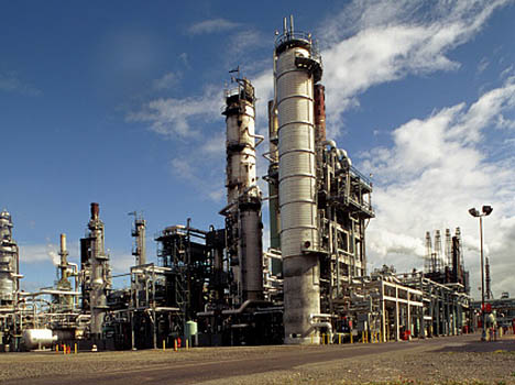
North Dakota Pumps 1 Million Barrels of Oil a Day. That's 1% of the world's supply of crude - pretty amazing. Here's an excerpt from AP and
ABC News: "
North
Dakota has joined the ranks of the few places in the world that produce
more than a million barrels of oil per day, due in large part to the
rich Bakken shale formation in the western part of the state. The April
figures released Tuesday by the state's Department of Mineral Resources
showed the record tally. North Dakota had flirted with the
million-barrel-per-day mark for months, but the harsh winter slowed the
pace. In March, production had hit 977,000 barrels per day. North
Dakota's oil fields now represent more than 12 percent of all U.S. oil
production, and more than 1 percent of global production — a situation
unfathomable just a decade ago, when technology hadn't yet caught up to
the challenge of extracting oil from the shale..."


No comments:
Post a Comment