By Paul Douglas
Call it Atmospheric Karma. After the most severe winter in a generation, the wettest year, to date and soggiest June since 1874 - after dealing with swarms of monsoon-like storms, flooded fields & overflowing lakes, it's time to exhale and enjoy some of the nicest weather of the summer. Falling on a 4th of July weekend? This is our consolation gift.
At the risk of editorializing today will be perfect. "There will be no cooling cost at home Thursday, as nature's air conditioner has kicked in" said my favorite banker at Northern Trust, Jeff Huybrecht.
I'm just happy it's not snowing. Blue sky and low humidity spills over into Friday as temperatures mellow: near 80F tomorrow and 80-85F highs Saturday. Miraculously, dry weather should be the rule today into Saturday; the risk of T-storms increases Sunday, especially up north. All in all better than average for the biggest holiday of summer.
Meteorologists worry about many things, including complacency. There were no hurricanes in 2013; it's been 9 years since a major Category 3 storm hit the U.S. Arthur sideswipes the Outer Banks as a Category 1-2 hurricane on the busiest day of the year, July 4. What can possibly go wrong.
=========
WEDNESDAY NIGHT: Mostly Clear and comfortable. Low: 53.
THURSDAY: Best day in sight. Sunny and perfect. High: 75. Winds: W 5-10.
THURSDAY NIGHT: Mostly clear and a little warmer. Low: 58.
4th of JULY: Sunny start, late-day T-storm risk. Breezy. High: near 80
SATURDAY: Sticky sun, Storms possible. Wake-up: 64. High: 84
SUNDAY: Muggy sun with spotty T-storms. Dew point 72. Wake-up: 70. High: 87
MONDAY: Partly sunny, less humid. Wake-up: 63. High: 83.
TUESDAY: Patchy clouds, Isolated PM T-Storm. Wake-up: 65. High: 84.
WEDNESDAY: Sticky with more storms. Wake-up: 66. High: 82.
=============
This Day in Weather History
July 3rd
1947: Tornadoes hit Marshall and Polk Counties.
=============
Sunrise/Sunset Times for MSP
July 3rd
SUNRISE 532 AM
SUNSET 902 PM
==============
Average High/Low for MSP
July 3rd
Average High: 83F
Average Low: 64F
===============
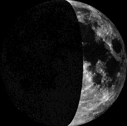
Moon Phase for July 3rd at Midnight
1.2 Days Before First Quarter
===============
Minneapolis Temp Trend
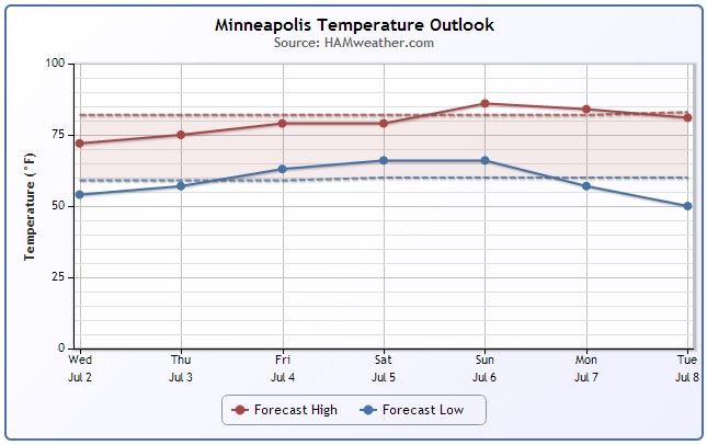
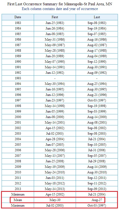
Lacking 90F Temperatures
Can you believe that we have yet to see a 90F temperature at MSP this year? Interestingly, the 30 year average (1983-2013) for our first 90F day is May 30th. According to NOAA's NOWData (Dating back to 1873) the latest 90F day was August 7, 1891.
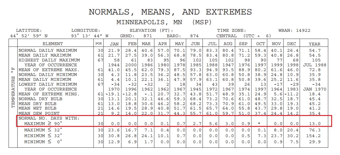
MSP Normals, Means and Extremes
Here are the climate averages (from 1971-2000), which shows the number of 90F days and greater at MSP. According to climate.umn.edu, we typically see 13 90F days each year. 5.6 of those days occur during the month of July! However, we should have seen 3.5 90F days already this year!
4th of July Outlook
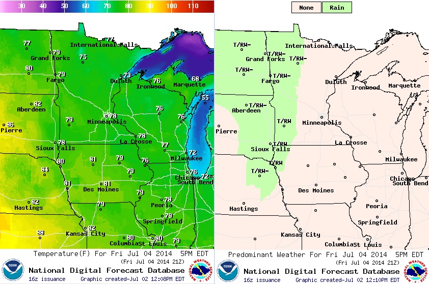
We are NOT expecting any 90s this year for the 4th. In fact, temperatures will be slightly below average (pleasant with low humidity). Daytime highs in the southern part of the state look to warm into the upper 70s, while folks in the northern part of the state will see highs in the low to mid 70s. Keep in mind that most of the day will stay dry, but there is a chance of some late day showers and storms across western MN.
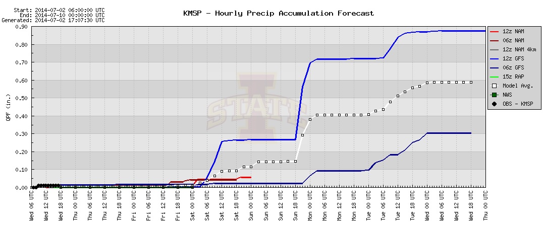
MSP Precipitation Forecast
Here's an interesting take on the MSP precipitation potential over the next several days. The different colored lines represent different model runs. Note that the lines being to 'jump' as we approach the weekend. This would indicate precipitation events; the first jump shows precipitation potential PM Friday/AM Saturday, while the next one shows precipitation potential on Sunday. According to the 12z GFS (AM Wednesday run), the forecast calls for nearly 0.90" of rain through the middle of next week; 0.70" of that falling over the weekend.
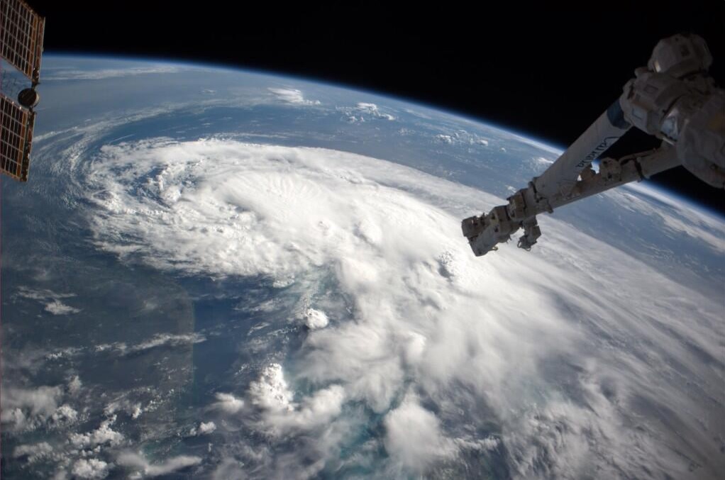
Arthur from the ISS
WOW!! Thanks to @astro_reid aboard the ISS who snapped this is an amazing pic of Arthur earlier Tuesday! You can actually see the southeastern tip of Florida in the bottom left of the picture.
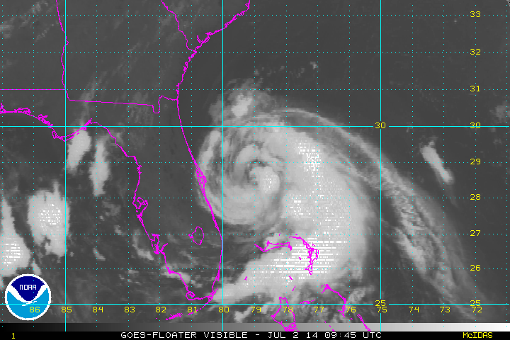
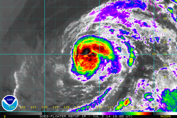
Arthur Churns North
I love visible satellite loops! Take a look at Arthur from earlier Wednesday as he slowly drifted north. Towards the end of the loop, you can actually start to make out an 'eye' feature, which is a pretty typically of hurricane.
Arthur Rainfall
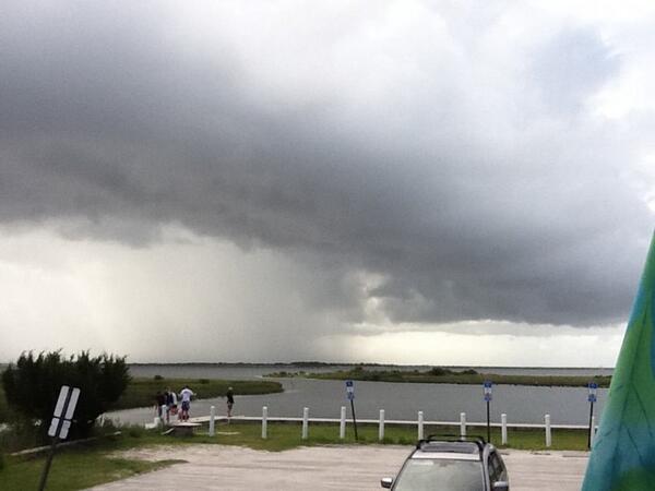
Thanks to @tara_tours from St. Augustine, FL for the picture below. This is one of the rain bands from Arthur as it neared the coast.
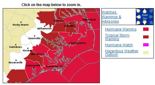
Hurricane Warning
The National Hurricane Center has posted Hurricane Warnings for a number of locations along the coast of North Carolina.
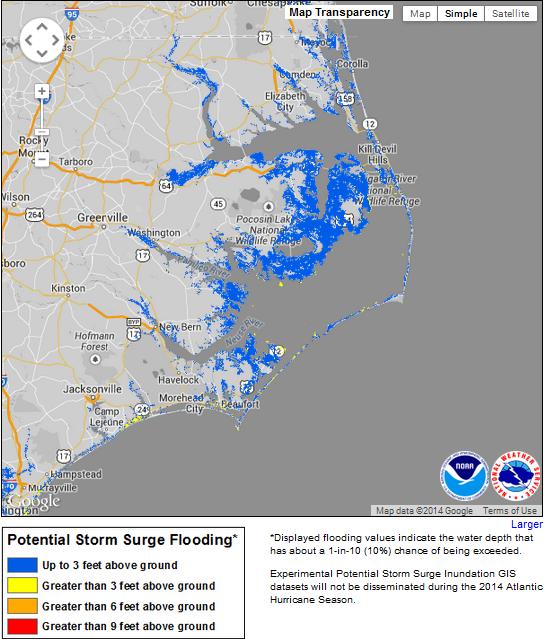
Storm Surge Potential
This is a product from NOAA's NHC that predicts the potential storm surge with the upcoming storm. As of now, storm surge could be up to 3ft. along North Carolina's Outer Banks.
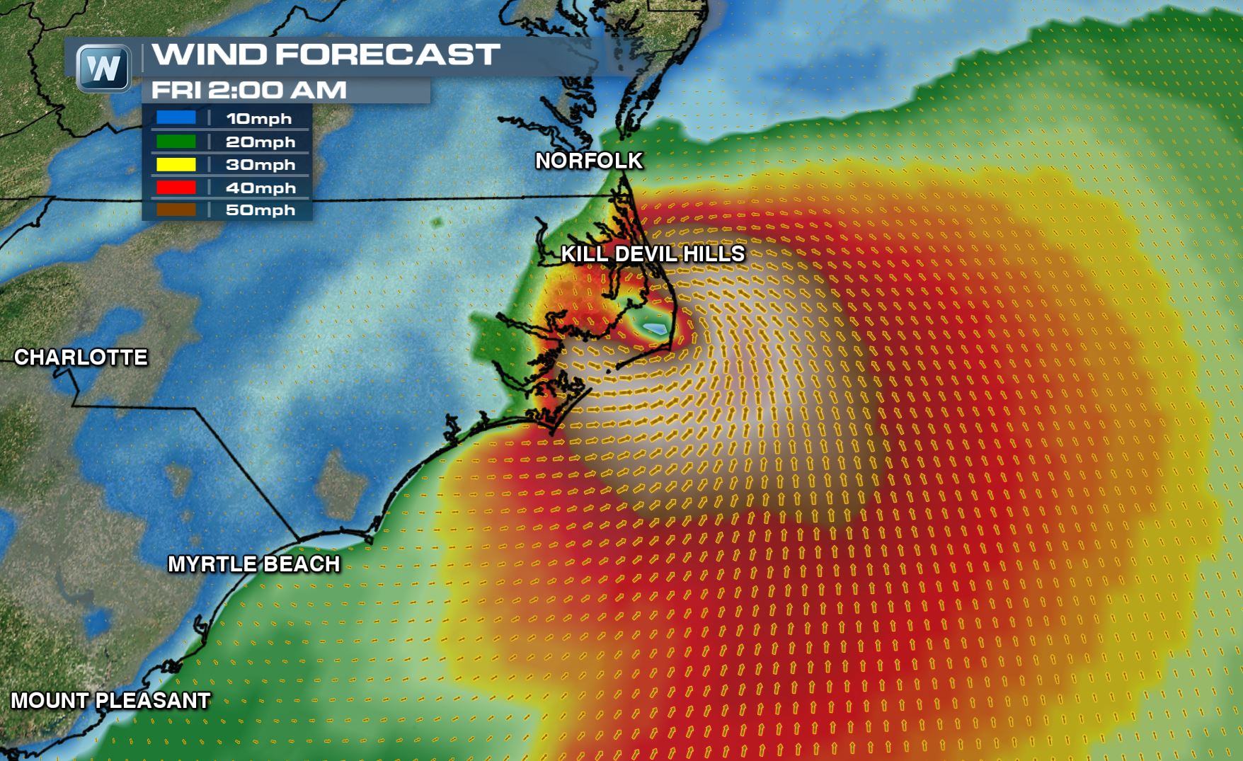
Wind Forecast AM Friday
Unfortunately, the forecast for late Thursday night/early Friday shows the center of circulation over the Outer Banks of North Carolina as potentially and Category 1 hurricane
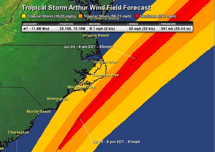
Arthur Wind Forecast
According to NOAA's NHC, the best chance for hurricane force winds (74mph or greater) look to stay just offshore. However, tropical storm force winds look to be possible for some of the inland locations North Carolina.
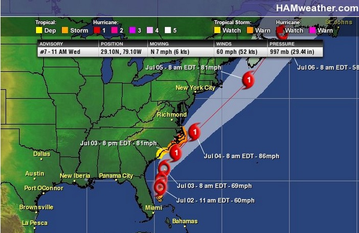
Tracking Arthur
According to NOAA's National Hurricane Center, Arthur is expected to become a hurricane and get VERY close to making landfall with extreme eastern North Carolina by late PM Tuesday/early AM Friday. The good news is that a slow moving cold front across the eastern U.S. will help to push Arthur a little farther east by the time he nears the Northeast coastline...
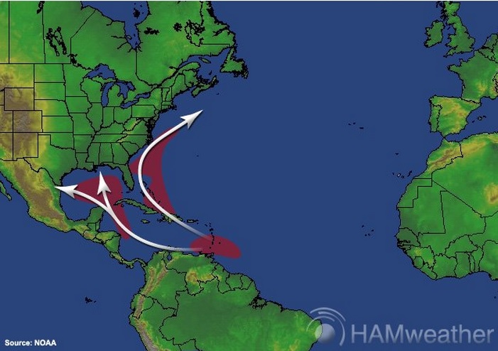
July Climatology
According to NOAA, the origin and path of most July tropical waves are located below. Note that Arthur is falling into the climatological norm.
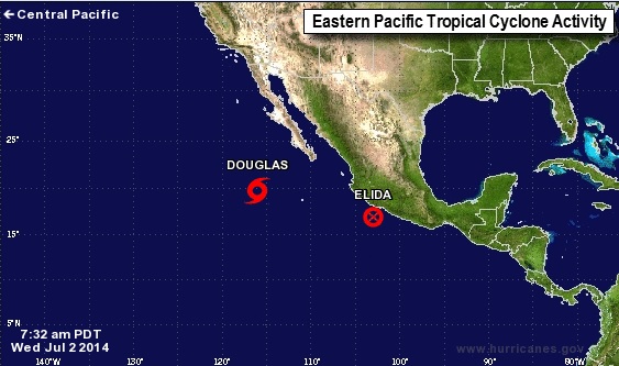
Eastern Pacific Tropical Update
As of midday Wednesday, we still had 1 tropical storms in the East Pacific! The IR satellite of Douglas from midday Wednesday is shown below. Earlier this week, Douglas and Elida were both tropical storms. Keep in mind that these two storms are the 4th and 5th named storms of the Eastern Pacific Hurricane Season, which started on May 15th.
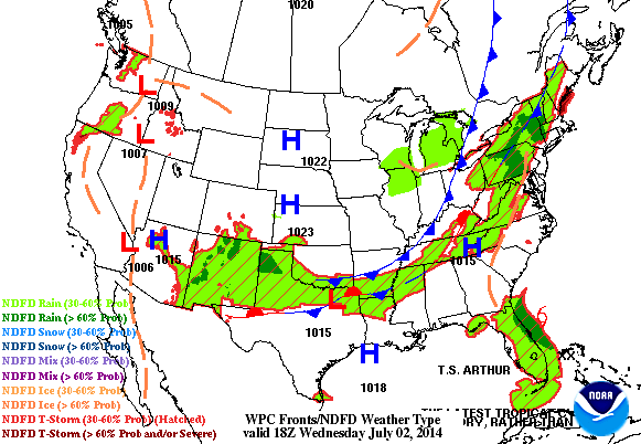
Weather Outlook
Here's the weather outlook through AM Friday as Arthur makes a close encounter with the Outer Banks of North Carolina.
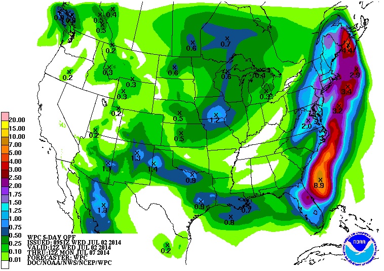
5 Day Rainfall Forecast
According to NOAA's HPC, the 5 day rainfall forecast suggests quite a bit of heavy rain just offshore as Arthur moves north along the coast. However, note the two bands of heavier rain; one is from Arthur which will stay mainly offshore, while the secondary smaller band from Virginia to the Northern New England States is going to be mainly associated with the front as it nearly stalls along the East Coast.
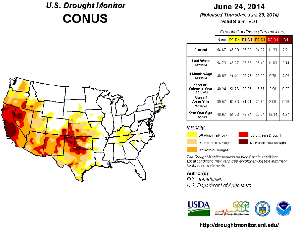
Drought Update
The U.S. Drought Monitor releases the drought monitor every Thursday and this was the update from last week, which shows an ongoing/intense drought across the Western U.S. and in the Southern Plains. As of last week, 35% of the country was considered to be in a moderate drought.
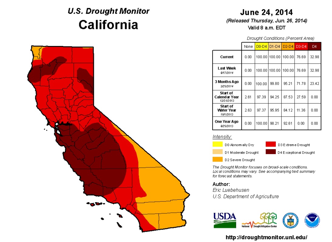
California Drought
Unfortunately, California continues it exceptionally dry outlook. As of last week, nearly 33% of the state was considered to be in an exceptional drought with 100% of the state in a severe drought!
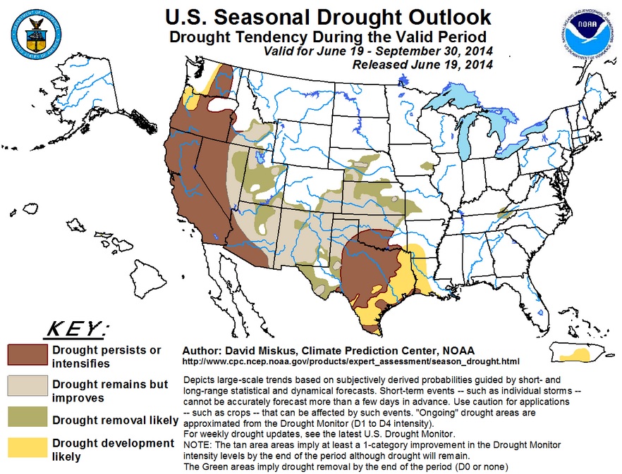
Drought Outlook
According to NOAA, the drought outlook doesn't look good for the Western U.S. as the drought will likely persist if not even intensifying!!
Deer Can't Read (or don't care)
Thanks to Sylvia Musil Blasby - one of my family members from Qualicum Beach, Canada for the picture below! Note the sign in the bottom right... LOL

Thanks for checking in and have a great rest of your week! Don't forget to follow me on Twitter @TNelsonWNTV

No comments:
Post a Comment