78 F. high in the Twin Cities Thursday.
83 F. average high on July 3.
84 F. high on July 3, 2013.
July 3 Minnesota Weather History. Source: MPX National Weather Service:
1999: Windstorm knocked down millions of trees in the BWCA, 19 people were injured.
1977:
An intense squall line, or derecho, brought 115 mph winds to northern
Wisconsin as the storms traveled from Minnesota to Lake Erie. A
tremendous amount of forest was destroyed during the blowdown
1962: Downpour at Jackson, where 7.5 inches of rain fell in two hours.
Better Than Average
At
the rate this year is going I half expected to see a freak 4th of July
blizzard or Tropical Storm Bubba chugging up the Mississippi, maybe a
small sharknado on Lake Minnetonka.
Instead we'll enjoy lukewarm
sun with highs near 80F and a very comfortable dew point in the 50s. Not
bad for the biggest holiday of summer.
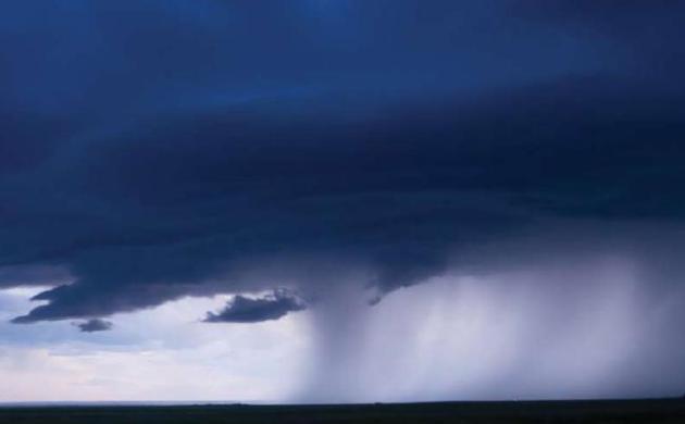
A surge of warmer air may
ignite a few T-storms tonight; timing is a bit tricky, but the risk of
thunder increases by morning with a few scattered storms Saturday, with
creeping humidity levels and enough murky sun for low 80s.
If the
sun stays out most of Sunday the mercury may hit 90F for the first time
this year. According to Greg Spoden at the MN Climate Office only 4
other years since 1974 have been "90-less" as of July 2. Spoden adds
that 3 years - most recently 1993 (another very wet summer) -
experienced NO 90s at all in the Twin Cities. More details below.
We
cool off again next week before heating back up the following weekend.
No sustained heat or humidity is on tap and I suspect the worst of
monsoon season is behind us now.
Meanwhile Category 2 Arthur is chewing up the Outer Banks this morning, about to brush New England.
Our lakes are looking even better.
June: Wettest Month, Statewide, In Recorded Minnesota History. Dr. Mark Seeley has more details at
Minnesota WeatherTalk; here's an excerpt of his latest post: "...
On
a statewide basis the average rainfall for June was 8.09 inches, a
record historical high not only for June, but for any month of the year.
The previous wettest months in Minnesota history on a statewide basis
were June of 1914 and July of 1897 with values of 7.32 inches. Those
individual climate stations setting records for the wettest June
include:
Ada 9.20 inches
International Falls 10.24 inches
Littefork 9.23 inches
Waskish 8.93 inches
Kabetogama 11.58 inches
Benson 10.49 inches
Dawson 8.27 inches
Chaska 13.84 inches
Glencoe 14.61 inches..."
"90-Less" So Far in 2014. Excerpt of an e-mail from Minnesota State Climatologist Greg Spoden:
"
Advancing
into July without a 90-degree max in the Twin Cities is a relatively
common occurrence in the long-term record; roughly one-in-five summers.
However, it is less common in recent decades: occurring only in 1974,
1981, 1993, 2003, and 2014 over the past 40 years. (see: http://climate.umn.edu/text/historical/mspmaxtge90.txt )
There
have been three summers in the Twin Cities record where 90 degrees was
never reached at all: 1902, 1915, and 1993. You may recall the summer of
1993. Like this year (thus far), the summer of 1993 was extraordinarily
wet in the Midwest. It's interesting to note that the previous summer,
1992, reported only three 90-degree days. On average, 1992 was far
colder than 1993. Similar to this year to-date, average temperatures in
1993 were propped up by elevated minimum temperatures due to the
persistent cloudiness..."
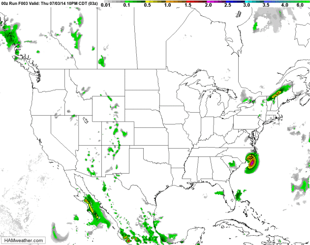
Tracking Arthur - And Another Thundery Warm Front for the Upper Midwest.
You can see the soggy, windblown swirl of moisture associated with
Hurricane Arthur pushing from the Outer Banks into the North Atlantic,
but not before giving Cape Cod a glancing blow later today and tonight.
Meanwhile the next surge of warm, humidifed air sparks more T-storms
from the Dakotas into Minnesota and Wisconsin; the best chance of a few
storms Saturday. 84 hour NAM Future Radar: NOAA and HAMweather.
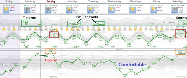
More Big Swings in Dew Point.
The mercury approaches 80 F. today, mid 80s Saturday with a few
T-storms possible, especially northern Minnesota and Wisconsin. By
Sunday afternoon we could see our first 90-degree high of the season in
the Twin Cities. Temperatures gradually cool next week; the dew point
forecast to drop from a sauna-like 75 midday Sunday to near 50 Wednesday
night and Thursday, meaning less than half as much water in the air.
Any fresh air will be fleeting - we heat up again by next weekend.
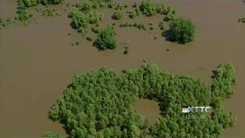
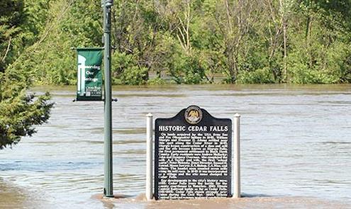
Flooding Causes $32 Million in Damage to Public Infrastructure in Minnesota. Here's a video clip and story excerpt from
KTTC-TV: "
Recent
flooding across Minnesota caused at least $32 million in damage to
public infrastructure. Gov. Mark Dayton and his emergency managers
provided the estimate Tuesday. Flooding damage was seen in nearly half
of Minnesota's counties. Carver County, southwest of the Twin Cities,
has the biggest damage total so far at $9.2 million because of problems
with roads and a wastewater treatment plant. The state has a $3 million
relief fund to help match federal disaster aid. Dayton says it's
possible a special legislative session will be needed if the state
account is tapped out..."
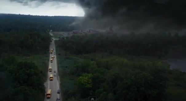
Will "Into The Storm" Become The Next Cult Movie for Weather Fanatic.
No Helen Hunt? I may have to see this anyway - coming to a theater near
you in August. Meteorologically accurate? No way, but the special
effects may be worth the price of admission. Jason Samenow at
Capital Weather Gang has a link to the trailer and excerpt: "...
A
safe prediction: meteorological purists will despise this movie for its
outrageous scenarios and lack of realism, but fans of over the top
disaster drama and extreme special effects will love it. Whether it has
the allure of the Helen Hunt and Bill Paxton classic is up in the air –
right there with the flying cows..."
The Outrage Is Not So Much Over Inequality But All The Dubious Ways The Rich Got Richer. Here's an excerpt of an interesting essay at
Quartz: "...
Wealth
and income inequality are a topic of perennial fascination. But the
heat has been turned up not only by increases in such inequality, but
also by the feeling that the 2008 financial crisis and the Great
Recession suggest that something is fundamentally wrong with our
economic system. Among the many reasons to redesign the monetary
plumbing of our economic system to avoid a repeat of the Great
Recession, one of the most important is to help us gain clarity on the
many long-run issues we face, of which economic inequality is one of the
most difficult to deal with."
Minneapolis: 4th "Least Stressed Out" City in America? That according to
stumbleupon.com; here's an excerpt: "
The
winters may be a bear, but Minneapolis' residents enjoy a quality of
life that's hard to beat. Less than 11% of the city's residents live
below the poverty line, one of the lowest rates of all 55 metro areas
that CNNMoney analyzed. Unemployment is also low, due in part to a
number of large Fortune 500 companies, ranging from Target (TGT) and Best Buy (BBY) to Hormel Foods (HRL) and UnitedHealth Group (UNH)..." (Photo credit: Meet Minneapolis).
4th of JULY: Fading sun, pleasant most of the day with low humidity. Dew point: 55. Winds: S 15. High: 80
FRIDAY NIGHT: More clouds, risk of a T-storm, especially late. Low: 65
SATURDAY: Some sun, scattered T-storms. Dew point: 64. Winds: S 15. High: 84
SUNDAY: Hot sun, T-storms pop later. First 90F reading of 2014? Dew point: 72. Wake-up: 71. High: near 90
MONDAY: A bit cooler, stray T-shower possible. Wake-up: 67. High: 83
TUESDAY: Still unsettled. PM T-showers pop up. Wake-up: 63. High: 80
WEDNESDAY: More sun, big drop in humidity. DP: 56. Wake-up: 61. High: 79
THURSDAY: Mostly sunny and pleasant. Wake-up: 59. High: 81
Climate Stories...
Ignorance is Bliss. Thanks to David Horsey at
The Los Angeles Times for highlighting the idiocy of our carbon-fueled global joy ride.
Climate Report Focuses on Midwest Flooding, Storms and Region's Future. Here's a clip from an interesting read at
EcoWatch: "Here are some facts in the report, issued by five scientists:
- Precipitation
in the Midwest has been increasing since the ’30s, including increases
in overall precipitation and an increase in extreme precipitation
events.
- Midwest flooding presents a major economic risk
in the Midwest—the 1993 Mississippi flood was the costliest flood in
modern times after Hurricane Katrina. In 2008, another flood in Cedar
Rapids incurred over $10 billion in damages.
- These
historic floods were caused by persistent heavy rainfall. Research shows
that the trend towards heavier rainfall events has resulted in an
overall increase in flood risk across the region.
- The
risk of levee failure is a significant hazard, as the Midwest contains
nearly 4,000 miles of levees, many of which are in poor condition.
Photo credit above: "
An Island Press report expounds on the dangers climate change is presenting and will continue to present in states like Iowa." Photo credit: National Climate Assessment.
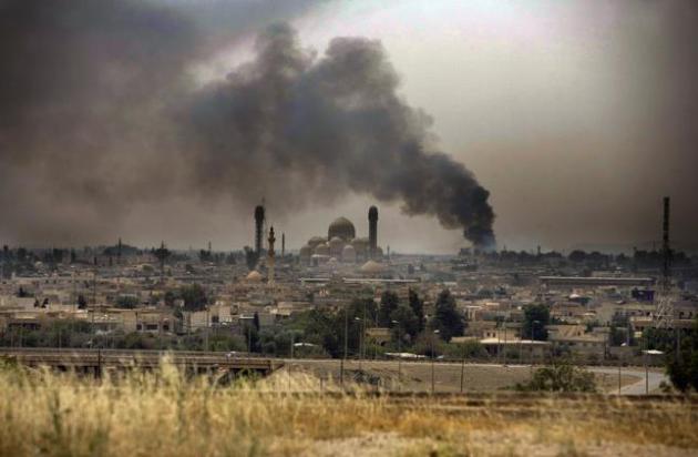
Hot Zone. Is Climate Change Destabilizing Iraq?
This is why we need to pay attention to increasing climate volatility.
Drought can quickly become a force-multiplier, setting revolutions (and
new caliphates in Iraq) into motion. Here's an excerpt from a story at
Slate: "...
Drought is becoming a fixture in the parched landscape, due to a drying trend of the Mediterranean and Middle East region fueled by global warming. The last major drought in this region (2006-2010) finished only a few years ago. When taken in combination with other complex drivers, increasing temperatures and drying of agricultural land is widely seen
as assisting in the destabilization of Syria under the regime of Bashar
al-Assad. Before civil war broke out there, farmers abandoned their
desiccated fields and flooded the cities with protests. A series of U.N.
reports released earlier this year found that global warming is already
destabilizing nation states around the world, and Syria has been no exception..."
File photo from Mosul, Iraq: Moises Saman/The New York Times.
Climate Change Affects U.S.'s Anti-Terrorism Efforts. Here's an excerpt of an Op-Ed from a former Army Officer at
The Des Moines Register: "...
Some
of the least stable states in the world will face changing weather
patterns that reduce arable land and fresh-water supplies, in turn
driving mass-migration, provoking resource conflicts and fostering
global health threats. As a former Army officer, I have seen
firsthand how “climate disruption” puts more of my fellow soldiers at
greater risk. Both the creeping effects of climate change, producing
gradual shifts over time, as well as the increasing frequency and
severity of natural disasters pose unique threats to global security..."
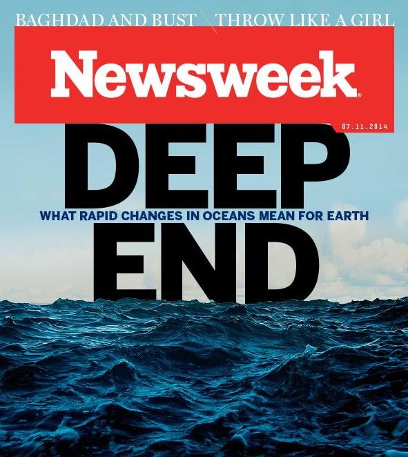
The Disaster We've Wrought On The World's Oceans May Be Irrevocable. Talk about a harrowing read. Here's a clip from
Newsweek's cover story: "...
The
last is the least understood of these phenomena. Along the coasts and
out in the deep, huge “dead zones” have been multiplying. They are the
emptiest places on the planet, where there’s little oxygen and sometimes
no life at all, almost entirely restricted to some unicellular
organisms like bacteria. Vast blooms of algae—organisms that thrive in
more acid (and less alkaline) seawater and are fed by pollution—have
already rendered parts of the Baltic Sea pretty much dead. A third of
the marine life in that sea, which once fed all of Northern Europe, is
gone and may already be beyond hope of recovery. “There’s a profound
game-changing event going on in the life of the sea,” says Callum
Roberts, a professor of marine conservation at the University of York,
England..."


No comments:
Post a Comment