By Paul Douglas
We don't know what we don't know. Models and simulations only go so far. Who knew, in advance, that a cascade of unintended consequences would kill nearly 2,000 Americans during Hurricane Katrina in 2005? Super-storm Sandy in 2012: barely Category 1 strength, but this mash-up of ex-hurricane and Nor'easter was the biggest Atlantic storm on record; a $70 billion 2x4 across the head.
Swiss Re just modeled what would happen if the 2013 EF-5 Moore, Oklahoma tornado hit Chicago. Over 100,000 residents might be impacted with $20 billion in damage.
Downtowns are tiny targets - we've just been very, very lucky. But at some point the law of averages catches up with you.
It's good to be perpetually paranoid - and leverage new technologies to keep up with increasing risk.
The next surge of warm air sparks T-storms tonight. We dry out Friday and highs should still surge into the 80s Saturday before late-day storms sprout.
Sunday won't win any awards; a push of cooler air sparks ragged skies & PM showers. Summer takes a siesta next week as highs dip into the 70s. More hints of September in the air.
Personally I don't miss the 90s or extended heat waves. Think of it as Summer Lite.
========
WEDNESDAY NIGHT: Mostly clear and comfortable. Low: 60 (50s in the outlying suburbs).
THURSDAY: Nice start, clouds increase late. High: 79. Winds: S10.
THURSDAY NIGHT: Chance of thunderstorms. Low: 66
FRIDAY: Partly sunny and warmer. High: 81
SATURDAY: Hazy sun, lake-worthy with late day storms. Dew point: 63 Wake-up: 68. High: 85
SUNDAY: Clouds, cooler with PM showers. Wake-up: 63. High: 82
MONDAY: Partly sunny, less humid. Wake-up: 57. High: 74
TUESDAY: Sunny start, late day T-Storm. Wake-up: 55. High: 77
WEDNESDAY: AM Sun, PM showers pop up. Wake-up: 56. High: 78.
==========
This Day in Weather History
July 24th
1987: Deluge ends in the Twin Cities. Two-day totals include over a foot of rain at Bloomington. Nearly 10 inches in downtown Minneapolis and near 9 inches in St. Paul. At one time the water was as deep as 13.5 feet on I-494 near East Bush Lake Road. I-494 in Bloomington was closed for nearly 5 days.
1891: Heavy frost hits Elkton in Mower County in southeast Minnesota. The heavy frost killed all vegetables and corn. The low in Elkton was 34 and the Twin Cities had a low of 49.
===================
Averages High/Low for MSP
July 24th
Average High: 83°
Average Low: 64°
==================
Moon Phase for July 24th at Midnight
1.7 Days Before New Moon

=========================
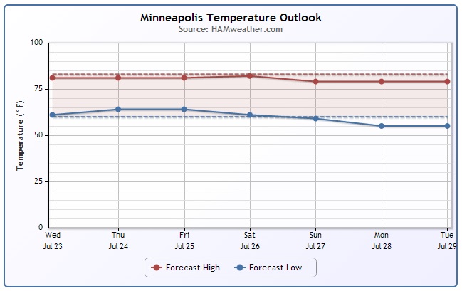
MSP Temp Trend
After a very warm start to the work week, temperatures have leveled off a bit and will continue to cool into next week. In fact, temperatures early next week look to dip into the mid/upper 70s as another blob of cool air drops out of Canada.
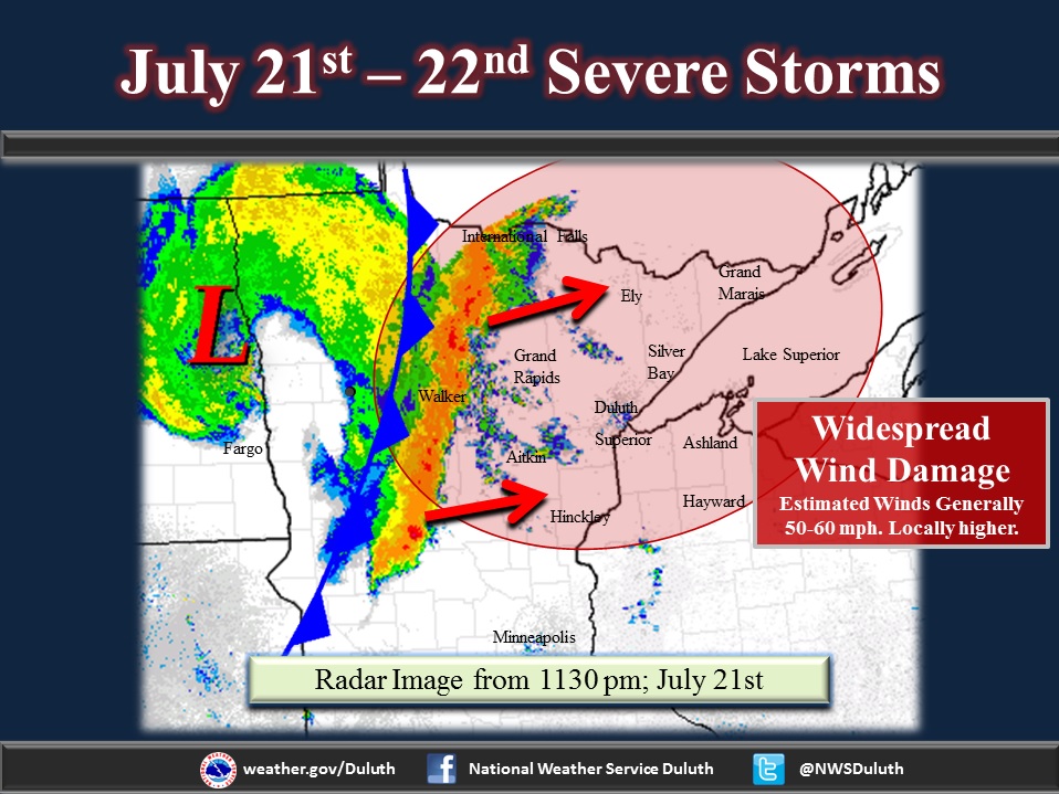
More on the Monday Night Severe Storms
The National Weather Service out of Duluth, MN has a great write-up on the severe storms that rolled through northern MN on Monday Night.
(Photo Courtesy NWS Duluth)
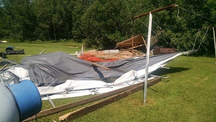
"A strong low pressure system, fueled by abundant moisture and instability, swept across the Upper Midwest and Western Lake Superior region Monday night into Tuesday morning. A line of severe storms developed along the cold front, and brought widespread damaging winds over nearly the entire Northland.
Monday, July 21st, brought south winds and a very hot and muggy air mass to the region. Temperatures across the Northland were in the upper 80s to low 90s. In addition to the heat, dew points were extremely high for this area and resulted in Heat Index values in the upper 90s to low 100s."
See the full story HERE:
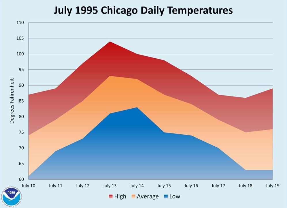
July 1995 Heat Wave
"A record-breaking heat wave affected much of the Midwestern United States in mid-July 1995. The Chicago-area was especially hard hit, and about 750 residents succumbed to the intense heat and high humidity."
"A record-breaking heat wave affected much of the U.S. Midwest in mid-July 1995, and the Chicago area was especially hard hit. From Wednesday, July 12, through Sunday, July 16, 1995, the heat tied or broke a number of temperature records at Chicago’s official reporting station, O’Hare International Airport.
The heat peaked on July 13 when O'Hare Airport had a high of 104°F and a low of 81°F for an average of 93°F, 20 degrees above normal. The heat index—a combination of the temperature and humidity—soared to 119°F at both 1:00 p.m. and 5:00 p.m. CDT. That same day, at Chicago Midway International Airport, on the city’s southwest side, the heat index topped out at 125°F at 2:00 p.m. CDT, with a temperature of 103°F and dew point of 79°F. Even Meigs Field, which sits on a small peninsula jutting into Lake Michigan off the Chicago lakefront, reached 103°F with a heat index of 115°F."
Read more HERE:
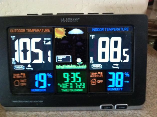
Excessive Heat!
It's summer and triple digit heat is not uncommon in the Desert Southwest, but today there could be record/near record highs again! My mom (a transplant from Minnesota) texted me Wednesday morning and said her A/C broke! UGH!! This is what she sent me at 9:35am Wednesday (local Phoenix time).
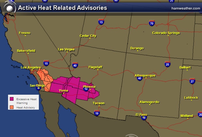
Excessive Heat Continues
Excessive Heat Warnings continue across the Desert Southwest through Thursday. Actual air temperatures could approach 120° in spots. The forecast for Phoenix is 113° and the record is 114°!!
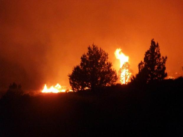
Wildfires Continue in the Western U.S.
With the recent warm and dry weather, several wildfires have cropped up due to isolated thunderstorms. Lightning can be a big contributor to wildfires in the summer months, especially from monsoon thunderstorms. The image below suggests where fires are currently burning.
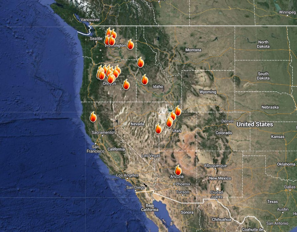
As of Wednesday two of the big fires in the western U.S. were the Carlton Complex in Washington and the Buzzard Complex in Oregon. These fires have consumed several thousand acres; the Carlton Complex is considered the largest fires in the state of Washington's history.
Buzzard Complex: Latest Info HERE
Carlton Complex: Latest Info HERE:
(Photo below of Buzzard Complex courtesy: Inciweb.nwcg.gov)
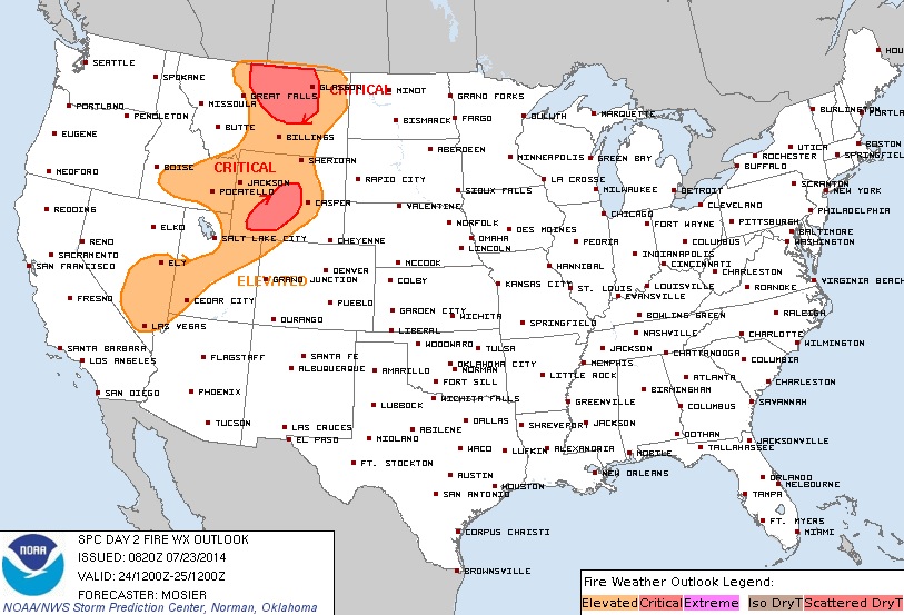
Fire Threat Thursday
A BROAD AREA OF AT LEAST ELEVATED FIRE WEATHER CONDITIONS IS EXPECTED WHERE MODERATE TO STRONG MID/UPPER FLOW AROUND THE UPPER LOW OVERLAPS WITH THE WARM AND DRY CONDITIONS ALONG THE NRN EXTENT OF THE UPPER RIDGE. THE WARMEST AND DRIEST CONDITIONS ARE EXPECTED ACROSS E-CNTRL/SRN NV NEWD INTO SRN WY WHERE MIN RH VALUES FROM THE UPPER SINGLE DIGITS TO UPPER TEENS ARE POSSIBLE. WINDS THROUGHOUT MOST OF THIS AREA WILL LIKELY REMAIN BELOW 20 MPH. SUSTAINED SPEEDS FROM 20 TO 25 MPH ARE PROBABLE ACROSS CNTRL WY WITH A RESULTANT CRITICAL FIRE WEATHER THREAT. ADDITIONALLY...SOME LOCALLY CRITICAL FIRE WEATHER CONDITIONS ARE POSSIBLE OVER THE SNAKE RIVER PLAINS. FARTHER N /CNTRL AND ERN MT/...FORECAST IS COMPLICATED BY DIFFERENCE IN SUGGESTED FRONTAL TIMING AMONGST THE GUIDANCE. NAM FORECAST IS FASTER AND TAKES THE COLD FRONT INTO ERN MT BY 21Z...LIMITING POTENTIAL DOWNSLOPE EFFECTS IN THE LEE OF THE ABSAROKA RANGE. GFS IS SLOWER WITH A FORECAST DEWPOINT 25 DEG F LOWER THAN THE NAM AT BIL. AS A RESULT...CONFIDENCE IS TOO LOW FOR A CRITICAL DELINEATE WITH THIS FORECAST. IN CONTRAST... CONFIDENCE IN CRITICAL FIRE WEATHER CONDITIONS IS HIGH ACROSS N-CNTRL MT WITH A THREAT AREA DELINEATED ACCORDINGLY.
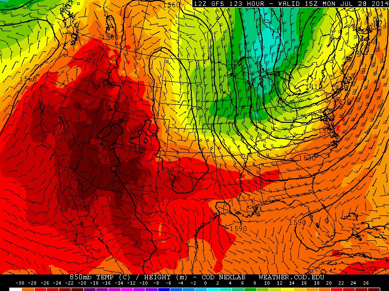
Cool Temps on the Way for the Eastern U.S.
Looking at the temperature outlook by late weekend/early next week, it appears that we're in for another round of non-July weather as a blob of cool air heads out of Canada post cool front.
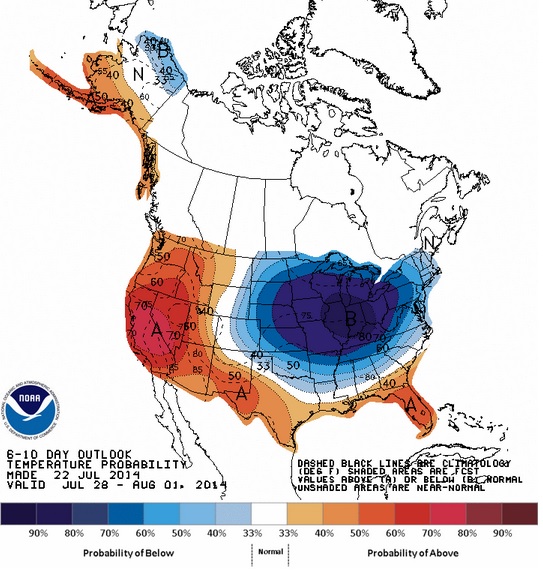
Temperature Outlook
According to NOAA's Climate Prediction Center, the 6 to 10 day temperature outlook from July 28th - August 1st shows a fairly significant chance of below normal temperatures during that time frame.
8 Years Ago...
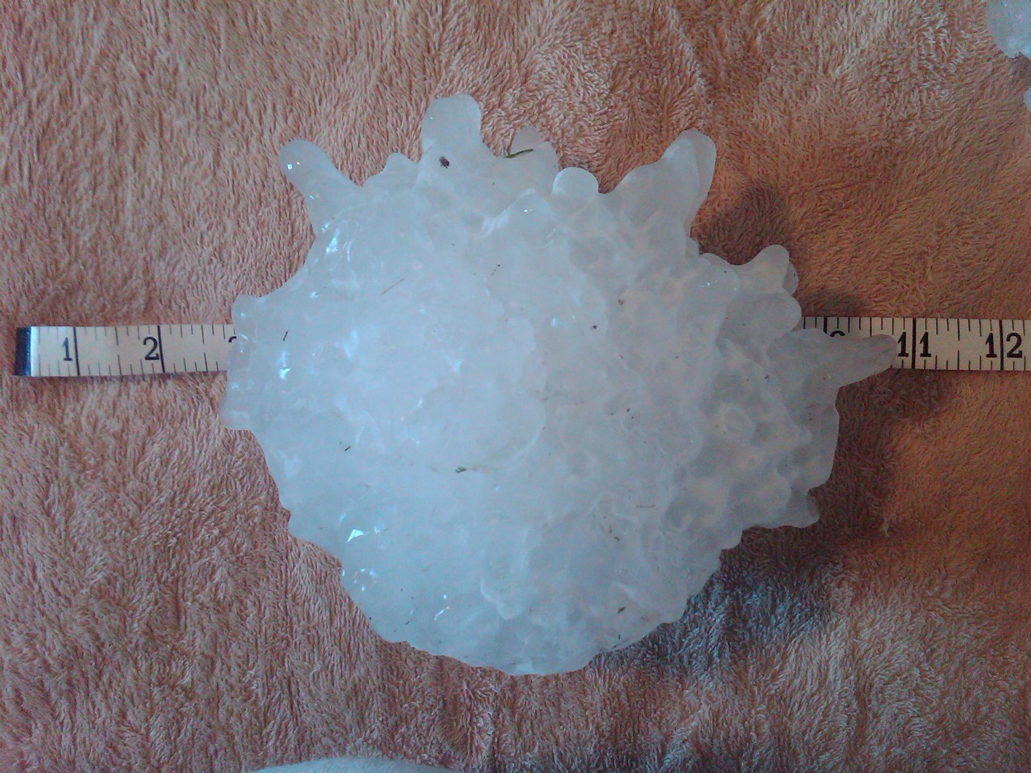
It was 8 years ago (July 23rd) that the largest hailstone on record fell in Vivian, SD with a diameter of 8" and weighing nearly 2 lbs.!!
"A record setting hailstone was ultimately discovered in Vivian, measuring 8.0 inches in diameter, 18.625 inches in circumference, and weighing in at an amazing 1.9375 pounds!! This hailstone broke the previous United States hail size record for diameter (7.0 inches - 22 June 2003 in Aurora, NE) and weight (1.67 pounds - 3 September 1970 in Coffeyvile, KS). The Aurora, Nebraska hailstone will retain the record for circumference (18.75 inches)."
See the full story from the NWS HERE:
(photo courtesy: NWS Aberdeen, SD)
Weather Outlook
A storm system in the Pacific Northwest will send an impulse of energy east through the High Plains/Midwest over the next couple of days. A few strong/severe storms may be possible, but heavy rain will be an issue as well.
This impulse of energy will be responsible for some isolated strong storms across the High Plains/Midwest over the next couple of days...
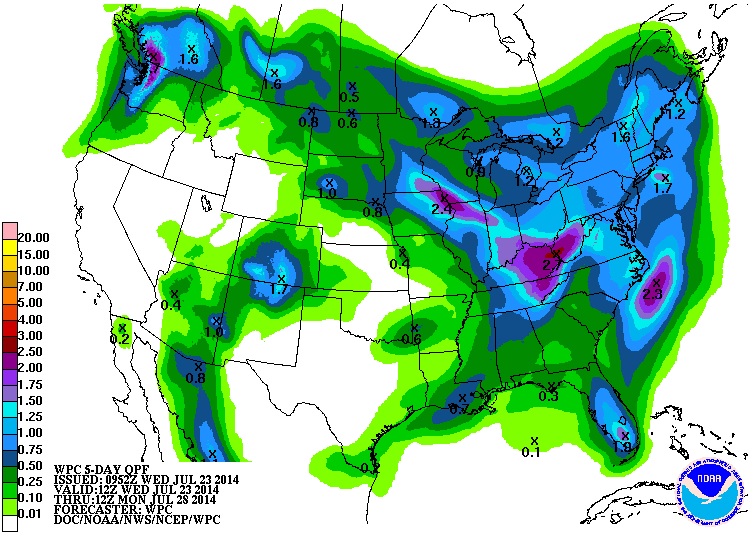
Precipitation Outlook
According to NOAA's HPC, the 5 day rainfall forecast suggests a fairly decent blob of moisture across parts of the Midwest as our next system approaches through the end of the week. There is a chance that if the rain comes down hard enough, isolated flash flooding couldn't be ruled out in southeastern parts of MN through northern Illinois.
Tropical Update
Tropical Depression #2 in the Atlantic Basin was no longer by midday Wednesday. This particular system ran into dry air and stronger winds aloft, which basically killed it. Note the bright glare moving from right to left on the bottom part of the loop below. That's called "Sun Glint" !! The sun is reflecting off the Atlantic Ocean and the satellite is seeing the glare... pretty cool, huh?!
NHL Says Climate Change Threatens Future of Hockey
Now this would be a sad day... check out this story from PressProgress.ca HERE
"The National Hockey League now says it is worried that climate change could have a devastating impact on the future of hockey in coming decades.
"Our sport can trace its roots to frozen freshwater ponds, to cold climates," NHL Commissioner Gary Bettman says in a letter accompanying the league's Sustainability Report, released Monday night. "Major environmental challenges, such as climate change and freshwater scarcity, affect opportunities for hockey players of all ages to learn and play the game outdoors.""

Thanks for checking in and have a great rest of your week. Don't forget to follow me on Twitter @TNelsonWNTV

No comments:
Post a Comment