83 F. high in the Twin Cities Wednesday.
81 F. average high on August 13.
76 F. high on August 13, 2013.
August 13, 1978: Boundary Waters area hit by a tornado, some of the damage could still be seen 10 years later.
The Monsoons of August
Most
of us lead impossibly hectic, over-stimulated lives, on call 24/7. The
idea of a more volatile, extreme climate often elicits a shrug. "Paul, I
barely have time to brush my teeth. I don't want to ponder big issues I
have no control over."
And that's the thing about climate change.
It only hits home...when it hits home. For me there was no overnight
epiphany. It was a series of puzzle pieces locking into place over 20
years.
This week record flooding hit Detroit, Baltimore and Long
Island. Islip picked up over 13 inches of rain as a line of storms
stalled, "training echoes" dumping 4-5 months of rain in a few hours.
More symptoms of a warmer, wetter climate.
New research
suggests changes in the Arctic are having a domino effect on jet stream
winds, as more elongated and amplified "Rossby Waves" create conditions
more favorable for extreme heat and record rains.
Meanwhile
Minnesota's weather has been stunning; postcard-perfect. Expect a run of
80s into next week as weather we should have enjoyed in July finally
shows up. A few T-storms bubble up Friday night into next week.
With any luck they won't stall and flood. We already got a big, sloppy taste of the new normal back in June.
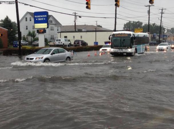
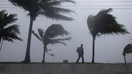
* Twitter image above courtesy of
WPRI-TV in Providence, Rhode Island.
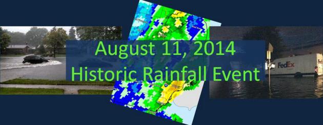
Historic Detroit Floods of August 11, 2014. Here's an excerpt of a good recap of what just happened in the Detroit area, courtesy of the
National Weather Service Central Office: "
A
historic rainfall event unfolded over Southeast Michigan on Monday,
August 11, leading to significant flooding and major road closures.
This event was caused by a low pressure system moving over the area and
with the atmosphere being very moist created the heavy, continuous rains
that were seen. The hardest hit areas included Metro Detroit and
surrounding communities, along with Flint and the Saginaw Valley areas.
Wayne, Southern Oakland and Macomb counties saw the worst of the
flooding as 4 to 6 inches of rain fell over a 4 hour period..."
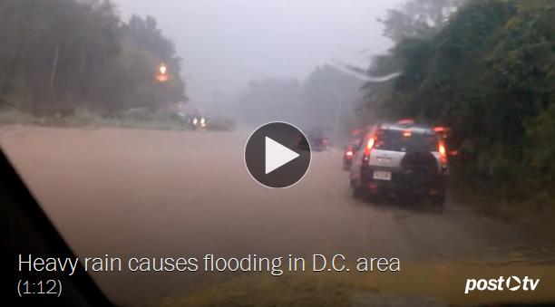
Water, Water Everywhere: The Anatomy of Tuesday's Flash Flooding Event. The Washington Post's
Capital Weather Gang has some eye-popping details of Tuesday's instant-monsoon; here's an excerpt: "
On
Tuesday morning around 10 a.m., an area of very intense rainfall set up
over the Washington-Baltimore region, and then parked there for the
rest of the afternoon. The precise location of the heaviest rain
accumulation was not anticipated in advance, as is often the case in
summertime, flash flood-producing storms – an unfortunate shortcoming of
even our best forecasting efforts. By the end of the day, over 10
inches of rain fell south of Baltimore in northern Anne Arundel County,
which was the hardest hit area. In D.C., over two inches of rain fell.
Dozens of water rescues were made throughout Tuesday’s event, and numerous incredible flash flood images were documented on social media..."
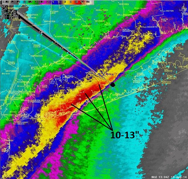
New York State Rainfall Record?
Over 13" of rain doused Islip, on Long Island. According to Andrew
Rosenthal at Earth Networks the 24-hour rainfall record in New York
State is 11.6" in Tannersville NY, so the 13.51" at Islip marks a new
24-hour rainfall record for The Empire State. Here's a summary at
The New York Times.
Map credit: New York City
National Weather Service.
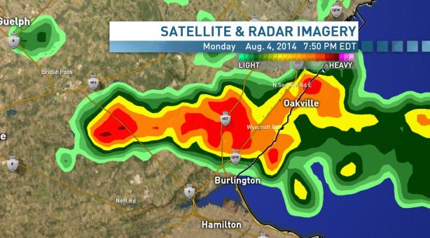
Burlington Flood: Cities Face "New Breed" of Storms, Climatologist Says.
CBC
in Hamilton, Canada has the story - this is part of the same flooding
system that swamped much of Detroit in recent days. Here's a clip: "...
Canadians
are facing a "new breed" of storms, and governments should change the
way they plan for the kind of wild weather that caused a flash flood
in Burlington, Ont., on Monday, says Dave Phillips, Environment Canada's
senior climatologist. "These [once in] 50-year floods are occurring
every 10 years, because our climate has changed," he said. Phillips
added that planning for weather based on the past 100 years "masks"
recent events that have dramatically changed how much rain falls. He
said in the aftermath of the Toronto floods of August 2013, a look into
the last 25 years of rainfall showed that there were three 100-year
storms, and six 50-year storms..."
Graphic credit above: "
The
heavy rain over Burlington, Ont., on Aug. 4 was an isolated event, but
climate change seems to be accompanied by more extreme storms that
overwhelm infrastructure and cause flooding."
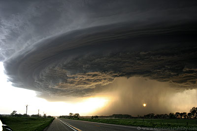
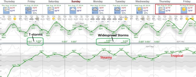
Back into A Warm, Thundery Soup.
The last few days have been flawless - about as good as it gets. Ever.
Dew points rise to near 70F by the weekend, and remain in the upper 60s
to low 70s into next week. A few storms may flare up Friday (especially
Friday night), another round of rumbling Monday and Tuesday. Long-range
guidance hints at highs near 90F by the end of next week.
Holding Pattern.
The same storm that triggered historic flooding from Long Island into
much of New England stalls over Quebec, keeping showery rains into
northern New England into Saturday. A few T-storms push across the
Dakotas into Minnesota by Friday, monsoon-driven instability T-storms
providing slight, temporary relief from the heat across the Rockies. No
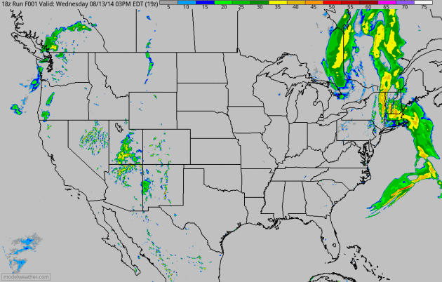
rain for California. Same old story. 4 KM NAM guidance: NOAA and
HAMweather.
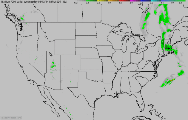 Accumulated Rainfall
.
60-hour data (4 KM NAM) shows heavy rains tapering over New England,
heavy T-storms capable of flash flooding over the Rockies, another band
of moderate rain from New Orleans to Savannah between now and 2 AM
Saturday. Animation: NOAA and HAMweather.
Global Crop Update.
China's breadbasket may be facing one of its worst droughts since 1951,
which may impact prices in the weeks to come. USDA has the latest
report
here.
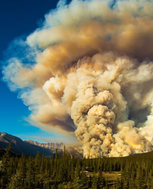
A Real-Life Blazing Inferno. Photo courtesy of Amanda Nand and
National Geographic: "
Smoke rises above the mountain range near a helicopter base in Banff National Park."
It's Mid-August. Where Are All The Atlantic Hurricanes? Bloomberg has a reality check - here's an excerpt: "...
So,
what’s with the Atlantic? After just about two and half months,
hurricanes Arthur and Bertha are all the Atlantic has managed to come up
with. While it may seem as though the Atlantic is failing to keep up
with the larger ocean, the basin is pretty much on pace in terms of the
long-term average. The Atlantic can usually be expected to produce its
third storm of the season, which began June 1, by today, according to
the U.S. National Hurricane Center in Miami. Of course, if the recent past is considered, the Atlantic looks almost anemic..."
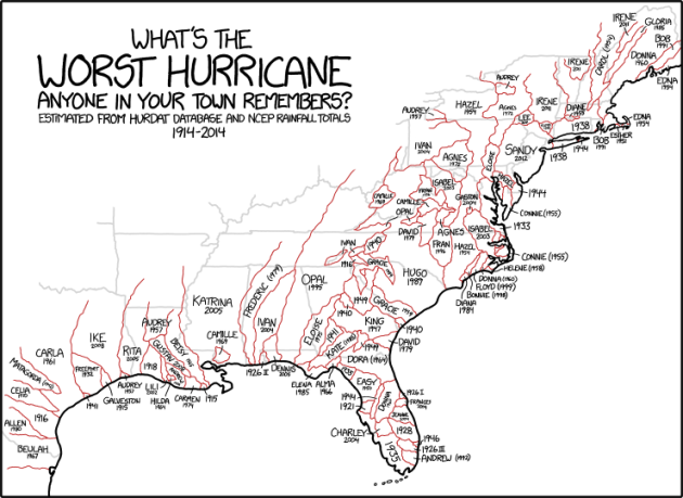
What's The Worst Hurricane You Remember?
If it wasn't for Tropical Storm Agnes which flooded out my boyhood home
in Lancaster, Pennsylvania back in 1972 I might have a real job by now.
Jason Samenow asks a good question at
Capital Weather Gang: "
Comic
artist Randall Munroe, creator of the wildly popular (and awesome)
“webcomic of romance, sarcasm, math, and language” known as xkcd, posts this offering today..."
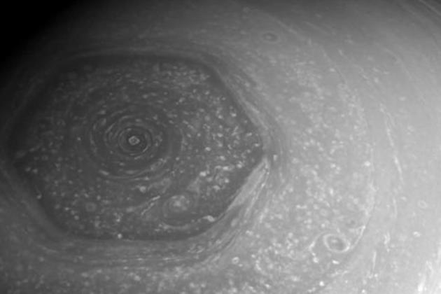
There's a Hexagonal Hurricane on Saturn. I suspect the laws of physics are pretty much the same on Saturn - no Earthly idea how this can happen, but this story at
Mental Floss got my attention. Here's a clip: "...
On Saturn, a giant hexagonal storm
rages around the north pole. The storm is so big, you could fit four
Earths in it. We photographed the storm in the very early 1980s, when
the Voyager probes flew by. But for years, the storm has been hard to
view because it has been tilted away from the sun, making infrared
photos the only option. Now that springtime has returned to Saturn's
north pole, we're looking again at this bizarre, endless, and oddly-shaped storm..."
Image credit above: YouTube / The New York Times.
The Growing Threat From An EMP Attack.
To paraphrase George Carlin, don't sweat the thundershowers. nuclear
explosion high above America could knock out communications and
electricity to most of the USA, knocking us back to the mid-1800s. And
most or all of the risk posed to America's power grid could be removed
for around $2 billion, roughly what we give to Pakistan every year,
according to this Op-Ed at
The Wall Street Journal; here's a clip: "...
In
December 2012, the North Koreans successfully orbited a statellite, the
KSM-3, compatible with the size and weight of a small nuclear warhead.
The trajectory of the KSM-3 had the characteristics for delivery of a
surprise nuclear EMP attack against the U.S. What would a successful EMP
attack look like? The EMP Commission, in 2008, estimated that within 12
months of a nationwide blackout, up to 90% of the U.S. population could
possibly perish from starvation, disease and societal breakdown..."
Dr. Drew on Media Coverage of Depression: "Stop Thinking About It As A Sensitive Topic."
Amen. We don't stigmatize people who have diabetes. "You don't need
insulin - just get over it!" Depression is no different - it's a
chemical imbalance in the brain, and the message is clear: treatment
options are available that can help. Here's a clip from a story at
TVNewser: "...
And
one cable news host with expertise on the subject has a message for TV
news talent and journalists. “Stop thinking about it as a sensitive
topic,” Dr. Drew Pinsky told TVNewser in an interview this afternoon.
“Think of it like a topic like any other medical condition, like a
cardiac problem, or a lung problem; it just happens to affect the
brain.” “It’s disturbing to me we talk about things like inner demons,
which, for God’s sake, is sort of a language that comes out of the
Middle Ages. They’re not inner demons; it’s a brain state precipitated
by complicated interactions with the environment and it’s a biology that
has a medical treatment...”
Intelligent Blinker Bracelet Automatically Gives Cyclists Flashing Turn Signals.
I'm spending more time on my bike (I run when chased, cycling seems
more fun - especially going downhill). Here's a great little innovation
featured at
Gizmag: "
As
any serious bicycle commuter will tell you, it's important to let
drivers know what you're doing by signaling your intention to turn.
Needless to say, the more visible your hand signals are, the safer you
should be. That's why a group of doctoral students at Switzerland's EPFL
research institute created the Intelligent Blinker. It's a wrist
bracelet that automatically starts flashing when the wearer raises their
arm to signal..."
I Think I'll Swim In The Lake, Thank You.
Huffington Post
has a story that serves as a blunt reminder why you want to shower
before and after you enter a public swimming pool. Remind me to wear my
wet suit. Here's an excerpt: "...
That sign in the locker room is not
a mere suggestion. While very few of us would skip a post-swim shower
(got to get that icky chlorine off!), we should probably follow the
pre-swim rules with a little more vigor. "If we don't shower before we
get in the water, we're going to carry in whatever's sitting on our
skin," says Michele Hlavsa, RN, MPH, an epidemiologist and the chief of Healthy Swimming and Waterborne Disease Prevention at the CDC. That includes natural oils, sweat, makeup and other personal care products, urine and, yep, fecal matter..."
Does This Come With a Surgeon?
I'm looking forward to hanging out at the Minnesota State Fair, and
bulking up a little for winter. What you see above is but a small sample
of some of the
new, heart-healthy foods available this year. Come early, and bring your pacemaker!
TODAY: Lukewarm sun, still nice. Dew point: 57 Winds: SE 8. High: 82
THURSDAY NIGHT: Partly cloudy, still dry. Low: 65
FRIDAY: Humid with more clouds. T-storms likely. Dew point: 64. High: 83
SATURDAY: Sticky sun, few T-storms. Wake-up: 68. High: 84
SUNDAY: July-like. Mix of sun and storms. Wake-up: 69. High: 83
MONDAY: Muggy, more numerous T-storms. Wake-up: 68. High: 82
TUESDAY: Unsettled, lingering storms. Dew point: 67. Wake-up: 67. High: 84
WEDNESDAY: Some sun, still steamy. DP: 69. Wake-up: 66. High: 87
Climate Stories....
Global Warming is Moistening The Atmosphere.
The Guardian had a story that confirmed my suspicions; here's a clip: "...
The
authors show that the long-term increase in water vapor in the upper
troposphere cannot have resulted from natural causes – it is clearly
human caused. This conclusion is stated in the abstract,
Our
analysis demonstrates that the upper-tropospheric moistening observed
over the period 1979–2005 cannot be explained by natural causes and
results principally from an anthropogenic warming of the climate. By
attributing the observed increase directly to human activities, this
study verifies the presence of the largest known feedback mechanism for
amplifying anthropogenic climate change.
Heavy Downpours Increasing: Scientists. No
kidding. Wet areas are getting wetter, dry areas drier. Where have you
heard that before? Oh right, the climate models predicted this 30 years
ago. From climate theory to reality. Here's an excerpt from
ABC News: "...
Record-breaking
rain storms like the ones this week, climate scientists say, are
something people should get used to as they continue to warm the planet.
It doesn’t take much warming to have a significant impact on rain
storms. For every one degree of temperature rise, the atmosphere can
hold 7 percent more evaporated moisture, say scientists.
(Temperatures in the U.S. have risen by as much as 1.9 degrees
Fahrenheit since 1895.) “When it rains, it pours,” says Kevin Trenberth,
a scientist at the National Center for Atmospheric Research in Boulder,
Colorado. “Global warming encourages what would have been a normal
rainstorm to become a real downpour and increases the risk of flooding...”
Siberian Crater Mystery Solved? Here's a video clip and story excerpt at
EcoWatch: "...
The
show revealed that Russian researchers “have linked the Siberian
craters to the abnormally hot summers … of 2012 and 2013 which were
warmer than usual by an average of 5 degrees celsius. As temperatures
rose, the researchers suggest, permafrost thawed and collapsed,
releasing methane that had been trapped in the icy ground.” Mann said
that, while the percentage of methane found inside these craters has
been as high as 9 percent compared to an atmospheric level of fraction
of a fraction of a percent and methane is more closely linked to warming
than carbon emissions, it’s premature to throw up our hands and give
up. And he explains why continuing to focus on reducing carbon emissions
is essential..."
The Frustrating Climate Change Memes That Just Won't Die. They just get recycled, regurgitated. Here's a clip from
New Republic: "...
Climate
deniers twisted NASA atmospheric scientist Norman Loeb’s words last
week when he tried to explain that the recent slowdown in temperature
rise, something scientists have observed for a while, is very much
consistent with global warming. The reason: Oceans are heating up, while
surface temperatures are still at their hottest. The deniers never tell
that part.It’s not the only climate denier myth that lives on despite
reality. Deniers love to say that scientists predicted “global cooling”
before they found global warming. Again, that was never true..."


No comments:
Post a Comment