80 F. high in the Twin Cities Thursday.
81 F. average high on August 14.
78 F. high on August 14, 2013.
August 14, 1936: St. Paul swelters with a high of 108.
A Slippery Outlook
Dan
Spencer summed it up best. "On cable TV they have a weather channel —
24 hours of weather. We had something like that where I grew up. We
called it a window." That window comes in handy.
One of the
frequent complaints I hear out on the street: "Paul, with all due
respect, you're a bonehead. How can I read the paper and watch TV and
get 5 different forecasts? Aren't you guys all using the same models?"
Good
point. The best forecasts still use a man-machine mix. People and
experience guide which models are have the best chance of approximating
reality. And much like a financial planner sifting through Wall Street
data, it all comes down to interpretation. In some countries
meteorologists HAVE to use the official government forecast. Here in the
USA we are free to disagree. We have the freedom to be wrong.
Storms
prowl the state today; the best chance of getting wet south/west of
MSP. The weekend looks sunnier, drier and warmer; highs surging into the
80s.
The maps look more like mid-July - a sluggish jet stream
pumping tropical air north, sparking more beefy thunderstorms next week.
We may even hit 90F once or twice.
Summer started slow but we're making up for lost time.
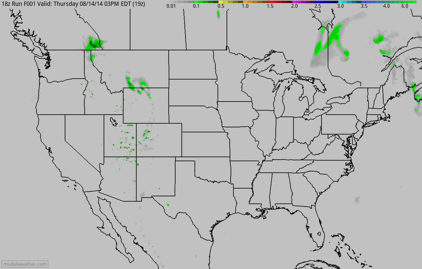 Increasingly Thundery Midwest: Flash Flood Potential Omaha & Sioux City
.
A surge of tropical air sets off T-storms over southwestern Minnesota
today; a better chance of storms reaching the MSP metro late Saturday as
highs surge well into the 80s to near 90F. Cooler air follows on
Sunday, before temperatures heat up again next week. A stalled cut-off
low keeps cool, showery weather over New England; orographic storms
flaring up across the Rockies; more storms capable of flash flooding
from near Daytona Beach to Miami. 4 KM NAM 60-hour rainfall
accumulation: NOAA and HAMweather.
A Sticky Rut.
Temperatures drop off a bit Sunday and Monday, but latest NAM guidance
is hinting at upper 80s Saturday, again the end of next week. With
frontal boundaries lurking nearby we'll have a low-grade thunder risk
into next week; the best chance of storms late Saturday, again Monday.
Dew points will be noticeable, brushing 70F much of next week. Don't
write summer heat & humidity off just yet.
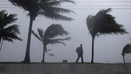
45 Photo of Hurricane Camille 45 Years Later.
Camille may still have the distinction of being the most severe
hurricane to hit the U.S. coast in recent history; an extreme Category 5
with sustained winds over 200 mph.
NOLA.com in New Orleans takes a look back at this remarkable and terrifying display of nature at its worst; here's a clip: "...
That
was hardly the case on the Gulf Coast, where the Category 5 storm
struck early the next morning between Bay St. Louis and Pass Christian
after its rains had inflicted heavy flooding upon Plaquemines Parish.
Some reports put Camille's top wind speed at 200 mph, but the exact
velocity will never be known because the storm destroyed the measuring
instruments. Camille laid waste to the coast. New Orleanians empathized,
not only because they had endured massive hurricanes, too - most
notably Betsy in 1965 - but also because the Gulf Coast had always been a
place to smile about..."
Photo credit above: "
Pass
Christian, Miss., Civil Defense Director Parnell McKay looks over the
town's main business district after Hurricane Camille vlew through." (Photo by Jack Thornell, Associated Press)
It's Mid-August. Where Are All The Atlantic Hurricanes? Bloomberg has a reality check - here's an excerpt: "...
So,
what’s with the Atlantic? After just about two and half months,
hurricanes Arthur and Bertha are all the Atlantic has managed to come up
with. While it may seem as though the Atlantic is failing to keep up
with the larger ocean, the basin is pretty much on pace in terms of the
long-term average. The Atlantic can usually be expected to produce its
third storm of the season, which began June 1, by today, according to
the U.S. National Hurricane Center in Miami. Of course, if the recent past is considered, the Atlantic looks almost anemic..."
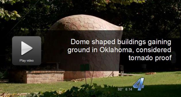
A Tornado-Proof Home?
That may be too much to hope for if a stray EF-5 passes overhead, but
tornado-resistant? Possibly. My next home will be shaped like a flying
saucer, capable of sinking underground at the flip of switch, with a
periscope so I can check to see if it's safe to go outside. That sounds
cozy. Here's an excerpt from a video and story at
KFOR.com in Oklahoma City: "
Round
shaped buildings have gained ground in Oklahoma. Residents might
recognize the dome shaped buildings that have been around for a while
like the Gold Dome in Oklahoma City and the Red Barn in Arcadia. Now,
monolithic domes are acting as safe houses. Designers and builders also
claim they are tornado proof..."
The Growing Threat From An EMP Attack.
To paraphrase George Carlin, don't sweat the thundershowers. nuclear
explosion high above America could knock out communications and
electricity to most of the USA, knocking us back to the mid-1800s. And
most or all of the risk posed to America's power grid could be removed
for around $2 billion, roughly what we give to Pakistan every year,
according to this Op-Ed at
The Wall Street Journal; here's a clip: "...
In
December 2012, the North Koreans successfully orbited a statellite, the
KSM-3, compatible with the size and weight of a small nuclear warhead.
The trajectory of the KSM-3 had the characteristics for delivery of a
surprise nuclear EMP attack against the U.S. What would a successful EMP
attack look like? The EMP Commission, in 2008, estimated that within 12
months of a nationwide blackout, up to 90% of the U.S. population could
possibly perish from starvation, disease and societal breakdown..."
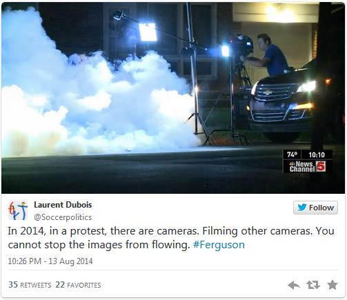
Crowd-Powered Journalism Becomes Crucial When Traditional Media Becomes Unwilling or Unable. Twitter once again transformed the news cycle with events unfolding in Ferguson, Missouri. Here's an excerpt from
Gigaom: "
Amid
all the trolling and celebrity hoo-ha that takes place on Twitter and
other social-media platforms, occasionally there are events that remind
us just how transformative a real-time, crowdsourced information
platform can be, and the violent response by local police to civil protests
in Ferguson, Missouri on Wednesday is a great example. Just as the
world was able to see the impact of riots in Tahrir Square in Egypt
during the Arab Spring, or military action against civilians
in Ukraine, so Twitter provided a gripping window into the events in
Ferguson as they were occurring, like a citizen-powered version of CNN..."
All The Myths That Are Fit To Print: Why Your News Feels Familiar. News repeats itself in regular, almost predictable cycles? That's news to me, but I found this story at
Reuters interesting; here's an excerpt: "...
Sometimes
the news actually repeats itself, as in the case of Clinton. Such
man-made cycles as elections, the Olympics, and wars lend themselves to
retreaded coverage, as do the natural cycles of hurricane and tornado
seasons, droughts and floods, and summer forest fires. Reporters and
editors pack new events into old, familiar templates. But the
periodicity of the news has another cause, as press scholar Jack Lule
discovered more than a decade ago in his book Daily News, Eternal Stories. Lule proposed that the news was less a pure journalistic creation than it was the modern expression of ancient myths..."
What Does The Exploding Rate of Boomer Suicide Say About Us?
Like many of us, I've seen the shockwaves created by suicide, the
tsunami of pain this causes family, friends and colleagues. Here's a
clip from a timely but disturbing article from
PBS's Next Avenue: "...
Whether
it’s biochemical or situational, the net result is the same: People are
stressed to the max, financially struggling, pessimistic about their
prospects and don’t have the traditional means of support previous
generations relied on to get them through wars, epidemics and economic
downturns. In the past, people had family and community to turn to for
support and strength and hope. Today we’re a fractured society, with
families strewn around the country or globe, and our ancestors' belief
that “family is glue” all but eroded. Even people who didn't have close
family had strong religious convictions or a network of neighbors. We’re
a Velcro society, and we all know what a weak substitute that is..."
Dr. Drew on Media Coverage of Depression: "Stop Thinking About It As A Sensitive Topic."
Amen. We don't stigmatize people who have diabetes. "You don't need
insulin - just get over it!" Depression is no different - it's a
chemical imbalance in the brain, and the message is clear: treatment
options are available that can help. Here's a clip from a story at
TVNewser: "...
And
one cable news host with expertise on the subject has a message for TV
news talent and journalists. “Stop thinking about it as a sensitive
topic,” Dr. Drew Pinsky told TVNewser in an interview this afternoon.
“Think of it like a topic like any other medical condition, like a
cardiac problem, or a lung problem; it just happens to affect the
brain.” “It’s disturbing to me we talk about things like inner demons,
which, for God’s sake, is sort of a language that comes out of the
Middle Ages. They’re not inner demons; it’s a brain state precipitated
by complicated interactions with the environment and it’s a biology that
has a medical treatment...”
The Future of College.
Is "Minerva" the future of higher education, guest lectures and frat
parties optional? What would we possibly do without college football on
Saturday. "Read?" Here's an excerpt of a great story and compelling
vision of the future at
The Atlantic: "...
Indeed, the more I looked into Minerva and its operations, the more I started to think that certain functions of universities have
simply become less relevant as information has become more ubiquitous.
Just as learning to read in Latin was essential before books became
widely available in other languages, gathering students in places where
they could attend lectures in person was once a necessary part of higher
education. But by now books are abundant, and so are serviceable online
lectures by knowledgeable experts..."
Illustration credit above: Adam Voorhes.
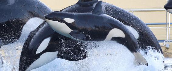
SeaWorld Stock Tanks as "Blackfish" Controversy Cuts Into Profits. Here's an excerpt from AP and
Huffington Post: "
Shares
of SeaWorld Entertainment Inc. (SEAS) fell Wednesday after the theme
park operator reported second-quarter profit and sales that missed Wall
Street expectations and cut its outlook for the year. The Orlando,
Florida-based company also said it believes attendance during the period
was hurt by negative publicity surrounding its treatment of killer
whales, which are trained to perform tricks. A documentary last year
called "Blackfish" suggested that the company's treatment of the killer
whales provokes violent behavior from them, which in turn has led to the
death of trainers..."
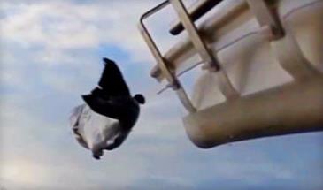
Salmon Canon Fires 40 Fish a Minute.
No, not a new, unfortunate 4th of July custom and much different than a
Salad Shooter. Think fish migration. Here's a clip from
CNET: "...
Artificial
water constructions -- such as dams -- can therefore pose a serious
problem. Fish can become disoriented, or get injured or killed due to
turbines or spillways, and their travel times can get longer due to the
disruption of natural water flow. One solution is the fish ladder,
a structure that is designed to help migratory fish negotiate the
changed waterways. Or you could just fire them through a cannon..."
Photo credit above:
Michelle Starr/CNET.
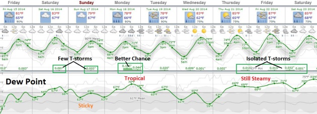
TODAY: More clouds, a few T-storms, best chance south/west Minnesota. Dew point: 64. High: 82
FRIDAY NIGHT: A few T-storms, especially far southern MN. Low: 65
SATURDAY: Hot sun, T-storms by Saturday night. Winds: NE 8. High: 88
SUNDAY: Mix of clouds and sun, cooler with another shower or two. DP: 64. Wake-up: 67. High: 79
MONDAY: Sticky, PM T-storms. Dew point: 68. Wake-up: 69. High: 83
TUESDAY: Some sun, lingering T-shower. Wake-up: 67. High: 84
WEDNESDAY: Intervals of sun, feels like July. Wake-up: 68. High: 86
THURSDAY: High humidity. Steamy sun. DP: 69. Wake-up: 69. High: 88
Climate Stories....
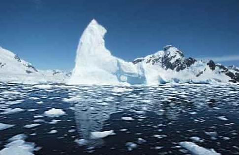
Rising Sea Levels Could Threaten Global Megacities Soon, Says Study. The
rate of ice melt has been faster than climate models predicted 20-30
years ago. When we say we're in uncharted waters, we mean it quite
literally. Here's an excerpt from
International Business Times: "...
Antarctica
was until recently seen as a player only in the long-term. Glaciers in
the Amundsen Sea region contain enough water to raise global sea levels
by 4 feet (1.2 meters), according to a NASA report in May. Another
report in the National Geographic had quoted a recent study that the oceans can rise up
to 6.5 feet (2 metres) by 2100, enough to submerge many cities along
the US East Coast. A complete meltdown of the Greenland ice sheet could
submerge London, it said..."
Global Warming is Moistening The Atmosphere.
The Guardian had a story that confirmed my suspicions; here's a clip: "...
The
authors show that the long-term increase in water vapor in the upper
troposphere cannot have resulted from natural causes – it is clearly
human caused. This conclusion is stated in the abstract,
Our
analysis demonstrates that the upper-tropospheric moistening observed
over the period 1979–2005 cannot be explained by natural causes and
results principally from an anthropogenic warming of the climate. By
attributing the observed increase directly to human activities, this
study verifies the presence of the largest known feedback mechanism for
amplifying anthropogenic climate change.
Heavy Downpours Increasing: Scientists. No
kidding. Wet areas are getting wetter, dry areas drier. Where have you
heard that before? Oh right, the climate models predicted this 30 years
ago. From climate theory to reality. Here's an excerpt from
ABC News: "...
Record-breaking
rain storms like the ones this week, climate scientists say, are
something people should get used to as they continue to warm the planet.
It doesn’t take much warming to have a significant impact on rain
storms. For every one degree of temperature rise, the atmosphere can
hold 7 percent more evaporated moisture, say scientists.
(Temperatures in the U.S. have risen by as much as 1.9 degrees
Fahrenheit since 1895.) “When it rains, it pours,” says Kevin Trenberth,
a scientist at the National Center for Atmospheric Research in Boulder,
Colorado. “Global warming encourages what would have been a normal
rainstorm to become a real downpour and increases the risk of flooding...”


No comments:
Post a Comment