Soaking up Summer
By Todd Nelson
By Todd Nelson
I'm staring cross-eyed at the calendar right now in disbelief that the Fair starts this week... Somebody pinch me! I'm holding on to summer with a firm grip now, but it's slipping fast. I actually heard my first cicada of the year a few days ago and according to legend, the first frost is only 6 weeks away! So I guess I'll mark my calendar for a mid/late September cool snap that'll be nipping the buds off my flowers.
We've actually had a fairly quiet summer. Despite the record rains in June, the severe weather threat and extreme summer heat has been kept to a minimum. According to NOAA, the average (1981-2010) of 90° days is around 11. We've only seen 2 this year! Minnesota has also had 20 tornado reports, which is below the average annual (1991-2010) count of 45.
Big swings in the jet stream have had weather systems stalling across the country this year. The western U.S. has been hot and mostly dry, while the eastern U.S. has been cool and soggy. However, the upper level winds will change later this week bringing with it a surge summery air just in time for the start of the Fair. It looks sweaty next weekend; I guess I'll have to limit my corn dog intake. -Todd Nelson
===========
SATURDAY NIGHT: Lingering shower/storm early. Low: 65.
SUNDAY: Mix of clouds and sun, cooler with another shower or two, mainly in southern MN. High: 77. Winds: ESE 5-10
SUNDAY NIGHT: More clouds, slight chance of an isolated rumble of thunder. Low: 65
MONDAY: Soggier start to the work week. High: 82
TUESDAY: A few afternoon storms bubble up, mainly east. Wake-up: 65. High: 80
WEDNESDAY: Cloudier start, more late day sun. Wake-up: 63. High: 82
THURSDAY: Warm and muggy start to Fair. Wake-up: 66. High: 85.
FRIDAY: Increasing late day thunder chance, mainly western MN. Wake-up: 68. High: 86.
SATURDAY: Sweaty day at the Fair. Spotty PM Storms. Wake-up: 69. High: 86
===========
This Day in Weather History
August 17th
August 17th
1946: A tornado kills 11 people in the Mankato area around 6:52PM. A 27 ton road grader was hurled about 100 feet. Another tornado an hour later destroys downtown Wells.
“The cloud dipped down to the ground when it reached the Minnesota valley, just at the place where the tourist camp was. I came in sight of the camp in time to see three cabins go. They just flew into pieces. When I pulled up, some people were lying around. Others were walking around dazed. We put as many injured into the track as we could and I brought them into town.”
===========
Average High/Low for MSP
August 17th
August 17th
Average High: 81F (Record: 100F in 1947)
Average Low: 62F (Record: 42F in 1962)
Average Low: 62F (Record: 42F in 1962)
============
Sunrise/Sunset Times
August 17th
August 17th
Sunrise: 6:17am
Sunset: 8:16pm
Sunset: 8:16pm
Daylight lost since Summer Solstice (June 21st) ~ 1 hour 38 minutes
==============
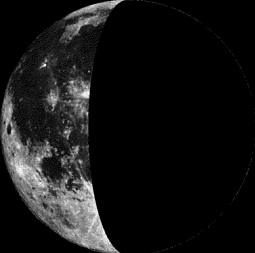
Moon Phase for August 17th at Midnight
0.8 Days After Last Quarter
0.8 Days After Last Quarter
=================
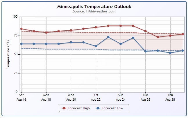
Minneapolis Temp Trend
After a fairly mild Saturday, temperatures will take a bit of a dip Sunday and into early next week. However, there are some indications of a warming trend heading into the end of the week/weekend. If you're planning on heading to the Fair next weekend, it could be quite summery! The less reliable extended forecast is still suggesting a bit of a cool down later in the month.
===================
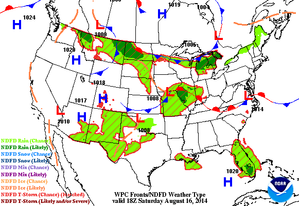
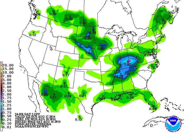
Weather Outlook
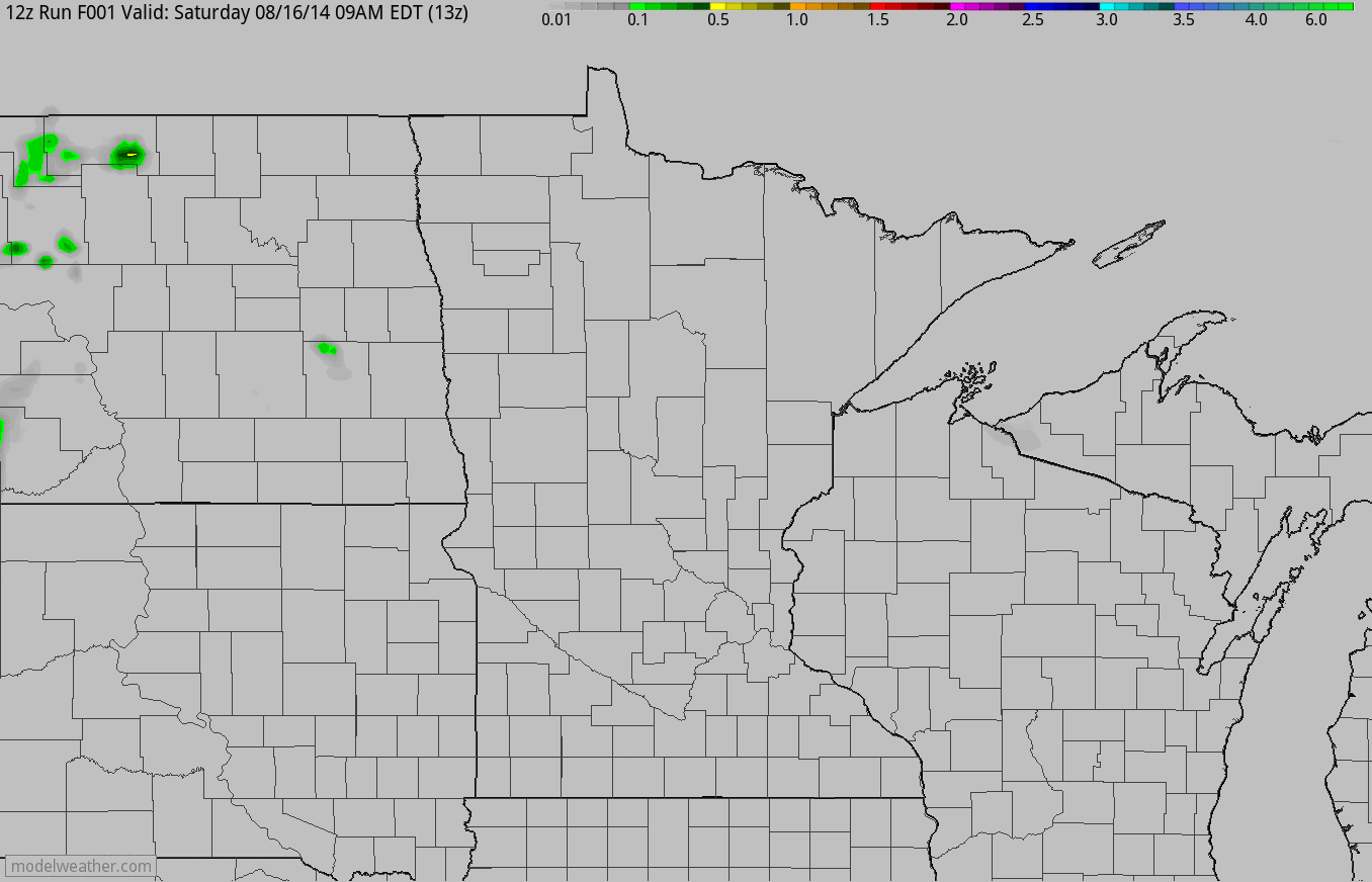
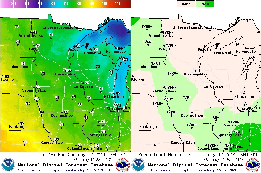
Check out the precipitation outlook from AM Saturday through PM Monday and note the 'heavier' pockets of rain that pop up over the state through the rest of the weekend (not a washout). Some of the showers and storms that develop yet through the end of the weekend could produce isolated areas of heavy rainfall. However, the best chance of heavier and more widespread rainfall comes in early next week, Monday especially.
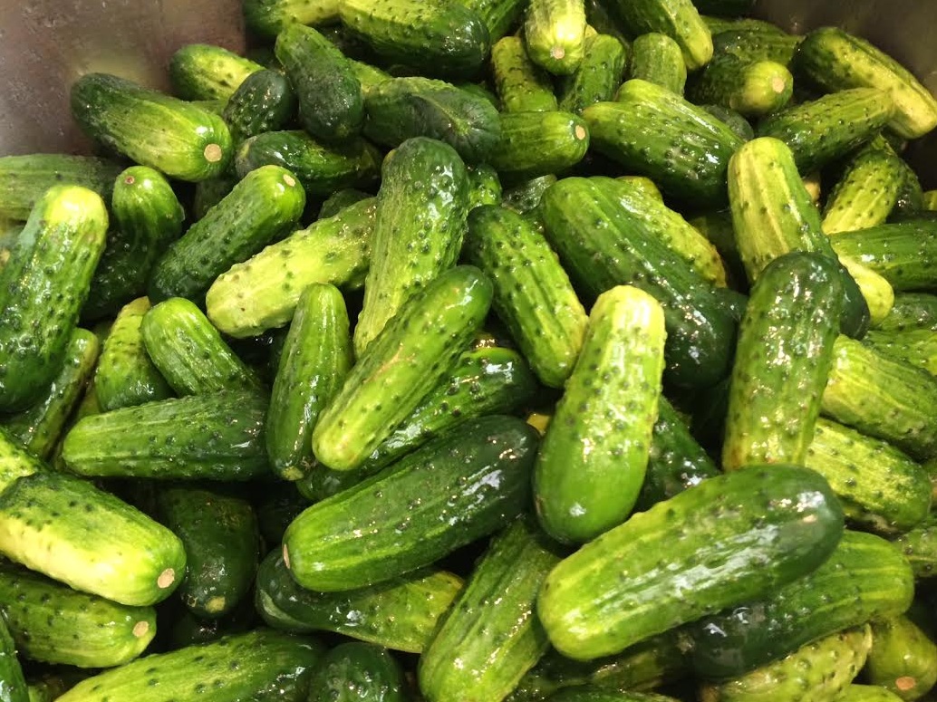
Pickle Pack 2014
One of my favorite memories as a young kid was pickle packing day with the family at Grandma's house! It started early in the morning with a trip to the Farmers Market and ended with dozens and dozens of beautiful jars of pickles that we divvied up between the family. As everyone got older and busier, we quit one of my favorite family traditions. A few years ago, I got into canning and brought the tradition back! Yes, it can be a long and tedious job, but in the dead of winter, there's nothing better opening a jar of something you worked hard to preserve from the summer before!
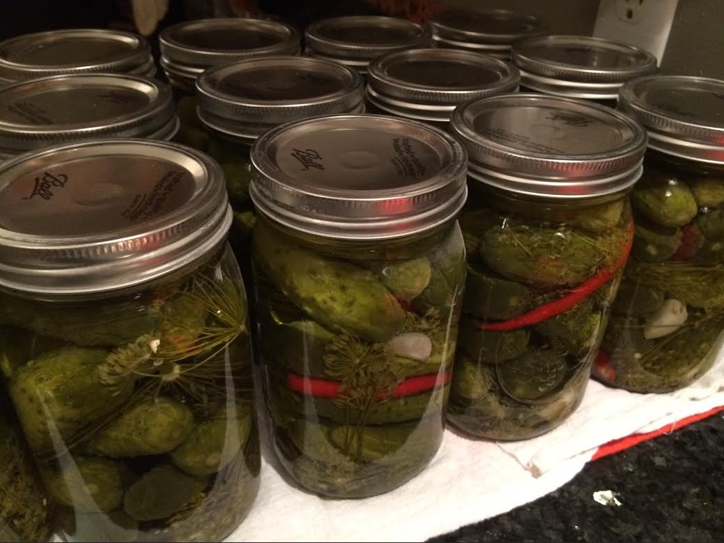
If you're interested, here's my Grandma's recipe that I'm sure you'll enjoy:
After you've sanitized all your jars/lids/etc., pack your pickle jars with fresh dill, garlic and some peppers. In each jar we use:
1 to 2 sprigs of dill at bottom (depending on size)
1 to 2 cloves of garlic at bottom (depending on size)
1 slice of Jalapeno or thai chili at bottom (depending on your heat tolerance, add little to none or more if you'd like)
Start (tightly) packing pickles in your jar and in the middle or near the top add one more sprig of dill, 1 more clove of garlic and perhaps even some additional peppers (if you like them HOT)! According to the Scoville Scale, thai chili peppers are hotter than jalapenos so use caution and don't add if you don't like spicy pickles, but I LOVE the look of the red thai chili after you've canned!

Pickle Brine:
1 quart of white vinegar
3 quarts of water
1 cup sugar
1/2 cup (kosher/canning) salt
Bring to boil & stir until all salt/sugar has dissolved. Fill your packed jars with brine and leave about 1/2" to 1" head room. In your water bath canner, submerge and process for recommended time (based on your altitude). Then, take out of water bath and set on counter and let the sealing process continue... You should start to hear little 'pings' or 'clicks' as jar/lid seals - this is one of my favorite sounds while canning! Wait about 6 weeks to 2 months and eat away!!
There is a big procedure to canning, so make sure to read more on how to correctly process food safely. HERE is a quick pickle processing link from the Colorado State University:
Enjoy and let me know if you get a chance to try the recipe!
Sunday Weather Outlook
Sunday will definitely be a cooler day across the region, especially near the shores of Lake Superior. The front that sparked spotty showers/storms on Saturday, will drift south and stall from the Dakotas through Iowa and generally keep any lingering showers/storms in that area for Sunday.
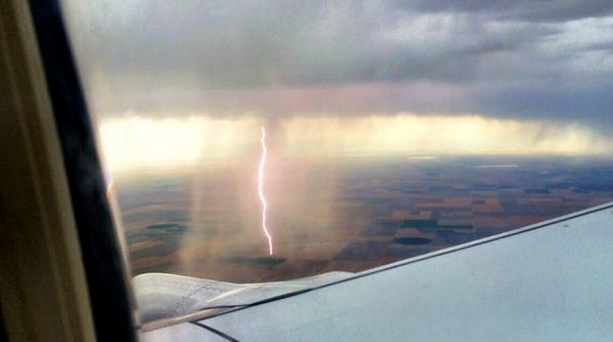
Close Call...
Thanks to @Labelldame for this incredible photo near Denver, CO in late July!
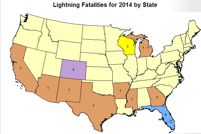
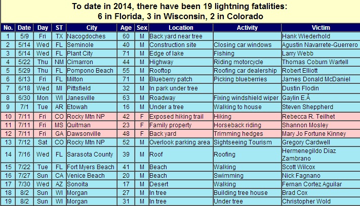
2014 Lightning Deaths
According to NOAA, there have been 19 lightning deaths this year (average per year is 51). The state with the most lightning deaths this year is Florida with 6, but Wisconsin has had 3 deaths this year!
The National Weather Service has coined the term: "When thunder roars, go indoors!" Keep in mind that if you can hear thunder, you are within striking distance!
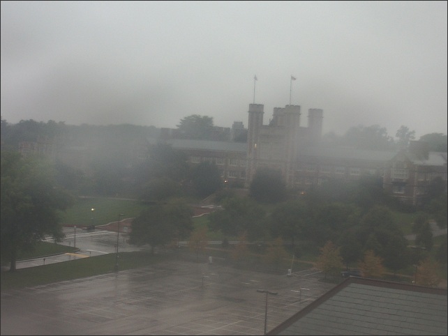
Soggy St. Louis
It was a very wet start to the day in St. Louis on Saturday. The image below from Washington University AM Saturday showed the soggy scene. St. Louis will be an area that could see significant rainfall through early next week.
Weather Outlook
The impulse of energy responsible for the heavier rain in the midsection of the nation on Saturday, will continue to slowly push into the Ohio Valley on Sunday with additional heavy rainfall potential.
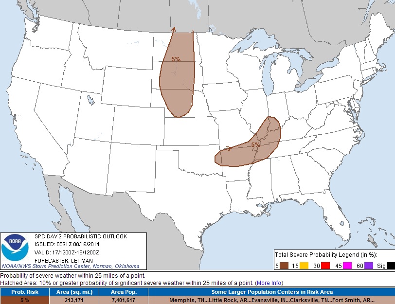
Sunday Thunderstorm Potential
According to NOAA's SPC, there will be an enhanced thunderstorm risk across parts of the Dakotas and also in the middle of the country. Although there doesn't appear to be a widespread severe weather threat on Sunday, a few strong to severe storms could pop up with gusty winds and large hail.
Sunday Rainfall Potential
According to NOAA's HPC, the rainfall potential for Sunday looks quite heavy across parts of the Ohio Valley. Some spots near Cincinnati could see 1" to 2" from AM Sunday to AM Monday
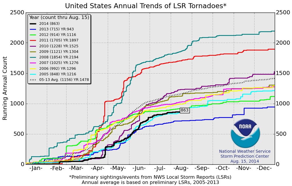
U.S. Tornado Count Through August 15th
According to NOAA's SPC, the PRELIMINARY 2014 U.S. tornado count of 863 is running below the 2005-2013 average of 1,156. 2011 and 2008 were very active years for tornadoes. In fact, at this time during those years, there had been more than 1,700 preliminary tornado reports. 2008 ended up with more than 2,000 preliminary tornado reports for the year.
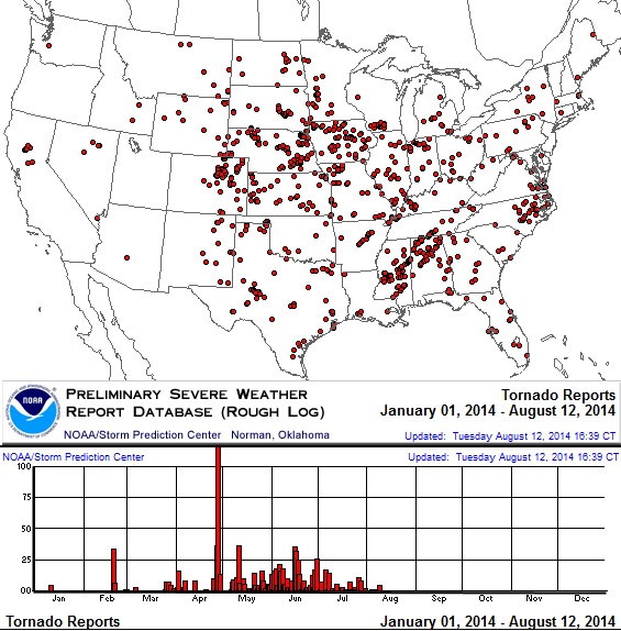
2014 Tornado Reports
Here's a map of all the PRELIMINARY tornado reports across the country so far this year. April 28th was the most active tornado day this year with 121 reports across the Gulf Coast States where several people lost their lives. 8 different tornadoes during the month of April killed 35 people this year. In 2011, there were 43 different tornadoes that killed more than 300 people in some of the same areas.
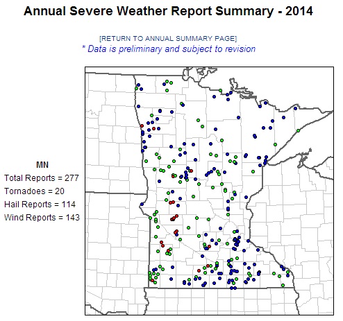
Minnesota Tornado Count
According to NOAA's SPC, there have been 20 PRELIMINARY tornado reports this year across the state. Keep in mind that according to NOAA's NCDC, the average number of tornadoes per year in Minnesota (1991-2010) is 45. Through the rest of the year, MN would typically average 6 more tornado reports. June and July are the most active months averaging 18 and 12 tornadoes respectively.
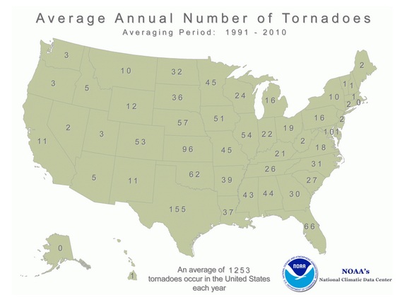
Average Annual Number of Tornadoes
According to NOAA's NCDC, the average annual number of tornadoes (1991-2010) for Minnesota is 45. Nationwide, that number is 1,253 with the greatest number of tornadoes in Texas. Texas, by the way, has seen only 58 tornado reports this year and averages about another 32 reports through the rest of the year, which would still put them below average by nearly half.
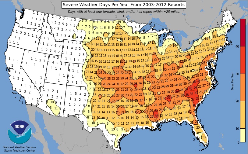
Average Number of Severe Weather Days
This is kind of an interesting map. It shows the average number of severe weather days from 2003-2012. Note that some of the most active areas have been in the Southeastern U.S.. Minnesota ranges from a couple of severe weather days per year in the northeastern part of the state to as many as 15 to nearly 20 across the southern half of the state.
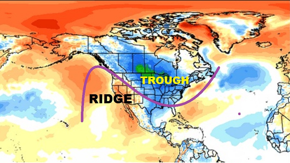
Cooler Than Average Temperatures
One reason for the lack of excessive tornadoes this year in the central and eastern part of the country may be due to the fact that there has been a near persistent weather pattern so far in 2014. The image below suggests the temperature anomaly thus far in 2014. The warmer oranges/reds have been quite common due to a near persistent ridge of high pressure in the western U.S. keeping things mostly dry and mostly warm. Meanwhile, the eastern two-thirds of the country has been cooler than normal due to frequent/stationary troughs of low pressure. In 2011, the upper level winds were nearly reversed with a trough of low pressure in the western U.S. with a ridge of high pressure in the eastern U.S.. This helped to allow several storm systems to track from southwest to northeast across the country, especially in the spring. The 2011 weather pattern was more active and thus more conducive for tornadic activity.
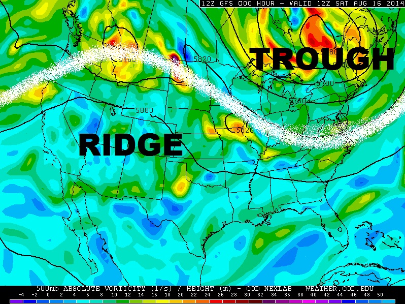
Persistent Pattern
This is what the 500mb vorticity map looked like AM Saturday. Note the near similar look the weather pattern now to what we've seen nearly the entire year thus far. When certain weather patterns set up, it tends to be hard to break out of those patterns. Hot/dry weather patterns or cool/rainy weather patterns can lingering for several days/weeks, before something mixes that up.
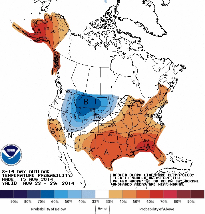
Temperature Outlook
According to NOAA's CPC, the 8 to 14 day temperature outlook (August 23-29) shows a slight change in what we've been dealing with. Note that chances of cooler than average temperatures will move into the Northwest, while chances of warmer than average conditions move into the eastern two-thirds of the nation. This could potentially be a setup for a little more thunderstorm activity in the central U.S.
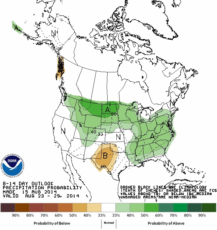
Precipitation Outlook
According to NOAA's CPC, the 8 to 14 day temperature outlook (August 23-29) suggests chances of above normal precipitation returning to parts of the High Plains/Midwest and Southeastern U.S.
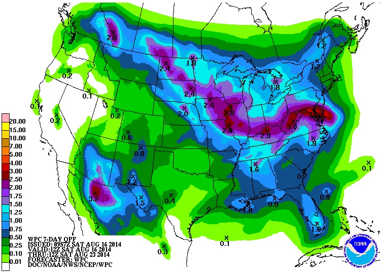
7 Day Rainfall Potential
According to NOAA's HPC, the 7 day rainfall potential suggests a fairly decent swath of moisture from the High Plains to the Ohio Valley from AM Saturday to AM Saturday (next weekend). Some of this heavier rainfall potential could cause some flooding concerns, but for areas that have been dry as of late, some of this moisture could help with the lawns and gardens!
Celestial Happenings
The Solar Dynamics Observatory recorded an Earth directed CME (coronal mass ejection) on Friday, which means that northern latitude sky watchers should be on the lookout for northern lights. The lights may be visible as early as Sunday night through Monday!
"A magnetic filament snaking down the middle of the solar disk erupted during the late hours of Aug. 15th. The eruption split the sun's atmosphere, hurling a CME toward Earth and creating a "canyon of fire," shown here in a movie recorded by the Solar Dynamics Observatory:"

Northern Lights
Here's a neat site that I found that has a lot of neat tools to help you identify when the northern lights may be active. www.rossellet.com has put together this Aurora Tracker has a number of great links that can help/teach you a little more about the phenomenon.
Thanks for checking in and have a great rest of your weekend! Don't forget to follow me on Twitter @TNelsonWNTV

No comments:
Post a Comment