By Todd Nelson
"Summer breeze, makes me feel fine." Ahh, the faint hum of a distant lawn mower and the occasional buzz of a covert cicada are sounds I wish I could bottle up now and open during a cold dark January day.
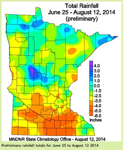
Who could forget the soaked, mosquito-ladened start to our summer... Good grief, you could barely go outside without getting eaten alive by those bloodsucking beasts! June was the wettest on record for the state. Minneapolis had it's 2nd wettest June on record with 11.36" of rain, only 0.31" behind the wettest on record set in 1874! Since then, we've endured 7 weeks of dry weather. In fact, according to the State Climatology Office, "parts of southern MN have had one of its driest June 25 to August 12 periods on record! Most of central and southern MN are nearly 2" to 5" below normal rainfall."
The weekend appears to be somewhat unsettled with spotty thunder chances bubbling up during the afternoon/evening hours. However, early next week could bring a little more relief for lawns and gardens.
We will dry out just in time for the start of the MN State Fair Thursday. Mild temps and a hint of summer humidity will be served on a stick late this week.
==============================
FRIDAY NIGHT: A few T-storms, especially far southern MN. Low: 65
SATURDAY: Sticky sun, T-storms by afternoon/evening. Winds: ENE 5-10. High: 86
SATURDAY NIGHT: Lingering shower/storm early. Low: 62.
SUNDAY: Mix of clouds and sun, cooler with another shower or two, mainly in southern MN. High: 78
MONDAY: Soggier start to the work week. Wake-up: 62. High: 80
TUESDAY: A few afternoon storms bubble up. Wake-up: 65. High: 80
WEDNESDAY: Cloudier start, more late day sun. Wake-up: 65. High: 82
THURSDAY: Warm start to the MN State Fair. Wake-up: 66. High: 84.
FRIDAY: Increasing late day thunder chance. Wake-up: 65. High: 84.
============================
This Day in Weather History
August 16th
1981: Chilly across Minnesota with Tower reporting a low of 33 degrees.
===========================
Average High/Low for MSP
August 16th
Average High: 81F (Record: 99 in 1988)
Average Low: 62F(Record: 47 in 1962)
===========================
Sunrise/Sunset Times
Sunrise: 6:16am
Sunset: 8:17pm
===========================
Moon Phase for August 16th at Midnight
1.2 Days Before First Quarter
=============================
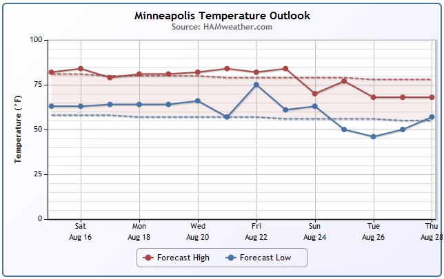
Minneapolis Temp Trend
A quick glance at the temperature trend below for MSP, guidance suggests that we hover just above average highs over the next several days with a slightly warmer trend toward the end of next week. The somewhat less reliable extended forecast suggests cooler conditions moving in for the first full week of the MN State Fair.
===========================
2014 Fair Foods
Thanks to www.MNStateFair.org for a look at the NEW 2014 Fair Foods!! With the start of the fair quickly approaching, my taste buds are going through withdrawals. I've got my eyes set on the French Toast PB&J at the Robbinsdale OES Dining Hall!

See the new fair foods HERE:

Great Day for Golf!
Thanks to my brother-in-law Wade for the image below from the 1st fairway at Baker National Golf Course. What a stunning day for golf it was on Friday!

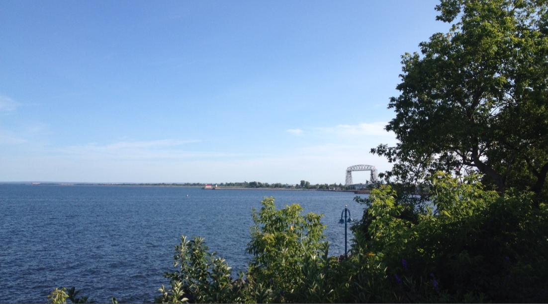
Duluth, MN
Another stunning image from Duluth, MN. Thanks to my good friend Susie Martin for the picture and have a great time!
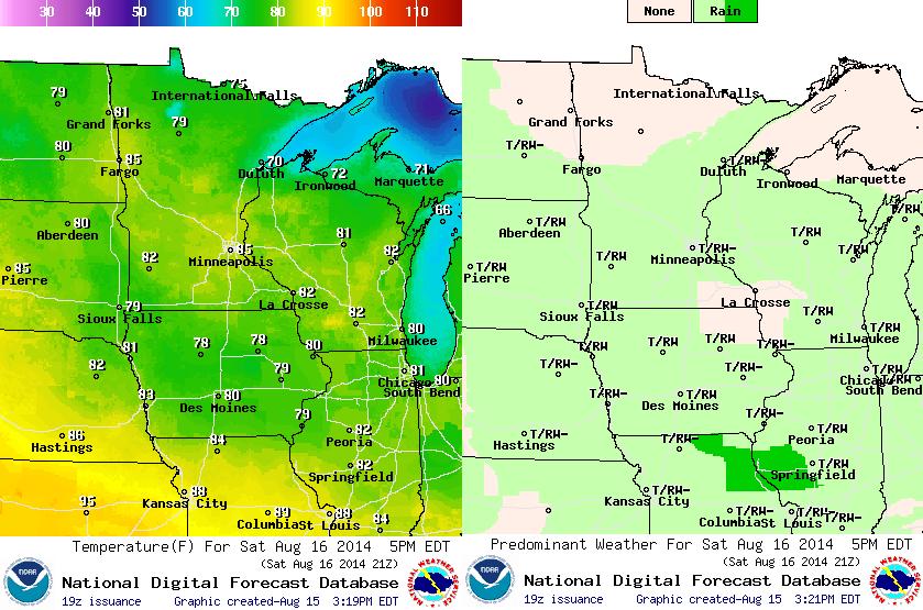
Saturday Weather Outlook
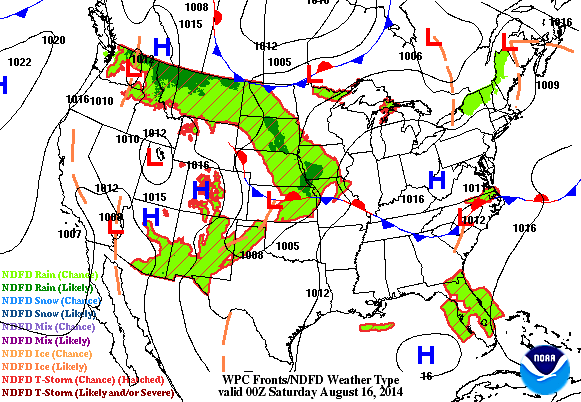
It'll be a warm and summery Saturday with temps in the mid 80s across the central and southern part of the state. Northern MN will be cooler with highs in the mid/upper 70s as a cool front slides in from Canada. This front will also kick off a few isolated afternoon showers/storms with perhaps a few heavy downpours here or there.
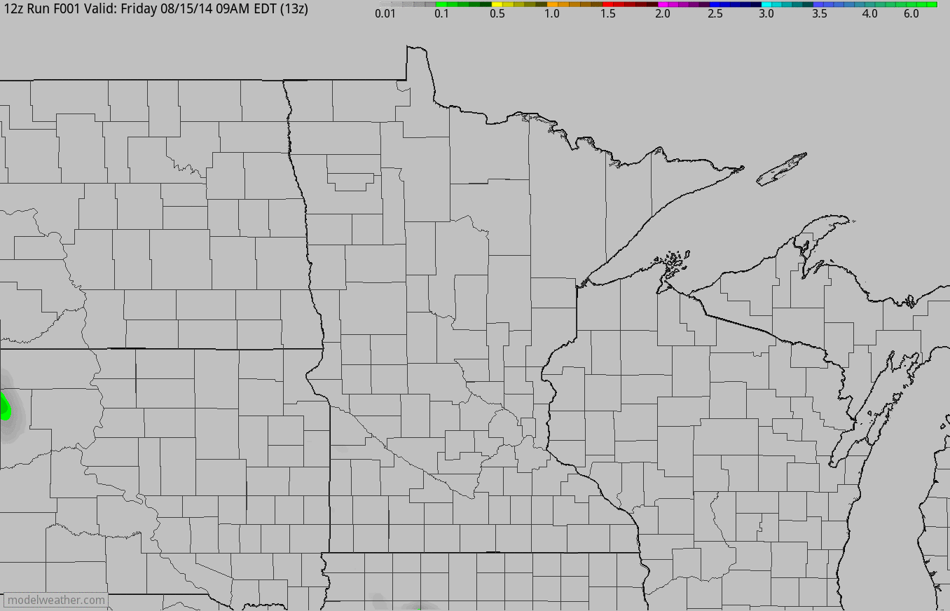
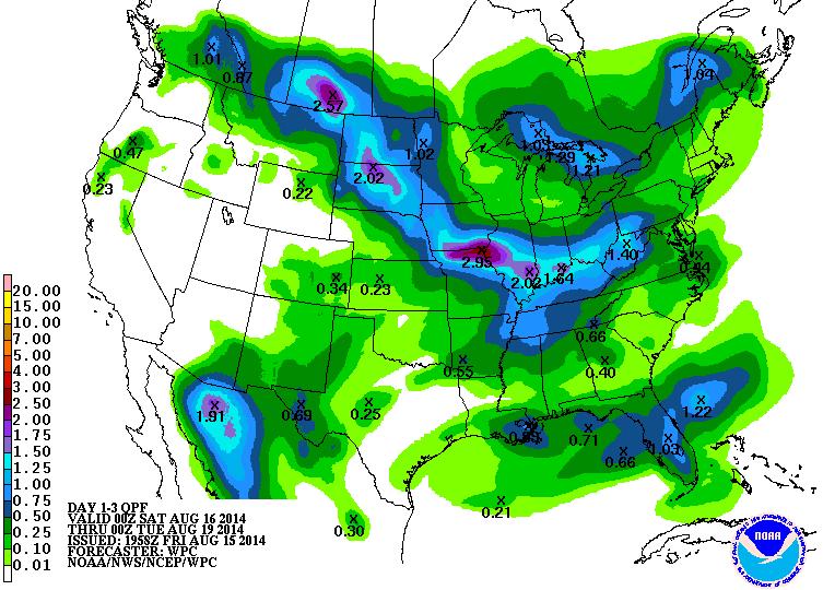
Weather Outlook
The loop below suggests the accumulated precipitation from AM Friday through PM Sunday. Note that the entire state is not expected to get a washout, but there could be pockets of heavy rain with any of the spotty thunderstorms that pop up. Some of the heaviest rain will be found across South Dakota and perhaps across southern Minnesota.
Dry Weather
No doubt, the start of our summer was extremely wet! In fact, June was considered to be the wettest on record for the state. Minneapolis saw it's 2nd wettest June with 11.36" of rain, the wettest was set in 1874 at 11.67". For the past 7 weeks, we've been extremely dry across much of the state. Lawn and gardens have been struggling quite a big unless you've been diligently working on your sprinkler skills. I know my lawn looks a little stressed/brown and my flowers have looked better. According to the MN State Climatology Office, parts of central and southern MN are nearly 2" to 5" below average rainfall from June 25th to August 12. Parts of southern MN have actually had one of its driest June 25 - August 12 periods on record!
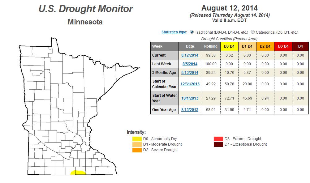
"The Dog Days of Summer occur roughly from July 3 to August 11 timed with the appearance of the "Dog Star" Sirius. The 2014 "Dog Days" have been characterized by a long stretch of dry weather and generally mild temperatures. The last seven weeks have been dry. In fact, from June 25 to August 12 most of central and southern Minnesota was from two to five inches short of normal. As of August 12, the Drought Monitor shows that a small area of south central Minnesota has been categorized as "Abnormally Dry"."
Read more from the MN State Climatology Office HERE:
Minnesota Drought Monitor
According to the U.S. Drought Monitor, due to the recent dry weather, a little sliver of southern MN has once again been put back into "Abnormally Dry" conditions. However, the rest of the state is drought free.
Here's a blurb from the U.S. Drought Monitor about our recent dry weather:
"However, in areas that missed the heavier precipitation, some areas of abnormal dryness were introduced, specifically in western Nebraska, western South Dakota, southwestern Wisconsin, north-central Iowa and adjacent Minnesota, and north-central Missouri. These areas generally received well under half of normal rainfall since mid-July, and 60-day shortages of 2 to almost 4 inches affect north-central Missouri, north-central Iowa and adjacent Minnesota, and southwestern Wisconsin."
Read more from the U.S. Drought Monitor HERE:
National Weather Outlook
Looking at the national weather from PM Friday through PM Sunday, note the next bubble of high pressure sliding into the Great Lakes Region. This is will help to push most of the heavier rainfall potential from the Dakotas into Iowa. This has been a fairly common occurrence over the last several weeks with most of Minnesota missing out of some of the heaviest rainfall potential. These high pressure bubbles tend to bring a glancing blow of slightly cooler than normal temperatures. You'll notice a slightly cooler/less humid air mass moving in by Sunday.
Precipitation Outlook
According to NOAA's HPC, the 3 day precipitation outlook suggests the heaviest precipitation across the Midwest bypassing Minnesota by way of the Dakotas to Iowa and eventually down into the Ohio Valley. Thanks to an area of high pressure sliding into the Great Lakes Region, most of the heavy rainfall potential will be blocked from making it into the Upper Mississippi Valley through much of the weeend.
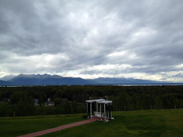
I See Russia!
Thanks to my good friend and colleague, Bryan Karrick for the image below who is on an amazing trip across Alaska. Here's a more recent photo from Wasilla, AK where you can actually see Russia! Thanks Bryan! Have a great time!
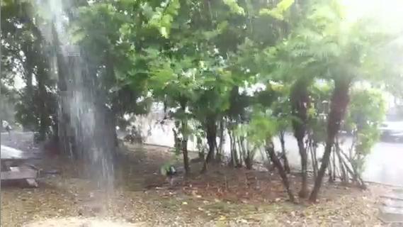
Heavy Rain in Florida
Thanks to my good friend Bay Scroggins for the image below out of Doral, FL where heavy rain fell earlier this week. Interestingly, there were a number of significant rainfall records last week from the Ohio Valley to the Great Lakes and into the Northeast.
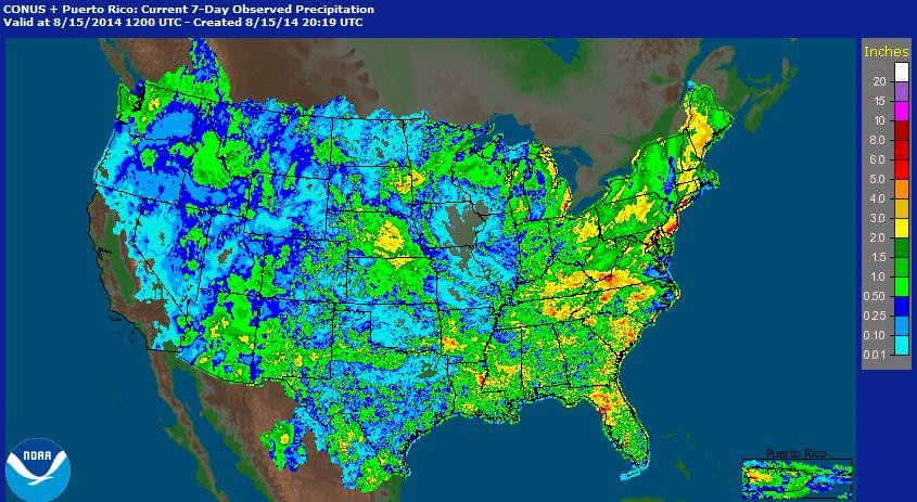
Significant Rainfall Past 7 Days
There were several rainfall records last week as a slow moving storm system crossed through the eastern half of the country. Note all the big red blobs, which indicate near 5" of rain or more.
Here are some of the more impressive rainfall records from the last several days.
Lexington, KY: 5.38" (Sunday, August 10th) - (2nd wettest August day in history)
Detroit, MI: 4.57" (Monday, August 11th) - (Read more on historic flooding HERE)
Baltimore, MD: 6.30" (Tuesday, August 12th) (2nd wettest day in history)
Islip, NY: 13.51" (Wednesday, August 13th) (Wettest 24 hour period in NY State history)
The Landscape of a Comet
Here's an interesting look at a comet from close range.
"On August 6th, Europe's Rosetta spacecraft rendezvoused with Comet 67P/Churyumov-Gerasimenko and began to fly alongside it. Seven days later, mission scientists released this spectacular view of the comet's double-lobed core. A closer look reveals many interesting features: While the comet's head (in the top half of the image) is scored with parallel linear features, the neck is peppered with boulders resting on a smooth underlying terrain. In comparison, the comet's body (lower half of the image) is jagged and dimpled by crater-like depressions. Now imagine this magnificent landscape ruptured by dozens of geysers spewing dust and gas into space. Future pictures may show exactly that. Rosetta will follow this comet for more than a year as it approaches the sun. In 2015, if not sooner, solar heating will activate the comet's icy core, creating a riot of activity the likes of which no spacecraft has ever seen before. Stay tuned for that."
See more from Spaceweather.com HERE:

Thanks again for checking in and have a great weekend ahead! Don't forget to follow me on Twitter @TNelsonWNTV

No comments:
Post a Comment