
Back to School
By Todd Nelson
While some schools have already settled in to a daily routine, most will be just getting underway today. Morning commutes will be a little more hectic as you follow around those yellow school buses making frequent stops. With that said, as the sun angle gets a little lower every morning, it'll be a little harder to see any youngsters darting across the road to catch the bus... Take it slow and pay attention!
On Monday, we welcomed Meteorological Fall, which marks the date when the warmest 3 months (on average) are behind us. The Autumnal Equinox is quickly approaching too; only 3 weeks away! Get this, we've lost nearly 2 hours and 20 minutes since the Summer Solstice and we'll lose yet another hour or so by the Equinox on the 22nd!
Our average high dips below 70F by the end of the month, so changes happen quickly...
While I hate saying goodbye to my garden and summer pools, I have come to realize that Fall is one of my favorite times of the year for other reasons. Lower humidity, less bugs and enjoying those brilliant fall colors on crisp mornings with a steaming hot cup of joe! MN has a lot to offer with the changing season, but blink & it's gone!
==================
TUESDAY: Partly sunny, less humid. Dew point: 55. High: 78. Winds: SW 5-10
TUESDAY NIGHT: Partly cloudy, still quiet. Low: 62.
WEDNESDAY: Warmer and stickier, fading sunshine with PM Storms. Dew point: 70. High: 84
THURSDAY: Breezy and unsettled with spotty storms. Dew point: 68. Wake-up: 71. High: 82.
FRIDAY: Cooling trend, refreshing breeze. Wake-up: 59. High: 72
SATURDAY: Sunny, hint of Fall in the air. Dew point: 47. Wake-up: 54. High: 70
SUNDAY: AM light jackets, PM sunglasses. Wake-up: 53. High: 73
MONDAY: More clouds with scattered PM storms. Wake-up: 58. High: 75.
=====================
This Day in Weather History
September 2nd
1996: Approximately 8" of rain fell over 2 1/2 hour period in the Mankato area resulting in flash flooding. Numerous road were closed, basements flooded and $100,000 of damage from a lightning strike in Lehiller.
1992: Severe weather affected several counties in the western parts of the County Warning Area. Several tornadoes were reported along with 3/4 inch hail and damaging winds as the system passed through Pope, Swift, Stearns, Kandiyohi, Meeker, Brown and Renville Counties.
1975: Severe weather rolled through Stevens, Swift, Kandiyohi, and Meeker counties. 1.50 inch Hail was reported in Stevens and Swift. An F1 tornado also occurred in Swift at the time that the hail was reported. An hour later another F1 Tornado was reported in Kandiyohi County while 69 knot winds occurred in Meeker County. Damages were estimated at $50,000 for the two tornadoes that touched down.
1937: Severe thunderstorms over northern Minnesota, with 4.61 inches of rain dumped on Pokegama. Flooding was reported in Duluth.
=======================
Average High/Low For MSP
September 2nd
Average High: 77F (Record 97 set in 1937)
Average Low: 58F (Record 42 set in 1974)
========================
Sunrise/Sunset Times
September 2nd
Sunrise: 6:36am
Sunset: 7:48pm
=========================
Moon Phase for September 2nd at Midnight
0.2 Days Before First Quarter

=================================
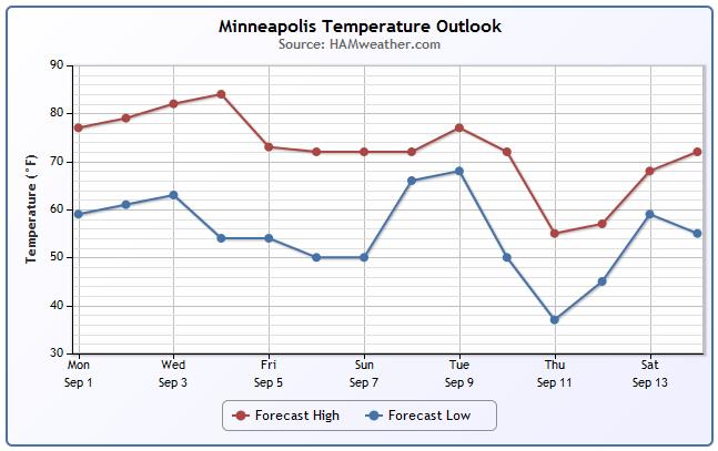
Minneapolis Temperature Trend
As we head back to the grind after the long Labor Day weekend, weather conditions will be rather quiet. However, a storm system moves in by midweek with more summer humidity and storms. Post front, we see a rather significant drop in temps and humidity by the upcoming weekend. In fact, there will be a hint of Fall in the air!
================================
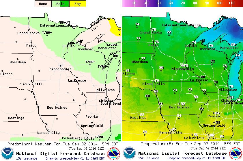
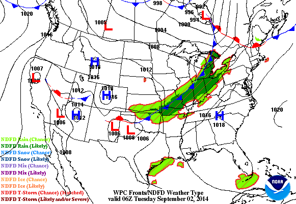
Tuesday Weather Outlook
Tuesday looks rather pleasant as a few lingering showers drift east along the northeastern part of the state through the day. We warm up close to 80F in the southwestern part of the state with highs in lower 70s across the northern part of the state.
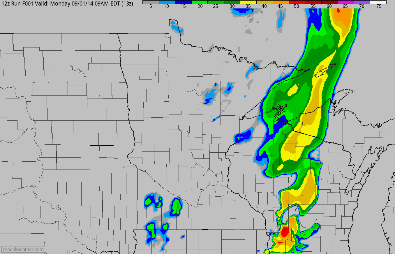
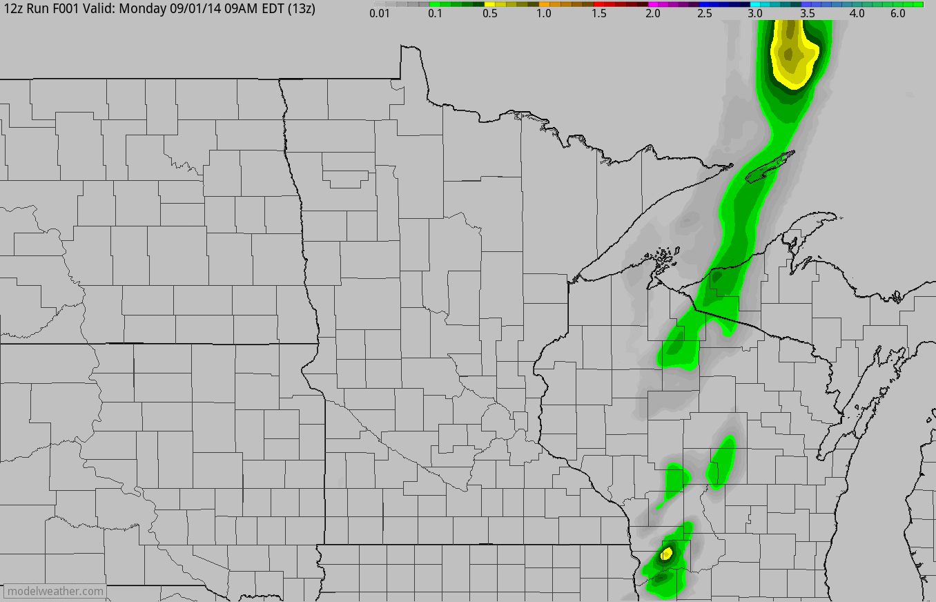
Weather Outlook (AM Monday - AM Wednesday)
The loops below show the simulated radar and accumulated precipitation potential from AM Monday through PM Wednesday. There will be a few spotty showers across the northern part of the state on Tuesday, while the next best chace of heavier rain/thunder moves in by midweek.
Weather Outlook
It'll be a fairly quiet start as we head back to work, but the next storm that rolls in by midweek bring a chance of showers and storms.
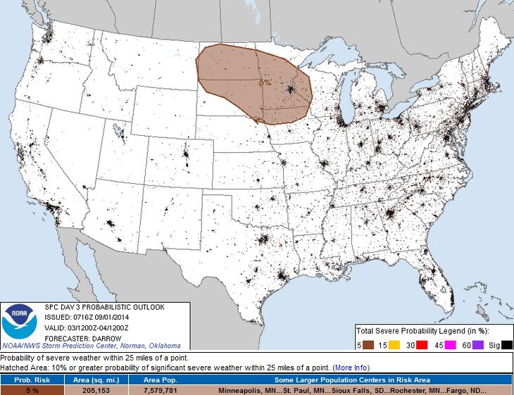
Severe Threat Wednesday
Our next chance of showers and storm by midweek brings with it a chance of strong to possibly severe storms. stay tuned!
Thanks for checking in and have a great week ahead! Don't forget to follow me on Twitter @TNelsonWX

No comments:
Post a Comment