"A
low pressure system will move across the area on Wednesday and
Thursday, and bring the chance for strong to severe thunderstorms across
much of the area. Warm temperatures on Thursday will be reduced into
the 60s and 70s for highs on Friday in the wake of the cold front. Cool
and dry, autumn-like weather will then prevail for the upcoming
weekend."
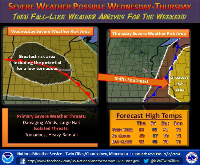
Growing Severe Risk
By Todd Nelson
As daylight continues to dwindle in the Northern Hemisphere, a cold pool of air begins to grow and intensify. This expanding blob tightens the temperature gradient from north to south, which stimulates the upper level winds. This energetic wind field tends to whip up more fequent and volatile storms and that's something we may be seeing more of in the future.
One of these said storms will meander into our neck of the woods today. Humidity values will spike to stickier levels and ignite strong to severe storms this afternoon. Watches/warnings may be issued later Wednesday, so stay tuned.
Lingering storms shake out some of the humidity by late Thursday. You'll notice a much more refreshing breeze by Friday... in fact, there will be a hint of Fall in the air by the weekend!
Apple picking season has commenced in some locations, so it might not be a bad idea to check out your local orchard this weekend. You can stock up on your favorite pie apples and start baking away! Just make sure you invite me over for a large slice, though I'll be busy on Sunday watching the Vikes lock horns with the Rams in the first regular season game. Yes, it's Fall! -Todd Nelson
================
TUESDAY NIGHT: Partly cloudy, still quiet. Low: 61.
WEDNESDAY: Warmer and stickier, fading sunshine with PM Storms. Dew point: 70. High: 84. Winds: SSE 10.15
WEDNESDAY NIGHT: Thunderstorms likely, some strong to severe. Low: 72
THURSDAY: Breezy and unsettled with spotty storms. Dew point: 68. High: 84.
FRIDAY: Cooling trend, refreshing breeze. Wake-up: 55. High: 70
SATURDAY: Sunny, hints of Fall in the air. Dew point: 47. Wake-up: 53. High: 71
SUNDAY: AM light jackets, midday couch/football patrol. Wake-up: 52. High: 72
MONDAY: Gray skies return. Spotty thunder potential. Wake-up: 55. High: 74.
TUESDAY: Unsettled. More humid. Wake-up: 56. High: 77.
=================
This Day in Weather History
September 3rd
1989: An early afternoon thunderstorm dropped 1 3/4 inch hail in Stearns and Morrison Counties.
1980:
An F2 tornado resulted in $2.5 million in property damage later an F3
touched down causing $25 million in damages in Stearns County.
1970:
The record-setting hailstone fell that made Coffeyville, KS famous. It
had a circumference of 17.5 inches and weighed 1.67 pounds.
1917: Earthquake felt from Staples to Brainerd.
=====================
Average High/Low for MSP
September 3rd
September 3rd
Average High: 77F (Record 97F set in 1925)
Average Low: 58F (Record 32F set in 1974)
Average Low: 58F (Record 32F set in 1974)
=====================
Sunrise/Sunset Times for MSP
September 3rd
September 3rd
Sunrise: 6:37am
Sunset: 7:46pm
Sunset: 7:46pm
=====================
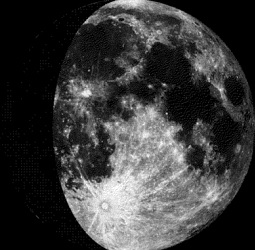
Moon Phase for September 3rd at Midnight
1.8 Days Since First Quarter
1.8 Days Since First Quarter
=======================
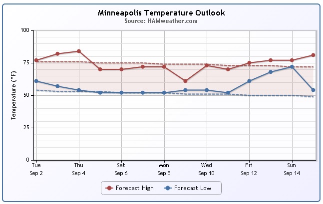
Minneapolis Temperature Trend
It'll
be warm and sticky into mid week as a storm system approaches.
Thunderstorm potential becomes more interesting on Wednesday as indices
point to strong to severe potential! Post front, temperatures drop to
more 'fall-like' readings into the weekend.
===========================
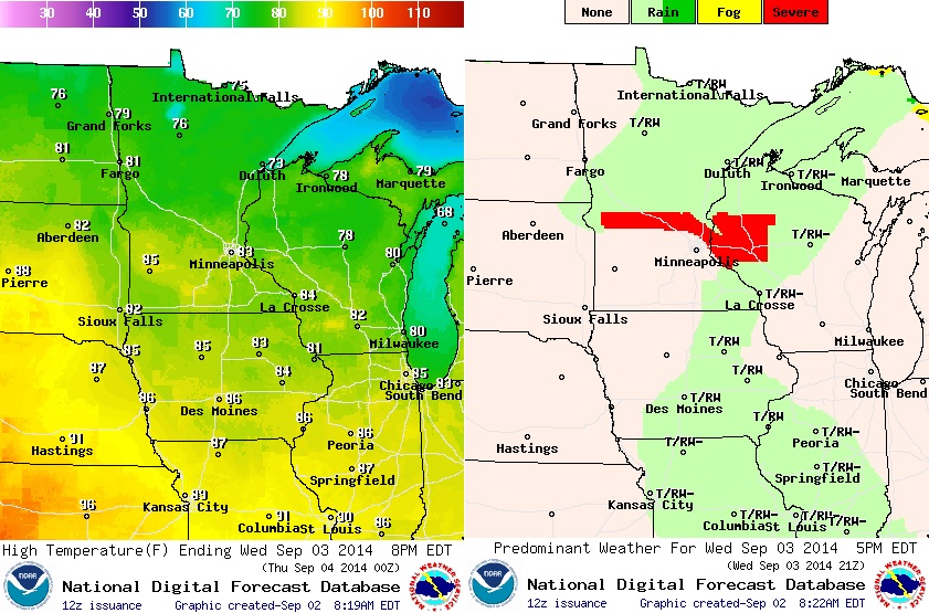
Wednesday Weather Outlook
We
haven't had many hot days this summer and it doesn't appear any hot
days are in order for the first half of September. We do warm up a bit
on Wednesday. Temperatures will slide into the low/mid 80s across the
southern half of the state, while folks in the northern part of the state
warm into the mid 70s. Dew points will also be on the rise and hover in
the upper 60s to near 70 by the afternoon, which will be nearly
tropical feeling. With the heat and humidity builiding out ahead of a
cool front, showers and thunderstorms could turn strong to severe later
in the day. The image on the right suggests severe potential by the
afternoon/evening hours.
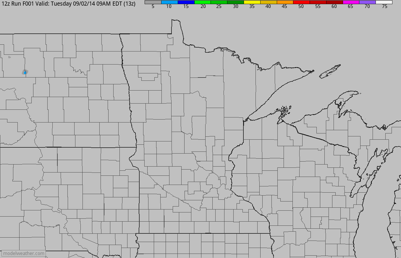
Simulated Radar/Accumulated Precipitation Potential
The
simulated radar reflectivity from AM Tuesday through PM Thursday
suggests strong to severe storm potential by PM Wednesday. Hail and high
wind potential could certainly be a big concern along with isolated
pockets of heavy rain/flash flood concerns.
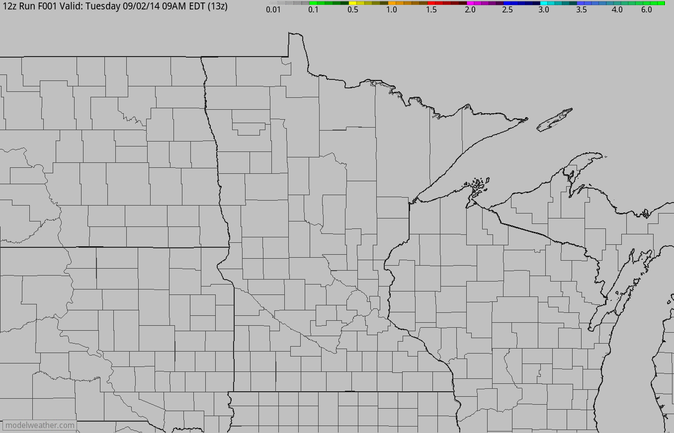
The
accumulated rainfall potential from AM Tuesday through PM Thursday
suggests heavier rain in central Minnesota and into west-central
Wisconsin.
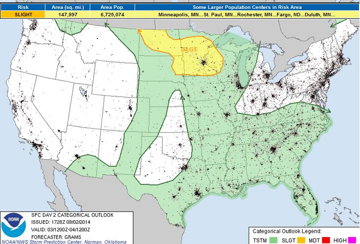
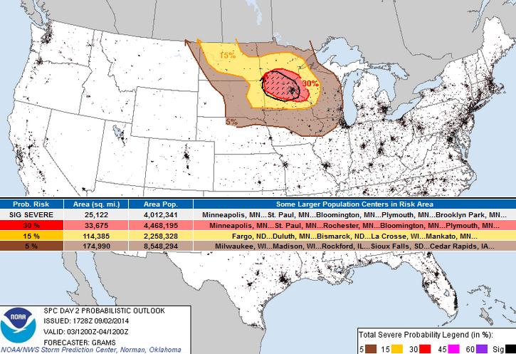
Severe Threat Wednesday
According
to NOAA's SPC, the severe threat on Wednesday is greatest over the
Upper Mississippi Valley. A front splashing out of Canada will promote
thunderstorm development in the PM hours with hail and high winds being
the primary threat.
A
CLUSTER OF ELEVATED TSTMS SHOULD BE ONGOING AT 12Z/WED ACROSS PARTS OF
THE SIOUXLAND DRIVEN BY LOW-LEVEL WAA WELL N OF THE SURFACE FRONT. THIS
CONVECTION MAY BE SUSTAINED THROUGH THE MORNING ACROSS PARTS OF
CNTRL/SRN MN WITH A MARGINAL HAIL RISK ON THE FRINGE OF LARGER BUOYANCY.
THIS ACTIVITY SHOULD YIELD A PRONOUNCED DIFFERENTIAL HEATING CORRIDOR
AS STRONG POTENTIAL INSTABILITY DEVELOPS WITHIN THE WARM SECTOR
CHARACTERIZED BY UPPER 60S TO LOWER 70S SURFACE DEW POINTS BENEATH AN
EXPANDING EML. NEUTRAL TO WEAK MID-LEVEL HEIGHT RISES ARE ANTICIPATED
WELL DOWNSTREAM OF THE SHORTWAVE TROUGH OVER THE NORTHWEST.
HOWEVER...DIFFLUENT UPPER-LEVEL FLOW IN CONJUNCTION WITH PERSISTENT
LOW-LEVEL WAA SHOULD FOSTER SUFFICIENT ASCENT FOR STORMS DURING THE
AFTERNOON/EVENING ON THE PERIPHERY OF THE EML/CAPPING INVERSION.
DEEP-LAYER SHEAR WILL BE QUITE FAVORABLE FOR ROTATING UPDRAFTS...WITH
ENLARGED LOW-LEVEL HODOGRAPHS TOWARDS THE MS RIVER VALLEY. SEVERE THREAT
WILL BE GREATEST WITH STORMS THAT MANAGE TO ROOT INTO THE MOIST
BOUNDARY LAYER NEAR THE WARM FRONT. LARGE HAIL /SOME SIGNIFICANT/ AND A
FEW TORNADOES ALONG WITH ISOLATED DAMAGING WINDS APPEAR PROBABLE.
HOWEVER...THE SRN EXTENT AND OVERALL AMPLITUDE OF THE RISK WILL LIKELY
BE MODULATED BY STRONGER CAPPING THAN IS DEPICTED IN MODEL FORECAST
SOUNDINGS.
Sunrise Over Tropical Storm Dolly
Dolly
became the 4th named storm of the 2014 Atlantic Hurricane Season
earlier this week. The loop below shows the sunrise from Tuesday over
Tropical Storm Dolly in the Bay of Campeche/western Gulf of Mexico. As
Dolly drifts northwest, heavy rain will be one of the main concerns for
northeast Mexico and the southern tip of Texas.
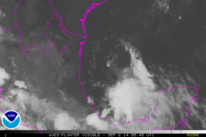
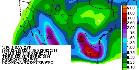
Heavy Rain in Mexico
According
to NOAA's HPC, the 5 day rainfall forecast in northeast Mexico suggests
as much as 4" of rain or more through the upcoming weekend. Some of
this heavy rain will slide into southern Texas
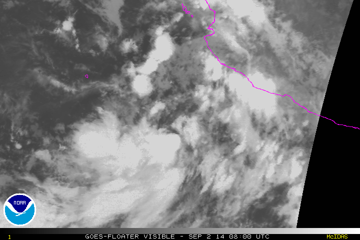
Norbert Develops
Tropical
Storm Norbert developed early Tuesday morning in the Eastern Pacific.
The loop below was sunrise over Norbet just off the west coast of
Mexico.
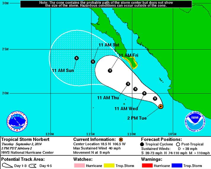
Tracking Norbert
Norbert
is the 14th named storm of the East Pacific Hurricane Season and
follows Hurricane Marie, which was a category 4 hurricane early last
week. According to NOAA's HPC, the forecast keeps Norbert a tropical
storm through the end of the week, however, we could certainly see
hurricane strength at some point this week.
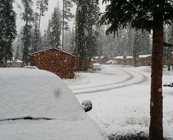
Snowy Labor Day Weekend in the Mountains
While
this may be a shocking view for some, it isn't all that strange to see
snow in the mountains in early September, especially in the peaks. Thanks to the Togwotee Mountain Lodge for the picture below!
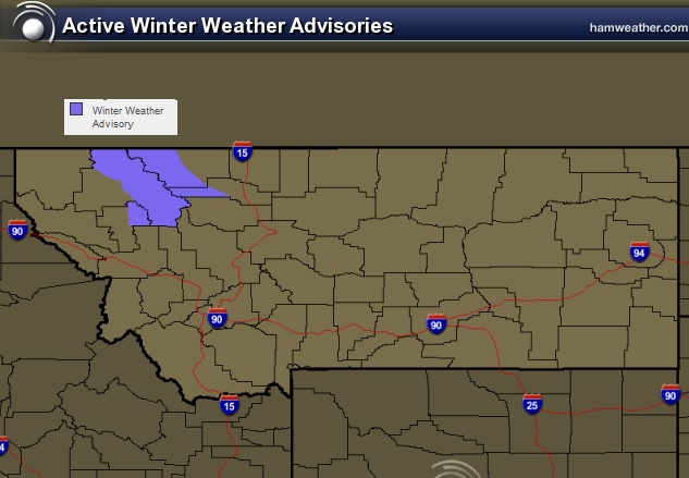
Winter Weather Advisory
...WINTER WEATHER ADVISORY IN EFFECT FROM 3 AM TO 9 PM MDT WEDNESDAY FOR GLACIER NATIONAL PARK WEST OF THE CONTINENTAL DIVIDE...
THE
NATIONAL WEATHER SERVICE IN MISSOULA HAS ISSUED A WINTER WEATHER
ADVISORY FOR SNOW FOR GLACIER NATIONAL PARK WEST OF THE CONTINENTAL
DIVIDE...WHICH IS IN EFFECT FROM 3 AM TO 9 PM MDT WEDNESDAY.
*
IMPACTS: RAIN WILL START THIS EVENING, AND SNOW LEVELS WILL DROP AROUND
6,000 FEET OVERNIGHT CAUSING SNOW ACCUMULATIONS OVERNIGHT AND WEDNESDAY
MORNING. COLD, WET, AND WINDY CONDITIONS WILL BE DANGEROUS FOR THOSE
UNPREPARED IN THE BACK COUNTRY.
*
TIMING: THE HEAVIEST PRECIPITATION IS EXPECTED FROM MIDNIGHT THROUGH 9
AM, WITH THE TRANSITION TO ACCUMULATING SNOW OCCURING AFTER 3 AM MDT.
Weather Outlook
The
same storm responsible for snow in the northern Rockies will be
responsible for some strong to severe storm potential in the Upper
Midwest Wednesday and Thursday.
Baby Gives Thumbs-Up in Womb
LOL!! USA Today has this story about a baby giving a thumbs-up sign durin an ultrasound!!

Thanks for checking in and have a great rest of your week! Don't forget to follow me on Twitter @TNelsonWX

No comments:
Post a Comment