81 F. high in the Twin Cities Friday.
70 F. average high on September 19.
78 F. high on September 19, 2013.
September 19, 2001: 3/4 to 1 3/4 inch hail fell in Freeborn and Faribault counties.
September 19, 1972: Downpour in Duluth, with 5 1/2 inches in ten hours.
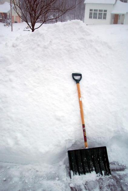
Pulled Punch?
I
just sold my snowmobiles. Part of the reason: My kids are out of the
house and I'm getting old - I don't want to injure myself in a freak
ditch-riding melee. But I'm also starting to wonder if we'll see less
snow than average next winter. Please, let me rationalize my decision.
Confidence
levels are (very) low looking that far out, but Media Logic Group
forensic meteorologist D.J. Kayser made a very interesting discovery:
during
mild El Nino winters,
with a temperature anomaly of .5C warmer than average, MSP snowfall is
nearly half of normal. That means 25 inches versus 55 inches. We still
seem to be limping into a mild to moderate El Nino. We'll see.
Take it with a king-size grain of salt, but every one of
NOAA's long-range climate models,
with acronyms like NMME, IMME and CFS (Climate Forecast System), show
Minnesota and most of North America trending slightly milder than
average from December into February. So the odds of another winter
tracking a stalled polar vortex are small. But not zero.
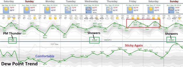
Morning sun gives way to instability showers this afternoon. Sunday looks like the sunnier, drier day with highs in the 60s.
More
showers arrive next Wednesday, otherwise next week looks seasonably
mild and mostly-dry. Models hint at highs near 80F late next week with a
mild bias into early October.
Boating optional.
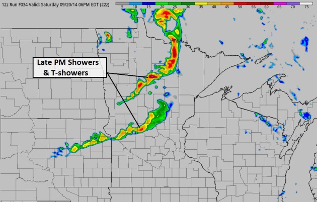
Ripe for Late PM Instability T-Showers.
A few severe storms flared up over far northwestern Minnesota late
Friday, and I wouldn't be surprised to see some strong T-storms later
today as cooler air pushes south, a pocket of cold air aloft setting the
stage for enough instability to support thunder, lightning, even small
hail. Much of the day will be dry with a stiff northwest wind - watch
for showers and possible thunder after 5 PM; earlier up north. 4 KM NAM
solution above: NOAA and HAMweather.
Mild Bias Next 7-10 Days.
Long-range guidance shows a cool-down today into Monday, but
temperatures rebound into the 70s much of next week; another crack at
80F the end of next week. The best chance of showers: Wednesday, again a
week from tomorrow. I see relatively mild weather spilling over into
the first few days of October.
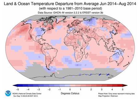
2014 Was a Summer Sizzler: Earth's Hottest on Record. Here's more information on a record-setting summer, worldwide, from
USA TODAY: "
The
planet just had its hottest summer on record, according to data
released Thursday by NOAA's National Climatic Data Center. It's also
well on its way to having its hottest year ever, beating 2010, said
climate scientist Jake Crouch of the data center. The global temperature
for summer was 1.28 degrees above the 20th-century average of 61.5
degrees. Records go back to 1880. Climatologists define summer in the
Northern Hemisphere as the months of June, July and August..."
Map credit above: "
The
parts of the world that were warmer-than-average this past summer are
seen in red and pink on this map, while places that were
cooler-than-average (such as the eastern U.S.) are seen in blue.
" (Photo: NOAA's National Climatic Data Center)
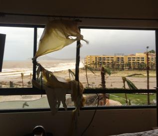
Hurricane Odile: From Paradise to Armageddon in 12 Hours.
Here's a blog account of what really happened in Cabo San Lucas,
Mexico, on the southern tip of Baja, when Category 3 Hurricane Odile
arrived. The impact was even worse than I thought it would be. Here's an
excerpt from a must-read account at
wHaT iT iS: "
I'm
writing from the safety of my family's home in Mexico City after
fleeing Cabo on a rescue plane yesterday morning. Words will never be
enough to portray what I saw and experienced in Cabo during and after
Hurricane Odile, but I want to write the most detailed account so people
can get a sense of what the situation was really like as of Wednesday,
Sept 17- as most media outlets are filtering things likely to protect
tourism in the long run, as well as not to worry friends and relatives
of those in Cabo during the storm. The easiest way to do this is as a
"timeline"...
Family Describes "Nightmare Experience" in Cabo. Q13fox.com has the
harrowing details.
Americans Trapped in Cabo Describe Desperation, Danger. NBC News has the
story.
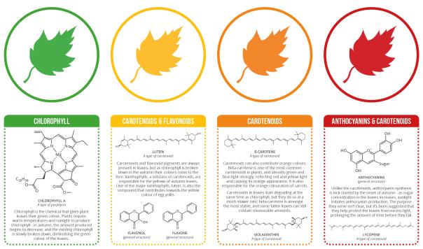
The Chemistry Behind The Different Colors of Autumn Leaves.
Gizmodo and Compound Interest have a good explainer of what makes leaves change colors this time of year; here's an excerpt: "...
Over at Compound Interest,
Andy Brunning has made yet another infographic that gets into the geeky
and fascinating details. Yes, the green of chlorophyll gives way to the
yellow, orange, and red of carotenoids and flavonoids. But that deep
purple and magenta you sometimes see? That's an entirely different class
of compounds, called anthocyanins that plants only start making in the
fall..."
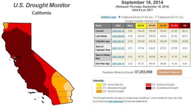
San Diego Nearing 1,000 Days of Drought.
KPBS
has the grim update. Severe El Ninos often bring heavy winter rains to
southern California, but it now appears the developing warm phase of the
Pacific may only be mild to moderate. Here's an excerpt: "...
The last significant rain accumulation in San Diego County occurred in December 2010 when a rare atmospheric river system
brought wave after wave of storms, dumping five inches in downtown,
Tardy said. Record warm temperatures continue to fuel the drought. Tardy
said 2014 has been the hottest year in San Diego County since
temperatures began being recorded 120 years ago. “All things that could
aggravate the drought and make it worse pretty much came into align this
year,” Tardy said..."
* the latest U.S. Drought Monitor is
here.
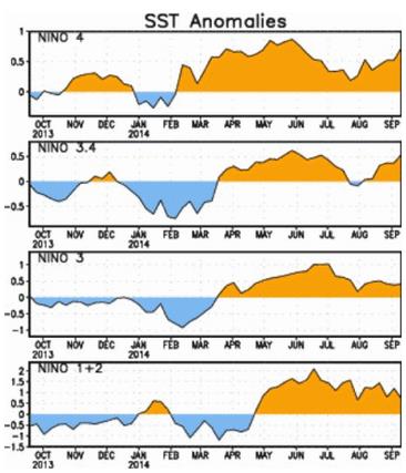
El Nino is Kinda Sorta Maybe Here.
Climate Central takes a look at this year's slow-motion warming phase in the Pacific; here's a clip: "
El Niño watchers, rejoice (maybe). A weak El Niño has formed (sorta). On
Tuesday, researchers at the International Research Institute for
Climate and Society said a borderline El Niño is upon us, with the odds
for further development increasing throughout the fall and winter. This El Niño has played a game of hide and seek
since an El Niño Watch was declared way back in March. After picking up
steam in the spring and early summer, El Niño conditions essentially
disappeared in July and much of August..."
Image credit above: "Chart
showing ocean temperatures in different regions of the Pacific used to
gauge El Niño, including the recent rise in temperatures." Credit: IRI.
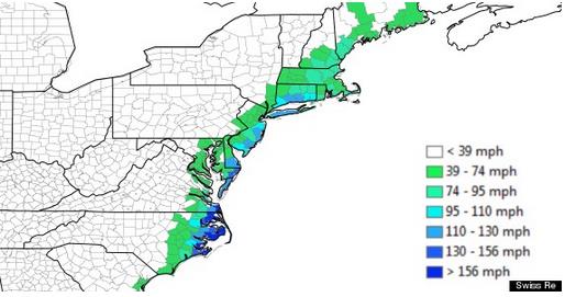
Looking Back to 1821, Insurers Foresee a $100 Billion Hurricane. No, Sandy was not a worst-case scenario for the northeastern USA. Here's an excerpt from an Andrew Revkin Dot Earth story at
The New York Times: "...
The
result is, needless to say, deeply sobering, showing that the losses
from Hurricane Sandy were, as many experts have warned, nowhere near a
worst case. The study’s bottom line? If the 1821 Hurricane were to
happen today, it would cause 50% more damage than Sandy and potentially
cause more than $100 billion in property losses stemming from storm
surge and wind damage..."
Image credit above: "
Analysts at Swiss Re, the giant reinsurance company, have projected that a repeat of the great 1821 hurricane that struck New York City would flood a far greater area than Hurricane Sandy and could cause more than $100 billion in damage." Credit Swiss Re.
Report Warns That Superstorm Sandy Was Not "The Big One". Following up on the Swiss Re report
Huffington Post has more perspective; here's an excerpt: "...
When
the 1821 storm passed through hubs like Washington, D.C. and New York
City, those cities had much smaller populations -- only 136,000 people
combined. Today, Washington alone has more than four times as many
residents, and New York is home to more than 8 million people. Using
meteorological models, geographic and infrastructure data and Swiss Re's
underwriting tools, the report considers the impact an analogous storm
would have today. It predicts a storm surge of up to 12 feet at the
southern tip of Manhattan, and a surge of up to 25 feet in Atlantic
City, New Jersey -- in part because the water is about a foot and a half
higher now than it was in 1821, due to sea level rise..."
What Happens When We All Live To 100? Kiss social security goodbye, right? Here's a snippet of a fascinating article from
The Atlantic: "...
Since
1840, life expectancy at birth has risen about three months with each
passing year. In 1840, life expectancy at birth in Sweden, a
much-studied nation owing to its record-keeping, was 45 years for women;
today it’s 83 years. The United States displays roughly the same trend.
When the 20th century began, life expectancy at birth in America was 47
years; now newborns are expected to live 79 years. If about three
months continue to be added with each passing year, by the middle of
this century, American life expectancy at birth will be 88 years. By the
end of the century, it will be 100 years..."
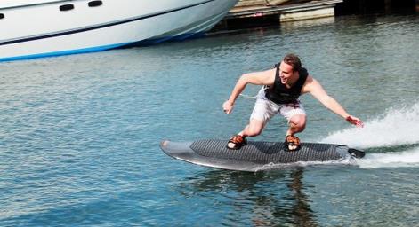
Pushing The Envelope: An Electric Wakeboard?
It's in prototype form, but you can bet that someone will be trying
this out on Minnetonka, Calhoun or Gull Lake in the not-too-distant
future.
Gizmag has details: "
Wakeboarding
sure looks like a lot of fun, but it does have at least one limiting
factor – you need to find someone else to go out on the water with you,
to pilot the boat. Swedish entrepreneurs Alexander Lind and Philip
Werner decided to do something about that, and created the Radinn
electric wakeboard. While it doesn't provide you with a wake on which to
do tricks, it does let you go out when and wherever you want. Currently
in working prototype form, the Radinn has a carbon fiber body, a salt
water-resistant jet propulsion system, and is powered by a lithium
battery pack..."
Dogs Can Be Pessimists Too. I had no idea - but it makes me appreciate my upbeat, perpetually happy spaniel even more; here's an excerpt from
eurekalert.org: "
Dogs
generally seem to be cheerful, happy-go-lucky characters, so you might
expect that most would have an optimistic outlook on life. In fact some
dogs are distinctly more pessimistic than others, research from the
University of Sydney shows. "This research is exciting because it
measures positive and negative emotional states in dogs objectively and
non-invasively. It offers researchers and dog owners an insight into the
outlook of dogs and how that changes," said Dr Melissa Starling, from
the Faculty of Veterinary Science. Her PhD research findings are
published in PLOS today..."
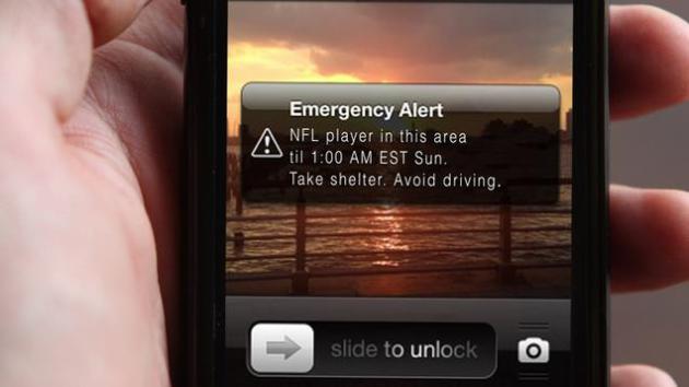
More Cities Using Text-Based Alert System To Warn Americans If They Are In Range of NFL Players. Only
The Onion could pull this off; here's the introduction: "
In
an effort to provide the general public with critical safety
information in a timely manner, sources confirmed Wednesday that an
increasing number of U.S. cities are now using a text-based alert system
to warn Americans who are in the vicinity of an NFL player. “With this
new protocol, residents will be advised via text message to take
shelter, stay off roads, and exercise extreme caution if they are within
close range of any professional football player,” said Baltimore mayor
Stephanie Rawlings-Blake, who praised the new SMS service for delivering
prompt alerts to all cellular devices in a 10-mile radius of any
linebacker, running back, wide receiver, or offensive lineman..."
TODAY: Sunny start, PM showers pop up, possibly a T-storm. Gusty. Winds: NW 15+ High: 74
SATURDAY NIGHT: Evening showers, then slow clearing. Low: 52
SUNDAY: More sun, cool breeze. Winds: NW 15. High: 68
MONDAY: Lot's of sunshine, less wind. Wake-up: 46. High: 69
TUESDAY: Partly sunny, still pleasant. Wake-up: 48. High: 72
WEDNESDAY: Showers likely. Cool & damp. Wake-up: 58. High: 65
THURSDAY: Intervals of sun, turning milder. Wake-up: 59. High: 74
FRIDAY: August rerun. Warm breeze. Wake-up: 62. HIgh: 81
Climate Stories...
New Map of 15 Years of CO2 Emissions.
EarthSky has an interesting story on carbon dioxide emission rates, worldwide. Here's the introduction: "
Researchers
have developed a new system – which they call the Fossil Fuel Data
Assimilation System (FFDAS) – to estimate CO2 emissions from burning
fossil fuels. This new system has now been used to quantify 15 years of
CO2 emissions, every hour, for the entire planet – down to the city
scale. Researchers unveiled the new system in an article published
September 10 in the Journal of Geophysical Research. The FFDAS uses
information from satellite feeds, national fuel accounts and a new
global database on power plants to create high-resolution planetary maps..
Map credit: Gurney Labs.
What A Biblical-Style Flood Could Mean for Washington D.C.
When congressmen have to boat to the U.S. Capitol maybe they'll realize
that something has changed. Here's a clip from a story at
Citylab: "
It's amazing that with a 97 percent scientific consensus on human-caused climate change we still have politicians talking smack
about its importance. Will their tune change at all, one wonders, once
the flood waters are lapping at the base of the federal government? This
mapping tool
can't answer that question, but it does give an indication of what a
climate-enraged flood could mean for Washington, D.C. And to believe the
folks at Climate Central, the independent group that created it with government data, such an epic dousing is nigh. They say the city will "likely
see a record flood before mid-century," meaning one that would measure 8
feet above the high-tide level in the Tidal Basin..."
Global Investors Urge Leaders To Act On Carbon Pricing Ahead of UN Meeting. Here's the intro to a story at
Reuters: "
More
than 340 institutional investors representing $24 trillion in assets on
Thursday called on government leaders attending next week's United
Nations climate summit to set carbon pricing policies that encourage the
private sector to invest in cleaner technologies. Firms signing a joint letter include BlackRock, Calvert Investments, BNP Paribas Investment Partners and Standard Bank..."
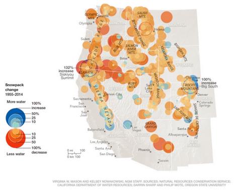
Our Disappearing Snows: Climate Change and Water Resources. We're talking primarily about snow trends over the western USA and Rockies. Peter Gleick has the story at
Huffington Post; here's an excerpt: "...
We're
not ready. We still manage our water systems for the 20th century
climate we use to have, not the 21st century climate we will have. We
still act as though our water problems can be solved with traditional
solutions despite the growing evidence of peak water limits
in places like the western US. And we still assume that we can
indefinitely overdraft our groundwater, suck our rivers dry, and expand
our populations in arid regions. We cannot. The sooner we accept the new
reality of climate change, the sooner we can have a real conversation
about the most effective strategies for truly sustainable water management and use."
Map credit: National Geographic 2014.
http://www.nationalgeographic.com/west-snow-fail/
The Power of Religion and Prayer To Head Off Climate Disaster. Here's an excerpt of an article at
The Guardian: "...
Tutu,
archbishop emeritus of Cape Town and a Nobel peace laureate wrote:
“Through greed, we have established an economy that destroys the web of
life. We have changed our climate and drown in despair. Let oceans of
justice flow. May we learn to sustain and renew the life of our Mother
Earth. We pray for our leaders, custodians of Mother Earth, as they
gather in New York City at the climate talks. May they negotiate with
wisdom and fairness. May they act with compassion and courage, and lead
us in the path of justice for the sake of our children and our
children’s children...”
Photo credit above: "
Archbishop Desmond Tutu has written a prayer asking that leaders act with compassion and courage on climate change."
Photograph: Ian Langsdon/EPA .
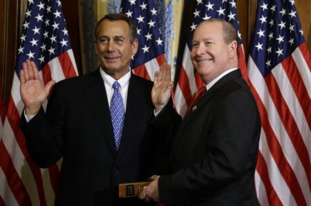
Congressman: "Don't Trust Climate Scientists, They're In It For The Money".
If they were in it for the money they'd be in the private sector,
representing fossil fuel interests, where the big money resides. Here's
an excerpt from
ThinkProgress: "
A very interesting exchange kicked off today’s House Science, Space, and Technology Committee hearing
on the Obama administration’s plan to fight climate change, between
Rep. Larry Bucshon (R-IN) and White House Science Adviser John Holdren.
In it, the Congressman not only sealed himself in the books as a climate
denier, but also admitted that he doesn’t accept the scientific
literature on climate change because the scientists who write it need
global warming to exist in order to get paid..."
Photo credit: "House
Speaker John Boehner, left, performs a mock swearing in for Rep. Larry
Bucshon, R-Ind., Thursday, Jan. 3, 2013, on Capitol Hill in Washington." CREDIT: AP Photo/Charles Dharapak.
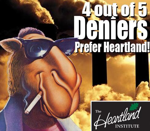
Dems Tie Climate Skeptics to Tobacco, Lead Backers. Here's an excerpt from
TheHill: "
What
the denial apparatus would like is for the public simply to focus on
their stable of well-trained scientists who can come out an offer
counterpoint to the scientists who are honest and trained and know what
they’re talking about and are sincere in what they do,” Whitehouse said
at the Thursday event on Capitol Hill. “When you peel back the curtain
and look at the machinery that produces that, and get a sense that it
has produced it over and over again on different issues, from climate
change to lead paint to tobacco, probably leading all the way back to
putting seatbelts in cars,” he said..."


No comments:
Post a Comment