(Photo Courtesy: Susan Olin via MN DNR)
In Search of Average
By Paul Douglas
Open your mouth and there's a 90 percent probability you'll say something someone disagrees with. Such is the nature of public discourse. John Giudicessi questioned my use of cooling degree days to say summer temperatures were average.
So I asked Pete Boulay at the MN Climate Office for a reality check. "Believe it or not, the summer of 2014 (June-August) finished just slightly above normal in the Twin Cities (mean temperature 71.5 degrees or .2F degrees above normal) Boulay wrote. Daytime highs were slightly cooler, but nighttime lows were significantly milder, a trend we've seen in recent years. Summers are becoming more humid and moist air doesn't cool nearly as fast at night.
A freak early frost across much of Minnesota last Saturday has dredged up paranoia about the winter to come, but I see a mild bias into early October. Expect mid-70s today with a growing chance of thunder; highs brush 80F Saturday before cooling back down Sunday.
The average MSP high now is close to 70F. A building ridge of high pressure warms us well into the 70s next week; another shot at 80F in 1 week. Proving once again that nature never moves in a straight line. There is no such thing as average.
===========================
THURSDAY NIGHT: Clouds increase, not as cool. Slight chance of an isolated shower/storm Low: 57.
FRIDAY: Unsettled, few T-showers expected. Dew point: 64 High: 75. Wind: S 15-25
FRIDAY NIGHT: Spotty showers and storms. Low: 63.
SATURDAY: Partly sunny and mild. PM clouds, a few showers north of MSP. High: 79, falling during the PM hours
SUNDAY: Mix of clouds and sun, cooler. Wake-up: 55. High: 69
MONDAY: Blue sky, hints of October. Wake-up: 46. High: 71
TUESDAY: Warming up to September. Wake-up: 50. High: near 75
WEDNESDAY: Clouds increase, a few showers late. Wake-up: 53. High: 74.
THURSDAY: Humid, showers arrive. Wake-up: 59. High: 69.
===========================
Today in Weather History
September 19th
1998: 1 to 1 3/4 inch hail fell in Meeker, Wright, Todd, and Wilkin Counties winds were also estimated over 50kts.
1980: Golfball to baseball sized hail hit St. Paul. One company had 75 to 95 percent of the glass in their greenhouses smashed.
==========================
Average High/Low for MSP
September 19th
Average High: 70F (Record 94F set in 1895)
Average Low: 51F (Record 33F set in 1991)
==========================
Sunrise/Sunset Times for MSP
Septmeber 19th
Sunrise: 6:56am
Sunset: 7:16pm
==========================
Moon Phase for Friday, September 19th at Midnight
4.2 Days After Last Quarter
============================
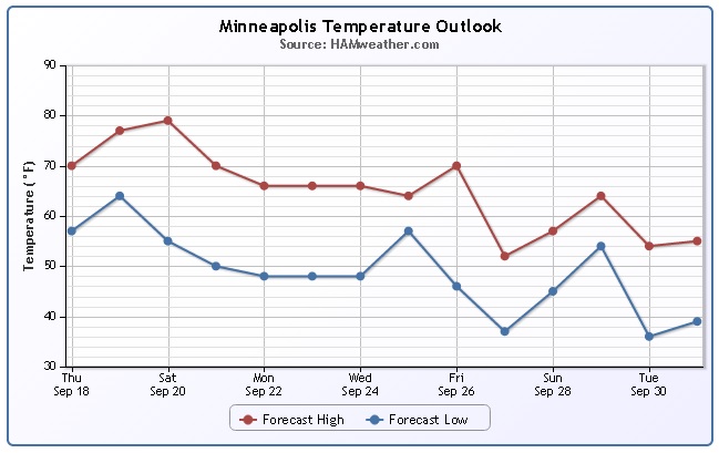
Minneapolis Temperature Trend
A steady decline... probably not what you want to see in the temperature department if you're a fan of summer. Keep in mind that Monday is the Autumnal Equinox (first day of Fall) and September tends to be a month where we see a large drop in our average highs/lows. From the beginning to the end of the month, our average high at MSP goes from 77F to 65F and our average low goes from 65F to 46F. Despite the steady drop in temperatures over the next 15 days, weather conditions as of late have been quite impressive for September, let's hope we can keep that going!
===============================
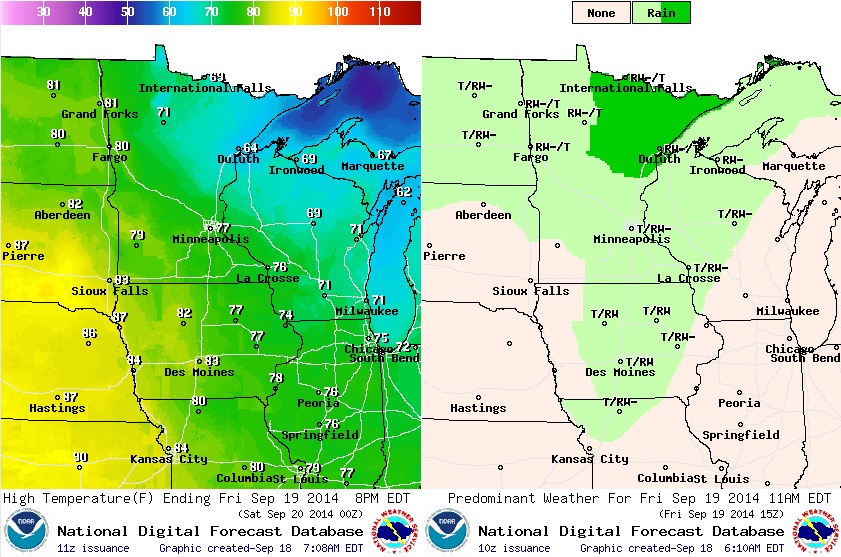
Weather Outlook for Friday
Warmer, but unsettled. An approaching impulse of energy will keep weather conditions a little bit on the unsettled side Friday and Saturday, but we won't have any all day rains. Best chance of heavy rainfall Friday and Saturday appears to be across the northern part of the state. Daytime highs on Friday will range from the 50s & 60s across the northeastern part of the state, while 80F+ will be possible in the western part of the state.
Unsettled Weather Returns
Yes, it appears weather conditions will be a bit on the unsettled side heading into late week/early weekend, but it doesn't look like a washout. The best chance of scattered rain/thunder will be across the northern part of the state PM Friday/AM Saturday. There could be a few lingering showers/storms in central/southern MN AM Saturday, but it looks like we'll start clearing out through the rest of the weekend.
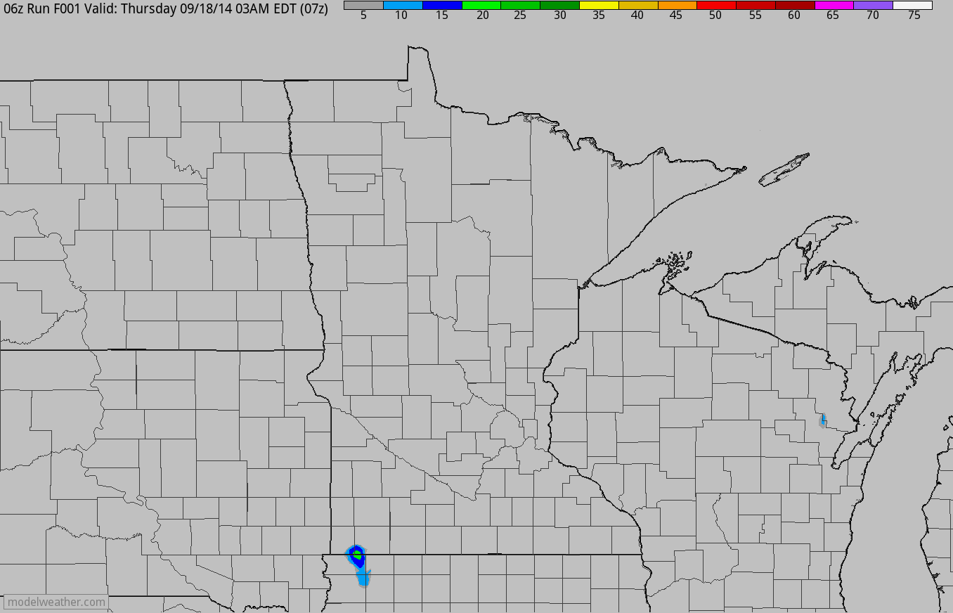
Rainfall Potential
Here's a look at the precipitation potential through Saturday. Again, note that the heaviest and most widespread moisture looks to be positioned across the northern part of the state.
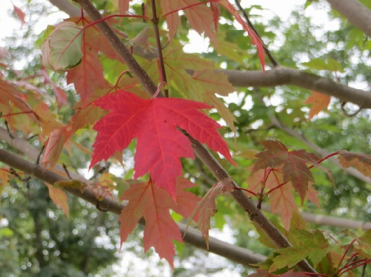
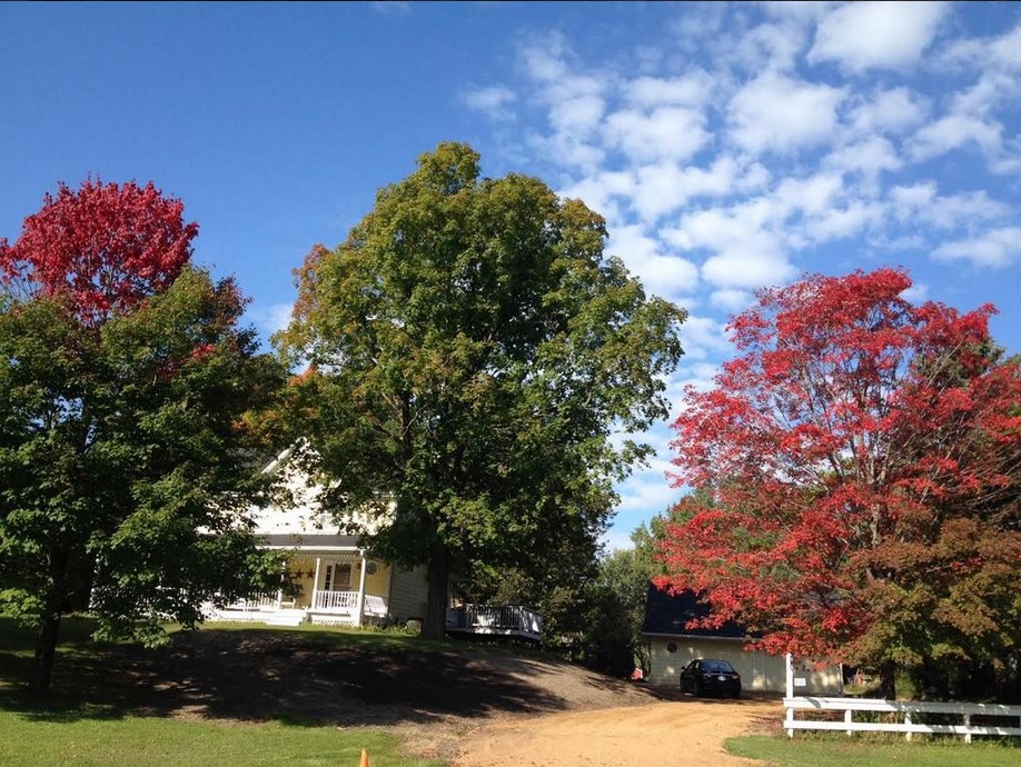
Fall Colors Quickly Turning...
Thanks to my good friend and collegue, Susie Martin for the picture below out of Excelsior, MN where signs of fall are certainly underway. The maples and sumac are sensing a lack of sunlight and cooler weather ahead and have already started turning red.
MN DNR Fall Color Update
According to the MN DNR, parts of the state are already at 25%-50% color in western and northwestern MN. One thing that I've noticed over the years is that the fall color happens quick so don't blink! Unfortunately, we're not too far away from seeing trees without leaves until sometime in the Spring - UGH! The lack of green, to me, is one of the hardest things about living this far north...
See more from the MN DNR HERE:
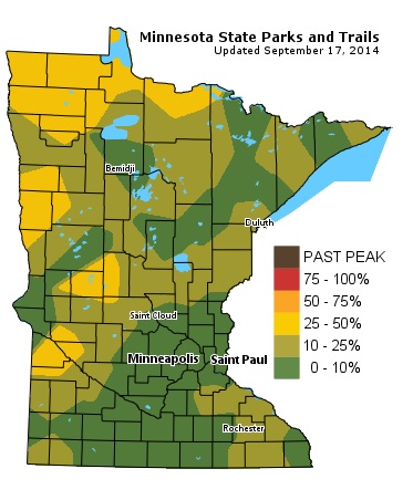
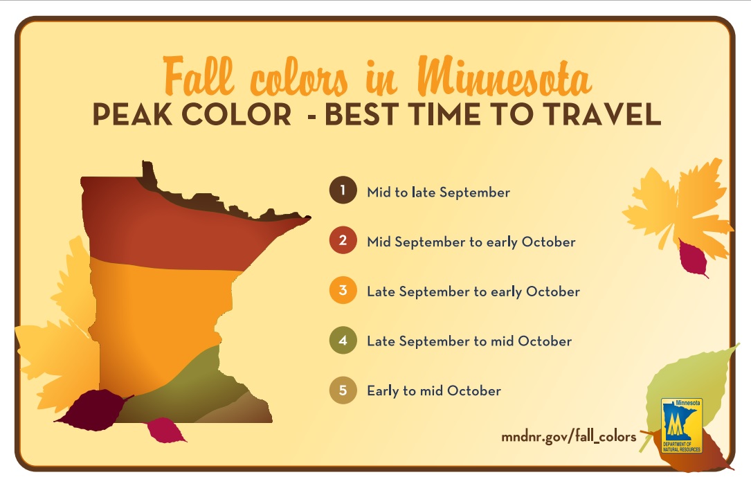
Average Fall Color Peak
Like it or not, we're well underway with fall color across the state. The image below (from MN DNR) suggests the average peak color to help plan your trip to your favorite fall color spot.
My Favorite Fall Color Spots
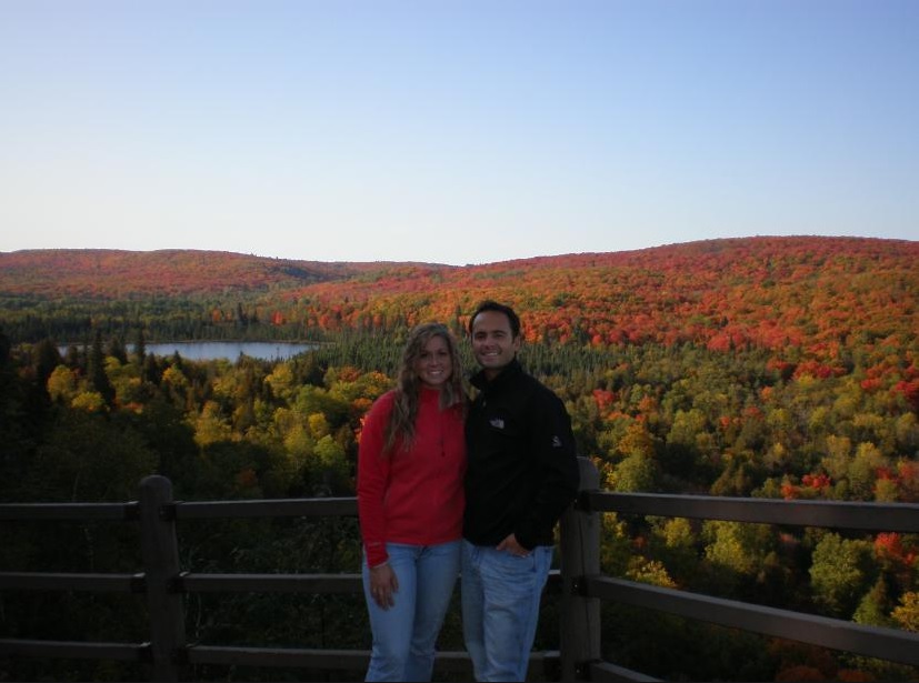
I shouldn't be giving away my favorite fall color spots, but it's hard not share... Minnesota has so many wonderful spots to view fall colors, however if you're planning a trip to the North Shore anytime soon, here are a few of my favorite stops.
1.) Oberg Mountain Loop: On Hwy 61 between Tofte and Lutsen, there is a dirt road called Onion River Rd (FR 336) that takes you to this growing popular spot called Oberg Mountain Loop. It's about 2.25 miles round trip that takes a loop around the top of a mountain, which gives you views of not only Lake Superior, but also the incredible 'inland' colors. The views are breathtaking already, but add peak fall color and you'll be hooked!
2.) Lutsen Mountain: Another one of my favorite spots is at the Lutsen Mountain Ski Area. Not only can you enjoy the Alpine Slide, but take the Mountain Tram to the Summit Chalet ($12.50/rider) and you'll fly through a sea of brilliant colors. At the Summit Chalet, you can have lunch and/or wander around the summit. There's actually a trail and a beautiful overlook on the other side of the summit (short walk), which overlooks more incredible views of the 'inland' maples!
3.) Honeymoon Trail: If you're up for a little drive, take the Honeymoon Trail! The best way I can describe it is imagine a hole cut through the woods with yellow, orange and red colors surrounding you. It's an amazing drive when the colors are peaking...
The picture below was taken a few years ago of my beautiful wife and me at one of the overlooks on the Oberg Mountain Loop during peak color! I WANT TO GO BACK!!!!
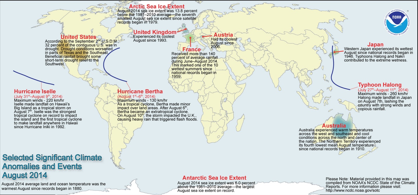
Global Highlights for August 2014
A recent report compiled and released by NOAA shows several global highlights for August.
Read more from NOAA HERE:
** The combined average temperature across global land and ocean surfaces for August 2014 was record high for the month, at 0.75°C (1.35°F) above the 20th century average of 15.6°C (60.1°F), topping the previous record set in 1998.
** The global land surface temperature was 0.99°C (1.78°F) above the 20th century average of 13.8°C (56.9°F), the second highest on record for August, behind 1998.
** For the ocean, the August global sea surface temperature was 0.65°C (1.17°F) above the 20thcentury average of 16.4°C (61.4°F). This record high departure from average not only beats the previous August record set in 2005 by 0.08°C (0.14°F), but also beats the previous all-time record set just two months ago in June 2014 by 0.03°C (0.05°F).
** The combined average global land and ocean surface temperature for the June–August period was also record high for this period, at 0.71°C (1.28°F) above the 20th century average of 16.4°C (61.5°F), beating the previous record set in 1998.
** The June–August worldwide land surface temperature was 0.91°C (1.64°F) above the 20thcentury average, the fifth highest on record for this period. The global ocean surface temperature for the same period was 0.63°C (1.13°F) above the 20th century average, the highest on record for June–August. This beats the previous record set in 2009 by 0.04°C (0.07°F).
** The combined average global land and ocean surface temperature for January–August (year-to-date) was 0.68°C (1.22°F) above the 20th century average of 14.0°C (57.3°F), the third highest for this eight-month period on record.
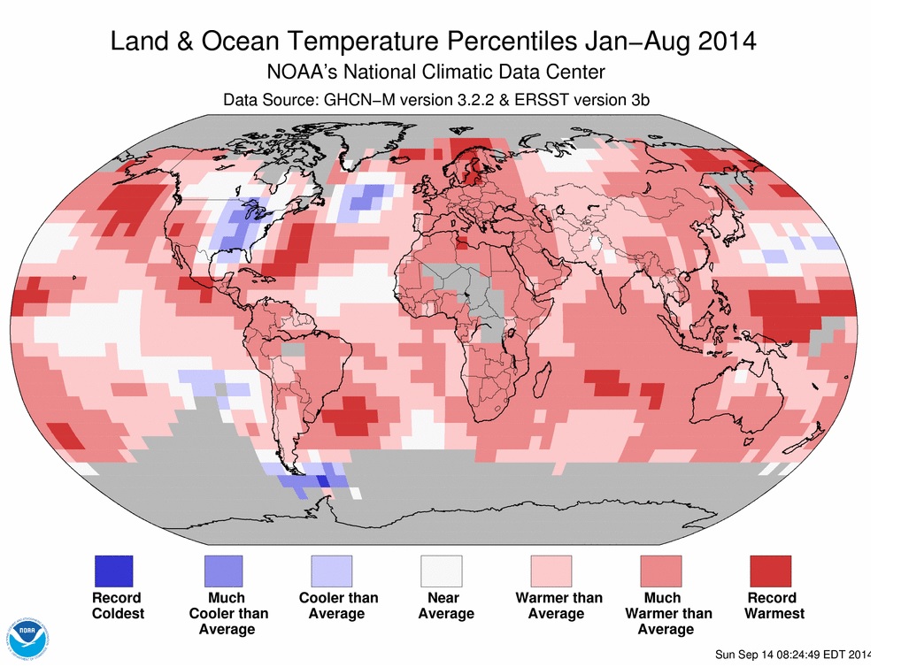
3rd Warmest January - August on Record for Globe
Interestingly,
within that report. NOAA suggests that the January - August period was
the 3rd warmest on record for the globe with sea surface temperatures
tied for the 2nd warmest on record during that same period!
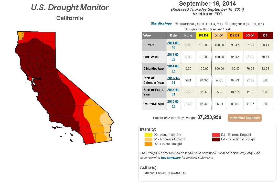
California Drought Continues
According
to the recent U.S. Drought Monitor, Exceptional Drought continues for
nearly 82% of California! 3 Months ago, nearly 77% of the state was
considered to be in an Exceptional Drought, but only 1 year ago only 11%
was in Exceptional Drought. With that said, drought conditions have
been worsening extensively
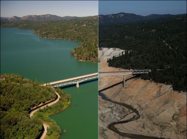
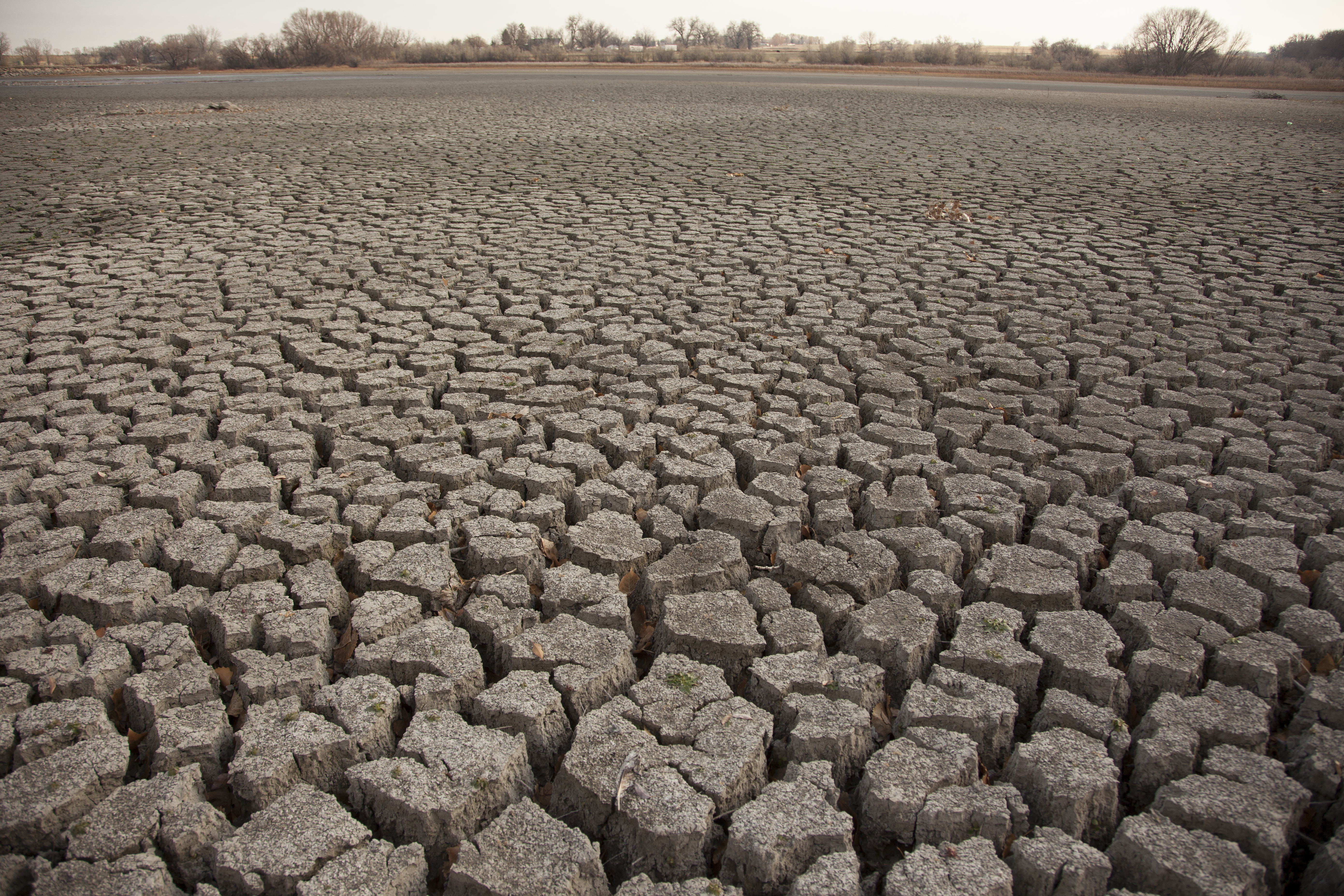
Stunning Before and After Images of California Drought
SFGate.com has compiled several before and after photos of the drought, which are pretty amazing.
New California Law to Limit Groundwater Pumping for First Time
Here's an interesting story from NationalGeographic.com about a new law that was signed on Tuesday to limit groundwater pumping.
"Despite California's reputation as an environmental policy leader, its regulation of groundwater extraction has long been among the weakest in the nation. That changed Tuesday, when California Governor Jerry Brown signed a package of three bills designed to regulate the pumping of water from underground aquifers.
While many observers say the rules are too little and too late to protect the state's rapidly depleting aquifers, the new laws are still a major shift in a long-deadlocked political battle.
"They don't solve all our problems, but they're a critical step in the right direction," says Jay Famiglietti, a hydrologist at the University of California, Irvine."
Read more HERE:
Thanks for checking in and have a great rest of your week/weekend ahead!

No comments:
Post a Comment