59 F. high in the Twin Cities Tuesday.
65 F. average high on September 30.
80 F. high on September 30, 2013.
September 30 in Minnesota Weather History. Source: MPX National Weather Service:
1999:
One of the earliest significant snowfalls fell in a narrow track across
southern Minnesota. Reported snowfall totals included 4.0 inches in
Montgomery (LeSeur County) and Northfield (Rice County), 3.8 inches in
Springfield (Brown County), 3.0 inches in Vesta (Redwood county), and
2.8 inches in Mankato (Blue Earth County).
1989:
Temperatures across central and southern Minnesota were in the 80's. A
cold front came through and dropped the mercury to the 40's.
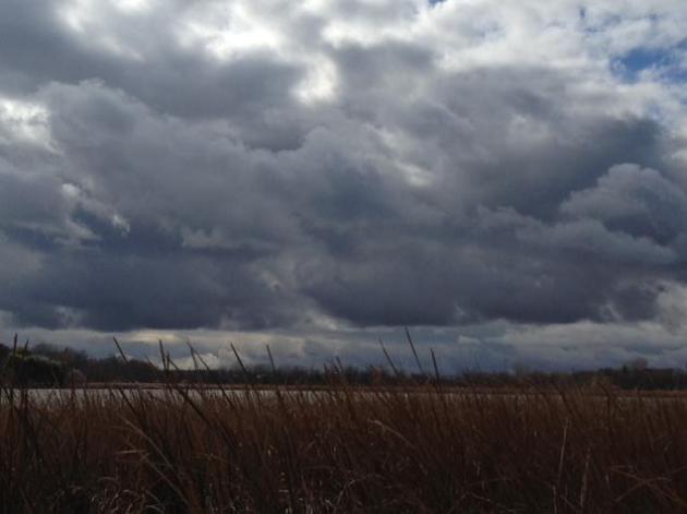
Risk of October
Summer
is a fading memory, a buggy, thundery mirage on the distant horizon.
The sun is slipping ever lower into the southern sky now; longer nights
chilling the Canadian prairie, sparking a parade of increasingly cold
puffs. Nature's way of saying "do I have your attention yet?"
October
is a fiendishly fickle month, capable of 90-degree heat, isolated
tornadoes and Halloween Superstorms. The first frost in the metro
usually arrives the first week of October - first flakes by mid-October;
average snowfall for the month about a half inch or so.
Large
north-south temperature contrasts whip up powerful storms. Unlike summer
when precipitation is "convective" (thunderstorms 3-5 miles wide)
smears of "stratiform" rain in October produce widespread puddles. Less
hit or miss. By the end of the month the average high is a crisp 51F,
give or take 20 degrees.
Today is the wettest day of the week; up
to an inch of rain turning I-35 into a perpetual parking lot. Another
surge of rain comes Thursday. Cold exhaust behind this storm has us
groping for jackets by Friday, when temperatures hold near 50F with
flurries over the Arrowhead.
60s return next week; I suspect we'll see a few more 70s before winter does its thing.
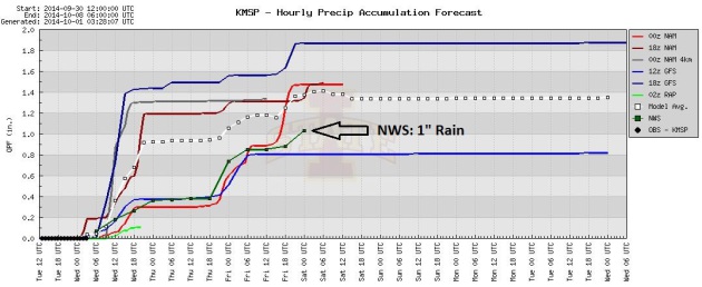
Potentially Significant Rain Next 36-48 Hours.
Models show anywhere from .8" to 1.8" of rain by Thursday night as
colder air approaches. The National Weather Service official prediction
is roughly 1" of rain by Friday morning.
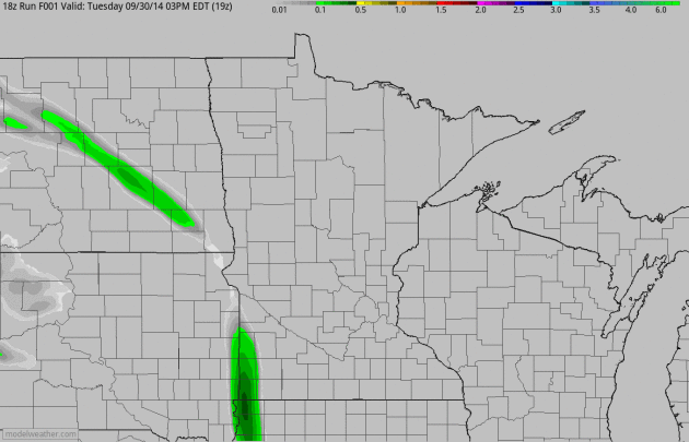
Narrow Band of Moderate to Heavy Rain.
NOAA's 4 km NAM model shows some 2.5"+ amounts just east of the St.
Croix River by Friday morning; heaviest amounts over the southern and
eastern suburbs, but many towns in the MSP metro area should pick up at
least 1" of rain from two separate surges of rain, spiked with a few
T-storms. 60-hour accumulated rainfall: HAMweather.
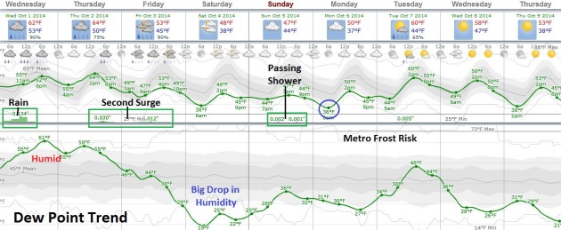
Cooling
Down. Enjoy low 60s today and Thursday because Friday and Saturday may
feel more like early November than early October with temperatures
holding in the 40s, and a definite whiff of wind chill. Heaviest rains
come today and Thursday; the approach of milder air setting off a few
spotty showers on Sunday. The best chance of a metro-wide frost: Monday
morning. Source: Weatherspark.
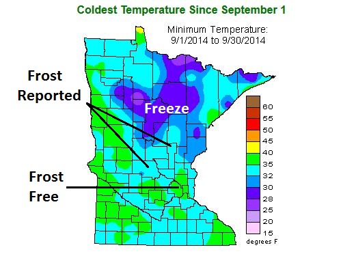
MSP Metro Still Largely Frost-Free. Data from the
Minnesota Climatology Working Group
shows that much of Minnesota has already experienced a frost or freeze,
with the exception of the immediate Twin Cities metro area, where the
urban heat island has kept temperatures above 32F so far. The growing
season may finally end within the 494/694 freeway system by Monday
morning.
Weather Report: Forecasts Improving As Climate Gets Wilder. Here are a few interesting nuggets, courtesy of
The BBC: "...
The
UK's Met Office says its four-day forecast is now as accurate as its
one-day forecast was 30 years ago. And Louis Uccellini, director of the
National Weather Service, part of the US government's National Oceanic
and Atmospheric Administration, says: "We can now predict extreme
weather events five to seven days in advance. "Twenty years ago we would
only have been able to look one day ahead." These improvements have
only come about after investing billions in better satellites, weather
stations and supercomputers..."
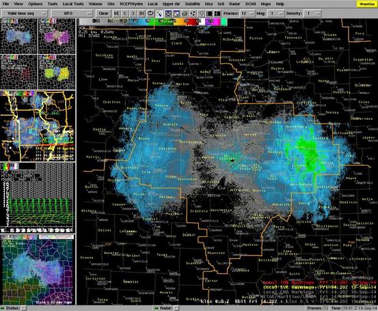
Mystery Solved. Suspicious Radar Echoes Were Probably Migrating Monarch Butterflies. The Washington Post's
Capital Weather Gang takes a look at what was producing those strange Doppler returns on a perfectly clear day in St. Louis; here's an excerpt: "...
From
the radar echoes, it might seem as if there was quite a swarm of
butterflies heading south on Friday. However, it doesn’t take much for
the radar to light up when it’s dry out. “In dry conditions, the radar
is very sensitive to something like insects,” said Kanofsky. “It doesn’t
take a whole lot of insects to create a high return.” As a
meteorologist, you don’t picture yourself spending time digging for
information on migrating bugs on the internet, trying to figure out why
the radar is glowing when there’s not a cloud in the sky..."
Image credit above: "
A
screenshot taken by NWS meteorologists, capturing the odd radar
reflectivity that appeared east of St. Louis, Mo. on Friday morning." (
NWS St. Louis via Facebook)
Earth Lost 50% Of It's Wildlife In The Past 40 Years, Says WWF. Some grim news from the World Wildlife Federation - here's an excerpt from
The Guardian: "
The
number of wild animals on Earth has halved in the past 40 years,
according to a new analysis. Creatures across land, rivers and the seas
are being decimated as humans kill them for food in unsustainable
numbers, while polluting or destroying their habitats, the research by
scientists at WWF and the Zoological Society of London found. “If half
the animals died in London zoo next week it would be front page news,”
said Professor Ken Norris, ZSL’s director of science. “But that is
happening in the great outdoors. This damage is not inevitable but a
consequence of the way we choose to live.” He said nature, which
provides food and clean water and air, was essential for human wellbeing..."
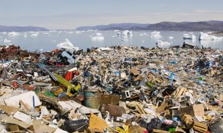
Photo credit above: "
Rubbish
dumped on the tundra outside llulissat in Greenland stand in stark
contrast to icebergs behind from the Sermeq Kujullaq or llulissat Ice
fjord – a Unesco world heritage site."
Photograph: Global Warming Images/WWF-Canon.
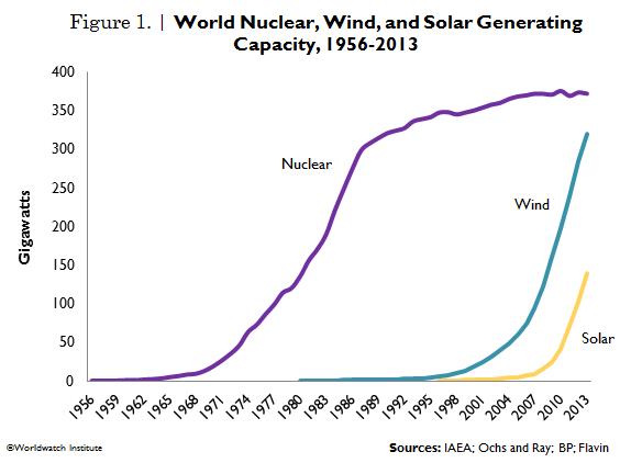
Wind, Solar Generation Capacity Catching Up With Nuclear Power. Here's an excerpt of an interesting (and encouraging) article at Vital Signs Online, courtesy of
The Worldwatch Institute: "
Nuclear’s
share of global power production has declined steadily from a peak of
17.6 percent in 1996 to 10.8 percent in 2013. Renewables increased their
share from 18.7 percent in 2000 to 22.7 percent in 2012. Hydropower
was the leading source of renewable electricity (16.5 percent of global
power in 2012), while wind contributed 3.4 percent and solar, 0.6
percent. But wind and solar energy are the fastest growing electricity
technologies worldwide. Between 2000 and 2012, wind power grew nearly
16-fold and solar jumped 49-fold..."
Why Do So Many People Watch HGTV? I admit I'm a "Love it or List it" addict. It's like Jeopardy for homeowners.
Pacific Standard Magazine looks at the formula that keeps many of us coming back for more; here's an excerpt: "...
A few months ago, Jen Doll wrote about the tireless appeal of House Hunters
in particular. For Doll, the show is all about the “underlying theme of
unbridled domestic aspiration paired with the reality of compromise,
the appearance versus the actuality of what we want and what we can
have.” Much of the network’s marquee programming beyond House Hunters is
about trading up, re-investment, buying, and selling. HGTV, as we might
expect, is so watchable because it features attainably realistic ritual
re-enactments of the American Dream every half-hour..."
New Coffee Drip System Takes 4 Hours To Brew The Perfect Cup. I love my coffee, but I'm not sure I'd have the patience. Here's an excerpt from
Gizmag: "...
The
Imperial Proper Coffee Drip uses a peristaltic pump to draw the water
out of the brewing vessel and through the ground coffee one drip at a
time. The speed of the pump can be adjusted for a lighter brew to be
produced in an hour or for a stronger cup of joe in up to four hours.
Proper Coffee recommends a speed of 40 to 45 drips per minute, which
will result in a strong flavorsome beverage.."
TODAY: Rain, heavy at times. A few T-storms. Winds: SE 10. High: 63
WEDNESDAY NIGHT: More showers, possible thunder. Low: 56
THURSDAY: Another surge of rain likely. High: 61
FRIDAY: Cold and raw. Lingering showers, especially PM hours. Wake-up: 46. High: 51
SATURDAY: Mostly cloudy, jacket-worthy. Wake-up: 37. High: 49
SUNDAY: Lot's of clouds, still chilly. Wake-up: 44. High: 48
MONDAY: Metro frost. Plenty of sun. Wake-up: 36. High: 51
TUESDAY: Early shower, then slightly milder with some PM sun. Wake-up: 44. High: near 60
Climate Stories...
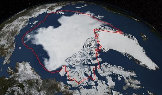
Thinner Too, Arctic Sea Ice Minimum Sixth Lowest on Record. Science 2.0 has an update on what's happening at the top of the world; here's a clip: "
Arctic
sea ice coverage declined to its annual minimum on September 17th and
the National Snow and Ice Data Center (NSIDC) at the University of
Colorado, Boulder find that this year's minimum extent is similar to
last year's and below the 1981-2010 average of 2.40 million square
miles. Over the 2014 summer, Arctic sea ice melted back from its maximum
extent reached in March to a coverage area of 1.94 million square
miles, according to analysis from NASA and NSIDC scientists..."
Image credit above: "
Arctic
sea ice hit its annual minimum on Sept. 17, 2014. The red line in this
image shows the 1981-2010 average minimum extent. Data provided by the
Japan Aerospace Exploration Agency GCOM-W1 satellite." Image: NASA/Goddard Scientific Visualization Studio.
 How Global Warming Affected Extreme Weather Events in 2013 - Interactive
. Following up on yesterday's posts here's an effective interactive infographic from
The Guardian: "
From
Australia’s off-the-charts heat wave to Colorado’s biblical deluge,
Europe’s scorching summer, and Britain’s miserable spring, nine events
were caused at least in part by climate change, scientists conclude in a report
in the Bulletin of the American Meteorological Society on Monday.
Overseen by the US Noaa and the UK Met Office, 92 scientists from 14
countries looked at how climate change affected 16 of the biggest
weather events of 2013."
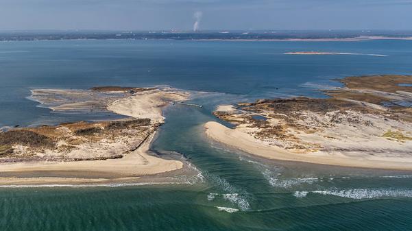
Growing, And Growing Vulnerable. Barrier islands are at special risk from warming/rising seas. Here's a clip from a story at
The New York Times: "...
But the barrier islands that line the Atlantic and Gulf Coasts, from Cape Cod to the Mexican border, are a special case. A new report from the National Research Council
finds that the effect of climate change is especially harsh on these
islands. Population growth in much of this long coast “is nearly twice
the national average,” the report said. Meanwhile, “these same coasts
are subject to impact by some of the most powerful storms on earth and
the destruction potential of these events is increasing due to climate
change and relative sea-level rise...”
Photo credit above: "An aerial view of a breach in the Fire Island National Seashore caused by Hurricane Sandy." Credit National Park Service.
Lyme Disease Surges North, And Canada Moves Out of Denial. The Daily Climate has the latest on trends north of the border; here's an excerpt: "...Canada
should have seen this coming. In the United States, reported cases of
Lyme disease have increased from fewer than 10,000 reported cases in
1991 to more than 27,000 cases by 2013. Canada was well-positioned to be
affected by the spread of the disease. As early as 2005, modeling published
by researcher Nicholas Ogden, then at the University of Montreal,
indicated that the geographic range of the Lyme-carrying tick could
expand northward significantly due to climate change in this century..."
Despite The U.N. Climate Summit, Fossil Fuel Firms Are Still In For The Long Term.
Trillions of dollars at stake, climate change represents a potential
existential crisis for companies that rely on future reserves of coal,
oil and gas to be brought to market, as reported by
The Guardian. Here's a snippet: "...
Fossil fuel companies are still in it for the long term. As the Financial Times and Guardian has reported, this year ExxonMobil and Shell
both wrote to investors to say that their fossil fuel businesses would
stay strong for decades, even if governments take action on climate
change. Investing in fossil fuels not only perpetuates existing
high-carbon infrastructure, but it uses up money and attention that
could have been directed to low-carbon ends..."
Photo credit above: "
U.S. president Barack Obama at the UN climate summit in New York." Photograph: Mark Garten//UN Photo/Sipa/SI/Rex.
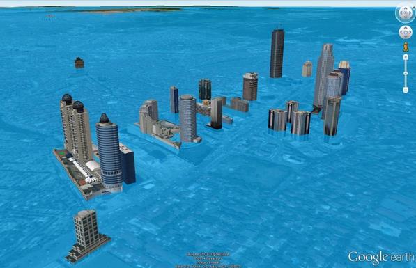
Will Global Warming Drown Your Hometown?
Not something we have to worry about anytime soon here in Minnesota,
but for coastal residents worldwide it's a more urgent calculation.
Here's an excerpt from a blog at
Scientific American: "...
In
this week’s Map Monday, I’d like to share a new mapping technology
which helps answer the question: will global warming drown your
hometown? Actually, it’s not a new technology, it’s a “repurposed”
technology if you will, namely Lidar, or Light Detection and Ranging,
which gives you detail on elevation mapping by location. Have a look at Surging Seas and #DrownYourTown. It makes for scary gamification of climate change, but perhaps it’s a needed wake-up call for some?..."
Image credit above: "
Istanbul after GIS modeling of climate change." Image courtesy of #DrownYourTown.
The Climate Denier's Newest Argument. Here's a clip from an Op-Ed by Jeffrey Kluger at Time Magazine: "...Koonin
then ticks off the usual right-wing talking points: The computer models
are imperfect; the oceans’ role in warming has not been studied fully;
the history of Earth’s climate is poorly understood; there has been a
slowing of warming over the past 15 years. Stipulated, stipulated,
stipulated and stipulated. Again and again, climate scientists
acknowledge every single one of these x-factors and again and again they
come back to the fact that the planet is sick and we’re playing a role.
Knowing that cigarettes can kill you is not the same as pretending to
predict which fatal illness—if any—you’re going to contract or just when
and how severely that disease is going to strike. But you can surely
tell when you’re beginning to cough, and if you don’t quit smoking
straightaway you’re a fool..."


No comments:
Post a Comment