57 F. high in the Twin Cities Wednesday.
65 F. average high on October 1.
77 F. high on October 1, 2013.
.69" rain fell at MSP International Airport yesterday.
October 1, 1953:
A record high of 90 degrees Fahrenheit for the St. Cloud area was
recorded in 1953 (and later tied in 1992). Minneapolis also set a record
that same day in 1953 with a high of 89 degrees.
October 1, 1849: Persistent rain at Ft. Snelling leaves 4 inches in a day-and-a half.
Sloppy Miracle
The
Talmud says "We do not see things as they are. We see them as we are."
Someone once told me there are only two ways to live your life. One is
as though nothing is a miracle. The other is as though everything is a
miracle.
You may have serious doubts about alleged miracles as you
slog home from work later today. Rain annoys commuters but look at the
bright side: Minnesota is now drought-free. And this early October
soaking is recharging soil moisture after a late summer dry spell,
setting the stage for more agricultural miracles in 2015. And it's not
snowing.
If anyone asks, last year the first flurries came October
19; the first inch of slush November 5-6. Pretty close to average, yet
winter was anything but average. Let's take it one day at a time.
A
second surge of rain clips the metro later today and tonight; more
windblown showers tomorrow as a taste of early November arrives. Daytime
highs hold near 50F tomorrow into Monday, before 60s return the middle
of next week. Flurries are possible up north by tomorrow night; a metro
frost can't be ruled out Sunday morning.
In defense of this wet, gloomy spell gray, soggy days are good for business.
Fewer distractions. Less time staring out the window.
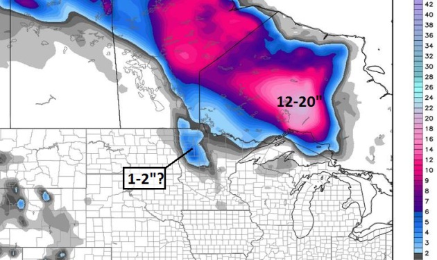
Early Snow Red River Valley?
Model guidance is hinting at an inch or two of slush Friday night near
Bemidji and Hallock, although warm ground temperatures may trigger
melting on contact. A coating of slush up north by Saturday morning?
Very possible, and a few stray flakes may reach the MSP metro area late
Friday night. North of Lake Superior over a foot of snow may fall as a
cut-off low lingers, drawing in enough cold air for what may turn out to
be a very significant snowfall. Insert gasp here. Map: Weatherbell.
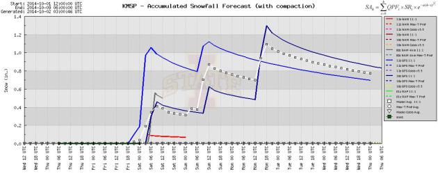
More Early November Than Early October.
A few models are hinting at a little wet snow reaching the Twin Cities
by Friday night and early Saturday. Even if you spy a few flakes outside
your window relatively mild ground temperatures should prevent anything
from sticking.
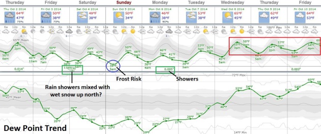
An Early November - October Returns Next Week.
Daytime highs may not climb out of the 40s Friday into Monday; if skies
clear and winds ease frost may settle over many suburbs Sunday morning.
Milder Pacific air returns next week with a good chance of highs
topping 60F by midweek. Source: Weatherspark.
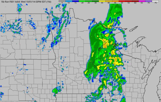
First Whiff of Winter.
The leading edge of cooler air pushes a band of heavy rain from Kansas
City into Chicago and Milwaukee today; a colder, second surge of
Canadian air sweeping across the Dakotas into the Upper Mississippi
Valley on Friday. 60-hour accumulated 4 km NAM rainfall product: NOAA
and HAMweather.
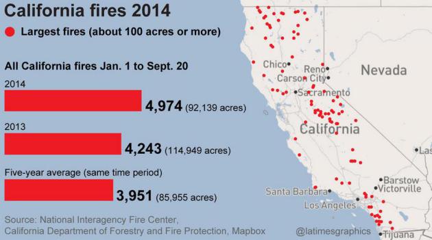
California Has Already Burned Through $209 Million Wildfire Budget, and SoCal's Fire Season Has Just Begun. Here are a few excepts of a story at
The Los Angeles Times: "
California
has burned through its wildfire-fighting budget -- $209 million -- just
as it faces what is historically the worst of the fire season. And the
state already has tapped into its reserves, pulling out $70 million more
to combat drought-fueled blazes...Some of the costs of fighting state
wildfires will be reimbursed by the federal government. But those funds
are running low. Wildfires cost the U.S. about $125 billion annually.
Earlier this month, state officials requested that Congress set up an emergency reserve, like California's, to help pay for extreme fires..."
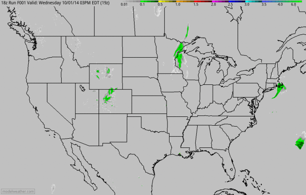
Weather Service Storm Forecasts Get More Localized.
I've been showing you examples of NOAA's new HRRR (3 km) model, but
earlier this week they made it official, going from beta to a more
general release. Here's an excerpt of a story from AP and
8 News NOW: "
The
next time some nasty storms are heading your way, the National Weather
Service says it will have a better forecast of just how close they could
come to you. The weather service on Tuesday started using a new high
resolution computer model that officials say will dramatically improve
forecasts for storms up to 15 hours in advance. It should better
pinpoint where and when tornadoes, thunderstorms and blizzards are
expected, so people could take cover..." (HRRR model guidance above: NOAA and HAMweather.)
Weather Report: Forecasts Improving As Climate Gets Wilder. Here are a few interesting nuggets, courtesy of
The BBC: "...
The
UK's Met Office says its four-day forecast is now as accurate as its
one-day forecast was 30 years ago. And Louis Uccellini, director of the
National Weather Service, part of the US government's National Oceanic
and Atmospheric Administration, says: "We can now predict extreme
weather events five to seven days in advance. "Twenty years ago we would
only have been able to look one day ahead." These improvements have
only come about after investing billions in better satellites, weather
stations and supercomputers..."
Earth Lost 50% Of It's Wildlife In The Past 40 Years, Says WWF. Some grim news from the World Wildlife Federation - here's an excerpt from
The Guardian: "
The
number of wild animals on Earth has halved in the past 40 years,
according to a new analysis. Creatures across land, rivers and the seas
are being decimated as humans kill them for food in unsustainable
numbers, while polluting or destroying their habitats, the research by
scientists at WWF and the Zoological Society of London found. “If half
the animals died in London zoo next week it would be front page news,”
said Professor Ken Norris, ZSL’s director of science. “But that is
happening in the great outdoors. This damage is not inevitable but a
consequence of the way we choose to live.” He said nature, which
provides food and clean water and air, was essential for human wellbeing..."
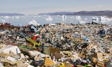
Photo credit above: "
Rubbish
dumped on the tundra outside llulissat in Greenland stand in stark
contrast to icebergs behind from the Sermeq Kujullaq or llulissat Ice
fjord – a Unesco world heritage site."
Photograph: Global Warming Images/WWF-Canon.
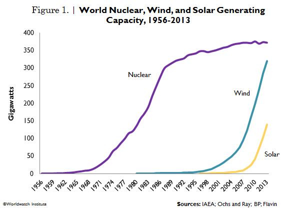
Wind, Solar Generation Capacity Catching Up With Nuclear Power. Here's an excerpt of an interesting (and encouraging) article at Vital Signs Online, courtesy of
The Worldwatch Institute: "
Nuclear’s
share of global power production has declined steadily from a peak of
17.6 percent in 1996 to 10.8 percent in 2013. Renewables increased their
share from 18.7 percent in 2000 to 22.7 percent in 2012. Hydropower
was the leading source of renewable electricity (16.5 percent of global
power in 2012), while wind contributed 3.4 percent and solar, 0.6
percent. But wind and solar energy are the fastest growing electricity
technologies worldwide. Between 2000 and 2012, wind power grew nearly
16-fold and solar jumped 49-fold..."
FCC Considering Move To Ban Washington Redskins Name.
Interesting times for the NFL and many team owners. I vote for
Washington Lobbyists. Has a nice ring. Here's an excerpt from Reuters
and
Huffington Post: "
The
Federal Communications Commission is considering whether to punish
broadcasters for using the moniker of the Washington NFL team, the
Redskins, a word many consider a slur to Native Americans, the agency's
chairman indicated on Tuesday. The FCC, which enforces broadcast
indecency violations, has received a petition from legal activist John
Banzhaf III, asking that regulators strip local radio station WWXX-FM of
its broadcasting license when it comes up for renewal for using the
name "Redskins..."
Caffeine-Infused Underwear Probably Doesn't Help You Lose Weight. That may come as a shock to some of you, but this story excerpt from
Reuters explains in more detail: "
Bras,
girdles and leggings infused with caffeine and sold as weight loss aids
were more decaf than espresso, and the companies that sold them have
agreed to refund money to customers and pull their ads, U.S. regulators
said on Monday. The Federal
Trade Commission said Wacoal America and Norm Thompson Outfitters, which
owns Sahalie and others, were accused of deceptive advertising that
claimed their caffeine-impregnated clothing would cause the wearer to
lose weight and have less cellulite..."
TODAY: Gray, more showers later in the day. Winds: NW 5-10. High: 61
THURSDAY NIGHT: A period of rain tapering late. Low: 45
FRIDAY: Colder wind, passing PM showers. Heavy jackets/blankets for evening football games. High: 50
SATURDAY: Fine November day. Mostly cloudy and brisk. Wake-up: 38. High: 49
SUNDAY: Metro frost possible. Dry, chilly Twin Cities Marathon with intervals of sun. Wake-up: 34. High: 50
MONDAY: Mostly gray, still raw for early October. Wake-up: 37. High: 48
TUESDAY: Intervals of sun, a bit better. Wake-up: 36. High: 54
WEDNESDAY: Milder, few PM showers up north. Wake-up: 45. High: 64
Climate Stories...
How Will Climate Change Affect Fall Foliage? Modern Farmer takes a look at how shifting seasons are impacting the timing and intensity of peak fall color; here's the introduction: "
Researchers at Princeton University recently took a deep dive
into the lovely autumnal colors of the Northeast and Midwest with an
eye on climate change. They found that as the planet heats up, fall
foliage will respond in messy, unpredictable ways — and that as a whole,
leaves will begin changing color later and the period in which bright
orange, red and yellow leaves stay on trees will last longer. But even
though tourists in Vermont may celebrate, it’s important to note that
the researchers’ findings indicate changes that could extend beyond fall
photo ops. Trees, as it turns out, are the canary in the coal mine..."
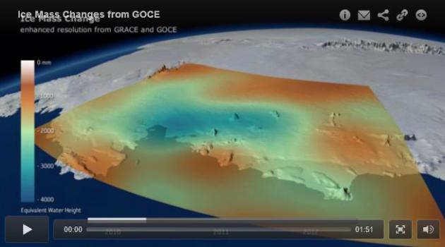
Antarctica Has Lost Enough Ice To Cause A Measurable Shift in Gravity. Here's a clip from a story at Slate and
WIRED: "...
The
biggest implication is the new measurements confirm global warming is
changing the Antarctic in fundamental ways. Earlier this year, a separate team of scientists announced
that major West Antarctic glaciers have begun an “unstoppable”
“collapse,” committing global sea levels to a rise of several meters
over the next few hundred years. Though we all learned in high-school
physics that gravity is a constant, it actually varies slightly
depending on where you are on the Earth’s surface and the density of the
rock (or, in this case, ice) beneath your feet..."
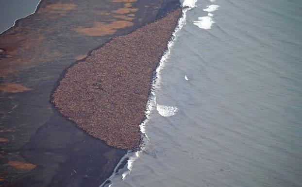
This One Photo Perfectly Sums Up Why Climate Change is Real.
Buzzfeed has the story and explanation; here's an excerpt: "...
It's
another remarkable sign of the dramatic environmental conditions
changing as the result of sea ice loss," said World Wildlife Fund Arctic
program director Margaret Williams. “The walruses are telling us what
the polar bears have told us and what many indigenous people have told
us in the high Arctic, and that is that the Arctic environment is
changing extremely rapidly and it is time for the rest of the world to
take notice and also to take action to address the root causes of
climate change...”
Image credit above: AP Photo/NOAA, Corey Accardo.
Japanese Scientists Think Climate Change Could Alter Human Male-to-Female Birth Ratio. How on Earth could there be a link with extreme weather events? Here's an excerpt from
The Mary Sue: "...
After
lining up monthly temperature data from the Japan Meteorological agency
and fetal death data from the Vital Statistics of Japan database,
Fukuda and a team of researchers believe that there is an association
(though not causation that they can successfully pin down, of course)
between extreme weather fluctuations and a decrease in male babies. They
note in their findings, which were published this month in Fertility and Sterility journal,
that two very intense seasonal shifts caught their attention in
particular; a very hot summer in 2010 and a very cold winter in 2011,
both of which correlate to an increase in fetal deaths and an eventual
decrease in male babies being born..."
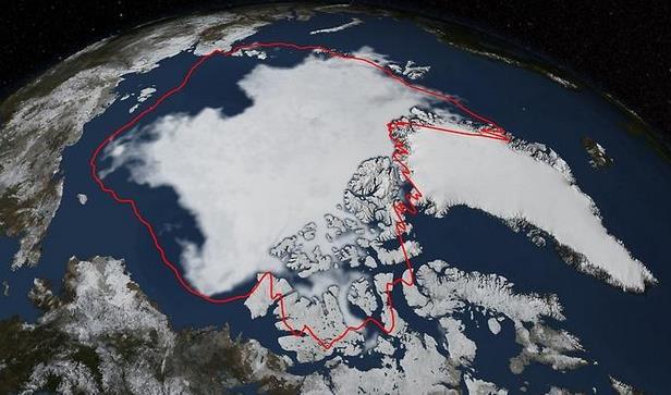
Thinner Too, Arctic Sea Ice Minimum Sixth Lowest on Record. Science 2.0 has an update on what's happening at the top of the world; here's a clip: "
Arctic
sea ice coverage declined to its annual minimum on September 17th and
the National Snow and Ice Data Center (NSIDC) at the University of
Colorado, Boulder find that this year's minimum extent is similar to
last year's and below the 1981-2010 average of 2.40 million square
miles. Over the 2014 summer, Arctic sea ice melted back from its maximum
extent reached in March to a coverage area of 1.94 million square
miles, according to analysis from NASA and NSIDC scientists..."
Image credit above: "
Arctic
sea ice hit its annual minimum on Sept. 17, 2014. The red line in this
image shows the 1981-2010 average minimum extent. Data provided by the
Japan Aerospace Exploration Agency GCOM-W1 satellite." Image: NASA/Goddard Scientific Visualization Studio.
 How Global Warming Affected Extreme Weather Events in 2013 - Interactive
. Following up on yesterday's posts here's an effective interactive infographic from
The Guardian: "
From
Australia’s off-the-charts heat wave to Colorado’s biblical deluge,
Europe’s scorching summer, and Britain’s miserable spring, nine events
were caused at least in part by climate change, scientists conclude in a report
in the Bulletin of the American Meteorological Society on Monday.
Overseen by the US Noaa and the UK Met Office, 92 scientists from 14
countries looked at how climate change affected 16 of the biggest
weather events of 2013."
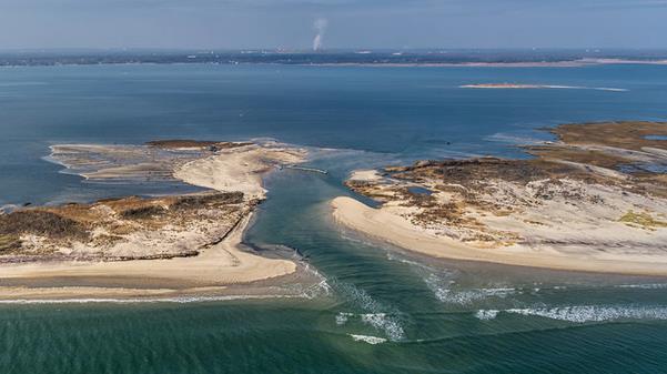
Growing, And Growing Vulnerable. Barrier islands are at special risk from warming/rising seas. Here's a clip from a story at
The New York Times: "...
But the barrier islands that line the Atlantic and Gulf Coasts, from Cape Cod to the Mexican border, are a special case. A new report from the National Research Council
finds that the effect of climate change is especially harsh on these
islands. Population growth in much of this long coast “is nearly twice
the national average,” the report said. Meanwhile, “these same coasts
are subject to impact by some of the most powerful storms on earth and
the destruction potential of these events is increasing due to climate
change and relative sea-level rise...”
Photo credit above: "An aerial view of a breach in the Fire Island National Seashore caused by Hurricane Sandy." Credit National Park Service.


No comments:
Post a Comment