77 F. high in the Twin Cities Wednesday.
71 F. average high on September 17.
67 F. high on September 17, 2013.
September 17 in Minnesota Weather History. Source: MPX National Weather Service:
1997:
An F3 Tornado destroyed several buildings and numerous others damaged.
Hundreds of trees were knocked down. A number of cattle were also killed
in a barn that collapsed. One man was injured when the tornado engulfed
his car and threw it into a nearby woods. A second man was critically
injured when his garage collapsed. He died several weeks later. The
total path length of the tornado from 1 NE of Lastrup to Onamia was 17
miles. Total property damages were estimated at $1.7 Million. In total, 6
tornadoes touched down in Morrison, Mille Lacs, and Kanabec.
1991: Duluth got a 2.5 inch summer snowstorm. (Fall was still five days away)
1971:
A brush fire at Lake Alexander in Morrison County started a 10-foot
wide, 50-foot high "fire whirl." It moved out over the lake, overturned a
1,800 pound pontoon boat, and then dissipated as it moved back to
shore.
1903: 3.75 inches of rain fell in the Minneapolis area.
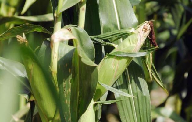
More Boom than Bust
Back
in June, the wettest month on record for the state of Minnesota, who
would have predicted that corn farmers would be faced with another
record harvest, with results so amazing that prices have dropped below
profitability? It's a testament to new seed varieties, precision
farming, and a notable absence of drought and killing hail and wind
storms.
"Another historically wet June has delayed corn and beans
by 7-10 days" said Wayzata-based Al Kluis, who has been tracking Ag crop
commodities for 40 years. But adequate soil moisture and growing degree
days has left fields from the Dakotas to Ohio overflowing with corn,
depressing prices.
How can good weather be bad for business? No, farming is not for the faint of heart.
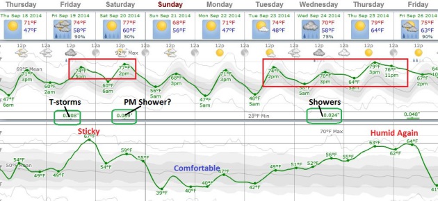
Winds
pick up today; the next frontal passage sparking T-showers late Friday.
A wet start Saturday should give way to lukewarm sun with a shot at 80F
before northwest winds cool us back down early next week. Temperatures
may sink into the low 40s Tuesday morning, but the immediate metro area
should avoid a frost. Long-range guidance shows 70s returning by the end
of next week.
Nothing severe, no storms with names, no weather drama.
Plenty to like about September.
September Mellows.
70s are the rule into much of next week, even a few degrees above
average, in spite of a cool-down early next week. Latest European
guidance isn't nearly as chilly for Monday and Tuesday, as Minnesota
experiences a glancing blow of Canadian air. The best chance of
T-showers: late Friday and Friday night, but an instability shower may
pop up Saturday afternoon, especially north of the Twin Cities. More
showers and T-showers push in by Wednesday of next week. MSP Meteogram:
Weatherspark.
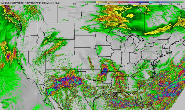
60-Hour Accumulated Rainfall Forecast.
NOAA's 4 KM NAM model prints out some 6"+ amounts for southeastern
Arizona and southern New Mexico, with flash flooding possible as far
east as Texas by Saturday morning. The remains of "Odile" are forecast
to push east, possibly sparking flooding rains as far east as Wichita,
Tulsa and Little Rock. Florida may also experience significant flooding
in the coming days. Graphic: HAMweather.
Oh No, This Is Exactly How Last Winter Started.
Early season snows from Rapid City to Denver; does this mean another
winter tracking the dreaded Polar Vortex? Not necessarily, as
meteorologist Eric Holthaus explains in this excellent overview at
Slate; here's an excerpt: "...
So, sticking to the science, what can we actually expect for the coming winter? Using the Climate Prediction Center’s freshly updated
long-range model suite, now’s as good a time as any to take a first
guess. These models take into account semi-stable patterns of ocean
temperatures to predict areas of relative drought and excess rain and
warmth and frigidity over the next few months, and their historical
accuracy is better than a random guess..."
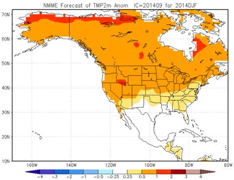
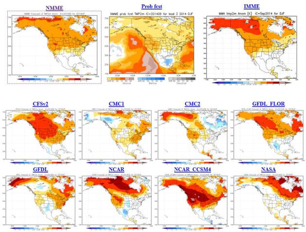
Image credit above: NOAA CPC NMME. "
Breathe easy: This winter is looking warmer than average for most of North America."
Long-Range Winter Guidance: Models Trending Milder than Average.
Would I bet the farm based on a 3-6 month climate model trend?
Absolutely not. But to counter the growing sense of paranoia out there
("Paul, are we going to suffer through another polar vortex - is the
Farmer's Almanac right?") I wanted to include the latest
December-January-February guidance from various NOAA models. Not one
shows a persistently bitter solution for Minnesota or the Lower 48
states - in fact temperatures anomalies range from .5 to 2C warmer than
average. Not exactly a heat wave, but I still believe the upcoming
winter will be a bit easier to take than last year.
NASA Ranks This August As Warmest On Record.
Climate Central has more details; here's an excerpt: "
While
this summer may have felt like fall across much of the eastern half of
the U.S., worldwide the overall picture was a warm one. This August was
the warmest August on record globally, according to newly released NASA temperature data, while the summer tied for the fourth warmest. Central
Europe, northern Africa, parts of South America, and the western
portions of North America (including Alaska) were just some of the spots on the globe that saw much higher than normal temperatures for the month. Large parts of the oceans were also running unusually warm..."
Image credit above: "
Temperature anomalies (in degrees Celsius) of various regions around the world in August 2014." Credit: NASA
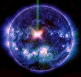
NASA Releases IRIS Footage of X-Class Flare. Here's the intro to a story and video link from Science Codex: "On Sept. 10, 2014, NASA's newest solar observatory, the Interface Region Imaging Spectrograph,
or IRIS, mission joined other telescopes to witness an X-class flare –
an example of one of the strongest solar flares -- on the sun. Combing
observations from more than one telescope helps create a much more
complete picture of such events on our closest star. Watch the movie to see how the flare appears different through the eyes of IRIS than it does through NASA's Solar Dynamics Observatory..."
Image credit: NASA Solar Dynamics Observatory.
How America Forecasts The Weather. Here's an excerpt of an interesting interview with National Weather Service Dr. Louis Uccellini at Piqued: "...
We
are actually showing more success with [predicting] extreme events now
than ever before and are now able to forecast the likelihood of an
extreme weather event 4 to 8 days in advance. However, [forecasting]
the magnitude of the event still remains a challenge. We have seen some
notable precipitation events in the past year such as the ones in
Florida and in Georgia where heavy rainfall was predicted, but not the
20 inches that actually occurred. The same thing happened in Colorado
last year, and it was a very tough forecast in that the atmosphere was
not in one of its more predictable states..."
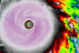
New Way to Predict Hurricane Strength, Destruction.
Factoring in IKE seems like a big step forward. As Sandy demonstrated,
even a marginal Category 1 hurricane can be catastrophic. The current
system doesn't take into account size and ultimate strength. Here's an
excerpt from
ScienceDaily: "...
The
model predicts the amount of integrated kinetic energy within Atlantic
tropical cyclones. This kinetic energy metric is related to the overall
size and strength of a storm, not just the maximum wind speed.
Predictions of this metric complement existing forecasting tools,
potentially allowing forecasters to better assess the risk of hurricanes
that make landfall. "We don't perceive this to be an alternative to how
storms are explained to the public, but a complement," Misra said.
Hurricane forecasts have traditionally focused on wind speeds as
measured through the Saffir-Simpson Hurricane Wind Scale..."
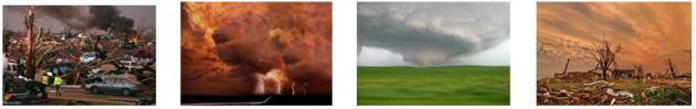
Tornadoes Occurring Earlier in Tornado Alley. Another symptom of warming or a statistical fluke? Here's a snippet of some interesting new research highlighted at
phys.org: "
Peak
tornado activity in the central and southern Great Plains of the United
States is occurring up to two weeks earlier than it did half a century
ago, according to a new study whose findings could help states in
"Tornado Alley" better prepare for these violent storms. Tornado records
from Nebraska, Kansas, Oklahoma, and northern Texas - an area of high
tornado activity dubbed "Tornado Alley" - show that peak tornado
activity is starting and ending earlier than it did 60 years ago..."
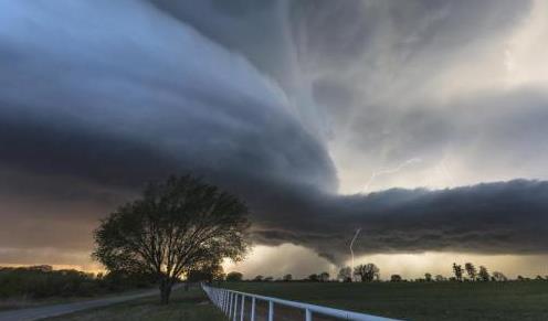
Photo credit above: "
A
supercell storm, known to produce violent tornadoes, forms in Courtney,
Oklahoma in April 2014. A new study shows that peak tornado activity is
occurring nearly two weeks earlier in Oklahoma, Kansas and northern
Texas, according to a new study published in Geophysical Research
Letters." Credit: Kelly DeLay/Flickr.
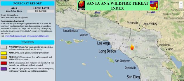
"Santa Ana Wildfire Threat Index" Unveiled. We rate every other kind of natural disaster, why not the risk of wildfires?
The Desert Sun has an interesting update; here's a clip: "
A
web-based weather monitoring system designed to “quantify” the risks of
wildfires during Santa Ana windstorms will equip first responders and
the public with the information they need to be prepared for an
emergency, officials said Wednesday. U.S. Forest Service rangers, along
with representatives from San Diego Gas & Electric and UCLA, jointly
developed the Santa Ana Wildfire Threat Index, which was unveiled
during a briefing at the USFS's Southern California Geographic Area
Coordination Center in Riverside..."
A
supercell storm, known to produce violent tornadoes, forms in Courtney,
Oklahoma in April 2014. A new study shows that peak tornado activity is
occurring nearly two weeks earlier in Oklahoma, Kansas, and northern
Texas, according to a new study published in
Geophysical Research Letters. Credit: Kelly DeLay/Flickr
Read more at:
http://phys.org/news/2014-09-tornadoes-earlier-tornado-alley.html#jCp
Peak
tornado activity in the central and southern Great Plains of the United
States is occurring up to two weeks earlier than it did half a century
ago, according to a new study whose findings could help states in
"Tornado Alley" better prepare for these violent storms.
Read more at:
http://phys.org/news/2014-09-tornadoes-earlier-tornado-alley.html#jCpWhy Weather Matters When You're Depressed. Here's a clip from a story at
Everyday Health that got my attention: "
New research suggests that exposure to sunshine affects suicide rates, regardless of what time of year it is. Published in JAMA Psychiatry,
the study looked at the relationship between daily suicide rates –
69,462 over 40 years – and hours of daily sunshine independent of
season. The study linked higher rates of suicide with shorter durations
of sunny weather – 10 days of fewer – regardless of season, says Norman Sussman, MD,
professor of psychiatry and director of the Treatment Resistant
Depression Program at NYU Langone Medical Center, who was not involved
in the study..."
How a Simple Blood Test Can Now Help Diagnose Depression.
Fast Company has the story.
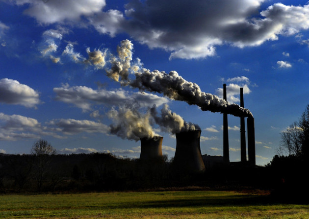
Study Links Increased Drilling With Earthquakes. Wait, injecting water and chemicals deep underground might have a downside? Imagine that. Here's a clip from a
Wall Street Journal story: "
A
magnitude 5.3 earthquake that hit Colorado in 2011 was likely caused by
the injection of wastewater into the ground, a process used in
natural-gas drilling, according to new research to be released Tuesday.
The new study, published in the Bulletin of the Seismological Society of
America, adds more detail to a growing body of work seeking to
establish and explain the connection between human activity and seismic
events, known as induced quakes..."
Photo credit above: "
The
aftermath of an earthquake in Segundo, Colo., in 2011. Scientists have
linked the magnitude-5.3 quake with nearby wastewater injection, a
process used in drilling."
Associated Press.
Together We Make Football. Grantland takes a look at the dark underbelly of America's favorite sport, the NFL and domestic violence; here's an excerpt: "...The
video did something else. Its existence turned what had been a serious
but abstract problem into a scandal. It brought greater awareness to the
NFL’s long history of tolerating high rates of domestic violence, but
it didn’t prompt most people to explore why. The story became a kind of
conspiracy, talked about in excited tones. Had Goodell seen the tape? If
he hadn’t, why hadn’t he? Was he incompetent? Who knew what, and when?
Was there a conspiracy here? Who was lying? What else was the league
hiding? Conveniently, these were questions with answers. This was a
crime that could be solved. The problem had a clean solution: Get rid of
Roger Goodell..."
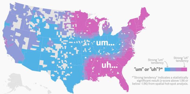
Uh, Here's an Interesting Bit of Useless Trivia.
Do you say um or uh? If you live in Minnesota or Wisconsin you may be
predisposed to mumble uh vs. um. I know, fascinating. Here's
more...uh...detail from Quartz: "...Every
language has filler words that speakers use in nervous moments or to
buy time while thinking. Two of the most common of these in English are
“uh” and “um.” They might seem interchangeable, but data show that their
usage break down across surprising geographic lines. Hmm. The map above
shows a preliminary attempt to use the tremendous amount of linguistic
data being produced on the web to understand how language works..."
Map credit: Quartz, Twitter, analysis by Dr. Jack Grieve.
Egypt's New Stamp Mixes Up Suez and Panama Canals. Someone's not getting a promotion.
France 24 has the head-scratching details: "
To celebrate the planned extension of the Suez Canal,
Egypt decided to commission a line of stamps showing off the
multi-billion dollar project. The only problem is that the designers
seem to have confused their canals. Some of the stamps show the Panama
Canal, located in Central America. Embarrassed authorities announced
Sunday that they were halting the stamps’ production. .."
Image credit above: "
On the left, Egypt's stamp of the "Suez Canal", on the right, a photograph of the Panama Canal."
TODAY: Partly sunny and breezy. Winds: SE 10+ High: near 70
THURSDAY NIGHT: Clouds increase, not as cool. Low: 58
FRIDAY: Unsettled, few T-showers expected. Dew point: 62 High: 75
SATURDAY: Partly sunny and mild. PM clouds, a few showers north of MSP. Wake-up: 64. High: 78, falling during the PM hours
SUNDAY: Mix of clouds and sun, cooler. Wake-up: 57. High: 68
MONDAY: Blue sky, hints of October. Wake-up: 49. High: 63
TUESDAY: Chilly start, bright sun. Dew point: 37. Wake-up: 43. High: near 71
WEDNESDAY: Clouds increase, a few showers late. Wake-up: 47. High: near 70
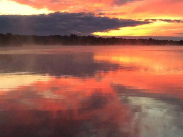
* photo credit above: Dan Durkin.
Climate Stories...
U.S. Moves to Reduce Global Warming Emissions. Coral Davenport at
The New York Times has the story; here's the introduction: "
The
Obama administration on Tuesday announced a series of moves aimed at
cutting emissions of hydrofluorocarbons, or HFCs, powerful greenhouse
gases that contribute to climate change. The White House has secured
voluntary agreements from some of the nation’s largest companies to
scale down or phase out their use of HFCs, which are factory-made gases
used in air conditioning and refrigeration. Coca-Cola, Pepsi, Red Bull,
Kroger, Honeywell and DuPont, the company that invented fluorinated
refrigerants, have agreed to cut their use and replace them with
climate-friendly alternatives..."
Natural Disasters Displaced More People Than War in 2013, Study Finds. Here's a clip from an article at
The Guardian: "
Natural
disasters displaced three times as many people as war last year – even
as 2013 was a horrific year for conflict – with 22 million people driven
out of their homes by floods, hurricanes and other hazards, a new study
has found. Twice as many people now lose their homes to disaster as in
the 1970s, and more people move into harm’s way each year, the study by
the Norwegian Refugee Council found. “Basically, the combination of mega
natural disasters and hundreds of smaller natural disasters massively
displaces people in many more countries than the countries that have war
and conflict,” said Jan Egeland, the secretary of the Norwegian refugee
council..."
*
Catholic Online has another perspective
here.
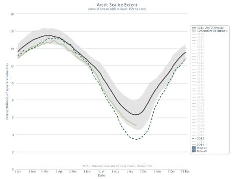
Antarctic Sea Ice Set for Record High as Arctic Heads for 6th Lowest Extent. Here's an excerpt from
The Guardian: "...
Figures released by the National Snow and Ice Data Centre in Boulder, Colorado,
show that the so-called Arctic sea ice minimum – the point where the
extent of sea ice there is at its lowest after the summer, before it
begins to refreeze for winter – is expected to be confirmed imminently
and would be millions of square kilometres below the long-term average.
At 5.09m sq km, the extent of Arctic sea ice this year would be the
sixth lowest on record, slightly worse than last year, though not as extreme as the record set in 2012 when it plunged to less than 3.5 million square kilometres..." (Graphic: NSIDC).
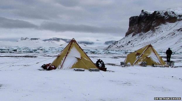
Antarctic Peninsula Glacier Recession "Unprecedented".
The BBC has the story - here's an excerpt: "
Glaciers
around the Antarctic Peninsula are melting faster than ever despite
more snowfall, say experts. Prof Neil Glasser, from Aberystwyth
University, was part of a team who studied the ice-core data on a 4km
long glacier on James Ross Island. He said over the next 200 years it
"will become far smaller than at any point over the last 10,000 years."
The research published in the journal Nature Climate Change says it will lead to an increase in sea level..."
Photo credit above: "
The study looked at changes in glaciers over the last 10,000 years around the Antarctic Peninsula."
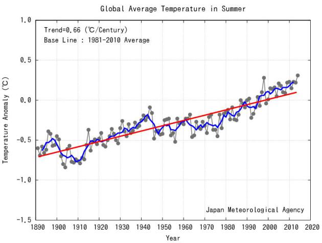
2014: Warmest Summer, Worldwide, Since 1891. This, according to JMA,
The Japan Meteorological Agency, which adds: "
The
seasonal anomaly of the global average surface temperature in Summer
(June to August) 2014 (i.e. the average of the near-surface air
temperature over land and the SST) was +0.31°C above the 1981-2010
average (+0.65°C above the 20th century average), and was the warmest
since 1891. On a longer time scale, global average surface temperatures
have risen at a rate of about 0.66°C per century.."
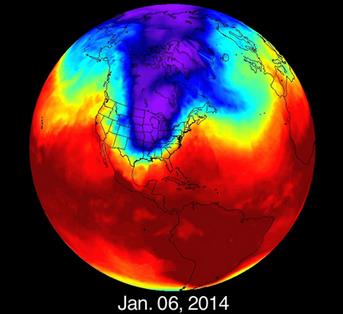
Polar Vortex Excursions Linked to Global Warming.
This is precisely what I've been seeing on the maps, especially since
2010: a slower-moving, higher-amplitude pattern over North America with
weather becoming increasingly "stuck", stalled for extended periods of
time, magnifying both flood, drought, heat and cold. Here's an excerpt
from
Slate: "
Over the past year or so, I’ve written a few times
on how the “polar vortex”—actually, deep meanders or excursions in the
usually stable west-to-east direction of the polar cyclonic air
stream—may be tied to global warming, but there hadn’t been enough
research done yet to be sure. Well, here we go: A team of Korean and
American scientists has made the connection. Warmer waters lead to more
melting of Arctic ice, which destabilizes the polar jet stream. My Slate colleague Eric Holthaus has an excellent write-up of it, and I wanted to give him a signal boost here. Go read it..."
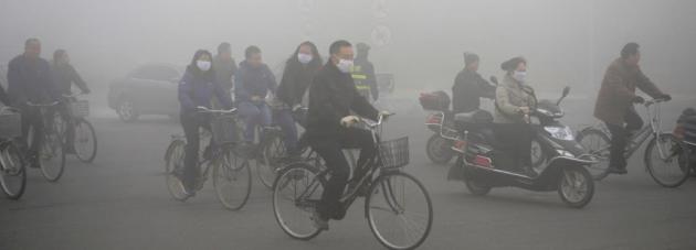
China, The Climate, and The Fate of the Planet. China is now the largest source of greenhouse gases, and
Rolling Stone
takes a look at how the zeal for economic growth, at any cost, may
impact CO2 levels and the ability to contain worldwide warming within a
level in which the world can still adapt. Here's an excerpt: "...
The
blunt truth is that what China decides to do in the next decade will
likely determine whether or not mankind can halt – or at least
ameliorate – global warming. The view among a number of prominent
climate scientists is that if China's emissions peak around 2025, we may
– just barely – have a shot at stabilizing the climate before all hell
breaks loose. But the Chinese have resisted international pressure to
curb their emissions. For years, they have used the argument that they
are poor, the West is rich, and that the high levels of carbon in the
atmosphere were caused by America's and Europe's 200-year-long
fossilfuel binge. Climate change is your problem, they argued – you
deal with it. But that logic doesn't hold anymore..."
Photo credit above: "
A red-alert smog day in China last year. Pollution has become a public-health hazard." Reuters/Landov.
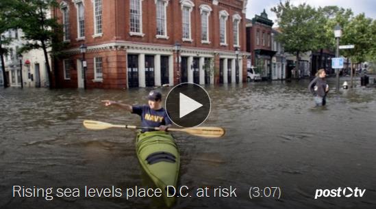
Climate Expert: "Washington D.C. Faces Significant Risk of Record High Floods."
Maybe this will wake up the politicians who refuse to believe the
science and mounting evidence. Here's a video and story excerpt from
The Washington Post's Capital Weather Gang: "
A rise
in local tidal waters – fueled by global warming – virtually guarantees
record flooding in Washington, D.C. over the next century, concludes a
new analysis on sea level rise and flood risk. The analysis from Climate Central –
a non-profit science communication organization based in Princeton,
N.J. — finds that the cumulative risk of a record-setting flood grows by
the decade as sea levels rise. “I would say the headline is that
Washington, D.C. faces significant risk of record high floods within the
coming few decades,” says Ben Strauss, Climate Central’s vice president
for climate impacts..."
Fixing Climate Change May Add No Costs, Report Says. Overly optimistic? Or will the move toward zero-carbon invigorate global economies? Here's an excerpt of a
New York Times story from Justin Gillis: "...
A
global commission will announce its finding on Tuesday that an
ambitious series of measures to limit emissions would cost $4 trillion
or so over the next 15 years, an increase of roughly 5 percent over the
amount that would likely be spent anyway on new power plants, transit
systems and other infrastructure. When the secondary benefits of greener
policies — like lower fuel costs, fewer premature deaths from air
pollution and reduced medical bills — are taken into account, the
changes might wind up saving money, according to the findings of the
group, the Global Commission on the Economy and Climate..."
Jellyfish: It's What's For Dinner.
Mmmm. Please pass the "jellyballs" please. I pray that never comes out
of my mouth, but it turns out there is a large and growing appetite for
jellyfish, as
Modern Farmer explains. Here's a clip: "...
At
the Golden Island plant, the jellies are dried and shipped to China and
Japan, where they are cut into long, thin strips and served in salads
with cabbage and teriyaki sauce. If prepared right, the jellyfish are
crunchy, like a carrot. Jellyfish are popular in China, along with other
sea creatures like geoducks (those gigantic phallic clams from the
Pacific Northwest) for similar textural reasons. But these sorts of
foods are being embraced well beyond Asia. And as climate change and the
global industrial agriculture system continue on what many view as a
doomed course, we may have no choice but to eat foods that make sense
ecologically — or can at least thrive in a changed environment..."
Major Food Companies Warn Climate Change Threatens Business.
From first-hand meetings and observations I can tell you that
Minnesota's largest food companies are paying close attention to climate
change and increasingly erratic weather patterns, worldwide. There is
very little science denial within these corporations. They can see the
impact in their fields, and in the data. Here's an excerpt from
Think Progress: "...
While
politicians continue to bicker over whether or not climate change
exists, companies now have no choice in the matter — they must
acknowledge the science and the risk and disclose the reality of that
risk to their investors’ pocketbooks. Whether that risk actually
manifests itself is another matter, but the fact that companies are
increasingly putting climate change on their threat lists speaks volumes
to the severity of the problem. Here are seven other big food companies
that disclose to investors that climate change poses a threat to their
products and bottom lines..."
Photo credit: AP Photo/Gene J. Puskar.
No Rain for Decades: Stand By For The "Megadroughts", Scientists Warn.
The Independent has the story; here's an excerpt: "...
Experts
warn the droughts could be even more severe than the prolonged water
shortage currently afflicting California, where residents have resorted
to stealing from fire hydrants amid mass crop failures and regular
wildfires. Megadroughts – which are generally defined as lasting 35
years or more – will become considerably more frequent as global warming
increases temperatures and reduces rainfall in regions already
susceptible, warns Cornell University’s Dr Toby Ault, the author of the
new report..."


No comments:
Post a Comment