57 F. high in the Twin Cities Thursday. That's the average high on October 19.
74 F. average high on September 11.
86 F. high on September 11, 2013.
September 11 in Minnesota Weather History. Source: MPX National Weather Service:
1982: Two tornadoes touched down in Benton County. The F2 tornado caused $250,000 worth of damaged and the F0 caused $25,000.
1931: The fifth consecutive day of 90 degrees or above in the Minneapolis area.
1923: Snow pays an early visit to northern Minnesota. Some cities that saw flurries and sleet were Roseau and Virginia.
1903: 4.96 inches of rain fell in the Minneapolis area.
1869: A hail storm between 1 and 3 am broke windows and caused considerable damage to late vegetables at Madilia in Watonwan County.
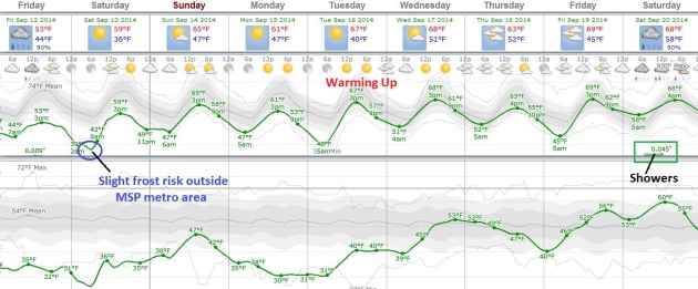
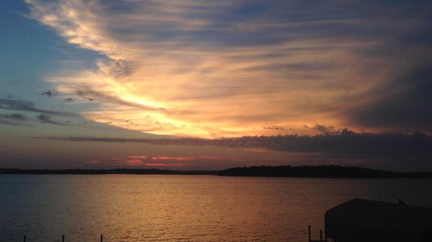
Frosty Possibilities
No,
the growing season isn't over. Not yet. Odds are plants and flowers
within 25 miles of Minneapolis and St. Paul will not freeze their buds
off early Saturday.
Thank the urban heat island for that. Concrete
and asphalt absorbs heat during the day and slowly radiates it into
space at night, acting as a thermal blanket.
Frost during the
second week of September is a bit unusual, but not unprecedented. The
mercury at MSP International sank to a crisp 32F on September 3, 1974.
The locals were not amused.
It may be hard to imagine out there
today, with building clouds and showers over southern Minnesota keeping
temperatures in the low 50s, more than 20F cooler than average, but you
should be able to work up a minor sweat within a week. Long-range
guidance shows a warming trend next week; 80F not out of the question
next Friday and Saturday.
You'll need a jacket or sweatshirt for Friday football games; the best chance of a cold rain south of the Minnesota River.
Our
internal models show the best chance of frost over southeastern
Minnesota early Saturday, but highs rebound to near 60F tomorrow;
mid-60s Sunday. At the risk of playing therapist - a milder spell is
imminent.
Fresh Air Next 24 Hours - Warming Up Next Week.
Long-range guidance shows a generally dry pattern, the best chance of
rain coming a week from Saturday. One benefit of this cool push - it's
keeping the strongest storms well south of Minnesota. Southern counties
are brushed with light rain today but we dry out over the weekend with a
streak of 60s, even a few low 70s next week. Graphic: Weatherspark.
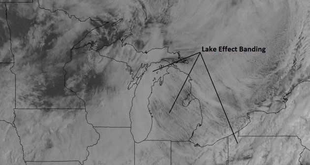
A Bit Early For Lake Effect.
Thursday's visible cloud imagery showed lake effect cloud banding
downwind of the (relatively) warm Great Lakes. 1 KM visible imagery
courtesy of NOAA and HAMweather.
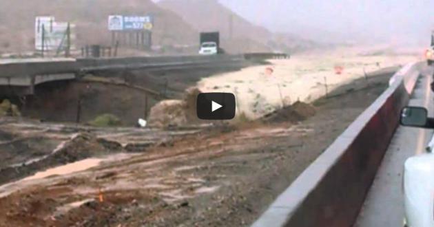
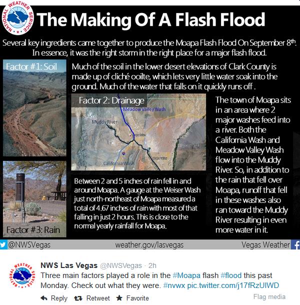
This Is Why You Should Never Drive Into a Flash Flood. Meteorologist Andrew Freedman has the back-story and harrowing video clip at
Mashable; here's the intro: "
Flash
floods are one of the biggest weather-related killers in the United
States, with most related deaths occurring in vehicles. The National
Weather Service's "Turn Around, Don't Drown!" campaign is designed to
discourage people from driving into deceptively shallow waters that can
easily trap or carry their vehicles downstream. On Monday and Tuesday,
as the remnants of Hurricane Norbert dumped a record amount of rain
in Arizona and Nevada, people driving on major interstates found
themselves in the path of suddenly raging rivers. The video above was
reportedly filmed on Interstate 5, outside of Las Vegas; according to
the Fox affiliate in Phoenix, Arizona, it was taken by Shane Dukeman, a
truck driver from southern Arizona..."
No Named Storms First Time Since 2000 at Peak. The Atlantic is supernaturally quiet for September, peak hurricane month, while the eastern Pacific may
run out of names at the rate we're going (up to the O's). Here's an excerpt from
Bloomberg: "...
The
season isn’t over and it is not shut down,” Bell said by telephone.
“While it is weaker than average we already had one hurricane strike North Carolina
this year. We need people to stay prepared.” It is also too early to
tell if there is a larger shift under way in the Atlantic that could
herald in an era of fewer storms, he said. The Atlantic hasn’t been this
quiet since 1992. In 2000, a sub-tropical depression plowed its way
across the basin southwest of Bermuda on Sept. 10, however, it didn’t get its name, Florence, until early Sept. 11. It became a hurricane later that day..."
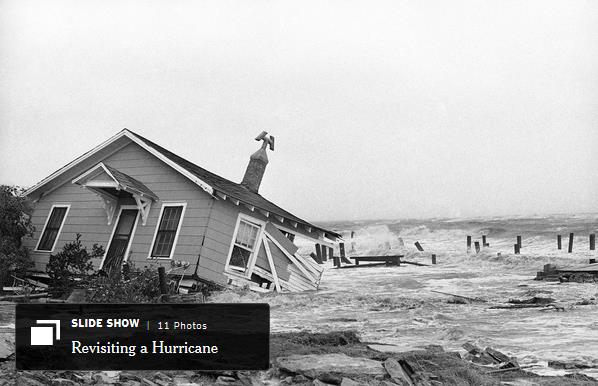
A Hurricane In 1964, And What Came After.
Yes, the Atlantic is quiet, and has been for the last couple of years.
But as my financial planner is fond of reminding me, past returns are no
reflection of future results. No kidding. Here's an excerpt from
The Upshot at The New York Times: "
After
several relatively quiet years, the Atlantic hurricane season of 1964
struck with renewed vigor, especially in Florida. Fifty years ago this
week, Hurricane Dora, a Category 4 storm, came ashore in the state’s
northeast corner, causing five deaths and $250 million in damage ($1.9
billion in today’s money). Two weeks earlier, Hurricane Cleo killed 214
people in the Caribbean before raking Miami with gusts of up to 135
miles per hour. Four hurricanes would ultimately come ashore in the
United States that year, the most since 1933. All four at least touched Florida, ending a 12-year quiet period for the state..."
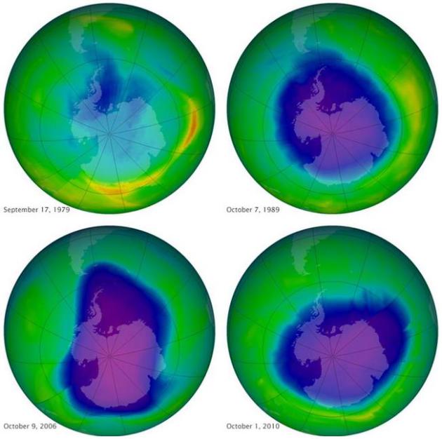
Scientists Say Ozone Layer Recovering.
In the 1970s scientists realized the CFC's were drifting into the upper
atmosphere, depleting stratospheric ozone levels, increasing the risk
of skin cancer and other ailments at ground level. An international
treaty signed in 1987 phased out these harmful chemicals, and there has
been a slow recovery, as reported by AP and
The Boston Globe: "
Earth’s protective ozone layer is beginning to recover, largely because
of the phase-out since the 1980s of certain chemicals used in
refrigerants and aerosol cans, a UN scientific panel reported Wednesday
in a rare piece of good news about the health of the planet. Scientists
said the development demonstrates that when the world comes together, it
can counteract a brewing ecological crisis. For the first time in 35
years, scientists were able to confirm a statistically significant and
sustained increase in stratospheric ozone, which shields the planet from
solar radiation that causes skin cancer, crop damage, and other
problems..."
Image credit above: "
A NASA image of
the ozone layer over the past 35 years. From 2000 to 2013, ozone levels
climbed 4 percent in the key mid-northern latitudes at about 30 miles up."
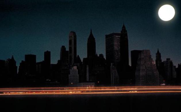
U.S. Grid Safe From Large-Scale Attack. I hope the experts are right about this one. Here's more reassuring news, a snippet of a story at
Politico: "...
But
in fact, the half-dozen security experts interviewed for this article
agreed it’s virtually impossible for an online-only attack to cause a
widespread or prolonged outage of the North American power grid. Even
laying the groundwork for such a cyber operation could qualify as an act
of war against the U.S. — a line that few nation-state-backed hacker
crews would wish to cross. None denied that determined hackers could
penetrate the networks of bulk power providers. But there’s a huge gap
between that and causing a civilization-ending sustained outage of the
grid..."
File photo credit above: National Geographic.
“To ease another's heartache is to forget one's own.” – Abraham Lincoln
TODAY: Mostly cloudy, showers far south. Winds: NW 8. High: 56
FRIDAY NIGHT: Evening shower far southern Minnesota, then clearing. Low: 36
SATURDAY: Frost risk early, mainly outside the MSP metro area. Bright sun. High: near 60
SUNDAY: Partly sunny, dry. Dew point: 45. Wake-up: 45. High: 64
MONDAY: Clearing, a bit cooler. Wake-up: 46. High: 59
TUESDAY: Sunny. Fewer bugs - in theory. Wake-up: 39. High: 65
WEDNESDAY: Blue sky, soft breeze. Wake-up: 48. High: 69
THURSDAY: Lukewarm sun, very pleasant. Wake-up: 51. High: 73
Climate Stories...
Climate Change Gets Personal As Minnesota Faces Loss of It's Beloved Loon.
It won't happen overnight, but at the rate we're going loon sightings
may become increasingly rare for our grandkids; here's an excerpt from
ThinkProgress: "...
This week, the Audubon Society released a comprehensive report
on the threats North America’s birds face from climate change. The
report found that the common loon, Minnesota’s beloved state bird, is
projected to have just 25 percent of its non-breeding season range and
44 percent of its breeding season range left by 2080. Due to warming
temperatures and changing weather patterns, the report states, “it looks
all but certain that Minnesota will lose its iconic loons in summer by
the end of the century.” The common loon has a better chance
than some other birds of being able to adapt to a new, more northern
habitat as the earth warms, but that still means Minnesota won’t have
the loons its residents have long been used to..."
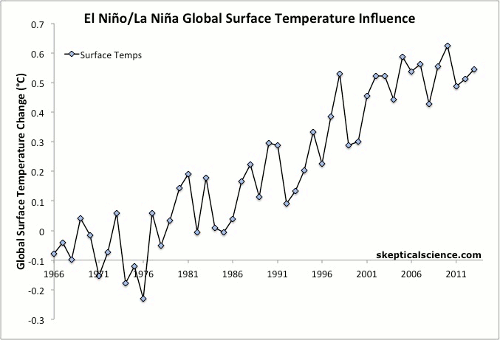
ENSO Temperature Trends. Skeptical Science
has an illuminating animation (above) that shows the influence of La
Nina and El Nino on global surface temperature trends. Any way you slice
and dice it, data shows a continuing warming trend; here's an excerpt:
"...
In this analysis, each year was classified as either an El Niño,
La Niña, or ENSO-neutral year based on the average of 3 common ENSO
indices. The years were then ranked and the top, middle, and bottom
approximately one-third of the ranked years were classified as El Niño,
neutral, and La Niña years, as described here.
Years that were strongly influenced by the volcanic eruptions of El
Chichón (1983–1985) and Mount Pinatubo (1992–1994) were excluded from
the analysis due to the temporary cooling effect of volcanic aerosols..."
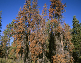 Climate Change Accelerating Death of Western Forests.
Warmer, drier overall, creating an environment where pests, especially
pine beetles, can weaken trees, making them more prone to drought and
fire. Here's a clip from
USA TODAY: "...
Colorado alone could lose 45% of its aspen stands over the next 45 years, says the report released Thursday by the Union of Concerned Scientists and the Rocky Mountain Climate Organization.
Pine bark beetles alone have killed 46 million acres of trees across
the west, an area nearly the size of Colorado. "The wildfires,
infestations and heat and drought stress are the symptoms; climate
change is the underlying disease," Jason Funk, the report's co-author and a senior climate scientist at Union of Concerned Scientists, said in a statement..."
The Oceans Are Acidifying At The Fastest Rate in 300 Million Years.
How Bad Could It Get? The oceans absorb roughly a quarter of all
greenhouse gas emissions, but there's a limit to how much carbon can be
soaked up, and now the oceans are (very rapidly) turning more acidic.
Here's an excerpt from
Vox: "
The current rate of ocean acidification appears unprecedented at least over the last 300 million years," noted a report this week from the World Meteorological Organization. That's a big deal — and it's worth unpacking a bit further. The WMO notes
that the oceans currently absorb roughly one-quarter of all the carbon
dioxide that we emit from our cars, factories, and power plants each
year. That process helps fend off (some) global warming, but it
also comes at a cost: As that extra carbon dioxide dissolves in water,
it turns into carbonic acid and decreases the pH levels in the oceans..."
Image credit above:
"Rainbow reef in Fiji. Ocean acidification is expected to affect coral reefs around the world."
David Burdick/Flickr
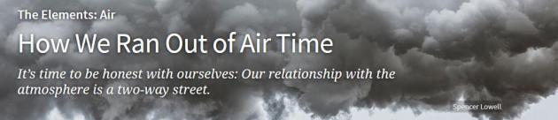
How We Ran Out of Air Time. Andrew Revkin has a story at
Audubon; here's the introduction: "
It
should be no surprise, first of all, that humanity is taking its time
absorbing and confronting what’s going on. Our interactions with
climate, for far more than 99 percent of history, ran in one direction:
Precipitation or temperatures changed, ice sheets or coastlines or
deserts advanced or retreated, and communities thrived, suffered, or
adjusted how or where they lived. Only a couple of decades have passed
since people outside of a tiny community of scientists began to grasp
that the human-climate relationship, in measurable but still subtle
ways, now runs in two directions..."


No comments:
Post a Comment